Rendsville Township, Stevens County, Minnesota

Last updated
Rendsville Township, Minnesota
Township
USA Minnesota location map.svg
Red pog.svg
Rendsville Township, Minnesota
Location within the state of Minnesota
Coordinates: 45°42′39″N95°57′15″W / 45.71083°N 95.95417°W / 45.71083; -95.95417 Coordinates: 45°42′39″N95°57′15″W / 45.71083°N 95.95417°W / 45.71083; -95.95417
Country United States
State Minnesota
County Stevens
Area
  Total 35.0 sq mi (90.5 km2)
  Land 34.4 sq mi (89.0 km2)
  Water 0.6 sq mi (1.5 km2)
Elevation 1,188 ft (362 m)
Population (2000)
  Total 177
  Density 5.1/sq mi (2.0/km2)
Time zone Central (CST) (UTC-6)
  Summer (DST) CDT (UTC-5)
FIPS code 27-53818 [1]
GNIS feature ID 0665398 [2]

Rendsville Township is a township in Stevens County, Minnesota, United States. The population was 177 at the 2000 census.

Stevens County, Minnesota County in the United States

Stevens County is a county in the U.S. state of Minnesota. As of the 2010 United States Census, the population was 9,726. Its county seat is Morris.

Minnesota State of the United States of America

Minnesota is a state in the Upper Midwest, Great Lakes, and northern regions of the United States. Minnesota was admitted as the 32nd U.S. state on May 11, 1858, created from the eastern half of the Minnesota Territory. The state has a large number of lakes, and is known by the slogan the "Land of 10,000 Lakes". Its official motto is L'Étoile du Nord.

Contents

Geography

According to the United States Census Bureau, the township has a total area of 35.0 square miles (90.5 km²); 34.4 square miles (89.0 km²) of it is land and 0.6 square miles (1.5 km²) of it (1.66%) is water.

United States Census Bureau Bureau of the United States responsible for the census and related statistics

The United States Census Bureau is a principal agency of the U.S. Federal Statistical System, responsible for producing data about the American people and economy. The Census Bureau is part of the U.S. Department of Commerce and its director is appointed by the President of the United States.

Demographics

As of the census [1] of 2000, there were 177 people, 67 households, and 55 families residing in the township. The population density was 5.1 people per square mile (2.0/km²). There were 77 housing units at an average density of 2.2/sq mi (0.9/km²). The racial makeup of the township was 99.44% White, and 0.56% from two or more races.

Census Acquiring and recording information about the members of a given population

A census is the procedure of systematically acquiring and recording information about the members of a given population. The term is used mostly in connection with national population and housing censuses; other common censuses include agriculture, business, and traffic censuses. The United Nations defines the essential features of population and housing censuses as "individual enumeration, universality within a defined territory, simultaneity and defined periodicity", and recommends that population censuses be taken at least every 10 years. United Nations recommendations also cover census topics to be collected, official definitions, classifications and other useful information to co-ordinate international practice.

Population density A measurement of population numbers per unit area or volume

Population density is a measurement of population per unit area or unit volume; it is a quantity of type number density. It is frequently applied to living organisms, and most of the time to humans. It is a key geographical term. In simple terms population density refers to the number of people living in an area per kilometer square.

There were 67 households out of which 25.4% had children under the age of 18 living with them, 70.1% were married couples living together, 3.0% had a female householder with no husband present, and 17.9% were non-families. 16.4% of all households were made up of individuals and 10.4% had someone living alone who was 65 years of age or older. The average household size was 2.64 and the average family size was 2.93.

Marriage Social union or legal contract between people called spouses that creates kinship

Marriage, also called matrimony or wedlock, is a socially or ritually recognised union between spouses that establishes rights and obligations between those spouses, as well as between them and any resulting biological or adopted children and affinity. The definition of marriage varies around the world not only between cultures and between religions, but also throughout the history of any given culture and religion, evolving to both expand and constrict in who and what is encompassed, but typically it is principally an institution in which interpersonal relationships, usually sexual, are acknowledged or sanctioned. In some cultures, marriage is recommended or considered to be compulsory before pursuing any sexual activity. When defined broadly, marriage is considered a cultural universal. A marriage ceremony is known as a wedding.

In the township the population was spread out with 19.8% under the age of 18, 9.6% from 18 to 24, 26.6% from 25 to 44, 27.1% from 45 to 64, and 16.9% who were 65 years of age or older. The median age was 41 years. For every 100 females, there were 124.1 males. For every 100 females age 18 and over, there were 121.9 males.

The median income for a household in the township was $41,250, and the median income for a family was $48,750. Males had a median income of $24,375 versus $11,875 for females. The per capita income for the township was $19,554. About 4.2% of families and 7.7% of the population were below the poverty line, including 28.6% of those under the age of eighteen and 9.5% of those sixty five or over.

Per capita income mean income of the people in an economic unit such as a country or city

Per capita income (PCI) or average income measures the average income earned per person in a given area in a specified year. It is calculated by dividing the area's total income by its total population.

Related Research Articles

Freeport, Michigan Village in Michigan, United States

Freeport is a village in Barry County in the U.S. state of Michigan. The population was 483 at the 2010 census. The village is mostly within Irving Township, though a small portion lies in Carlton Township.

White Oak Township, Michigan Township in Michigan, United States

White Oak Township is a civil township of Ingham County in the U.S. state of Michigan. The population was 1,177 at the 2000 census.

Ewing Township, Michigan Civil township in Michigan, United States

Ewing Township is a civil township of Marquette County in the U.S. state of Michigan. As of the 2000 census, the township population was 159.

Larkin Charter Township, Michigan Charter township in Michigan, United States

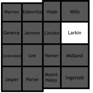
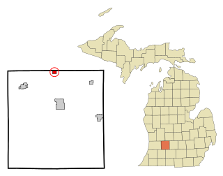
Larkin Charter Township is a charter township of Midland County in the U.S. state of Michigan. The population was 4,514 at the 2000 census.

West Branch Township, Ogemaw County, Michigan Township in Michigan, United States

West Branch Township is a civil township of Ogemaw County in the U.S. state of Michigan. The population was 2,628 at the 2000 census. The city of West Branch is located within the township.

Bearinger Township, Michigan Civil township in Michigan, United States

Bearinger Township is a civil township of Presque Isle County in the U.S. state of Michigan. As of the 2010 census, the township population was 369.

Case Township, Michigan Civil township in Michigan, United States

Case Township is a civil township of Presque Isle County in the U.S. state of Michigan. The population was 942 at the 2000 census.

Fort Ripley Township, Crow Wing County, Minnesota Township in Minnesota, United States

Fort Ripley Township is a township in Crow Wing County, Minnesota, United States. The population was 600 at the 2000 census.

Wanamingo Township, Goodhue County, Minnesota Township in Minnesota, United States

Wanamingo Township is a township in Goodhue County, Minnesota, United States. The population was 504 at the 2000 census.

Houston Township, Houston County, Minnesota Township in Minnesota, United States

Houston Township is a township in Houston County, Minnesota, United States. The population was 438 at the 2000 census.

Nashwauk Township, Itasca County, Minnesota Township in Minnesota, United States

Nashwauk Township is a township in Itasca County, Minnesota, United States. The population was 1,681 at the 2010 census.

Ash Lake Township, Lincoln County, Minnesota Township in Minnesota, United States

Ash Lake Township is a township in Lincoln County, Minnesota, United States. The population was 177 at the 2000 census.

Cedar Mills Township, Meeker County, Minnesota Township in Minnesota, United States

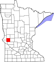
Cedar Mills Township is a township in Meeker County, Minnesota, United States. The population was 499 at the 2000 census.

Oshawa Township, Nicollet County, Minnesota Township in Minnesota, United States

Oshawa Township is a township in Nicollet County, Minnesota, in the United States. The population was 525 at the 2000 census.

Winger Township, Polk County, Minnesota Township in Minnesota, United States

Winger Township is a township in Polk County, Minnesota, United States. It is part of the Grand Forks-ND-MN Metropolitan Statistical Area. The population was 177 at the 2000 census.

Aurora Township, Steele County, Minnesota Township in Minnesota, United States

Aurora Township is a township in Steele County, Minnesota, United States. The population was 625 at the 2000 census.

Sadsbury Township, Crawford County, Pennsylvania Township in Pennsylvania, United States

Sadsbury Township is a township in Crawford County, Pennsylvania, United States. The population was 2,933 at the 2010 census.

Coolbaugh Township, Monroe County, Pennsylvania Place in Pennsylvania, United States

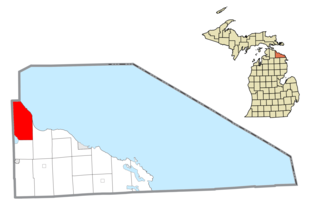
Coolbaugh Township is a township in Monroe County, Pennsylvania, United States. The population was 20,564 at the 2010 census. Tobyhanna State Park is in Coolbaugh Township.

West Pottsgrove Township, Montgomery County, Pennsylvania Township in Pennsylvania, United States

West Pottsgrove Township is a township in Montgomery County, Pennsylvania, United States. The population was 3,874 at the 2010 census.

York Township, York County, Pennsylvania Township in Pennsylvania, United States

York Township is a township in York County, Pennsylvania, United States. The population was 27,793 at the 2010 census.

References