Residential segregation in Greater Vancouver

Last updated

Visible minorities have become highly concentrated in Vancouver and its suburbs. [1] The proportion of visible minorities in Vancouver increased from 14 percent to 55 percent of the population between 1981 and 2021. [2] [3] [4] Vancouver has less residential segregation of its ethnic minorities compared to older Canadian cities such as Montreal. [5] However, Vancouver exhibits some residential segregation, as demographic data shows visible minority concentrations vary by neighbourhood in Vancouver. [5] In general, East Vancouver has higher visible minority concentrations than the West Side. [5] Higher visible minority concentrations are also found in nearby suburbs such as Richmond, Surrey, Burnaby, and New Westminster. [5] Most recent immigrants choose to locate in peripheral neighbourhoods in Greater Vancouver. [6] It is speculated that Canada's multiculturalism policies may have prevented greater segregation from the dominant groups in both the residential location and the labour market. [7]

Contents

Causes

Segregation may have both voluntary and involuntary causes, [7] so residential segregation is not necessarily due to racism. Since a large number of visible minorities in Vancouver are recent immigrants and from non-Western countries, sense of ethnic identity, languages and custom make immigrants to voluntarily choose to live in racially segregated neighbourhoods. [7] Immigrant settlement patterns in Canada are closely related to circumstances in the housing market, [5] but immigrants vary significantly in terms of their socioeconomic status and housing conditions. [5] Housing affordability segregates people in different socioeconomic class. [5] Housing affordability segregates different racial groups as well since visible minorities, both Canadian-born and foreign-born, have lower earnings than the white population. [5] Hence, less visible minorities concentration in affluent Vancouver neighbourhoods such as Point Grey, Kitsilano or even affluent suburbs such as West Vancouver, [5] whereas higher visible minority concentrations found in East Vancouver and nearby suburbs such as Richmond, Surrey, Burnaby and New Westminster, where housing price is lower comparing to Vancouver Westside. [5] Immigrants are more likely to commute on public transit than the Canadian born, and that they commute from a more geographically dispersed area, so more visible minority immigrant groups live in North, East and Central Vancouver, Surrey and New Westminster, concentrated near routes serviced by the Sky Train and Sea Bus system. [8]

Chinese-Canadians

Chinese immigrants first immigrated to Vancouver during the 1850s owing to railway labour opportunities, coal mining and a gold rush. [9] These early Chinese immigrants formed their own enclaves and Chinatowns in Vancouver and New Westminster because of the Sinophobia of the host society and their lack of knowledge of the English language. [9] In the early years, Chinatown represented otherness, and was associated with crime, unleashed sexuality, opium dens, gambling, filth, run-down housing and mysterious back-alleys. [10] Vancouver Chinatown is undergoing a period of adjustment due to a rapid rise in property assessments and taxes, and its boundaries are becoming increasingly indistinct. [11] Chinatown's function is changing from a residential segregated racial enclave to a tourism destination and historical site. [11] Unlike the early Chinese immigrants, recent Chinese immigrants belong to wealthier socio-economic classes and have better educational qualifications and occupational skills, so they have more options in choosing neighbourhoods in which to settle and some of them immediately settle in wealthier areas of the city. [7] Although Chinese immigrants concentrate more in east Vancouver, Richmond and Burnaby, some live in affluent non-racial enclaves such as Point Grey. [7]

South Asians

Research found South Asian groups are the second most segregated racial groups in Canada. [1] Many South Asians cluster throughout the city of Surrey, North Delta and in South Vancouver, in the Sunset neighbourhood, where Vancouver's Little India (Punjabi Market) is located. The Edmonds and Queensborough neighbourhoods of Burnaby and New Westminster also feature large South Asian enclaves. [5]

Similar to recent Chinese immigrants, recent immigrants from the Indian subcontinent belong to higher socioeconomic classes than earlier immigrants and may have more options in choosing neighbourhoods in which to settle. [7] In the case of South Asians, while residential segregation has not changed much in the recent decade, occupational segregation has decreased substantially, so more South Asians are able to choose to live in non-racial enclaves due to place of work and housing affordability. [7]

Indigenous peoples

The Aboriginal population was less urbanised and relatively few lived in Vancouver. [5] There are 11 indigenous nations located within Metro Vancouver, and most of the First Nation people live in First Nation Reserves. [12] The indigenous nations located within Metro Vancouver are Katzie First Nation, Kwantlen First Nation, Kwikwetlem First Nation, Matsqui First Nation, Musqueam First Nation, New Westminster Indian Band, Semiahmoo First Nation, Squamish Nation, Tsawwassen First Nation and Tsleil-Waututh Nation. [12]

Black People

 Black segregation within Greater Vancouver is an overlooked aspect worthy of study, often obscured by the city's celebration of multiculturalism and diversity. This segregation has deep historical roots, dating back to at least 1928 and included as late as 1965 with clauses in Vancouver real estate deeds stating "That the Grantee or his heirs, administrators, executor, successors or assigns will not sell to, agree to sell to, rent to, lease to, or permit or allow to occupy, the said lands and premises, or any part thereof, any person of the Chinese, Japanese or other Asiatic race or to any Indian or Negro." [13] These clauses prohibited Black individuals from residing in certain affluent Western Vancouver neighbourhoods like Shaughnessy, Kerrisdale, and Point Grey, where white residents aimed to maintain racial homogeneity. As a result, Black residents were frequently confined to neighbourhoods with lower property values and limited resources, perpetuating patterns of segregation and socio-economic inequality. This systemic discrimination resulted in the heavy concentration of Black residents in some neighbourhoods in major urban centres in Canada such as Little Burgundy in Montreal. [14] Those of Black people who chose to stay within Vancouver found themselves in marginalized areas, particularly in the eastern region of Vancouver, due to systematic barriers that restricted their access to better opportunities. One prominent example is Hogan's Alley where Black communities formed in response to these discriminatory practices. Described as an area of poor moral and physical health [15] by urban planners,  the neighbourhood actually functioned as a nurturing environment for Vancouver's Black community, until its destruction in the 1960's.

Related Research Articles

<span class="mw-page-title-main">Racial segregation</span> Systemic separation of people into racial or other ethnic groups in daily life

Racial segregation is the separation of people into racial or other ethnic groups in daily life. Segregation can involve the spatial separation of the races, and mandatory use of different institutions, such as schools and hospitals by people of different races. Specifically, it may be applied to activities such as eating in restaurants, drinking from water fountains, using public toilets, attending schools, going to films, riding buses, renting or purchasing homes or renting hotel rooms. In addition, segregation often allows close contact between members of different racial or ethnic groups in hierarchical situations, such as allowing a person of one race to work as a servant for a member of another race. Racial segregation has generally been outlawed worldwide.

<span class="mw-page-title-main">Burnaby</span> City in British Columbia, Canada

Burnaby is a city in the Lower Mainland region of British Columbia, Canada. Located in the centre of the Burrard Peninsula, it neighbours the City of Vancouver to the west, the District of North Vancouver across the confluence of the Burrard Inlet with its Indian Arm to the north, Port Moody and Coquitlam to the east, New Westminster and Surrey across the Fraser River to the southeast, and Richmond on the Lulu Island to the southwest.

White flight or white exodus is the sudden or gradual large-scale migration of white people from areas becoming more racially or ethnoculturally diverse. Starting in the 1950s and 1960s, the terms became popular in the United States. They referred to the large-scale migration of people of various European ancestries from racially mixed urban regions to more racially homogeneous suburban or exurban regions. The term has more recently been applied to other migrations by whites, from older, inner suburbs to rural areas, as well as from the American Northeast and Midwest to the milder climate in the Southeast and Southwest. The term 'white flight' has also been used for large-scale post-colonial emigration of whites from Africa, or parts of that continent, driven by levels of violent crime and anti-colonial or anti-white state policies.

<span class="mw-page-title-main">Filipino Canadians</span> Ethnic group

Filipino Canadians are Canadians of Filipino descent. Filipino Canadians are the second largest subgroup of the overseas Filipinos, surpassed only by the United States, and one of the fastest-growing groups in Canada.

Geographical segregation exists whenever the proportions of population rates of two or more populations are not homogeneous throughout a defined space. Populations can be considered any plant or animal species, human genders, followers of a certain religion, people of different nationalities, ethnic groups, etc.

<span class="mw-page-title-main">Little Italy, Vancouver</span> Area in Vancouver in British Columbia, Canada

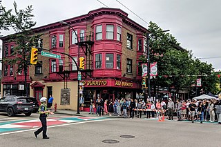
Little Italy is an area in the eastern part of Vancouver, British Columbia, Canada. It is in the Grandview–Woodland neighbourhood, and is often synonymous with the Commercial Drive area.

<span class="mw-page-title-main">Greater Vancouver</span> Metropolitan area in British Columbia, Canada

Greater Vancouver, also known as Metro Vancouver, is the metropolitan area with its major urban centre being the city of Vancouver, British Columbia, Canada. The term "Greater Vancouver" describes an area that is roughly coterminous with the region governed by the Metro Vancouver Regional District (MVRD), though it predates the 1966 creation of the regional district. It is often used to include areas beyond the boundaries of the regional district but does not generally include wilderness and agricultural areas that are included within the MVRD.

<span class="mw-page-title-main">Visible minority</span> Canadian demographic category

A visible minority is defined by the Government of Canada as "persons, other than aboriginal peoples, who are non-Caucasian in race or non-white in colour". The term is used primarily as a demographic category by Statistics Canada, in connection with that country's Employment Equity policies. The qualifier "visible" was chosen by the Canadian authorities as a way to single out newer immigrant minorities from both Aboriginal Canadians and other "older" minorities distinguishable by language and religion, which are "invisible" traits.

<span class="mw-page-title-main">Strathcona, Vancouver</span> Neighbourhood in Vancouver, Metro Vancouver

Strathcona is the oldest residential neighbourhood of Vancouver, British Columbia, Canada. Officially a part of the East Side, it is bordered by Downtown Vancouver's Chinatown neighbourhood and the False Creek inlet to the west, Downtown Eastside to the north, Grandview-Woodland to the east, and Mount Pleasant to the south of Emily Carr University and the Canadian National Railway and Great Northern Railway classification yards.

<span class="mw-page-title-main">Downtown Vancouver</span> Neighbourhood of Vancouver in British Columbia, Canada

Downtown Vancouver is the central business district and the city centre neighbourhood of Vancouver, Canada, on the northwestern shore of the Burrard Peninsula in the Lower Mainland region of British Columbia. It occupies most of the north shore of the False Creek inlet, which cuts into the Burrard Peninsula creating the Downtown Peninsula, where the West End neighbourhood and Stanley Park are also located.

The demographics of Metro Vancouver indicate a multicultural and multiracial region. Metro Vancouver is a metropolitan area, with its major urban centre being Vancouver, British Columbia, Canada. The Vancouver census metropolitan area, as defined by Statistics Canada, encompasses roughly the same territory as the Metro Vancouver Regional District, a regional district in British Columbia. The regional district includes 23 local authorities. Figures provided here are for the Vancouver census metropolitan area and not for the City of Vancouver.

<span class="mw-page-title-main">East Vancouver</span> Place in British Columbia, Canada

East Vancouver is a region within the city of Vancouver, British Columbia, Canada. Geographically, East Vancouver is bordered to the north by Burrard Inlet, to the south by the Fraser River, and to the east by the city of Burnaby. East Vancouver is divided from Vancouver's "West Side" by Ontario Street.

<span class="mw-page-title-main">Victoria–Fraserview</span> Neighbourhood in Vancouver, British Columbia, Canada

Victoria–Fraserview is a neighbourhood in the City of Vancouver, set on the south slope of the rise that runs north from the Fraser River and encompassing a large area of residential and commercial development. Surrounding the culturally eclectic Victoria Drive corridor, Victoria–Fraserview is an ethnically diverse area that was one of the earliest areas of settlement in the region.

<span class="mw-page-title-main">Ethnoburb</span> Urban area with a specific ethnic minority

An ethnoburb is a suburban residential and business area with a notable cluster of a particular ethnic minority population. Although the group may not constitute the majority within the region, it is a significant amount of the population. That can greatly influence the social geography within the area because of cultural and religious traditional values exhibited. Ethnoburbs allow for ethnic minority groups to maintain their individual identity, but that may also restrict their ability to fully assimilate into mainstream culture and society.

Ethnic succession theory is a theory in sociology stating that ethnic and racial groups entering a new area may settle in older neighborhoods or urban areas until achieving economic parity with certain economic classes. The concept of succession is well established in "both ecological and economic models of urban residential change." As the newer group becomes economically successful, it moves to a better residential area. With continued immigration, a new ethnic group will settle in the older neighborhood in a similar starting situation. This pattern will continue, creating a succession of groups moving through the neighborhood over time. Ethnic succession has taken place in most major United States cities, but is most well known in New York City, where this process has been observed since the 19th century.

Residential segregation is the physical separation of two or more groups into different neighborhoods—a form of segregation that "sorts population groups into various neighborhood contexts and shapes the living environment at the neighborhood level". While it has traditionally been associated with racial segregation, it generally refers to the separation of populations based on some criteria.

In the United States, housing segregation is the practice of denying African Americans and other minority groups equal access to housing through the process of misinformation, denial of realty and financing services, and racial steering. Housing policy in the United States has influenced housing segregation trends throughout history. Key legislation include the National Housing Act of 1934, the G.I. Bill, and the Fair Housing Act. Factors such as socioeconomic status, spatial assimilation, and immigration contribute to perpetuating housing segregation. The effects of housing segregation include relocation, unequal living standards, and poverty. However, there have been initiatives to combat housing segregation, such as the Section 8 housing program.

South Asian Canadians in Metro Vancouver are the third-largest pan-ethnic group in the region, comprising 369,295 persons or 14.2 percent of the total population as of 2021. Sizable communities exist within the city of Vancouver along with the adjoining city of Surrey, which houses one of the world's largest South Asian enclaves.

Chinese Canadians are a sizable part of the population in Greater Vancouver, especially in the Chinese communities in the city of Vancouver and the adjoining suburban city of Richmond. The legacy of Chinese immigration is prevalent throughout the Vancouver area.

<span class="mw-page-title-main">Chinatown, Toronto</span> Neighbourhood in Toronto, Ontario, Canada

Chinatown, Toronto is a Chinese ethnic enclave located in the city's downtown core of Toronto, Ontario, Canada. It is centred at the intersections of Spadina Avenue and Dundas Street West.

References

  1. 1 2 Ghettos in Canada's cities? Racial Segregation, ethnic enclaves and poverty concentration in Canadian urban areas P278
  2. Statistics Canada. 2003 Canada's Ethnocultural Portrait: The Changing Mosaic (Ottawa: Statistics Canada Census Analysis Series) Cat. 96F0030XIE2001008
  3. Government of Canada, Statistics Canada (2022-09-21). "Indigenous identity by Registered or Treaty Indian status: Canada, provinces and territories, census divisions and census subdivisions". www150.statcan.gc.ca. Retrieved 2022-11-04.
  4. Government of Canada, Statistics Canada (2022-10-26). "Visible minority and population group by generation status: Canada, provinces and territories, census metropolitan areas and census agglomerations with parts". www150.statcan.gc.ca. Retrieved 2022-11-04.
  5. 1 2 3 4 5 6 7 8 9 10 11 12 Bauder, Harald; Sharpe, Bob (September 2002). "Residential segregation of visible minorities in Canada's gateway cities" (PDF). The Canadian Geographer. 46 (3): 204–222. doi:10.1111/j.1541-0064.2002.tb00741.x. ProQuest   228301838.
  6. Hiebert, D. 1999. "Immigration and the changing social geography of greater Vancouver" BC Studies 121, 35-82
  7. 1 2 3 4 5 6 7 Balakrishnan, T R (2001). "Residential Segregation and Socio-economic Integration of Asians in Canadian Cities". Canadian Ethnic Studies. 33 (1). Calgary: 121. ProQuest   215637701.
  8. Public Transit Use Among Immigrants p.10
  9. 1 2 A History of Ethnic Enclaves in Canada. P8
  10. A History of Ethnic Enclaves in Canada. P9
  11. 1 2 Evenden, L. J. (1995). "Review of Vancouver's Chinatown: Racial Discourse in Canada, 1875-1980". Urban Studies. 32 (2): 427–428. JSTOR   43196276.
  12. 1 2 A Profile of First Nations, Tribal Councils, Treaty Groups and Associations with Interests within Metro Vancouver and Member Municipalities "Archived copy" (PDF). Archived from the original (PDF) on 2012-06-11. Retrieved 2012-11-05.{{cite web}}: CS1 maint: archived copy as title (link)
  13. Henry-Dixon, Natasha. "Racial Segregation of Black People in Canada". The Canadian Encyclopaedia. Retrieved 2 April 2024.
  14. "Racial Segregation of People in Canada – Housing and Employment". aeolianhall.ca. 8 October 2020. Retrieved 2 April 2024.
  15. Landau-Donnelly, Friederike (September 2023). "Ghostly murals: Tracing the politics of public art in Vancouver's Hogan's Alley". Environment and Planning C: Politics and Space. 41 (6): 1147–1165. doi: 10.1177/23996544231172122 . ISSN   2399-6544 . Retrieved 2 April 2024.