Reynolds County, Missouri

Last updated

Reynolds County
Reynolds County Missouri Courthouse-20150101-078.jpg
The antebellum county courthouse in Centerville
Map of Missouri highlighting Reynolds County.svg
Location within the U.S. state of Missouri
Missouri in United States.svg
Missouri's location within the U.S.
Coordinates: 37°22′N90°58′W / 37.36°N 90.97°W / 37.36; -90.97
CountryFlag of the United States.svg United States
StateFlag of Missouri.svg  Missouri
FoundedFebruary 25, 1845
Named for Thomas Reynolds
Seat Centerville
Largest city Ellington
Area
  Total814 sq mi (2,110 km2)
  Land808 sq mi (2,090 km2)
  Water5.9 sq mi (15 km2)  0.7%
Population
 (2020)
  Total6,096
  Density7.5/sq mi (2.9/km2)
Time zone UTC−6 (Central)
  Summer (DST) UTC−5 (CDT)
Congressional district 8th

Reynolds County is a county located in the Ozark Foothills Region in the Lead Belt of Missouri. As of the 2020 census, the population was 6,096. [1] Its county seat is Centerville. [2] The county was officially organized on February 25, 1845, and was named in honor of former Governor of Missouri Thomas Reynolds. [3]

Contents

The county is home to Johnson's Shut-Ins State Park, a popular tourist attraction in the state of Missouri.

History

Reynolds County was officially organized on February 25, 1845. It is still an area of rugged beauty near the geologic center of the Ozark Highland. Reynolds County was formerly part of Ripley County which was formed in 1831 and part of Wayne County which was formed in 1818. It was also previously part of Washington County and part of Ste. Genevieve County.

The Reynolds County Courthouse has burned twice. The first time was in December 1863 when the Confederate army burned it. A new courthouse was built in the fall of 1867 on the same foundation as the previous one. This courthouse was burned in late November 1871. Both times all records were destroyed. Temporary quarters again burned May 27, 1872, while a new "fireproof" courthouse was being built.

Geography

According to the U.S. Census Bureau, the county has a total area of 814 square miles (2,110 km2), of which 808 square miles (2,090 km2) is land and 5.9 square miles (15 km2) (0.7%) is water. [4]

Adjacent counties

Major highways

National protected area

Geographical features

Demographics

Historical population
CensusPop.Note
1850 1,849
1860 3,17371.6%
1870 3,75618.4%
1880 5,72252.3%
1890 6,80318.9%
1900 8,16120.0%
1910 9,59217.5%
1920 10,1065.4%
1930 8,923−11.7%
1940 9,3705.0%
1950 6,918−26.2%
1960 5,161−25.4%
1970 6,10618.3%
1980 7,23018.4%
1990 6,661−7.9%
2000 6,6890.4%
2010 6,6960.1%
2020 6,096−9.0%
U.S. Decennial Census [5]
1790-1960 [6] 1900-1990 [7]
1990-2000 [8] 2010-2015 [9]

As of the census [10] of 2000, there were 6,689 people, 2,721 households, and 1,915 families residing in the county. The population density was 8 people per square mile (3.1 people/km2). There were 3,759 housing units at an average density of 5 units per square mile (1.9/km2). The racial makeup of the county was 95.65% White, 0.52% Black or African American, 1.29% Native American, 0.19% Asian, 0.21% from other races, and 2.14% from two or more races. Approximately 0.82% of the population were Hispanic or Latino of any race. Among the major first ancestries reported in Reynolds County were 37.6% American, 12.1% Irish, 11.6% German, and 11.4% English.

There were 2,721 households, out of which 27.80% had children under the age of 18 living with them, 59.20% were married couples living together, 7.80% had a female householder with no husband present, and 29.60% were non-families. 26.00% of all households were made up of individuals, and 11.10% had someone living alone who was 65 years of age or older. The average household size was 2.40 and the average family size was 2.85.

In the county, the population was spread out, with 24.00% under the age of 18, 6.80% from 18 to 24, 25.00% from 25 to 44, 27.90% from 45 to 64, and 16.20% who were 65 years of age or older. The median age was 41 years. For every 100 females there were 101.60 males. For every 100 females age 18 and over, there were 98.60 males.

The median income for a household in the county was $31,546, and the median income for a family was $37,891. Males had a median income of $26,753 versus $18,322 for females. The per capita income for the county was $15,847. About 16.10% of families and 20.10% of the population were below the poverty line, including 25.90% of those under age 18 and 15.50% of those age 65 or over.

Religion

According to the Association of Religion Data Archives County Membership Report (2000), Reynolds County is a part of the Bible Belt with evangelical Protestantism being the majority religion. The most predominant denominations among residents in Reynolds County who adhere to a religion are Southern Baptists (78.80%), Baptist Missionary Association of America (8.24%), and Methodists (4.24%).

2020 Census

Reynolds County Racial Composition [11]
RaceNum.Perc.
White (NH)5,66993%
Black or African American (NH)330.54%
Native American (NH)230.38%
Asian (NH)180.3%
Pacific Islander (NH)20.03%
Other/Mixed (NH)2524.13%
Hispanic or Latino 991.62%

Politics

Local

The Democratic Party has the most elected officials at the local level in Reynolds.

Reynolds County, Missouri
Elected countywide officials
Assessor Rick Parker Democratic
Circuit Clerk Brandi Freeman Republican
County Clerk Mike Harper Democratic
Collector Denise Smith Republican
Commissioner
(Presiding)
Joe Loyd Republican
Commissioner
(District 1)
Larry Pogue Jr. Democratic
Commissioner
(District 2)
Eddie Williams Democratic
Coroner Jeffrey N. McSpadden Democratic
Prosecuting Attorney Ginger Joyner Democratic
Public Administrator Mallory Fox Democratic
Recorder Myra Turner Democratic
Sheriff Donald Horn Democratic
Surveyor Ronald Schwarz Democratic
Treasurer Wanda Corder Democratic

State

Reynolds County is divided into two legislative districts in the Missouri House of Representatives, both of which are held by Republicans.

Missouri House of Representatives — District 143 — Reynolds County (2016) [12]
PartyCandidateVotes%±%
Republican Jeffrey Pogue 287 100.00%
Missouri House of Representatives — District 143 — Reynolds County (2014)
PartyCandidateVotes%±%
Republican Jeffrey Pogue 161 100.00% +36.44
Missouri House of Representatives — District 143 — Reynolds County (2012)
PartyCandidateVotes%±%
Republican Jeffrey Pogue 225 63.56%
Democratic Shane Van Steenis12936.44%
Missouri House of Representatives — District 144 — Reynolds County (2016) [12]
PartyCandidateVotes%±%
Republican Paul Fitzwater 2,266 100.00%
Missouri House of Representatives — District 144 — Reynolds County (2014)
PartyCandidateVotes%±%
Republican Paul Fitzwater 1,167 100.00% +36.75
Missouri House of Representatives — District 144 — Reynolds County (2012)
PartyCandidateVotes%±%
Republican Paul Fitzwater 1,761 63.25%
Democratic Michael L. Jackson1,02336.75%

All of Reynolds County is a part of the 3rd District in the Missouri Senate and is currently represented by Gary Romine (R-Farmington).

Missouri Senate — District 3 — Reynolds County (2016) [12]
PartyCandidateVotes%±%
Republican Gary Romine 2,308 86.73% +26.93
Green Edward R. Weissler35313.27%+13.27
Missouri Senate — District 3 — Reynolds County (2012)
PartyCandidateVotes%±%
Republican Gary Romine 1,791 59.80%
Democratic Joseph Fallert, Jr.1,20440.20%
Past gubernatorial elections results
Year Republican Democratic Third Parties
2020 77.72%2,50119.67% 6332.61% 84
2016 66.30%1,96929.59% 8794.11% 122
2012 39.43% 1,23957.13%1,7953.44% 108
2008 37.73% 1,22358.65%1,9013.61% 117
2004 53.61%1,74645.13% 1,4701.25% 41
2000 46.29% 1,41648.38%1,4805.33% 163
1996 30.81% 88666.93%1,9252.26% 65
1992 32.39% 1,03467.61%2,1580.00% 0
1988 50.45%1,52849.19% 1,4900.36% 11
1984 39.46% 1,30860.54%2,0070.00% 0
1980 43.02% 1,38956.89%1,8370.09% 3
1976 39.71% 1,17560.19%1,7810.10% 3

Federal

United States presidential election results for Reynolds County, Missouri [13]
Year Republican Democratic Third party
No.%No.%No.%
2020 2,73382.87%52916.04%361.09%
2016 2,40679.20%54017.77%923.03%
2012 1,93160.31%1,15736.13%1143.56%
2008 1,78254.21%1,41843.14%872.65%
2004 1,89656.36%1,44943.07%190.56%
2000 1,76256.28%1,29841.46%712.27%
1996 90330.51%1,63155.10%42614.39%
1992 77623.34%2,01460.57%53516.09%
1988 1,16238.29%1,86461.42%90.30%
1984 1,33039.63%2,02660.37%00.00%
1980 1,27139.11%1,91959.05%601.85%
1976 87929.01%2,14370.73%80.26%
1972 1,54159.91%1,03140.09%00.00%
1968 89834.79%1,24548.24%43816.97%
1964 53022.41%1,83577.59%00.00%
1960 1,13952.18%1,04447.82%00.00%
1956 91736.49%1,59663.51%00.00%
1952 94930.82%2,12468.98%60.19%
1948 69225.18%2,05074.60%60.22%
1944 95133.57%1,87766.25%50.18%
1940 1,18732.97%2,40666.83%70.19%
1936 91526.94%2,47672.91%50.15%
1932 79224.35%2,43975.00%210.65%
1928 1,24743.99%1,58255.80%60.21%
1924 87332.05%1,82266.89%291.06%
1920 1,17338.51%1,83760.31%361.18%
1916 59232.02%1,20965.39%482.60%
1912 36722.19%1,03062.27%25715.54%
1908 54433.13%1,05264.07%462.80%
1904 50536.23%87762.91%120.86%
1900 45130.45%1,02769.35%30.20%
1896 38527.44%1,01572.34%30.21%
1892 28123.55%90375.69%90.75%
1888 25923.06%86276.76%20.18%
U.S. Senate — Missouri — Reynolds County (2016) [12]
PartyCandidateVotes%±%
Republican Roy Blunt 1,780 60.56% +21.17
Democratic Jason Kander1,00934.33%-19.37
Libertarian Jonathan Dine712.42%-4.50
Green Johnathan McFarland411.40%+1.40
Constitution Fred Ryman381.29%+1.29
U.S. Senate — Missouri — Reynolds County (2012)
PartyCandidateVotes%±%
Republican Todd Akin1,24739.39%
Democratic Claire McCaskill 1,700 53.70%
Libertarian Jonathan Dine2196.92%

Reynolds County is included in Missouri's 8th Congressional District and is currently represented by Jason T. Smith (R-Salem) in the U.S. House of Representatives. Smith won a special election on Tuesday, June 4, 2013, to finish out the remaining term of U.S. Representative Jo Ann Emerson (R-Cape Girardeau). Emerson announced her resignation a month after being reelected with over 70 percent of the vote in the district. She resigned to become CEO of the National Rural Electric Cooperative.

U.S. House of Representatives — Missouri's 8th Congressional District — Reynolds County (2016) [12]
PartyCandidateVotes%±%
Republican Jason T. Smith 2,236 77.34% +11.95
Democratic Dave Cowell58720.30%-6.20
Libertarian Jonathan Shell682.35%+1.07
U.S. House of Representatives — Missouri's 8th Congressional District — Reynolds County (2014)
PartyCandidateVotes%±%
Republican Jason T. Smith 1,024 65.39% +15.31
Democratic Barbara Stocker41526.50%-3.62
Libertarian Rick Vandeven201.28-0.02
Constitution Doug Enyart543.45%+3.45
Independent Terry Hampton533.38%+3.38
U.S. House of Representatives — Missouri's 8th Congressional District — Reynolds County (Special Election 2013)
PartyCandidateVotes%±%
Republican Jason T. Smith 451 64.99% -7.85
Democratic Steve Hodges20930.12%+5.14
Constitution Doug Enyart253.60%+3.60
Libertarian Bill Slantz91.30%-0.88
U.S. House of Representatives — Missouri's 8th Congressional District — Reynolds County (2012)
PartyCandidateVotes%±%
Republican Jo Ann Emerson 2,301 72.84%
Democratic Jack Rushin78924.98%
Libertarian Rick Vandeven692.18%

Political culture

At the presidential level, Reynolds County was a Democratic stronghold from its founding in 1845 through 1996; its only Republican votes (or indeed votes for any but the Democratic nominee) in this period were for Richard Nixon in 1960 and then again for Nixon in his 1972 landslide. [14] In 2000, George W. Bush carried the county for the Republican Party for only the third time ever, despite his narrow national popular vote defeat that year. The county has voted Republican in every subsequent election as of 2020, with the Republican vote share declining only in 2008. The Republican vote share has not been held below 60% since 2008.

Like most rural areas throughout Southeast Missouri, voters in Reynolds County generally adhere to socially and culturally conservative principles but are more moderate or populist on economic issues, typical of the Dixiecrat philosophy. In 2004, Missourians voted on a constitutional amendment to define marriage as the union between a man and a woman—it overwhelmingly passed Reynolds County with 85.41 percent of the vote. The initiative passed the state with 71 percent of support from voters as Missouri became the first state to ban same-sex marriage. In 2006, Missourians voted on a constitutional amendment to fund and legalize embryonic stem cell research in the state—it failed in Reynolds County with 54.15 percent voting against the measure. The initiative narrowly passed the state with 51 percent of support from voters as Missouri became one of the first states in the nation to approve embryonic stem cell research. Despite Reynolds County's longstanding tradition of supporting socially conservative platforms, voters in the county have a penchant for advancing populist causes like increasing the minimum wage. In 2006, Missourians voted on a proposition (Proposition B) to increase the minimum wage in the state to $6.50 an hour—it passed Reynolds County with 77.50 percent of the vote. The proposition strongly passed every single county in Missouri with 75.94 percent voting in favor as the minimum wage was increased to $6.50 an hour in the state. During the same election, voters in five other states also strongly approved increases in the minimum wage.

Missouri presidential preference primary (2008)

In the 2008 presidential primary, voters in Reynolds County from both political parties supported candidates who finished in second place in the state at large and nationally. Former U.S. Senator Hillary Clinton (D-New York) received more votes, a total of 741, than any candidate from either party in Reynolds County during the 2008 presidential primary. She also received more votes than the total number of votes cast in the entire Republican Primary in Reynolds County.

Education

Of adults 25 years of age and older in Reynolds County, 40.4% possesses a high school diploma or higher while 10.0% holds a bachelor's degree or higher as their highest educational attainment.

Public schools

Public libraries

Communities

Cities

Unincorporated communities

See also

Related Research Articles

<span class="mw-page-title-main">Wright County, Missouri</span> County in Missouri, United States

Wright County is a county located in the southern portion of the U.S. state of Missouri. As of the 2020 census, the population was 18,188. Its county seat is Hartville. The county was officially organized on January 29, 1841, and is named after Silas Wright, a former Congressman, U.S. Senator and Governor of New York.

<span class="mw-page-title-main">Webster County, Missouri</span> County in Missouri, United States

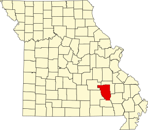
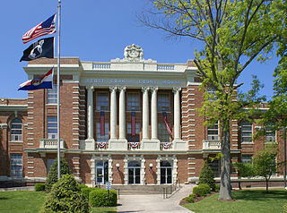
Webster County is a county located in the U.S. state of Missouri. As of the 2020 census, the population was 39,085. Its county seat is Marshfield. The county was organized in 1855 and named for U.S. Senator and U.S. Secretary of State Daniel Webster.

<span class="mw-page-title-main">Wayne County, Missouri</span> County in Missouri, United States

Wayne County is a county located in the Ozark foothills in the U.S. state of Missouri. As of the 2020 census, the population was 10,974. The county seat is Greenville. The county was officially organized on December 11, 1818, and is named after General "Mad" Anthony Wayne, who served in the American Revolution. As of August 28, 2023, Wayne County is designated the UFO Capital of Missouri, along with the city of Piedmont.

<span class="mw-page-title-main">Warren County, Missouri</span> County in Missouri, United States

Warren County is a county located in the eastern portion of the U.S. state of Missouri. As of the 2020 census, the population was 35,532. The county is located on the north side of the Missouri River. Its county seat is Warrenton. The county was established on January 5, 1833, and was named for General Joseph Warren, who died in the Battle of Bunker Hill during the American Revolutionary War.

<span class="mw-page-title-main">Texas County, Missouri</span> County in Missouri, United States

Texas County is a county located in the southern portion of the U.S. state of Missouri. As of the 2020 census, the population was 24,487. Its county seat is Houston. The county was organized in 1843 as Ashley County. Its name was changed in 1845 to Texas County, after the Republic of Texas. The 2010 U.S. Census indicates that the county was the center of population for the United States.

<span class="mw-page-title-main">Taney County, Missouri</span> County in Missouri, United States

Taney County is a county in the southwestern portion of the U.S. state of Missouri. As of the 2020 census, the population was 56,066. Its county seat is Forsyth. It is included in the Branson, Missouri, Micropolitan Statistical Area.

<span class="mw-page-title-main">Stone County, Missouri</span> County in Missouri, United States

Stone County is located in the southwestern portion of the U.S. state of Missouri. As of the 2020 census, the population was 31,076. Its county seat is Galena.

<span class="mw-page-title-main">Stoddard County, Missouri</span> County in Missouri, United States

Stoddard County is a county located in the southeastern portion of the U.S. state of Missouri. As of the 2020 census, the population was 28,672. The county seat is Bloomfield. The county was officially organized on January 2, 1835, and is named for Amos Stoddard, the first American commandant of Upper Louisiana.

<span class="mw-page-title-main">Ste. Genevieve County, Missouri</span> County in Missouri, United States

Sainte Genevieve County, often abbreviated Ste. Genevieve County, is a county located in the eastern portion of the U.S. state of Missouri. As of the 2020 census, the population was 18,479. The largest city and county seat is Ste. Genevieve. The county was officially organized on October 1, 1812, and is named after the Spanish district once located in the region, after Saint Genevieve, patroness of Paris, France.

<span class="mw-page-title-main">Shannon County, Missouri</span> County in Missouri, United States

Shannon County is a county in the southern portion of the U.S. state of Missouri. As of the 2020 census, the population was 7,031. Its county seat is Eminence. The county was officially organized on January 29, 1841, and was named in honor of George F. "Peg-Leg" Shannon, a member of the Lewis and Clark Expedition. It is the second-largest county by area in Missouri.

<span class="mw-page-title-main">Scott County, Missouri</span> County in Missouri, United States

Scott County is located in the southeastern portion of the U.S. state of Missouri. As of the 2020 census, the population was 38,059. Its county seat is Benton. The county was organized in 1821 and named for U.S. Representative John Scott, the first federal representative from Missouri. Scott County comprises the Sikeston, MO Micropolitan Statistical Area, which is also included in the Cape Girardeau-Sikeston, MO-IL Combined Statistical Area. The county is home to Scott County Central High School, which has won 18 state championships in boys basketball—the most of any high school in the state.

<span class="mw-page-title-main">Ripley County, Missouri</span> County in Missouri, United States

Ripley County is a county in the Ozarks of Missouri. At the 2020 census, it had a population of 10,679. The largest city and county seat is Doniphan. The county was officially organized on January 5, 1833, and is named after Brigadier General Eleazer Wheelock Ripley, a soldier who served with distinction in the War of 1812.

<span class="mw-page-title-main">Pemiscot County, Missouri</span> County in Missouri, United States

Pemiscot County is a county located in the southeastern corner in the Bootheel in the U.S. state of Missouri, with the Mississippi River forming its eastern border. As of the 2020 census, the population was 15,661. The largest city and county seat is Caruthersville. The county was officially organized on February 19, 1851. It is named for the local bayou, taken from the word pem-eskaw, meaning "liquid mud", in the language of the native Fox (Meskwaki) people. This has been an area of cotton plantations and later other commodity crops.

<span class="mw-page-title-main">Ozark County, Missouri</span> County in Missouri, United States

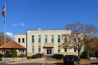
Ozark County is a county in the southern portion of the U.S. state of Missouri. As of the 2020 census, the population was 8,553. The largest city and county seat is Gainesville. The county was organized as Ozark County, named after the Ozark Mountains, on January 29, 1841. It was renamed Decatur County, after Commodore Stephen Decatur, from 1843 to 1845, after which the name Ozark County was restored.

<span class="mw-page-title-main">Oregon County, Missouri</span> County in Missouri

Oregon County is a county located in the southern portion of the U.S. state of Missouri. As of the 2020 census, the population was 8,635. Its county seat is Alton. The county was officially organized on February 14, 1845, and was named for the Oregon Territory in the northwestern United States.

<span class="mw-page-title-main">McDonald County, Missouri</span> County in Missouri, United States

McDonald County is a county located in the southwestern corner of the U.S. state of Missouri. As of the 2020 census, the population was 23,303. Its county seat is Pineville. The county was organized in 1849 and named for Sergeant Alexander McDonald, a soldier in the American Revolutionary War. The county has three sites on the National Register of Historic Places, including the Old McDonald County Courthouse and the Powell Bridge.

<span class="mw-page-title-main">Iron County, Missouri</span> County in Missouri, United States

Iron County is a county located in the Lead Belt region in the U.S. state of Missouri. As of the 2020 census, the population was 9,537. The largest city and county seat is Ironton. Iron County was officially organized on February 17, 1857, and was named after the abundance of iron ore found within its borders.

<span class="mw-page-title-main">Howell County, Missouri</span> County in Missouri, United States

Howell County is in southern Missouri. As of the 2020 census, the population was 39,750. The largest city and county seat is West Plains. The county was officially organized on March 2, 1851, and is named after Josiah Howell, a pioneer settler in the Howell Valley.

<span class="mw-page-title-main">Douglas County, Missouri</span> County in Missouri, United States

Douglas County is a county located in the south-central portion of the U.S. state of Missouri. As of the 2020 census, the population was 11,578. The county seat and only incorporated community is Ava. The county was officially organized on October 19, 1857, and is named after U.S. Senator Stephen A. Douglas (D-Illinois) and later Democratic presidential candidate.

<span class="mw-page-title-main">Dent County, Missouri</span> County in Missouri, United States

Dent County is a county in Missouri. As of the 2020 census, the population was 14,421. The largest city and county seat is Salem. The county was officially organized on February 10, 1851, and is named after state representative Lewis Dent, a pioneer settler who arrived in Missouri from Virginia in 1835.

References

  1. "Explore Census Data". data.census.gov. Retrieved December 20, 2021.
  2. "Find a County". National Association of Counties. Retrieved June 7, 2011.
  3. Eaton, David Wolfe (1917). How Missouri Counties, Towns and Streams Were Named. The State Historical Society of Missouri. pp.  347.
  4. "2010 Census Gazetteer Files". United States Census Bureau. August 22, 2012. Archived from the original on October 21, 2013. Retrieved November 18, 2014.
  5. "U.S. Decennial Census". United States Census Bureau. Retrieved November 18, 2014.
  6. "Historical Census Browser". University of Virginia Library. Retrieved November 18, 2014.
  7. "Population of Counties by Decennial Census: 1900 to 1990". United States Census Bureau. Retrieved November 18, 2014.
  8. "Census 2000 PHC-T-4. Ranking Tables for Counties: 1990 and 2000" (PDF). United States Census Bureau. Archived (PDF) from the original on March 27, 2010. Retrieved November 18, 2014.
  9. "State & County QuickFacts". United States Census Bureau. Archived from the original on June 7, 2011. Retrieved September 12, 2013.
  10. "U.S. Census website". United States Census Bureau . Retrieved January 31, 2008.
  11. "P2 HISPANIC OR LATINO, AND NOT HISPANIC OR LATINO BY RACE – 2020: DEC Redistricting Data (PL 94-171) – Reynolds County, Missouri".
  12. 1 2 3 4 5 "County Results - State of Missouri - 2016 General Election, November 8, 2016 - Official Results". Missouri Secretary of State. December 12, 2016. Retrieved May 10, 2017.
  13. Leip, David. "Dave Leip's Atlas of U.S. Presidential Elections". uselectionatlas.org. Retrieved March 26, 2018.
  14. "County winners, 1836-2016". Google Docs. Retrieved January 13, 2021.
  15. Breeding, Marshall. "Reynolds County Library District". Libraries.org. Retrieved May 8, 2017.

37°22′N90°58′W / 37.36°N 90.97°W / 37.36; -90.97