Riberalta

Last updated
Riberalta
Town and municipality
507 - ...big red town.jpg
Riberalta, Bolivia
Bolivia adm location map.svg
Red pog.svg
Riberalta
Location of Riberalta town in Bolivia
Coordinates: 10°59′S66°6′W / 10.983°S 66.100°W / -10.983; -66.100
CountryBandera de Bolivia (Estado).svg  Bolivia
Department Beni Department
Province Vaca Díez Province
Settled1897
Area
  Total20.1 km2 (7.8 sq mi)
Elevation
144 m (472 ft)
Population
 (2018)
  Total99,070
  Density4,900/km2 (13,000/sq mi)
Time zone UTC-4 (BOT)
Area code +591 2
Website Official website

Riberalta is a town in the Beni Department in northern Bolivia, situated where the Madre de Dios River joins the Beni River. Riberalta is on the south (south east) bank of the Beni River.

Contents

As the capital of the province of Vaca Diez, the city has maintained its charm even after the Brazilian nut trade sparked recent development. Bolivia is the dominant producer of the nuts, in the period 2017/2018, the country accounted for 78% of production. Peru producers 16% while Brazil produces a mere 2%. [1] City life in Riberalta Municipality [2] is punctuated by nature thanks to its location on the banks of the Beni and Madre de Dios rivers and its proximity to the Amazon rainforest. Home to the Bolivian Navy flotilla and the 1st Naval District, the city is also called the Bolivian capital of the Amazon.

History

Riberalta was originally inhabited by the Chácobo and Pacahuara natives who called it “Pamahuayá”, which means “place of the fruits”. Bolivian anthropologist Wigberto Rivero [3] determined that the area was once populated by indigenous groups of the Pano family; which belong to the native Pacahuara, Chacobos, Caripunas, Sinabos and Perintintin. These same people lived for thousands of years resisting attacks from the Incan Empire and western settlers.

Riberalta’s current name comes from the union of two words in Spanish: “ribera alta” (“high bank” in English.) The city was founded on February 3, 1894 with approximately 2,500 inhabitants established in a red canyon in Northern Bolivia.

It is also known as the city of four names: Barranca Colorada (Red Canyon), La Cruz (The Cross), Ribera-Alta (High Bank), and Riberalta. [4] Starting in the middle of the 19th century, solo explorers and navigators of the Bolivian Northwest penetrated the solitary jungle; They founded barracks more than thirty meters high, erected and blessed by the convergence of two colossal rivers, which turned the municipality into the economic center of the north of the country.

On October 8, 1880, Don Edwin Heath named the city Barranca Colorada. A few years later Frederico Bodo Claussen, manager of House Braillard de Reyes, was informed of the barracks and sent a German subject with resources to install a commercial factory there. [5] Afterwards, it received the name La Cruz on May 3, 1884 when Don Maximo Henicke surveyed a small home built two years earlier in 1882 by Placido Mendez. A little over a year later, on July 7 of 1885, Bodo Claussen baptized the city under the name Ribera-Alta, which later was combined into Riberalta. Nine years later, on February 3 of 1894, Riberalta was founded with an official act under the name Villa Riberalta, after having already existed for twelve years. [6] It was founded by a National Delegate of the Colonies, Lysimachus Gutiérrez, who did so under the orders of President Mariano Baptista and in honor of the birth of the Mcal. Antonio Jose de Sucre.

Climate

Riberalta belongs to a transition zone between the tropical savanna climate of the Llanos de Moxos and the tropical monsoon climate of the southwestern amazon rainforest. Precipitation is moderately high, but divided starkly between seasons. According to the Köppen Climate Classification system, Riberalta has a tropical savanna climate, abbreviated "Aw" on climate maps, with a pronounced wet and dry season. [7]

Climate data for Riberalta, Bolivia
MonthJanFebMarAprMayJunJulAugSepOctNovDecYear
Record high °C (°F)35.0
(95.0)
35.0
(95.0)
36.0
(96.8)
34.6
(94.3)
35.8
(96.4)
33.3
(91.9)
34.2
(93.6)
36.4
(97.5)
38.3
(100.9)
36.5
(97.7)
36.0
(96.8)
36.8
(98.2)
38.3
(100.9)
Mean daily maximum °C (°F)30.2
(86.4)
30.8
(87.4)
31.5
(88.7)
30.7
(87.3)
29.4
(84.9)
30.1
(86.2)
30.5
(86.9)
32.1
(89.8)
33.3
(91.9)
32.2
(90.0)
31.3
(88.3)
31.3
(88.3)
31.1
(88.0)
Daily mean °C (°F)27.1
(80.8)
27.0
(80.6)
27.1
(80.8)
26.8
(80.2)
26.4
(79.5)
25.6
(78.1)
25.7
(78.3)
27.3
(81.1)
28.2
(82.8)
28.1
(82.6)
27.7
(81.9)
27.3
(81.1)
27.0
(80.6)
Mean daily minimum °C (°F)22.3
(72.1)
22.4
(72.3)
21.7
(71.1)
21.4
(70.5)
18.7
(65.7)
16.8
(62.2)
17.5
(63.5)
18.4
(65.1)
20.3
(68.5)
21.5
(70.7)
21.6
(70.9)
21.8
(71.2)
20.4
(68.7)
Record low °C (°F)20.6
(69.1)
20.0
(68.0)
17.2
(63.0)
15.0
(59.0)
10.0
(50.0)
9.9
(49.8)
8.9
(48.0)
10.0
(50.0)
13.8
(56.8)
16.1
(61.0)
16.0
(60.8)
19.0
(66.2)
8.9
(48.0)
Average precipitation mm (inches)320.8
(12.63)
295.1
(11.62)
287.8
(11.33)
149.3
(5.88)
103.6
(4.08)
27.7
(1.09)
7.8
(0.31)
32.1
(1.26)
82.2
(3.24)
152.8
(6.02)
197.2
(7.76)
232.0
(9.13)
1,888.3
(74.34)
Average precipitation days (≥ 0.1 mm)1717181373225101216122
Average relative humidity (%)79808081787670686872768076
Source: Deutscher Wetterdienst [8]

Transportation

Riberalta is connected to Cobija by bus and to the rest of Bolivia through the Capitán Av. Selin Zeitun Lopez Airport (RIB) , Northern Bolivia.

See also

Related Research Articles

<span class="mw-page-title-main">Amazon rainforest</span> Large rainforest in South America

The Amazon rainforest, also called Amazon jungle or Amazonia, is a moist broadleaf tropical rainforest in the Amazon biome that covers most of the Amazon basin of South America. This basin encompasses 7,000,000 km2 (2,700,000 sq mi), of which 5,500,000 km2 (2,100,000 sq mi) are covered by the rainforest. This region includes territory belonging to nine nations and 3,344 formally acknowledged indigenous territories.

<span class="mw-page-title-main">Geography of Bolivia</span>

The geography of Bolivia includes the Eastern Andes Mountain Range which bisects Bolivia roughly from north to south. To the east of that mountain chain are lowland plains of the Amazon Basin, and to the west is the Altiplano which is a highland plateau where Lake Titicaca is located. Bolivia's geography has features similar to those of Peru which abuts Bolivia's northwest border; like Bolivia, Peru is bisected from north to south by the Eastern Andes Mountains, and these two countries share Lake Titicaca which is the highest navigable lake on Earth. Unlike Peru, however, Bolivia is one of the two landlocked countries in South America, the other being Paraguay which is located along Bolivia's southeast border.

<span class="mw-page-title-main">Acre (state)</span> State of Brazil

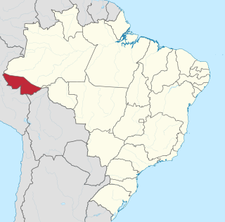
Acre ( ) is a state located in the west of the North Region of Brazil and the Amazonia Legal. Located in the westernmost part of the country, at a two-hour time difference from Brasília, Acre is bordered clockwise by the Brazilian states of Amazonas and Rondônia to the north and east, along with an international border with the Bolivian department of Pando to the southeast, and the Peruvian regions of Madre de Dios, Ucayali and Loreto to the south and west. Its capital and largest city is Rio Branco. Other important places include Cruzeiro do Sul, Sena Madureira, Tarauacá and Feijó. The state, which has 0.42% of the Brazilian population, generates 0.2% of the Brazilian GDP.

<span class="mw-page-title-main">Beni Department</span> Department of northeastern Bolivia

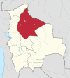
Beni, sometimes El Beni, is a northeastern department of Bolivia, in the lowlands region of the country. It is the second-largest department in the country, covering 213,564 square kilometers, and it was created by supreme decree on November 18, 1842, during the administration of General José Ballivián. Its capital is Trinidad.

<span class="mw-page-title-main">Pando Department</span> Department of Bolivia

Pando is a department in Northern Bolivia, with an area of 63,827 square kilometres (24,644 sq mi), in the Amazon Rainforest, adjoining the border with Brazil and Perú. Pando has a population of 154,355. Its capital is the city of Cobija.

<span class="mw-page-title-main">Department of Madre de Dios</span> Departments of Peru

Madre de Dios is a department and region in southeastern Peru, bordering Brazil, Bolivia and the Peruvian departments of Puno, Cusco and Ucayali, in the Amazon Basin. Its capital is the city of Puerto Maldonado. It is also the third largest department in Peru, after Ucayali and Loreto. However, it is also the least densely populated department in Peru, as well as its least populous department. It has one of the lowest poverty rates in Peru.

<span class="mw-page-title-main">Madre de Dios River</span> River in Peru and Bolivia

The Madre de Dios River is a river shared by Bolivia and Peru which is homonymous to the Peruvian region it runs through. On Bolivian territory, it receives the Beni River, close to the town of Riberalta, which later joins with the Mamore River to become the Madeira River after the confluence. The Madeira is a tributary to the Amazon River.

<span class="mw-page-title-main">Puerto Maldonado</span> Place in Madre de Dios, Peru

Puerto Maldonado is a city in southeastern Peru in the Amazon rainforest 55 kilometres (34 mi) west of the Bolivian border, located at the confluence of the Tambopata and Madre de Dios rivers. The latter river joins the Madeira River as a tributary of the Amazon. This city is the capital of the Department of Madre de Dios.

<span class="mw-page-title-main">Beni River</span> River in Bolivia, Brazil

The Beni River is a river in the north of Bolivia.

<span class="mw-page-title-main">Cobija</span> City in Pando Department, Bolivia

Cobija is a city in Bolivia, capital of the department of Pando, and is located about 600 km (373 mi.) north of La Paz in the Amazon Basin on the border with Brazil. Cobija lies on the banks of the Rio Acre across from the Brazilian city of Brasiléia. Cobija lies at an elevation of ca. 280 m (920 ft.) above sea level and has a tropical and rainy climate.

<span class="mw-page-title-main">Nicolás Suárez Callaú</span>

Nicolás Suárez Callaú set up a multinational rubber empire in South America at the beginning of the 20th century.

<span class="mw-page-title-main">Amazon rubber cycle</span> Historical period of Brazil (1879 to 1912)

The Amazon rubber cycle or boom was an important part of the economic and social history of Brazil and Amazonian regions of neighboring countries, being related to the extraction and commercialization of rubber. Centered in the Amazon Basin, the boom resulted in a large expansion of colonization in the area, attracting immigrant workers, generating wealth, causing cultural and social transformations, and disrupting local indigenous societies.

<span class="mw-page-title-main">Riberalta Airport</span> Airport in Bolivia

Capitán Av. Selin Zeitun Lopez Airport is an airport serving Riberalta, a port city on the Beni River in the Beni Department of Bolivia. The airport is in the western section of the city, near the confluence of the Beni and Madre de Dios Rivers.

<span class="mw-page-title-main">Tambopata River</span> River in Bolivia, Peru

The Tambopata River is a river in southeastern Peru and northwestern Bolivia. Most of the Tambopata is in the Madre de Dios and Puno regions in Peru, but the upper parts of the river forms the border between Peru and Bolivia, and its origin is in La Paz department in Bolivia. The Tambopata is a tributary of the Madre de Dios River, into which it merges at the city of Puerto Maldonado. The river flows through the Tambopata National Reserve.

<span class="mw-page-title-main">Carlos Fitzcarrald</span> Peruvian rubber baron (1862–1897)

Carlos Fermín Fitzcarrald López was a Peruvian rubber baron. He was born in San Luis, Ancash, in a province that was later named after him. In the early 1890s, Fitzcarrald discovered the Isthmus of Fitzcarrald, which was a portage route from the Ucayali River into the Madre de Dios River basin. Fitzcarrald became known as the "King of Caucho" due to his success during the rubber boom. His enterprise exploited and enslaved Asháninka, Mashco-Piro, Harákmbut, Shipibo-Conibo and other native groups, who were then dedicated to the extraction of rubber. In 1897, Fitzcarrald, along with his Bolivian business partner Antonio Vaca Díez, drowned in an accident on the Urubamba River.

Ese Ejja, also known as Tiatinagua (Tatinawa), is a Tacanan language of Bolivia and Peru. It is spoken by Ese Ejja people of all ages. Dialects are Guacanawa (Guarayo/Huarayo), Baguaja, Echoja, and possibly extinct Chama, Chuncho, Huanayo, Kinaki, and Mohino. Chunene is "similar" to Ese Ejja, though whether a dialect or a separate language is not clear.

Pacahuara people are an indigenous people of Bolivia. A small group live in Tujuré, a community located near the Chácobo people on the Alto Ivón River in the Beni Department. The group only consists of four people. The fifth, a 57-year-old woman, died on 31 December 2016 in the village of Tujure in the north-east of the country. Another uncontacted group of Pacahuara, with 50 members in eight families, lives between Rio Negro and Río Pacajuaras in the Pando of northeastern Bolivia, near the Brazilian border.

<span class="mw-page-title-main">Las Piedras River (Peru)</span> River in Peru

The Las Piedras River is a major tributary of the Madre de Dios River in the southeast Peruvian Amazon.

The Aquicuana Municipal Reserve is a protected natural reserve located about 20 km from the city of Riberalta in the Beni department in northern Bolivia and in the Amazon. It is home to Lake San José, a medicinal retreat center, Pistahua, and two communities, San José and Warnes. Its name, Aquicuana, comes from the ancestral name of the lake which was before named Aquicuana in the Tacana language and means the place of big trees.

<span class="mw-page-title-main">Cavineño people</span>

The Cavineño People are an ethnic group in Bolivia. They mainly live along the Beni and Madidi rivers. There were 3,884 of them in 2012 of whom 1,173 speak the Cavineña language natively. Almost all of them speak Spanish as well. According to Alfred Métraux the Cavineño and the Araona people are so intermixed with other Takanan-speaking peoples that it can be difficult to treat them separately.

References

  1. World Atlas
  2. Municipalities of Bolivia at www.editorialox.com
  3. Sieder, Rachel (2002). Multiculturalism in Latin America: Indigenous Rights, Diversity and Democracy. New York: Palgrave Macmillan. p. 70. ISBN   978-1-4039-3782-7.
  4. Lougheed, Vivien (2004). Bolivia Adventure Guide. Edison, NJ: Hunter. p. 514. ISBN   978-1588433657.
  5. Fifer, J. Valerie (1970). "The Empire Builders: A History of the Bolivian Rubber Boom and the Rise of the House of Suarez". Journal of Latin American Studies. 2 (2): 113–146. doi:10.1017/S0022216X00005095. JSTOR   156583.
  6. Vallve, Frederic (January 22, 2010). "The Impact of the Rubber Boom on the Indigenous Peoples of the Bolivian Lowlands" (PDF). Georgetown University: 112. Retrieved March 5, 2017.
  7. Climate Summary for Riberalta
  8. "Klimatafel von Riberalta, Prov. Pando / Bolivien" (PDF). Baseline climate means (1961-1990) from stations all over the world (in German). Deutscher Wetterdienst. Retrieved 27 January 2016.

11°0′46″S66°3′26″W / 11.01278°S 66.05722°W / -11.01278; -66.05722