The Southern Alps are a mountain range extending along much of the length of New Zealand's South Island, reaching its greatest elevations near the range's western side. The name "Southern Alps" generally refers to the entire range, although separate names are given to many of the smaller ranges that form part of it.

Fiordland is a geographical region of New Zealand in the south-western corner of the South Island, comprising the westernmost third of Southland. Most of Fiordland is dominated by the steep sides of the snow-capped Southern Alps, deep lakes, and its steep, glacier-carved and now ocean-flooded western valleys. The name "Fiordland" comes from a variant spelling of the Scandinavian word for this type of steep valley, "fjord". The area of Fiordland is dominated by, and very roughly coterminous with, Fiordland National Park, New Zealand's largest National Park.

The Valdivian temperate forests (NT0404) is an ecoregion on the west coast of southern South America, in Chile and Argentina. It is part of the Neotropical realm. The forests are named after the city of Valdivia. The Valdivian temperate rainforests are characterized by their dense understories of bamboos, ferns, and for being mostly dominated by evergreen angiosperm trees with some deciduous specimens, though conifer trees are also common.

The Magellanic subpolar forests are a terrestrial ecoregion of southernmost South America, covering parts of southern Chile and Argentina, and are part of the Neotropical realm. It is a temperate broadleaf and mixed forests ecoregion, and contains the world's southernmost forests.

Temperate rainforests are rainforests with coniferous or broadleaf forests that occur in the temperate zone and receive heavy rain.

The Kaikōura Ranges are two parallel ranges of mountains located in the northeast of the South Island of New Zealand. The two ranges are visible from a great distance, including from the southern coast of the North Island.

The New Caledonia rain forests are a terrestrial ecoregion, located in New Caledonia in the South Pacific. It is a tropical moist broadleaf forest ecoregion, part of the Australasian realm.

Giant wētā are several species of wētā in the genus Deinacrida of the family Anostostomatidae. Giant wētā are endemic to New Zealand and all but one species are protected by law because they are considered at risk of extinction.

Deinacrida heteracantha, also known as the Little Barrier giant wētā or wētāpunga, is a wētā in the order Orthoptera and family Anostostomatidae. It is endemic to New Zealand, where it survived only on Little Barrier Island, although it has been translocated to some other predator-free island conservation areas. This very large flightless wētā mainly feeds at night, but is also active during the day, when it can be found above ground in vegetation. It has been classified as vulnerable by the IUCN due to ongoing population declines and restricted distribution.

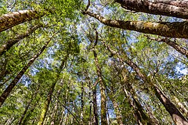
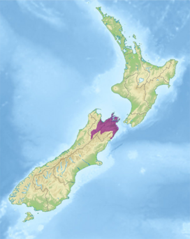
Deinacrida parva is a species of insect in the family Anostostomatidae, the king crickets and weta. It is known commonly as the Kaikoura wētā or Kaikoura giant wētā. It was first described in 1894 from a male individual then rediscovered in 1966 by Dr J.C. Watt at Lake Sedgemore in Upper Wairau. It is endemic to New Zealand, where it can be found in the northern half of the South Island.

The New Guinea Highlands, also known as the Central Range or Central Cordillera, is a long chain of mountain ranges on the island of New Guinea, including the island's tallest peak, Puncak Jaya, Indonesia, 16,024 ft (4,884 m), the highest mountain in Oceania. The range is home to many intermountain river valleys, many of which support thriving agricultural communities. The highlands run generally east-west the length of the island, which is divided politically between Indonesia in the west and Papua New Guinea in the east.

The Chilean Matorral (NT1201) is a terrestrial ecoregion of central Chile, located on the west coast of South America. It is in the Mediterranean forests, woodlands, and scrub biome, part of the Neotropical realm.

The Central Range montane rain forests is a tropical moist forest ecoregion on the island of New Guinea. The ecoregion covers the Central Range of the New Guinea Highlands, which extends along the spine of the island. The montane rain forests of the ecoregion are distinct from the surrounding lowland forests, and are home to many endemic plants and animals.

The Nelson Coast temperate forests is an ecoregion in New Zealand.

The North Island temperate forests, also known as the Northland temperate forests, is a temperate broadleaf and mixed forests ecoregion on New Zealand’s North Island.

The Northland temperate kauri forests is an ecoregion in northern New Zealand, within the temperate broadleaf and mixed forests biome.

The Canterbury-Otago tussock grasslands is an ecoregion of the South Island, New Zealand, part of the wider tussock grasslands of New Zealand.

The Southland montane grasslands, also known as the South Island montane grasslands, is a montane grasslands and shrublands ecoregion on New Zealand’s South Island. The ecoregion covers the middle portion of the Southern Alps, and includes extensive alpine grasslands, fellfields, and montane forests.

Deinacrida elegans is a species of wētā in family Anostostomatidae. It is endemic to New Zealand.

The Southland temperate forests is a temperate broadleaf and mixed forests ecoregion on New Zealand's South Island. The natural vegetation was mostly forest, but over the centuries human activities, including grazing and fires, replaced much of the original forest with grassland and agriculture.