River Carron, Forth

Last updated

The Carron at its confluence with the Garvald Burn, near Fankerton. River Carron (geograph 2268831).jpg
The Carron at its confluence with the Garvald Burn, near Fankerton.

The Carron (Gaelic: Carrann) is a river in central Scotland, rising in the Campsie Fells [1] and flowing along Strathcarron into the Firth of Forth. It has given its name to several locations in Stirlingshire, as well as a type of cannon, a line of bathtubs, two warships, and an island in the Southern Hemisphere.

Contents

Course

The Carron at Glensburgh, close to its mouth. River Carron at Glensburgh (geograph 4052194).jpg
The Carron at Glensburgh, close to its mouth.

The river rises in the Campsie Fells before flowing into the Carron Reservoir and along Strathcarron. It passes by Denny, then between Larbert [2] and Falkirk, then past Carron village. Just as the M9 motorway crosses the river, the Forth and Clyde canal joins the river. It then flows into the Forth near Grangemouth. [1] [3] The tributary water sources are: Carron Reservoir, Avon Burn, Earl’s Burn, Auchenbowie Burn, Loch Coulter Reservoir, Bonny Water, Glencryan Burn, Red Burn, Union Canal and the Forth and Clyde Canal. [4]

Carron Bridge

The Carron Bridge crosses the Carron at the eastern extremity of Strathcarron Forest. It was built in 1695 to replace a ford that had existed for many hundreds of years as part of an old drove road from Kilsyth to Stirling. This bridge, with its two span stone arches, looks larger than it needs to be because the river was much larger before Carron Dam was built to create a reservoir in the 1930s.

Historical references

The river is thought by some to be the "Itys" described by Ptolemy in Geographia , his extensive 2nd century compilation of geographical knowledge. [5]

Nennius, the Welsh historian of the 9th century, believed the name of the Carron was derived from Carausius, the 3rd century Roman commander who declared himself emperor of Britannia and northern Gaul. [6]

The name may in fact come from the British caer avon, meaning "river of the forts", alluding to the Roman fortifications built on its banks as a barrier between their territory and that of the Picts. [6] According to the Ossian poems of James Macpherson, the name is Gaelic in origin and means "winding river".

In the 17th century, William Nimmo described the river and region as follows:

The Carron, famed in ancient Celtic song, and of importance in modern trade and manufactures, issues from the Campsie hills near the middle of the isthmus between the firths of Clyde and Forth. Both the source and the place where it discharges itself into the sea, are within the shire of Stirling, which it divides into about two equal parts. The whole length of its course, from west to east, is some 14 miles [23 kilometres], the first half of which is spent among bleak hills and rocks, but, when it has reached the low grounds, its banks are fertile and wooded, and, as it advances, the neighbouring soil increases in richness and value. ..The stream is small comparatively, yet there is no river in Scotland whose surroundings have been the scene of so many memorable events.

...A short distance from its source, the river enters the Carron Bog. This vast plain and meadow... [is] Considerably elevated above the ocean, it occupies part of the table-land between the eastern and western coasts. It has, probably, been a lake at no very distant period, and gradually filled by the hill brooks washing down debris. Part, indeed, is a swamp scarcely passable at any time, but nearly inundated by every heavy rain.

...in the division called Temple Denny, the Carron, having worn a hollow channel in the rock, forms a beautiful cascade, by pouring its contracted stream over a precipice above 20 feet [6 metres] in height. ...When the river is in flood, and a triumphant torrent sweeps down the glen, this cascade is unsurpassed among Scottish streams for the grandeur of its storm of spray. ..Over the serpentine road down-hill to Denny the spirit of beauty everywhere prevails. The intervening district, indeed, is famous for its pastoral undulations; and from almost every breezy brae-top a charming view is got of the wooded banks of the river – foliage which, even in the present green-tide, displays all the variety of autumnal richness. [6]

The river is also referred to in the Scots song "Lads o' the Fair":

For ye can see them a', the lads o' the fair
Lads frae the Forth an' the Carron Water
Workin' lads an' lads wi' gear
Lads that'll sell ye the provost's dochter
Sogers back frae the German Wars
Peddlers up frae the Border [7]

Strathcarron

The Strathcarron Reservoir. Small Island in Carron Valley Reservoir - geograph.org.uk - 170456.jpg
The Strathcarron Reservoir.

Strathcarron Loch / Carron Valley Reservoir

The 1,000-acre (400-hectare) Strathcarron Reservoir, completed in 1939, is stocked with brown trout by the Carron Valley Fishery. [8]

The reservoir has proved to be an ideal habitat for the Carron's indigenous brown trout population. Thriving on the rich feeding of the newly flooded strath and with easy access to its many excellent spawning and nursery streams, the "wild brownies" of Strathcarron Reservoir are numerous. [8]

The Carron Works

The Carron Company was an ironworks established in 1759 on the north bank of the Carron two miles downstream of Falkirk. This company was at the forefront of the Industrial Revolution in Britain. [9] [10]

The company's local coal mining operations were known as the "Carron Collieries". The villages of Carronhall and Carronshore contained dwellings for miners and factory workers. This area was serviced by the Carron Branch Railway. [9]

Through the factory's products, the river's name passed to the naval cannon called the carronade . [11] These big guns were used during the Napoleonic Wars in melees such as the Battle of Trafalgar as well as various naval battles during the American Civil War. [12]

The Carron Company was broken up in 1982 and various parts of the company closed down, Carron Bathrooms Ltd who manufacture acrylic baths and shower trays, and Carron Phoenix, who manufacture kitchen sinks, are still in existence.

Warships

The USS Carronade (named after the cannon that was named after the river), was a ship of the U.S. Navy that was completed in 1955. Finished too late to serve in the Korean War, she was taken out of service but re-commissioned for the Vietnam War. She was decommissioned again in 1969. [13]

Carronade Island

In July 1916, HMAS Encounter was on wartime patrol and came to a small island on the northern coast of Western Australia. The crew discovered two bronze cannons standing six feet apart and pointing into the air. [14] [15]

Since at the time these guns were erroneously thought to be carronades, the island on which they had been found was named Carronade Island after this discovery. Several 20th century observers misconstrued the origin of these guns and they were long thought to give weight to the theory of Portuguese discovery of Australia. However, scientists at the Western Australian Museum in Fremantle have recently made a detailed analysis and have determined that these weapons are almost certainly of Makassan, rather than European, origin. [14] [15]

See also

Notes

  1. 1 2 Chisholm, Hugh, ed. (1911). "Stirlingshire"  . Encyclopædia Britannica . Vol. 25 (11th ed.). Cambridge University Press. p. 927.
  2. Chisholm, Hugh, ed. (1911). "Larbert"  . Encyclopædia Britannica . Vol. 16 (11th ed.). Cambridge University Press. p. 209.
  3. 56°01′16″N3°42′40″W / 56.021°N 3.711°W
  4. "River Carron catchment profile" (PDF). Scottish Environment Protection Agency . Retrieved 13 August 2016.
  5. A historical perspective, drawn from the Ordnance Gazetteer of Scotland: A Survey of Scottish Topography, Statistical, Biographical and Historical edited by Francis H. Groome and originally published in parts by Thomas C. Jack, Grange Publishing Works, Edinburgh between 1882 and 1885.
  6. 1 2 3 William Nimmo’s History of Stirlingshire, "Chapter XXXII – Rivers and Lochs" originally published in 1777 and revised by R. Gillispie in 1880 edition.
  7. "Lads O' the Fair" by Brian McNeill Some recorded versions have slightly different words but all include the "Carron Water" reference.
  8. 1 2 Carron Valley Trout Fishing
  9. 1 2 Watters, Brian & Donald, John. Where Iron Runs Like Water! A new history of Carron Iron Works 1759-1982, 1998.
  10. One might assume that Verney-Carron, France's number one manufacturer of hunting guns, acquired Carron Company's munitions interests. However, as explained in the History of that company, "(...) This event marked the beginning of the firm renamed Verney-Carron in 1830, after Claude Verney married Antoinette Carron, herself a daughter and grand-daughter of gunsmiths, (...) that it is simply the surname of this very old company's founders and owners and is unrelated to the company in Falkirk.
  11. Chisholm, Hugh, ed. (1911). "Carronade"  . Encyclopædia Britannica . Vol. 5 (11th ed.). Cambridge University Press. p. 410.
  12. Cannons and Carronades Archived 2007-05-28 at the Wayback Machine
  13. USS Carronade - IFS 1
  14. 1 2 Maritime Archaeology Department of the Western Australian Maritime Museum "An investigation of one of the two bronze guns from Carronade Island, Western Australia"
  15. 1 2 Green, Jeremy N. The Carronade Island guns and Australia's early visitors. Great circle, Vol.4, no.1 (1982), p.73-83.

Related Research Articles

<span class="mw-page-title-main">Carronade</span> Smooth-bore, short-barrel naval cannon

A carronade is a short, smoothbore, cast-iron cannon which was used by the Royal Navy. It was first produced by the Carron Company, an ironworks in Falkirk, Scotland, and was used from the mid-18th century to the mid-19th century. Its main function was to serve as a powerful, short-range, anti-ship and anti-crew weapon. The technology behind the carronade was greater dimensional precision, with the shot fitting more closely in the barrel thus transmitting more of the propellant charge's energy to the projectile, allowing a lighter gun using less gunpowder to be effective. Carronades were initially found to be very successful, but they eventually disappeared as naval artillery advanced, with the introduction of rifling and consequent change in the shape of the projectile, exploding shells replacing solid shot, and naval engagements being fought at longer ranges.

<span class="mw-page-title-main">Forth and Clyde Canal</span> Canal crossing central Scotland

The Forth and Clyde Canal is a canal opened in 1790, crossing central Scotland; it provided a route for the seagoing vessels of the day between the Firth of Forth and the Firth of Clyde at the narrowest part of the Scottish Lowlands. This allowed navigation from Edinburgh on the east coast to the port of Glasgow on the west coast. The canal is 35 miles (56 km) long and it runs from the River Carron at Grangemouth to the River Clyde at Bowling, and had an important basin at Port Dundas in Glasgow.

<span class="mw-page-title-main">River Avon, Falkirk</span> River in Scotland

The Avon is a river largely in the Falkirk council area of Scotland.

<span class="mw-page-title-main">Falkirk (council area)</span> Council area of Scotland

Falkirk is one of 32 unitary authority council areas of Scotland. It was formed on 1 April 1996 by way of the Local Government etc. (Scotland) Act 1994 from the exact boundaries of Falkirk District, one of three parts of the Central region created in 1975, which was abolished at that time. Prior to the 1975 reorganisation, the majority of the council area was part of the historic county of Stirlingshire, and a small part, namely Bo'ness and Blackness, was part of the former county of West Lothian.

<span class="mw-page-title-main">Falkirk</span> Town and administrative centre in Scotland

Falkirk is a large town in the Central Lowlands of Scotland, historically within the county of Stirlingshire. It lies in the Forth Valley, 23+12 miles northwest of Edinburgh and 20+12 miles (33 km) northeast of Glasgow.

<span class="mw-page-title-main">Grangemouth</span> Town in Scotland

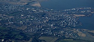
Grangemouth is a town in the Falkirk council area, Scotland. Historically part of the county of Stirlingshire, the town lies in the Forth Valley, on the banks of the Firth of Forth, 3 miles (4.8 km) east of Falkirk, 5 miles (8.0 km) west of Bo'ness and 13 miles (20.9 km) south-east of Stirling. Grangemouth had a resident population of 17,906 according to the 2001 Census. Preliminary figures from the 2011 census reported the number as 17,373.

<span class="mw-page-title-main">Stirlingshire</span> Historic county in Scotland

Stirlingshire or the County of Stirling, Scottish Gaelic: Siorrachd Sruighlea) is a historic county and registration county of Scotland. Its county town is Stirling.

<span class="mw-page-title-main">Campsie Fells</span> Range of hills in central Scotland

The Campsie Fells are a range of hills in central Scotland, stretching east to west from Denny Muir to Dumgoyne in Stirlingshire and overlooking Strathkelvin to the south. The southern extent of the range falls within East Dunbartonshire. The range overlooks the villages of Strathblane, Blanefield, Milton Of Campsie, Lennoxtown and Torrance to the south; Killearn to the west, and Fintry and Strathendrick to the north. The Fintry Hills lie further to the north; Kilpatrick Hills lie to the west and the Kilsyth Hills to the east.

<span class="mw-page-title-main">Larbert</span> Human settlement in Scotland

Larbert is a small town in the Falkirk council area of Scotland. The town lies in the Forth Valley above the River Carron which flows from the west. Larbert is three miles from the shoreline of the Firth of Forth and 2+12 miles northwest of Falkirk, the main town in the area. The village of Stenhousemuir lies directly east of Larbert, with both settlements being contiguous and sharing certain public amenities with one another.

<span class="mw-page-title-main">Larbert railway station</span> Railway station in Falkirk, Scotland, UK

Larbert railway station is a railway station serving Larbert near Falkirk, Scotland.

<span class="mw-page-title-main">Dunipace</span> Human settlement in Scotland

Dunipace is a village in the west of the Falkirk council area of Scotland. The village is 6.3 miles (10.1 km) south of Stirling and 5.3 miles (8.5 km) north-west of Falkirk. The village is situated on the north bank of the River Carron and adjoins the town of Denny, to the south of the river. Dunipace is part of the historic county of Stirlingshire.

<span class="mw-page-title-main">Carron Company</span> British producer of cast iron products

The Carron Company was an ironworks established in 1759 on the banks of the River Carron near Falkirk, in Stirlingshire, Scotland. After initial problems, the company was at the forefront of the Industrial Revolution in the United Kingdom. The company prospered through its development and production of a new short-range and short-barrelled naval cannon, the carronade. The company was one of the largest iron works in Europe through the 19th century. After 223 years, the company became insolvent in 1982 and was later acquired by the Franke Corporation, being rebranded Carron Phoenix.

<span class="mw-page-title-main">Charles Baird (engineer)</span> Scottish engineer

Charles Baird was a Scottish engineer who played an important part in the industrial and business life of 19th-century St. Petersburg. His company specialised in steam-driven machinery and was responsible for Russia's first steamboat.

<span class="mw-page-title-main">Carron, Falkirk</span> Human settlement in Scotland

Carron is a village in the Falkirk council area of Scotland. It is in the Forth Valley, about 2 miles (3.2 km) north of Falkirk, 3 miles (5 km) north-west of Grangemouth and 12 mile (0.8 km) southeast of Stenhousemuir. Carron is contiguous with village of Carronshore to the east.

<span class="mw-page-title-main">Barony of Newton</span>

The Barony of Newton is a Scottish feudal barony located in the Parish of Bothkennar near Grangemouth, Stirlingshire. The Barony was erected on 3 April 1685 with Edward Wright as baron. The Barony was subsequently confirmed by Crown Charter issued under the Great Seal of George III, William Frederick, King of Great Britain and Ireland.

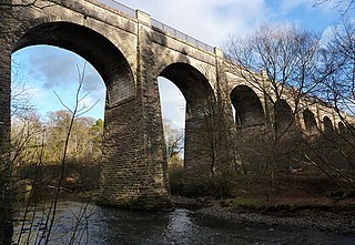
The Kilsyth and Bonnybridge Railway was a railway line in central Scotland, built to exploit the mineral extractive industries in the area; it opened in 1888. A passenger service was run, but bus competition overwhelmed it after 1920 and the passenger service closed in 1935. The goods and mineral traffic continued, but it was dependent on the industries it served, and when they declined so did the business on the railway; it closed in 1964 and none of it is now in railway use.

The Grangemouth branch railways served Grangemouth docks on the Firth of Forth, Scotland, connecting the docks to the main line railway network. The first line was opened in 1860. The docks and the branch line developed considerably, and a second branch line was opened in 1911. Grangemouth docks was exceptionally busy during World War I, supplying the Grand Fleet.

<span class="mw-page-title-main">Red Burn</span> Stream in Cumbernauld, Falkirk, Scotland, UK

The Red Burn is one of two main streams which flow out of Cumbernauld. The Scottish New Town’s name derives from the Gaelic for "the meeting of the waters" and there is broad agreement that one of these waters is the Red Burn.

References

Coordinates: 56°01′34″N3°43′00″W / 56.0261°N 3.7166°W / 56.0261; -3.7166