The River Cleddau (Welsh: Afon Cleddau) consists of the Eastern and Western Cleddau rivers in Pembrokeshire, west Wales. They unite to form the Daugleddau estuary and the important harbour of Milford Haven.
The name of the combined estuary – the Daugleddau – means “the two Cleddaus”.[1] The name Cleddau, whilst seeming to be a plural ('-au' generally denotes plurality in Welsh) comes from the Welsh word cleddyf meaning 'sword' and refers perhaps to the manner in which both rivers are incised into the landscape of Pembrokeshire.[2] A number of former Anglican parishes in the area have been combined to form the modern Church in Wales parish of Daugleddau in the Diocese of St Davids.[3]
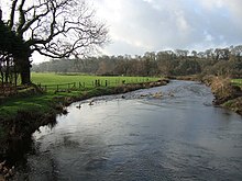
The Western Cleddau (Welsh: Cleddau Wen meaning 'white') has two branches: the eastern branch rises at Llygad Cleddau 51°58′31″N4°56′36″W / 51.9752°N 4.9434°W / 51.9752; -4.9434 in the parish of Llanfair Nant y Gôf, 4km south-east of Fishguard. It flows southwest past Scleddau, and meets the western branch at Priskilly 51°56′13″N5°01′33″W / 51.9370°N 5.0257°W / 51.9370; -5.0257. The western branch rises at Penysgwarne 51°55′53″N5°08′14″W / 51.9315°N 5.1373°W / 51.9315; -5.1373 in the parish of Llanreithan and flows east to Priskilly. The combined stream flows through Wolf's Castle, where it enters the spectacular 90 m deep Treffgarne gorge, cutting through the hard volcanic rocks of Treffgarne Mountain. It then flows south to Haverfordwest, where it becomes tidal, this being the lowest bridge crossing. The tidal estuary expands into a deep ria, and unites with the Eastern Cleddau estuary at Picton Point, to form the Daugleddau estuary. Length (Penysgwarne to Picton Point) about 40km, of which about 9km is tidal.
The Western Cleddau is an example of a misfit stream: the valley is deep, often spectacularly so, although the stream that flows in it is small. The valley was formed at the end of the last Ice Age, when the River Teifi, swollen with melt waters, was prevented from flowing into the Irish Sea by an ice dam, and flowed instead westward through the valleys of the Nyfer and Gwaun, then south along the course of the Western Cleddau.
Historically, the tidal estuary enabled sea traffic to reach Haverfordwest. It was important also for the export of anthracite, which was mined on its west bank and shipped from Hook.
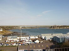
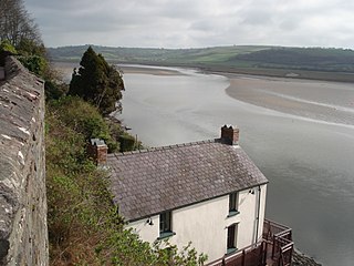
The combined estuary – the Daugleddau - from Picton Point to the Blockhouses guarding the harbour entrance, is a massive ria which is deep and wide, but sufficiently serpentine to be sheltered from high winds and rough seas, and is thus an excellent natural harbour. Because it can easily accommodate supertankers of 300,000 tonnes and more, it became from 1957 an important centre of the oil industry, with Esso, BP, Texaco, Gulf Oil and Amoco operating terminals and oil refineries. In the mid-1970s, it became briefly the UK's second biggest port in terms of tonnage. The Daugleddau and its several tributary tidal reaches are known collectively as Milford Haven. Length (from Picton Point to the Blockhouses) about 27km.
Historically, the estuary gave seaborne access to castles such as Pembroke and Carew, allowing these to be used as depots in the Norman invasion of Ireland. It was important in the early Industrial Revolution, shipping anthracite from Llangwm, Landshipping and Crescelly, and limestone from Lawrenny and West Williamston. A small fishing industry operated from harbours such as Pill, Angle and Dale,[4] but in 1790 the building of the new town of Milford commenced,[5] and a large herring fishery grew up based on its docks.[6] In its heyday, it became the UK's seventh largest fishing port, operating several hundred fishing trawlers, but with exhaustion of inshore fishing grounds, the docks were too small for large ocean-going trawlers, and fishing is now virtually totally non-existent. Milford was originally built for a naval dockyard, but this project was transferred in 1814 to Pembroke Dock on the opposite side of the estuary,[7] where it operated until closure in 1926. The town of Neyland, originally known as New Milford, was also purpose-built, this time by the Great Western Railway as a transatlantic shipping terminal. Its functions were largely transferred to Fishguard in the early 20th century.
Ecology
Both branches of the Cleddau are noteworthy for their diverse aquatic ecology that has been largely untouched by man's activities. The rivers support otter populations and a wide variety of fish species including Lampreys. Stretches of both rivers have been designated as SSSIs[8][9][10][11] because they are of special interest primarily for important populations of otter Lutra lutra, bullhead Cottus gobio, river lamprey Lampetra fluviatilis and brook lamprey Lampetra planeri. They are also of special interest for sea lamprey Petromyzon marinus; for the range of river habitats including beds of submerged aquatic plants often dominated by water-crowfoot Ranunculus spp., as well as a variety of associated riverside habitats.[12]
The Cleddau rivers are also a Special Area of Conservation designated for the European bullhead (Cottus gobio), European river lamprey (Lampetra fluviatilis), Brook lamprey (Lampetra planeri), Otter (Lutra lutra), Sea lamprey (Petromyzon marinus); rivers with floating vegetation often dominated by water-crowfoot (watercourses of plain to montane levels with the Ranunculion fluitantis and Callitricho-Batrachionvegetation); active raised bogs; and Alder woodlands on floodplains (Alluvial forests with Alnus glutinosa and Fraxinus excelsior (Alno-Padion, Alnion incanae, Salicion albae)).[13]
Additionally, land around a north-eastern tributary of the Eastern Cleddau, Gweunydd Blaencleddau,[14] is designated as a Special Area of Conservation for habitats including: calcium-rich springwater-fed fens - Alkaline fens; the southern damselfly (Coenagrion mercuriale), marsh fritillary butterflyEuphydryas (Eurodryas, Hypodryas) aurinia; purple moor-grass meadows - molinia meadows on calcareous, peaty or clayey-silt-laden soils (Molinion caeruleae); wet heathland with cross-leaved heath Rhostiroedd gwlyb – Northern Atlantic wet heaths with Erica tetralix; very wet mires often identified by an unstable 'quaking' surface – transition mires and quaking bogs; and blanket bogs.[15]
See also
Dungleddy, an ancient hundred whose name continues in the present day as Daugleddau
Notes
↑ Charles, B. G, The Placenames of Pembrokeshire, National Library of Wales, Aberystwyth, 1992, Vol 1, pp. 6–7
↑ Owen, H. W. & Morgan, R. 2007 Dictionary of the Place-names of Wales Gomer Press, Ceredigion
Dyfed is a preserved county in southwestern Wales. It is a mostly rural area with a coastline on the Irish Sea and the Bristol Channel.
Pembrokeshire is a county in the south-west of Wales. It is bordered by Carmarthenshire to the east, Ceredigion to the northeast, and otherwise by the sea. Haverfordwest is the largest town and administrative headquarters of Pembrokeshire County Council.
Carmarthen Bay is an inlet of the South Wales coast, including notable beaches such as Pendine Sands and Cefn Sidan sands. Carmarthen Bay is partially within the Pembrokeshire Coast National Park. The Joint Nature Conservation Committee list Carmarthen Bay and Estuaries as a Special Area of Conservation.
St Brides Bay is a bay in western Pembrokeshire, West Wales.
The River Teifi in Wales forms the boundary for most of its length between the counties of Ceredigion and Carmarthenshire, and for the final 3 miles (4.8 km) of its total length of 76 miles (122 km), the boundary between Ceredigion and Pembrokeshire. Its estuary is northwest of Cardigan, known in Welsh as Aberteifi, meaning 'mouth of the Teifi'. Teifi has formerly been anglicised as "Tivy".
The River Taf is a river in West Wales. It rises in the Preseli Hills, Pembrokeshire, and continues through Carmarthenshire to Laugharne. It is one of the three rivers to enter the sea on the east side of Carmarthen Bay. The other two are the River Gwendraeth and River Tywi.
Picton Castle is a medieval castle near Haverfordwest in the community of Uzmaston, Boulston and Slebech, Pembrokeshire, Wales. Originally built at the end of the 13th century by a Flemish knight, it later came into the hands of Sir John Wogan. The castle and gardens are now owned and managed by the Picton Castle Trust, a registered charity, for the benefit of the public. It is of unusual construction and has been remodelled several times during its history. The castle is a Grade I listed building and its gardens and park are designated at Grade II* on the Cadw/ICOMOS Register of Parks and Gardens of Special Historic Interest in Wales.
Milford Haven Waterway is a natural harbour in Pembrokeshire, Wales. It is a ria or drowned valley which was flooded at the end of the last ice age. The Daugleddau estuary winds west to the sea. As one of the deepest natural harbours in the world, it is a busy shipping channel, trafficked by ferries from Pembroke Dock to Ireland, oil tankers and pleasure craft. Admiral Horatio Nelson, visiting the haven with the Hamiltons, described it as the next best natural harbour to Trincomalee in Ceylon and "the finest port in Christendom". Much of the coastline of the Waterway is designated as a Site of Special Scientific Interest, listed as Milford Haven Waterway SSSI.
The A477 is a major road in South Pembrokeshire and Carmarthenshire connecting St Clears and Johnston. Its route includes the Cleddau Bridge, a former toll bridge linking Pembroke Dock and Neyland.
The Hundred of Roose was a hundred in Pembrokeshire, Wales. It has its origins in the pre-Norman cantref of Rhos and was formalised as a hundred by the Laws in Wales Acts 1535–1542. Its area was about 102 square miles (260 km2). The area became an English "plantation" in the 12th century, part of the English-speaking Little England beyond Wales.
The Cantref of Penfro was one of the seven cantrefi of the Kingdom of Dyfed. It subsequently became part of Deheubarth in around 950. It consisted of the long peninsular part of Dyfed south of the Eastern Cleddau and the Daugleddau estuary, and bordered on its landward side by Cantref Gwarthaf. The name, meaning "land's end", derives from Pen and "fro". Its area was approximately 140 square miles (360 km2).
Cleddau may refer to:
Corsydd Llangloffan is a Site of Special Scientific Interest in Pembrokeshire, South Wales. It has been designated as a Site of Special Scientific Interest since February 1992 in an attempt to protect its fragile biological elements. The site has an area of 56.7 hectares and is managed by Natural Resources Wales.
Gweunydd Blaencleddau is a large wetland complex in a shallow south-west valley around the headwaters of the Eastern Cleddau river. It is a Site of Special Scientific Interest (SSSI) and a Special Area of Conservation (SAC) situated in Pembrokeshire, South Wales.
River Syfynwy is a river entirely within Pembrokeshire, Wales, rising in the Preseli Hills, feeding the Rosebush and Llys y Fran reservoirs and joining the Eastern Cleddau to the south. It is a river considered to be important as an ecological indicator and part is in a site of special scientific interest.
Aber Taf is a large Site of Special Scientific Interest (SSSI) in Carmarthenshire, Wales, and forms part of the Carmarthen Bay and Estuaries Special Area of Conservation.
Cemaes Head is a headland and nature reserve in north Pembrokeshire. It lies in the community of St Dogmaels, within the Pembrokeshire Coast National Park. To the west and north it overlooks Cardigan Bay, and to the east Cardigan Island and the estuary of the River Teifi.
Milford Haven Waterway, is a Site of Special Scientific Interest (SSSI) on Milford Haven Waterway in Pembrokeshire, South Wales, designated since 2002. The site is protected for a wide range of reasons, including its geology, marine environment and ecosystems, and to protect a diversity of flora and fauna.
This page is based on this Wikipedia article Text is available under the CC BY-SA 4.0 license; additional terms may apply. Images, videos and audio are available under their respective licenses.