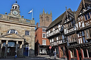
Ludlow is a market town in Shropshire, England. The town is significant in the history of the Welsh Marches and in relation to Wales. It is located 28 miles (45 km) south of Shrewsbury and 23 miles (37 km) north of Hereford, on the A49 road which bypasses the town. Ludlow currently has a population of approximately 11,000.

The River Teme rises in Mid Wales, south of Newtown, and flows southeast roughly forming the border between England and Wales for several miles through Knighton before becoming fully English in the vicinity of Bucknell and continuing east to Ludlow in Shropshire, then to the north of Tenbury Wells on the Shropshire/Worcestershire border there, on its way to join the River Severn south of Worcester. The whole of the River Teme was designated as an SSSI, by English Nature, in 1996.

Craven Arms is a market town and civil parish in Shropshire, England, on the A49 road and the Welsh Marches railway line, which link it north and south to the larger towns of Shrewsbury and Ludlow respectively. The Heart of Wales railway line joins the Welsh Marches line at Craven Arms and the town is served by Craven Arms railway station. The town is enclosed to the north by the Shropshire Hills Area of Outstanding Natural Beauty, and to the south is the fortified manor house of Stokesay Castle.

The Shropshire Hills area, in the English county of Shropshire, is designated as an Area of Outstanding Natural Beauty (AONB). It is located in the south of the county, extending to its border with Wales. Designated in 1958, the area encompasses 802 square kilometres (310 sq mi) of land primarily in south-west Shropshire, taking its name from the upland region of the Shropshire Hills. The A49 road and Welsh Marches Railway Line bisect the area north-south, passing through or near Shrewsbury, Church Stretton, Craven Arms and Ludlow.

The Shropshire Hills is an upland area and one of the natural regions of England. They lie wholly within the county of Shropshire and encompass several distinctive and well-known landmarks, such as the Long Mynd, Wenlock Edge, The Wrekin and the Clees.
Ashford Bowdler is a small village and civil parish in south Shropshire, England, near the county border with Herefordshire.

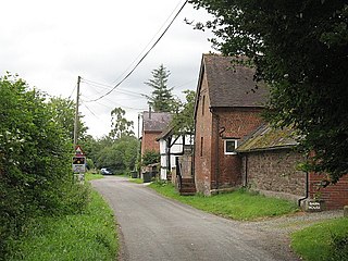
Bromfield is a village and civil parish in Shropshire, England.
Ludford is a small village and civil parish in south Shropshire, England. The parish is situated adjacent to the market town of Ludlow and was, until 1895, partly in Herefordshire.

Stanton Lacy is a small village and geographically large civil parish located in south Shropshire, England, 3 miles (4.8 km) north of Ludlow.

Bouldon is a hamlet in Shropshire, England. It lies in the civil parish of Diddlebury.

Diddlebury is a small village and large civil parish in Shropshire, England. It is situated in the Corvedale on the B4368 road about 5 miles (8 km) north east of Craven Arms. The population of the Civil Ward in 2011 was 670.

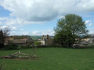
Corfton is a small village in Shropshire, England, located 4.5 miles (7.2 km) east of Craven Arms and 7.5 miles (12.1 km) north of Ludlow, the two nearest towns.

Burway Bridge is a bridge in Ludlow, Shropshire, England. It takes the B4361 road across the River Corve.

Munslow is a small village and civil parish in Shropshire, England. It is situated on the B4368, 7 miles (11 km) northeast of the small town of Craven Arms, in the Corvedale, at around 140 metres (460 ft) above sea level.
Peaton is a hamlet in the civil parish of Diddlebury in Shropshire, England.

Stanton Long is a small village and civil parish situated in the district of Corve Dale, Shropshire, England. It is one of three parishes in the local area, including Easthope and Shipton. In the National Gazetteer of Great Britain and Ireland 1868, it was described as:

Munslow is a hundred of Shropshire, England. It was formed with the amalgamation of the Anglo-Saxon hundreds of Patton and Culvestan during the reign of Henry I. Hundreds in England had various judicial, fiscal and other local government functions, their importance gradually declining from the end of manorialism to the latter part of the 19th century.
Culvestan was a hundred of Shropshire, England. Formed during Anglo-Saxon England, it encompassed manors in central southern Shropshire, and was amalgamated during the reign of Henry I with the neighbouring hundred of Patton to form the Munslow hundred.
Patton was a hundred of Shropshire, England. Formed during Anglo-Saxon England, it encompassed manors in eastern central Shropshire, and was amalgamated during the reign of Henry I with the neighbouring hundred of Culvestan to form the Munslow hundred.

The Corvedale Three Castles Walk is a waymarked recreational circular walk of about 11.5 miles (18.5 km) located in the Corvedale, Shropshire, England. The walk is classed as Easy and Heritage by the Long Distance Walkers Association. The walk nominally starts at the public car park opposite the Swan Inn in Aston Munslow, but other starting points are possible although parking is limited. The walk goes past Broncroft Castle (52.476422°N 2.672107°W), Corfham Castle (earthworks) (52.460758°N 2.700383°W), and Corfton Castle (earthworks) (52.458237°N 2.740205°W). A leaflet is available detailing the walk and can be obtained from some local pubs and retailers. Some bed and breakfasts also have it available. In addition there is a book Castle and Corvedale available from the same sources.
