The River Lark crosses the border between Suffolk and Cambridgeshire in England. It is a tributary of the River Great Ouse, and was extended when that river was re-routed as part of drainage improvements. It is thought to have been used for navigation since Roman times, and improvements to its navigability were made in 1638 and in the early 18th century, when locks and staunches were built. Special powers to improve the river from Mildenhall to Bury St Edmunds were granted by statute. The upper terminus was on the northern edge of Bury St Edmunds, but a new dock was opened near the railway station after the Eastern Union Railway opened its line in 1846.

The River Avon is a river in the southwest of England. To distinguish it from a number of other rivers of the same name, it is often called the Bristol Avon. The name 'Avon' is loaned from an ancestor of the Welsh word afon, meaning 'river'.

The River Goyt is a tributary of the River Mersey in North West England.

The River Churn is a tributary of the River Thames in central England. It rises at Seven Springs in Gloucestershire and flows south for approximately 37.3 km (23.2 mi) to meet the Thames at Cricklade in Wiltshire. Its length from its source to the confluence with the Thames is greater than that of the Thames from Thames Head, but the Churn is regarded as a tributary, rather than the main river.

John Selwyn Gummer, Baron Deben, is a British Conservative Party politician, formerly the Member of Parliament (MP) for Suffolk Coastal and now a member of the House of Lords. He was Chairman of the Conservative Party from 1983 to 1985 and held various government posts including Secretary of State for the Environment from 1993 to 1997.

The River Lugg rises near Llangynllo in Radnorshire, Wales. It flows through the border town of Presteigne and then through Herefordshire, England, where it meets its main tributary, the River Arrow, to the south of Leominster. It flows into the River Wye downstream of Hereford at Mordiford, around 63 miles (101 km) from its source. Its name comes from a Welsh root, and means "bright stream".

The River Lune is a river 53 miles (85 km) in length in Cumbria and Lancashire, England.

Cock Beck is a stream in the outlying areas of East Leeds, West Yorkshire, England, which runs from its source due to a runoff north-west of Whinmoor, skirting east of Swarcliffe and Manston, past Pendas Fields, Scholes, Barwick-in-Elmet, Aberford, Towton, Stutton, and Tadcaster, where it flows into the River Wharfe.

The River Vyrnwy flows through northern Powys, Wales, and Shropshire, England. The name derives from Severn, the river of which it is a tributary.

The River Anker flows through Nuneaton, England. It is a major tributary of the River Tame, which it joins in Tamworth. The name derives from the old British for winding river. From source to river mouth at Tamworth is 50 kilometres (31 mi).

The River Yarrow is in Lancashire, with its source at an area called Will Narr at Hordern Stoops, along Spitlers Edge - the Chorley/Blackburn boundary - on the West Pennine Moors. The river feeds the Yarrow Reservoir, which in turn feeds the Anglezarke and Upper and Lower Rivington Reservoirs. Upon leaving the reservoirs via a pumping station, the river passes through an area that was formerly known as Abyssinia. Currently, this area is within the boundaries of Heath Charnock and Limbrick, but the original name was given because it was a route frequented by coal miners, and the workers were said to look like natives of Abyssinia : until the mid 20th century it was usual for miners to return from work covered in coal dust.

The River Dun is a tributary of the River Kennet, flowing through Wiltshire and Berkshire in England. Its main source is in the parish of Great Bedwyn, Wiltshire and it flows 16 kilometres (10 mi) in a northeasterly direction into Berkshire. It discharges into the Kennet at Hungerford, which has a smaller average flow and width upstream of that point.

West Beck is the common name given to the upper section of the old River Hull, as it rises in the foothills of the Yorkshire Wolds. After reaching Frodingham Beck at Emmotland, it becomes called the River Hull. It is noteworthy for being the most northerly chalk stream in England. It provides fly fishing for wild brown trout and grayling.
River Skirfare is a small river in North Yorkshire, England, that flows through Littondale and ends where it joins the larger River Wharfe. The source is the confluence of Foxup Beck and Cosh Beck at the hamlet of Foxup.

The River Nadder is a tributary of the River Avon, flowing in south Wiltshire, England.
The River Wenning is a tributary of the River Lune, flowing through North Yorkshire and Lancashire. The name derives from the Old English Wann, meaning dark river.

The River Wey is a main tributary of the River Thames in south east England. Its two branches, one of which rises near Alton in Hampshire and the other in West Sussex to the south of Haslemere, join at Tilford in Surrey. Once combined, the flow is eastwards then northwards via Godalming and Guildford to meet the Thames at Weybridge. Downstream the river forms the backdrop to Newark Priory and Brooklands. The Wey and Godalming Navigations were built in the 17th and 18th centuries, to create a navigable route from Godalming to the Thames.

Newbourne Springs is a 15.7-hectare (39-acre) biological Site of Special Scientific Interest in Newbourne in Suffolk. It is owned by Anglian Water and managed by the Suffolk Wildlife Trust.

The Ea Beck, also spelled Eaubeck or Eau Beck, is a small river in South Yorkshire, England, that flows eastwards into the River Don at Thorpe-in-Balne. The Environment Agency lists the beck as starting at South Elmsall, but mapping lists the beck with several names along its course. The beck has twice flooded areas and villages that it passes through in the 21st century.

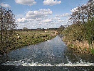
Bucklesham Mill River – sometimes referred to simply as Mill River – is a tributary of the River Deben in Suffolk, England. It is 11.3 km long and with the Newbourne Stream which flows into it at Newbourne it constitutes the Bucklesham Mill River Water Body with a catchment area of 46.298 km2.

