Rivercess County

Last updated

Rivercess County
Flag of Rivercess County.svg
River Cess in Liberia.svg
Location in Liberia
Coordinates: 6°0′N9°20′W / 6.000°N 9.333°W / 6.000; -9.333
CountryFlag of Liberia.svg  Liberia
Capital Cesstos City
Districts 8
Established13 December 1985
Government
  SuperintendentJ.BisMark Karbiah
Area
  Total5,594 km2 (2,160 sq mi)
Population
 (2008)
  Total71,509
  Density12.8/km2 (33/sq mi)
Time zone UTC+0 (GMT)
HDI (2018)0.430 [1]
low · 10th of 15

Rivercess County [2] is a county in the south-central portion of the West African nation of Liberia. One of 15 counties that compose the first-level of administrative division in the nation, it has six districts. Cesstos City serves as the capital with the area of the county measuring 2,160 square miles (5,600 km2). As of the 2008 Census, it had a population of 71,509, making it the second least populous county in Liberia after Grand Kru County. [3]

Contents

Eighth largest in area, the county was created in 1984. It is bordered by Grand Bassa County to the west, Nimba County on the northeast, and Sinoe County to the southeast, while the southern part lies on the Atlantic Ocean. The current County Superintendent is B. Rancy Ziankahn. [4]

Geography

River Cess County accommodates the FDA/OTC Reforestation Project with a designated National Plantation area of 276 ha (680 acres). [5] The county has coastal plains that raises to a height of 30 m (98 ft) above the sea-level inward to a distance of 25 km (16 mi). These plains receive a very high rainfall ranging from 4,450 mm (175 in) to 4,500 mm (180 in) per year and receive longer sunshine with a humidity of 85 to 95 percent. It is swampy along rivers and creeks, while there are patches of Savannah woodland. Rice and cassava interplanted with Sugarcane are the major crops grown in the region. The northern or the upper part of the highland has tropical forest which is usually 30 m (98 ft) above the mean sea level. The regions receive a bimodal rainfall with a gap of two weeks in between. Cocoa, coffee, Lofa, bong, Nimba, rubber, citrus oil, and palm are the most common crops in the region. [6]

Demographics

As of 2008, the county had a population of 71,509: 37,224 male and 34,285 female. The sex ratio was 108.6 compared to 99 in the 1994 census. [7] The number of households during 2008 was 15,829 and the average size of the households was 5. [8] The population was 1.80 percent of the total population, while it was 2.10 percent in 1994. The county had an area of 2,183 sq mi and the density per square mile was 33. The density during the 1984 census stood at 17. [3] Liberia experienced civil war during various times and the total number of people displaced on account of wars as of 2008 in the county was 24,318. [9] The number of people residing in urban areas was 2,389, with 1,262 males and 1,127 females. The total number of people in rural areas was 69,120, with 35,962 males and 33,158 females. The total fraction of people residing in urban areas was 3.34 percent, while the remaining 97 percent were living in rural areas. The number of people resettled as of 2008 was 12,817 while the number of people who were not resettled was 2,253. [10] The number of literates above the age of ten as of 2008 was 34,838 while the number of illiterates was 35,323 making the literacy rate 49.65 percent. The total number of literate males was 22,702 while the total number of literate females was 12,136. [8] 75% of the population is Christian. Most of the rest are practitioners of animist faiths. [4]

Economy

As of 2011, the area of rice plantation was 4,960 ha (12,300 acres), which was 2.077 percent of the total area of rice planted in the country. The total production stood at 9060 metric tonnes. As of 2011, the number of Cassava plantations was 4460, which was 3.6 percent of the total area of Cassava planted in the country. The total production stood at 400 metric tonnes. The number of Cocoa plantations was 400, which was 1 percent of the total area of Cassava planted in the country. The number of rubber plantations was 1420, which was 2.3 percent of the total area of Cassava planted in the country. The number of Coffee plantations was 170, which was 0.8 percent of the total area of Cassava planted in the country. [11]

As of 2008, the county had 1,570 paid employees, 18,807 self-employed people, 9,786 family workers, 844 people looking for work, 1,950 not working people, 5,379 people working in households, 10,784 students, 142 retired people, 703 incapacitated people, 411 part-time workers and 7,321 others, making the total working population of 57,697. [12]

Districts

The districts of the county include (2008 population): Bearwor District (3,854), Central RiverCess District (8,303), Doedain District (13,041), Fen River District (12,630), Jo River District (8,921), Norwein District (13,900), Sam Gbalor District (3,714) and Zartlahn District (7,146). The original districts in the province were Morweh District and Timbo District. [4] [3] The Legislature of Liberia was modeled based on the Legislature of the United States. It is bicameral in nature with a Senate and the House of Representatives. There are 15 counties in the country and based on the population, each county is defined to have at least two members, while the total number of members to the house, including the Speaker, is 64. Each member represents an electoral district and is elected to a six-year term based on popular vote. [13] There were 30 senators, two each for the 13 counties and they serve a nine-year term. Senators are also elected based on a plurality of votes. The Vice-President is the head of the Senate and he also acts as President in his absence. [13]

Notes

  1. "Sub-national HDI". Global Data Lab. Retrieved 27 May 2024.
  2. "20 L.C.L. Rev. Decree No. 15, § 2". Liberia Legal Information Institute. Retrieved 27 May 2024.
  3. 1 2 3 2008 Population and Housing census, p. 10
  4. 1 2 3 "Rivercess County Development Agenda" (PDF). Republic of Liberia. 2008. Archived from the original (PDF) on 22 November 2010. Retrieved 20 October 2008.
  5. National Forests Classification, Acreages, Location And Utilization Index Division Of Scientific Research (PDF) (Report). Forest Research and Development (R&D). Archived from the original (PDF) on 14 March 2016. Retrieved 8 November 2016.
  6. "Liberia - Country pastures and forage resource profile". Food and Agricultural Organization. Archived from the original on 2 November 2016. Retrieved 9 September 2016.
  7. 2008 Population and Housing census, p. A12 - 16
  8. 1 2 2008 Population and Housing census, pp. A47-51
  9. 2008 Population and Housing census, pp. A21-31
  10. 2008 Population and Housing census, pp. A26-31
  11. "Plantation statistics of Liberia". Liberia Institute of Statistics & Geo-Information Services. Retrieved 9 November 2016.
  12. 2008 Population and Housing census, p. 154
  13. 1 2 "About The Republic Of Liberia – Politics". Ministry of Information, Government of Liberia. 2014. Archived from the original on 23 October 2016. Retrieved 23 October 2016.

Related Research Articles

<span class="mw-page-title-main">Liberia</span> Country in West Africa

Liberia, officially the Republic of Liberia, is a country on the West African coast. It is bordered by Sierra Leone to its northwest, Guinea to its north, Ivory Coast to its east, and the Atlantic Ocean to its south and southwest. It has a population of around five and one-half million and covers an area of 43,000 square miles (111,369 km2). The country's official language is English; however, over 20 indigenous languages are spoken, reflecting the country's ethnic and cultural diversity. The capital and largest city is Monrovia.

<span class="mw-page-title-main">Georgetown, South Carolina</span> City in South Carolina, United States

Georgetown is the third oldest city in the U.S. state of South Carolina and the county seat of Georgetown County, in the Lowcountry. As of the 2010 census it had a population of 9,163. Located on Winyah Bay at the confluence of the Black, Great Pee Dee, Waccamaw, and Sampit rivers, Georgetown is the second largest seaport in South Carolina, handling over 960,000 tons of materials a year, while Charleston is the largest.

<span class="mw-page-title-main">Montserrado County</span> County in Liberia

Montserrado County is a county in the northwestern portion of the West African nation of Liberia containing its national capital, Monrovia. One of 15 counties that comprise the first-level of administrative division in the nation, it has 17 sub political districts. As of the 2022 Census, it had a population of 1,920,914, making it the most populous county in Liberia. The area of the county measures 738.5 square miles (1,913 km2), the smallest in the country. Bensonville serves as the capital.

<span class="mw-page-title-main">Lofa County</span> County of Liberia

Lofa is a county in the northernmost portion of Liberia. One of 15 counties that constitute the first-level of administrative division in the nation, it has nine districts. Voinjama serves as the capital with the area of the county measuring 3,854 square miles (9,980 km2). As of the 2022 Census, it had a population of 367,376, making it Liberia's fourth most populous county.

<span class="mw-page-title-main">Grand Cape Mount County</span> County of Liberia

Grand Cape Mount is a county in the northwestern portion of the West African nation of Liberia. One of 15 counties that constitute the first-level of administrative division in the nation, it has five districts. Robertsport serves as the capital with the area of the county measuring 1,993 square miles (5,160 km2). As of the 2008 Census, it had a population of 129,817, making it the eighth most populous county in Liberia. The county is bordered by Gbarpolu County to the northeast and Bomi County to the southeast. The northern part of Grand Cape Mount borders the nation of Sierra Leone, while to the west lies the Atlantic Ocean.

<span class="mw-page-title-main">Maryland County</span> County of Liberia

Maryland County is a county in the southeastern portion of Liberia. One of 15 counties that comprise the first-level of administrative division in the nation, it has two districts. Harper serves as the capital with the area of the county measuring 887 square miles (2,300 km2). As of the 2022 Census, it had a population of 172,202, making it the ninth most populous county in Liberia.

Sanniquellie is a city and the capital of Nimba County and Sanniquellie-Mahn District, Liberia. It is located in the north-east of the country at coordinates 07°21'49" N 008°42'40" W. The average altitude of the city is 420 metres above the sea level. As of the 2008 national census, the population stood at 11,415. The most represented tribes are Mano, Gio and Mandingo.

<span class="mw-page-title-main">Nimba County</span> County of Liberia

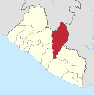
Nimba County is a county in northeastern Liberia that shares borders with the Republic of Côte d'Ivoire in the East and the Republic of Guinea in the Northwest. Its capital city is Sanniquellie and its most populous city is Ganta. With the county's area measuring 11,551 square miles (29,920 km2), Nimba is the largest of Liberia's 15 counties. The county has six statutory districts. As of the 2022 Census, it had a population of 621,841, making it the second most populous county in Liberia.

<span class="mw-page-title-main">Bomi County</span> County of Liberia

Bomi is a county in the northwestern portion of the West African nation of Liberia. The county was established in 1984. The county's area is 746 square miles (1,900 km2).

<span class="mw-page-title-main">Grand Bassa County</span> County of Liberia

Grand Bassa is a county in the west-central portion of the West African nation of Liberia. One of 15 counties that comprise the first-level of administrative division in the nation, it has eight districts. Buchanan serves as the capital with the area of the county measuring 3,064 square miles (7,940 km2). As of the 2022 Census, it had a population of 293,557, making it the sixth most populous county in Liberia.

<span class="mw-page-title-main">Grand Gedeh County</span> County of Liberia

Grand Gedeh is a county in the eastern portion of the West African nation of Liberia. One of 15 counties that constitute the first-level of administrative division in the nation, it has three districts. Zwedru serves as the capital of the county. Measuring 4,048 square miles (10,480 km2), it is larger than 28 independent countries including Lebanon, Trinidad and Tobago, Cape Verde, Malta and Mauritius and the combined area of the US states of Delaware and Rhode Island. As of the 2022 Census, it had a population of 216,692, making it the 7th most populous county in Liberia. Grand Gedeh has lower tropical forests which has mid size hills composed of various valleys and water courses. These forests receive a very high rainfall ranging from 3,000 mm (120 in) to 4,100 mm (160 in) per year.

<span class="mw-page-title-main">Margibi County</span> County of Liberia

Margibi is a county on the north to central coast of Liberia. One of 15 counties that constitute the first-level of administrative division in the nation, it has five districts. Kakata serves as the capital with the area of the county measuring 1,010 square miles (2,600 km2). As of the 2022 Census, it had a population of 304,946, making it the fifth most populous county in Liberia.

<span class="mw-page-title-main">Sinoe County</span> County in Liberia

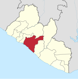
Sinoe is one of Liberia's 15 counties and it has 17 districts. Greenville is the county's capital. As of the 2022 Census, it had a population of 150,358, making it one of the least populous counties in Liberia. Sinoe has the third-largest area of all Liberia's counties; it has the second least-dense population after Gbarpolu County. The County was originally a colony in the name Mississippi-in-Africa, under auspices of a chapter of the American Colonization Society as it was created with slaves from Mississippi to Liberia.

<span class="mw-page-title-main">River Gee County</span> County of Liberia

River Gee is a county in the southern portion of Liberia. One of 15 counties that constitute the first-level of administrative division in the nation, it has six districts. Fish Town serves as the capital with the area of the county measuring 1,974 square miles (5,110 km2). As of the 2022 Census, it had a population of 124,653, making it one of the least populous counties in Liberia. It was created in 2000.

<span class="mw-page-title-main">Barclayville</span> Place in Grand Kru County, Liberia

Barclayville is the capital and most populous settlement in Grand Kru County, located in southeastern Liberia about 10 miles inland from Picinicess. As of the 2008 national census, the population stood at 2,733. The Barclayville township straddles the banks of the Na River. Roads from Kanweaken to the northwest, Pleebo to the southeast, and to Picinicess and Grand Cess to the southeast, all intersect at Barclayville.

Morweh District is a district of Rivercess County, Liberia. It was one of the county's two original districts.

Timbo District was one of the two original districts of Rivercess County, Liberia.

<span class="mw-page-title-main">Administrative divisions of Liberia</span>

Liberia is divided into fifteen first-level administrative divisions called counties, which, in turn, are subdivided into a total of 90 second-level administrative divisions called districts and further subdivided into third-level administrative divisions called clans.

Central RiverCess District is one of 8 districts of Rivercess County, Liberia. As of 2008, the population was 8,303.

<span class="mw-page-title-main">Agriculture in Liberia</span>

Agriculture in Liberia is a major sector of the country's economy worth 38.8% of GDP, employing more than 70% of the population and providing a valuable export for one of the world's least developed countries. Liberia has a climate favourable to farming, vast forests, and an abundance of water, yet low yields mean that over half of foodstuffs are imported, with net agricultural trade at -$73.12 million in 2010. This was dismissed as a "misconception" by Liberia's Minister of Agriculture.

References