Roads in Hungary

Last updated
Border road sign with general speed-limits in Hungary. Hungary road sign G-401.svg
Border road sign with general speed-limits in Hungary.

Public roads in Hungary are ranked according to importance and traffic as follows:

Contents

Some of the national roads are part of the European route scheme.
European routes passing through Hungary: E60; E65; E66; E68; E71; E73; E75; E77; E79 (Class A); E573; E653; E661 (Class B).

Highways

Highways in Hungary in December 2023.
.mw-parser-output .legend{page-break-inside:avoid;break-inside:avoid-column}.mw-parser-output .legend-color{display:inline-block;min-width:1.25em;height:1.25em;line-height:1.25;margin:1px 0;text-align:center;border:1px solid black;background-color:transparent;color:black}.mw-parser-output .legend-text{}
in service
under construction or proposed Magyarorszag autopalyai, autoutjai, gyorsforgalmi utjai es kiemelt foutjai.png
Highways in Hungary in December 2023.
  in service
  under construction or proposed
M7 motorway near Balatonfokajar junction. M7 Balatonfokajar2.jpg
M7 motorway near Balatonfőkajár junction.

They have one lane in each direction, signs are white-on-blue and the normal speed limit is 130 km/h, in expressways 110 km/h. According to the Állami Autópályakezelő Zrt. ("State Motorway Management Plc."), the total length of the Hungarian motorway system was 1,400.6 kilometers in 2013. [1] The construction of the Hungarian motorway system started in 1964 with M7, which finished in 1975 between Budapest and Lake Balaton. The total length of the system reached 200 km in 1980, 500 km in 1998, and 1000 km in 2007.

Road signs are white shield on blue and the abbreviation for both types of highways is M.

The main differences are that motorways feature emergency lanes and the maximum allowed speed limit is 130 km/h (81 mph), while expressways may be built without them and the speed limit is 110 km/h (68 mph).

  1. Expressways may be built without paved emergency lanes.
  2. Expressways are designated for lower speed than motorways. For example, the road curvature can be higher and the lanes are usually narrower (3.5 m vs 3.75 m).
  3. Expressways can have a single carriageway on sections with low traffic density.

Development of the overall length (at the end of):

Total length of highways in use in Hungary
Year196519701975198019851990199520002005201020152020dec 2023
Length [km]7851322133023473845317771,2411,3991,7451,880

List of highways

Hungary road sign E-016.svg
Motorways:

M1 (Hu) Otszogletu kek tabla.svg M1 | M3 (Hu) Otszogletu kek tabla.svg M3 | M4 (Hu) Otszogletu kek tabla.svg M4 | M5 (Hu) Otszogletu kek tabla.svg M5 | M6 (Hu) Otszogletu kek tabla.svg M6 | M7 (Hu) Otszogletu kek tabla.svg M7 | M8 (Hu) Otszogletu kek tabla.svg M8 | M15 (Hu) Otszogletu kek tabla.svg M15 | M30 (Hu) Otszogletu kek tabla.svg M30 | M31 (Hu) Otszogletu kek tabla.svg M31 | M35 (Hu) Otszogletu kek tabla.svg M35 | M43 (Hu) Otszogletu kek tabla.svg M43 | M60 (Hu) Otszogletu kek tabla.svg M60 | M70 (Hu) Otszogletu kek tabla.svg M70

Hungary road sign E-018.svg
Expressways:

M0 (Hu) Otszogletu kek tabla.svg M0 | M2 (Hu) Otszogletu kek tabla.svg M2 | M4 (Hu) Otszogletu kek tabla.svg M4 | M9 (Hu) Otszogletu kek tabla.svg M9 | M19 (Hu) Otszogletu kek tabla.svg M19 | M25 (Hu) Otszogletu kek tabla.svg M25 | M44 (Hu) Otszogletu kek tabla.svg M44 | M49 (Hu) Otszogletu kek tabla.svg M49 | M51 (Hu) Otszogletu kek tabla.svg M51 | M76 (Hu) Otszogletu kek tabla.svg M76 | M85 (Hu) Otszogletu kek tabla.svg M85 | M86 (Hu) Otszogletu kek tabla.svg M86

M10 | M32 | M34 | M71 | M87 | M100 | M200

Main roads

Main roads in Hungary. Magyarorszag foutjai.png
Main roads in Hungary.
it symbolizes the starting point of the kilometer numbering of the main roads starting from the capital city. 0 km fortepan 99382.jpg
it symbolizes the starting point of the kilometer numbering of the main roads starting from the capital city.
Main road 3 near Encs. Route 3 Hungary Encs.jpg
Main road 3 near Encs.
Main road 21 near Zagyvaszanto. Route 21 Zagyvaszanto.jpg
Main road 21 near Zagyvaszántó.
Main road 22 near Orhalom. Orhalom002.JPG
Main road 22 near Őrhalom.
Main road 31 near Maglod. Mendeistrasse, Zeichen Vorfahrtstrasse, Nummerntafel, Uberholverbot fur Kraftfahrzeuge aller Art, 2023 Maglod.jpg
Main road 31 near Maglód.
Main road 34 in Kunhegyes. Templom (rakoczi ut) - panoramio (2).jpg
Main road 34 in Kunhegyes.
Main road 38 in Rakamaz. Rakamaz, Hungary - panoramio (9).jpg
Main road 38 in Rakamaz.
Signs of the main road 45 in Szentes. Szentes Attila ut kerekparut 2012-12-31.JPG
Signs of the main road 45 in Szentes.
Signs of the main road 51 near Apsotag. Route 51 in Hungary (near Apostag).JPG
Signs of the main road 51 near Apsotag.

They have one lane in each direction, signs are white-on-green and the normal speed limit is 90 km/h.

Primary main roads

Roads categorized as state roads, primary main roads are 2,169 km in total length as of December 2022. [2] The routes are marked with one, two, or three-digit numbers.

DesignationRouteLength
1 (Hu) Otszogletu zold tabla.svg 1 Budapest - Budaörs - Bicske - Tatabánya - Tata - Komárom - Győr - Mosonmagyaróvár - Hegyeshalom / Border with Austria B10-AT.svg 177 km
2 (Hu) Otszogletu zold tabla.svg 2 Budapest - Dunakeszi - Vác - Rétság - Parassapuszta (Hont) / Border with Slovakia Cesta I. triedy cislo 66.svg 78 km
3 (Hu) Otszogletu zold tabla.svg 3 Budapest - Gödöllő - Aszód - Hatvan - Gyöngyös - Füzesabony - Mezőkövesd - Emőd - Nyékládháza - Miskolc - Szikszó - Encs - Tornyosnémeti / Border with Slovakia Cesta I. triedy cislo 17.svg 247 km
4 (Hu) Otszogletu zold tabla.svg 4 Budapest - Monor - Cegléd - Szolnok - Törökszentmiklós - Kisújszállás - Karcag - Püspökladány - Hajdúszoboszló - Debrecen - Téglás - Hajdúhadház - Újfehértó - Nyíregyháza - Kisvárda - Záhony / Border with Ukraine M06-CIS.svg 352 km
5 (Hu) Otszogletu zold tabla.svg 5 Budapest - Dabas - Lajosmizse - Kecskemét - Kiskunfélegyháza - Szeged - Röszke / Border with Serbia R100-SRB.svg 185 km
6 (Hu) Otszogletu zold tabla.svg 6 Budapest - Érd - Százhalombatta - Dunaújváros - Dunaföldvár - Paks - Tolna - Bonyhád - Pécsvárad - Pécs - Szentlőrinc - Barcs / Border with Croatia Drzavna cesta D5.svg 262 km
7 (Hu) Otszogletu zold tabla.svg 7 Budapest - Érd - Kápolnásnyék - Székesfehérvár - Siófok - Balatonföldvár - Balatonlelle - Balatonboglár - Fonyód - Zalakomár - Galambok - Nagykanizsa - Letenye / Border with Croatia Drzavna cesta D3.svg 233 km
8 (Hu) Otszogletu zold tabla.svg 8 Székesfehérvár (M7 motorway) - Várpalota - Veszprém - Herend - Városlőd - Devecser - Jánosháza - Vasvár - Körmend - Rábafüzes (Szentgotthárd) / Border with Austria B65-AT.svg 190 km
10 (Hu) Otszogletu zold tabla.svg 10 Óbuda - Dorog - Tát - Nyergesújfalu (Main road 1)75 km
15 (Hu) Otszogletu zold tabla.svg 15 Mosonmagyaróvár (Main road 1) - Rajka / Border with Slovakia Cesta I. triedy cislo 2.svg 15 km
21 (Hu) Otszogletu zold tabla.svg 21 Hatvan (Main road 3) - Pásztó - Bátonyterenye - Salgótarján (Somoskőújfalu) / Border with Slovakia Cesta I. triedy cislo 71.svg 65 km
41 (Hu) Otszogletu zold tabla.svg 41 Nyíregyháza (Main road 4) - Baktalórántháza - Vásárosnamény - Beregsurány / Border with Ukraine M24-CIS.svg 73 km
42 (Hu) Otszogletu zold tabla.svg 42 Püspökladány (Main road 4) - Berettyóújfalu - Biharkeresztes - Ártánd / Border with Romania ROU DN1.svg 59 km
43 (Hu) Otszogletu zold tabla.svg 43 Szeged (Main road 5) - Makó - Nagylak / Border with Romania ROU DN7.svg 55 km
44 (Hu) Otszogletu zold tabla.svg 44 Kecskemét (Main road 5) - Kunszentmárton - Szarvas - Békéscsaba - Gyula / Border with Romania ROU DN79A.svg 144 km
354 (Hu) Otszogletu zold tabla.svg 354 Northern bypass of Debrecen (M35 motorway - Main road 4)12 km
403 (Hu) Otszogletu zold tabla.svg 403 Eastern bypass of Nyíregyháza (M3 motorway - Main road 4)14 km
405 (Hu) Otszogletu zold tabla.svg 405 Albertirsa (M4 expressway) - Újhartyán (M5 motorway)15 km
502 (Hu) Otszogletu zold tabla.svg 502 Western bypass of Szeged 6 km

Secondary main road

Roads categorized as state roads, class IIb are 4,849 km in total length as of December 2022. [2] The routes are marked with two or three-digit numbers.

DesignationRouteLength
101 (Hu) Otszogletu zold tabla.svg 101 Hegyeshalom (Main road 1) - M1 motorway1 km
102 (Hu) Otszogletu zold tabla.svg 102 Herceghalom (Main road 1) - Zsámbék - Pilisjászfalu (Main road 10)23 km
11 (Hu) Otszogletu zold tabla.svg 11 Óbuda (Main road 10) - Szentendre - Esztergom - Main road 11772 km
111 (Hu) Otszogletu zold tabla.svg 111 Esztergom (Main road 11) - Dorog (Main road 10)8 km
117 (Hu) Otszogletu zold tabla.svg 117 Bypass of Dorog 16 km
12 (Hu) Otszogletu zold tabla.svg 12 Vác (M2 epressway) - Nagymaros - Szob 27 km
13 (Hu) Otszogletu zold tabla.svg 13 Border with Slovakia Cesta I. triedy cislo 64.svg / Bypass of Komárom - Nagyigmánd - Kisbér (Main road 81)29 km
132 Old Komárom section of Main road 13 (Border with Slovakia Cesta I. triedy cislo 64A.svg / Komárom - Main road 13)4 km
14 (Hu) Otszogletu zold tabla.svg 14 Győr (Main road 81) - Vámosszabadi / Border with Slovakia Cesta I. triedy cislo 13.svg 13 km
211 (Hu) Otszogletu zold tabla.svg 211 Old Salgótarján section of Main road 213 km
22 (Hu) Otszogletu zold tabla.svg 22 Rétság (Main road 2) - Balassagyarmat - Szécsény - Salgótarján (Main road 21)
Old section of Main road 2
67 km
222 (Hu) Otszogletu zold tabla.svg 222 Balassagyarmat (Main road 22) / Border with Slovakia Cesta II. triedy cislo 527A.svg 2 km
23 (Hu) Otszogletu zold tabla.svg 23 Bátonyterenye (Main road 21) - Pétervására - Tarnalelesz (Main road 25)33 km
24 (Hu) Otszogletu zold tabla.svg 24 Gyöngyös (Main road 3) - Recsk - Sirok - Eger (Main road 25)60 km
25 (Hu) Otszogletu zold tabla.svg 25 Kerecsend (Main road 3) - Eger - Tarnalelesz - Ózd - Bánréve (Main road 26)82 km
251 Maklár (M25 expressway) - Füzesabony (Main road 3)4 km
252 (Hu) Otszogletu zold tabla.svg 252 Part of the southern bypass of Eger (Main road 25 - M25 expressway)1 km
253 (Hu) Otszogletu zold tabla.svg 253 Mezőkövesd (Main road 3) - Andornaktálya (M25 expressway)
Old section of Side road 2502
12 km
26 (Hu) Otszogletu zold tabla.svg 26 Miskolc (Main road 3) - Kazincbarcika - Putnok - Bánréve / Border with Slovakia Cesta I. triedy cislo 67.svg 45 km
260 Bypass of Sajószentpéter and Berente 11 km
27 (Hu) Otszogletu zold tabla.svg 27 Sajószentpéter (Main road 26) - Edelény - Szendrő - Tornanádaska / Border with Slovakia 55 km
302 (Hu) Otszogletu zold tabla.svg 302 Emőd (Main road 3) - M3 motorway8 km
304 (Hu) Otszogletu zold tabla.svg 304 Southern bypass of Miskolc (Main road 3 - M30 motorway)4 km
306 (Hu) Otszogletu zold tabla.svg 306 Northern bypass of Miskolc (M30 motorway - Main road 26)6 km
31 (Hu) Otszogletu zold tabla.svg 31 Budapest - Gyömrő - Nagykáta - Jászberény - Jászapáti - Heves - Füzesabony (Main road 33)126 km
311 (Hu) Otszogletu zold tabla.svg 311 Nagykáta (Main road 31) - Farmos - Cegléd (Main road 4)34 km
32 (Hu) Otszogletu zold tabla.svg 32 Hatvan (M3 motorway) - Jászberény - Újszász - Szolnok (Main road 4)80 km
33 (Hu) Otszogletu zold tabla.svg 33 Füzesabony (Main road 3) - Tiszafüred - Hortobágy - Debrecen (Main road 4)111 km
331 (Hu) Otszogletu zold tabla.svg 331 Western bypass of Mezőkövesd (Main road 3 - M30 motorway)6 km
338 (Hu) Otszogletu zold tabla.svg 338 Western bypass of Nyíregyháza (M3 motorway - Main road 38)7 km
34 (Hu) Otszogletu zold tabla.svg 34 Tiszafüred (Main road 33) - Kunmadaras - Kunhegyes - Fegyvernek (Main road 4)55 km
35 (Hu) Otszogletu zold tabla.svg 35 Nyékládháza (Main road 3) - Tiszaújváros - Polgár - Hajdúböszörmény - Debrecen (Main road 4)86 km
351 Introduction road of Tiszaújváros (Main road 35 - M3 motorway)8 km
36 (Hu) Otszogletu zold tabla.svg 36 Polgár Main road Main road 35) - Tiszavasvári - Nyíregyháza (Main road 38)50 km
37 (Hu) Otszogletu zold tabla.svg 37 Felsőzsolca (Main road 3) - Szerencs - Sárospatak - Sátoraljaújhely / Border with Slovakia Cesta I. triedy cislo 79.svg 76 km
38 (Hu) Otszogletu zold tabla.svg 38 Tarcal (Main road Main road 37) - Tokaj - Rakamaz - Nyíregyháza (Main road 4)37 km
381 (Hu) Otszogletu zold tabla.svg 381 Sátoraljaújhely (Main road 37) - Cigánd - Kisvárda (Main road 4)47 km
39 (Hu) Otszogletu zold tabla.svg 39 Encs (Main road 3) - Abaújszántó - Mezőzombor (Main road 37)36 km
401 (Hu) Otszogletu zold tabla.svg 401 M4 expressway - Main road 4 near Abony 1 km
402 (Hu) Otszogletu zold tabla.svg 402 Southern Introduction road of Szolnok (Main road 4 - Main road 32)6 km
404 Eastern bypass of Üllő (M4 expressway – Main road 4); Old section of Main road 42 km
406 (Hu) Otszogletu zold tabla.svg 406 Abony (M4 expressway) – Szolnok (Main road 4-32)4 km
427 (Hu) Otszogletu zold tabla.svg 427 Berettyóújfalu
Old section of Main road 42
3 km
430 (Hu) Otszogletu zold tabla.svg 430 Eastern bypass of Makó (M43 motorway - Main road 43)8 km
431 (Hu) Otszogletu zold tabla.svg 431 Kiszombor (Main road 43) / Border with Romania ROU DN6.svg 6 km
441 (Hu) Otszogletu zold tabla.svg 441 Cegléd (Main road 4) - Nagykőrös - Kecskemét (Main road 5)31 km
442 (Hu) Otszogletu zold tabla.svg 442 Szolnok (Main road 4) - Martfű - Kunszentmárton (Main road 44)43 km
443 (Hu) Otszogletu zold tabla.svg 443 Szarvas (Main road 44) - Gyomaendrőd (Main road 46)19 km
444 (Hu) Otszogletu zold tabla.svg 444 Western bypass and Southern Introduction road of Békéscsaba 2 km
445 (Hu) Otszogletu zold tabla.svg 445 Northeastern bypass of Kecskemét (Main road 44 - Hetényegyháza)13 km
446 Old Békéscsaba section of Main road 442 km
45 (Hu) Otszogletu zold tabla.svg 45 Kunszentmárton (Main road 44) - Szentes - Hódmezővásárhely (Main road 47)53 km
451 (Hu) Otszogletu zold tabla.svg 451 Szentes (Main road 45) - Csongrád - Kiskunfélegyháza (Main road 5)42 km
46 (Hu) Otszogletu zold tabla.svg 46 Törökszentmiklós (Main road 4) - Mezőtúr - Gyomaendrőd - Mezőberény (Main road 47)66 km
47 (Hu) Otszogletu zold tabla.svg 47 Debrecen (Main road 4) - Berettyóújfalu - Szeghalom - Mezőberény - Békéscsaba - Orosháza - Hódmezővásárhely - Szeged (Main road 5)215 km
470 (Hu) Otszogletu zold tabla.svg 470 Mezőberény (Main road 47) - Békés - Békéscsaba (Main road 446)
Old section of Main road 47
21 km
471 (Hu) Otszogletu zold tabla.svg 471 Debrecen (Main road 4) - Nyíradony - Nyírbátor - Mátészalka (Main road 49)73 km
472 Old Hódmezővásárhely section of Main road 477 km
474 (Hu) Otszogletu zold tabla.svg 474 Old Orosháza section of Main road 4713 km
48 (Hu) Otszogletu zold tabla.svg 48 Debrecen (Main road 4) - Vámospércs - Nyírbátor / Border with Romania ROU DN19C.svg 30 km
481 (Hu) Otszogletu zold tabla.svg 481 Southern bypass of Debrecen (Main road 47 - M35 motorway)6 km
49 (Hu) Otszogletu zold tabla.svg 49 Vaja (Main road 41) - Mátészalka - Csenger - Csengersima / Border with Romania ROU DN19A.svg 57 km
491 (Hu) Otszogletu zold tabla.svg 491 Győrtelek (Main road 49) - Fehérgyarmat - Tiszabecs / Border with Ukraina 20 km
493 (Hu) Otszogletu zold tabla.svg 493 Baktalórántháza (Main road 41) - Nyírbátor (Main road 471)20 km
51 (Hu) Otszogletu zold tabla.svg 51 Soroksár (M0 expressway) - Solt - Kalocsa - Baja - Hercegszántó / Border with Serbia M15-SRB.svg 191 km
510 (Hu) Otszogletu zold tabla.svg 510 Old Soroskár, Dunaharaszti and Taksony section of Main road 5111 km
511 (Hu) Otszogletu zold tabla.svg 511 East bypass of Baja (Main road 51 - Main road 55)4 km
512 (Hu) Otszogletu zold tabla.svg 512 Western bypass of Kalocsa 4 km
513 (Hu) Otszogletu zold tabla.svg 513 Old Dunavecse and Apostag section of Main road 518 km
52 (Hu) Otszogletu zold tabla.svg 52 Kecskemét (Main road 5) - Solt - Dunaföldvár (Main road 6)64 km
53 (Hu) Otszogletu zold tabla.svg 53 Solt (Main road 52) - Kiskőrös - Soltvadkert - Kiskunhalas - Tompa / Border with Serbia M11-SRB.svg 89 km
54 (Hu) Otszogletu zold tabla.svg 54 Kecskemét (Main roads 5-44) - Bugacpusztaháza - Soltvadkert - Sükösd (Main road 51)92 km
541 (Hu) Otszogletu zold tabla.svg 541 Southern Introduction road of Kecskemét (Main road 5 - Main road 54)4 km
542 (Hu) Otszogletu zold tabla.svg 542 Western bypass of Kiskunfélegyháza 9 km
55 (Hu) Otszogletu zold tabla.svg 55 Szeged (Main road 5) - Mórahalom - Mélykút - Baja - Bátaszék (M6 motorway)122 km
551 (Hu) Otszogletu zold tabla.svg 551 Introduction road of Baja (Old section of Main Road 55)2 km
56 (Hu) Otszogletu zold tabla.svg 56 Szekszárd (Main road 6) - Bátaszék - Mohács - Udvar / Border with Croatia Drzavna cesta D7.svg 61 km
57 (Hu) Otszogletu zold tabla.svg 57 Pécs (Main road 6) - Bóly - Mohács 38 km
578 (Hu) Otszogletu zold tabla.svg 578 Eastern bypass of Pécs (Main road 6 - M60 motorway)9 km
58 (Hu) Otszogletu zold tabla.svg 58 Pécs (Main road 6) - Harkány - Drávaszabolcs / Border with Croatia Drzavna cesta D53.svg 33 km
SignNumberRouteLength
61 (Hu) Otszogletu zold tabla.svg 61 Dunaföldvár - Cece - Simontornya - Tamási - Dombóvár - Kaposvár - Nagykanizsa (Intersection with Motorway M7)195 km
610 (Hu) Otszogletu zold tabla.svg 610 Kaposvár (old section of Main road 61)16 km
611 (Hu) Otszogletu zold tabla.svg 611 Dombóvár - Sásd 14 km
62 (Hu) Otszogletu zold tabla.svg 62 Dunaújváros (Intersection with Main road 6) - Seregélyes - Székesfehérvár 47 km
63 (Hu) Otszogletu zold tabla.svg 63 Szekszárd (Intersection with Main road 6) - Cece - Sárbogárd - Székesfehérvár (Intersection with Motorway M7)90 km
631 Motorway M6 - Main road 63 5 km
64 (Hu) Otszogletu zold tabla.svg 64 Simontornya - Enying (Intersection with Main road 7)37 km
65 (Hu) Otszogletu zold tabla.svg 65 Szekszárd (Intersection with Main road 6) - Tamási - Siófok 85 km
651 Tamási bypass (Main road 65 - Main road 61)10 km
66 (Hu) Otszogletu zold tabla.svg 66 Pécs - Sásd - Kaposvár (Intersection with Main roads 61 and 610)54 km
67 (Hu) Otszogletu zold tabla.svg 67 Szigetvár - Kaposvár - Balatonlelle 90 km
68 (Hu) Otszogletu zold tabla.svg 68 Barcs - Nagyatád - Marcali - Balatonszentgyörgy (Intersection with Main roads 7 and 76)95 km
681 Nagyatád (Intersection with Main road 68) - Border with Croatia Drzavna cesta D41.svg near Berzence 24 km
682 Marcali (old section of Main road 68)6 km
71 (Hu) Otszogletu zold tabla.svg 71 Lepsény (Intersection with Main road 7) - Balatonfűzfő - Balatonalmádi - Balatonfüred - Balatonederics - Keszthely (Intersection with Main road 76)116 km
710 (Hu) Otszogletu zold tabla.svg 710 Balatonakarattya (Intersection with Main road 71) - Balatonfűzfő (Intersection with Main road 72)17 km
72 (Hu) Otszogletu zold tabla.svg 72 Balatonfűzfő - Litér - Veszprém (Intersection with Main road 8)7 km
73 (Hu) Otszogletu zold tabla.svg 73 Csopak (Intersection with Main road 71) - Veszprém (Intersection with Main road 8)13 km
74 (Hu) Otszogletu zold tabla.svg 74 Nagykanizsa (Intersection with Main road 7) - Bak - Zalaegerszeg - Vasvár (Intersection with Main road 8)75 km
75 (Hu) Otszogletu zold tabla.svg 75 Keszthely (Intersection with Main road 71) - Pacsa - Bak - Rédics 69 km
76 (Hu) Otszogletu zold tabla.svg 76 Balatonszentgyörgy (Intersection with Main roads 7 and 68) - Sármellék - Zalaegerszeg - Nádasd (Intersection with Main road 86)82 km
760 Main road 75 - Hévíz - Main road 76 - km
761 (Hu) Otszogletu zold tabla.svg 761 Zalaegerszeg north bypass (Main road 74 - Main road 76)- km
762 Zalaegerszeg (old section of Main road 76)- km
77 (Hu) Otszogletu zold tabla.svg 77 Veszprém (Intersection with Main road 71) - Nagyvázsony - Tapolca - Lesencetomaj (Intersection with Main road 84)54 km
81 (Hu) Otszogletu zold tabla.svg 81 Székesfehérvár (Intersection with Main road 8) - Mór - Kisbér - Győr 81 km
811 (Hu) Otszogletu zold tabla.svg 811 Székesfehérvár - Lovasberény - Felcsút - Bicske (Intersection with Main road 1)42 km
813 (Hu) Otszogletu zold tabla.svg 813 Győr northeast bypass (Intersection with Motorway M1 - Main road 14)13 km
82 (Hu) Otszogletu zold tabla.svg 82 Veszprém (Intersection with Main road 8) - Zirc - Pannonhalma - Győr 80 km
821 (Hu) Otszogletu zold tabla.svg 821 Győr (Main road 83 - Main road 1)3 km
83 (Hu) Otszogletu zold tabla.svg 83 Városlőd (Intersection with Main road 8) - Pápa - Tét - Győr 76 km
830 (Hu) Otszogletu zold tabla.svg 830 Veszprém north bypass (Main road 82 – Main road 8)7 km
832 Pápa (Intersection with Main road 83) - Pápateszér - Veszprémvarsány (Intersection with Main road 82)30 km
834 (Hu) Otszogletu zold tabla.svg 834 Pápa (Intersection with Main road 83) - Celldömölk - Sárvár-Hegyközség (Intersection with Main road 84)41 km
84 (Hu) Otszogletu zold tabla.svg 84 Balatonederics (Intersection with Main road 71) - Sümeg - Sárvár - Hegyfalu - Border with Austria B16-AT.svg near Sopron 132 km
85 (Hu) Otszogletu zold tabla.svg 85 Győr (Intersection with Main road 1) - Csorna - Kapuvár - Nagycenk (Intersection with Main road 84)72 km
86 (Hu) Otszogletu zold tabla.svg 86 Mosonmagyaróvár - Csorna - Répcelak - Szombathely - Körmend - Zalalövő - Border with Slovenia Hitra cesta 7.svg near Rédics 159 km
861 (Hu) Otszogletu zold tabla.svg 861 Border with Austria B62-AT.svg near Kópháza 2 km
87 (Hu) Otszogletu zold tabla.svg 87 Kám - Rum - Szombathely - Border with Austria B61-AT.svg near Kőszeg 49 km
88 (Hu) Otszogletu zold tabla.svg 88 Sárvár (Intersection with Main road 84) - Vát (Intersection with Main road 86)12 km
89 (Hu) Otszogletu zold tabla.svg 89 Szombathely (Intersection with Main road 87) - Torony - Border with Austria B63-AT.svg near Bucsu 18 km

Local roads

Minor, local roads in the country are designated as "local roads". The total length of these roads is 23,780 km and are marked with four or some five-digit numbers, while the rest have consisted of macadam and earthen roads.

European routes

The following European routes pass through Hungary:

Class A

Class B

See also

Related Research Articles

Transport in Hungary relies on several main modes, including transport by road, rail, air and water.

<span class="mw-page-title-main">Roads in Romania</span> Overview of the various roads in Romania

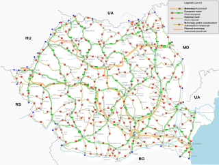
Public roads in Romania are ranked according to importance and traffic as follows:

<span class="mw-page-title-main">European route E60</span> Second-longest road in the International E-road network

European route E 60 is the second-longest road in the International E-road network and runs 8,200 km (5,100 mi), from Brest, France, to Irkeshtam, Kyrgyzstan.

<span class="mw-page-title-main">Road hierarchy</span> Hierarchy in road traffic

The road hierarchy categorizes roads according to their functions and capacities. While sources differ on the exact nomenclature, the basic hierarchy comprises freeways, arterials, collectors, and local roads. Generally, the functional hierarchy can more or less correspond to the hierarchy of roads by their owner or administrator.

<span class="mw-page-title-main">European route E75</span> Road in trans-European E-road network

European route E 75 is part of the International E-road network, which is a series of main roads in Europe.

<span class="mw-page-title-main">Controlled-access highway</span> Highway designed for high-speed, regulated traffic flow

A controlled-access highway is a type of highway that has been designed for high-speed vehicular traffic, with all traffic flow—ingress and egress—regulated. Common English terms are freeway, motorway, and expressway. Other similar terms include throughway or thruway and parkway. Some of these may be limited-access highways, although this term can also refer to a class of highways with somewhat less isolation from other traffic.

<span class="mw-page-title-main">European route E65</span> Road in trans-European E-road network

European route E65 is a north-south Class-A European route that begins in Malmö, Sweden and ends in Chania, Greece. The road is about 4,400 km (2,700 mi) in length.

<span class="mw-page-title-main">M1 motorway (Hungary)</span> Road in Hungary

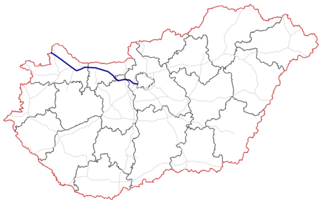
The M1 motorway is a toll motorway in northwestern Hungary, connecting Budapest to Győr and Vienna. The first section of the motorway opened in the 1970s, reaching the Austrian border at Hegyeshalom in 1996. It follows the route of the old Route 1 one-lane highway.

<span class="mw-page-title-main">M7 motorway (Hungary)</span> Road in Hungary

The M7 motorway is a Hungarian motorway which runs from Budapest towards the Croatian border at Letenye, reaching Székesfehérvár, then Siófok, a town on Lake Balaton, and the city of Nagykanizsa in the southwest of the country.

<span class="mw-page-title-main">Highways in Hungary</span> Numbered system of roads in Hungary

Controlled-access highways in Hungary are dual carriageways, grade separated with controlled-access, designed for high speeds. The legislation amendments define two types of highways: motorways and expressways.

<span class="mw-page-title-main">M30 motorway (Hungary)</span> Road in Hungary

The M30 motorway is a Hungarian motorway that connects the M3 motorway to the Slovak R4 expressway near the border town of Tornyosnémeti via Miskolc, forming part of European routes E71 and E79. The first section opened to the public in 2002, and reached the border area in October 2021.

<span class="mw-page-title-main">European route E79</span> Road in trans-European E-road network

European route E 79 is a road part of the International E-road network. It begins in Miskolc, Hungary and ends in Thessaloniki, Greece, also running through Romania and Bulgaria. The road is 1,300 km (810 mi) long.

<span class="mw-page-title-main">European route E73</span> Road in trans-European E-road network

European route E73 forms part of the United Nations International E-road network, connecting Hungary and eastern Croatia to Bosnia and Herzegovina and the Adriatic Sea in the vicinity of the port of Ploče. This 679-kilometre (422 mi) route is also designated as the Pan-European Corridor Vc, a branch of the fifth Pan-European corridor. The route largely consists of two-lane roads with at-grade intersections, although in the 2000s, about a third of the route was upgraded to motorway standards. The remainder of the route is currently being upgraded in all the countries spanned. The longest part of this corridor goes through Bosnia and Herzegovina and is widely touted as a road instrumental to the development of the country. The road also serves as the shortest connection of the eastern and southern parts of Croatia.

<span class="mw-page-title-main">Roads in Serbia</span>

Roads in Serbia are the backbone of its transportation system and an important part of the European road network. The total length of roads in the country is 45,419 km, and they are categorized as "state roads" or "municipal roads". All state roads in Serbia are maintained by the public, nation-wide, road construction company JP Putevi Srbije.

<span class="mw-page-title-main">M4 motorway (Hungary)</span> Road in Hungary

M4 is a Hungarian expressway which will, upon completion, connect Budapest to Oradea and further Romanian cities. The route will travel in Hungary through Cegléd, Szolnok, Karcag, Püspökladány, Berettyóújfalu, and Nagykereki before reaching the Romanian border.

<span class="mw-page-title-main">European route E71</span> Road in trans-European E-road network

European route E 71 is a north-south Class-A intermediate European road route. It begins in Košice, Slovakia, passes through Budapest in Hungary, Zagreb in Croatia, and ends at Split in Croatia on the Adriatic Sea coast. The total length of the route is 1,016 km (631 mi). The E71 mostly consists of motorways, but considerable sections are either expressways or two-lane roads with at-grade intersections. Nearly all motorway sections of the E71 are tolled, using various toll collection systems including Electronic toll collection (ETC) and ticket systems. Individual segments of the E71 route are shared with several other European routes. The E71 section between Karlovac and Split is inconsistently physically signposted or marked on maps and route planning software. The E71 route has gradually been upgraded from a regular two-lane road to motorway standards since the 1970s; upgrades are still being carried out in some areas.

This article describes the highway systems available in selected countries.

The Zrinski Bridge or Zrínyi Bridge connects the Croatian A4 and the Hungarian M7 motorways, spanning the Mura River. As it also spans Hungarian–Croatian border, a joint border checkpoint is located north of the bridge. The bridge is located between Goričan interchange of the A4 motorway and the M70 motorway interchange of the M7. The bridge is a part of a major north–south transportation corridor in Croatia and Hungary and a part of European routes E65 and E71 as well as the Pan-European corridor Vb.

<span class="mw-page-title-main">M70 motorway (Hungary)</span> Road in Hungary

The M70 motorway is a motorway in Hungary, connecting the M7 motorway to the A5 motorway in Slovenia. The road is 21 km long and has a speed limit of 130 km/h. The last section was completed in 2006. After the opening of the last missing sections of the M7 on August 19, 2008, there is a direct motorway link from Budapest to Slovenia. The expressway originally consisted of two lanes between Letenye and Tornyiszentmiklós interchanges. As a four-lane, full profile motorway, it opened on December 13, 2019. It was built by the Colas Group.

<span class="mw-page-title-main">Via Carpathia</span> Transnational motorway in Europe

Via Carpathia is a planned transnational highway network connecting Klaipėda in Lithuania with Thessaloniki in Greece. It is currently planned to open in 2025.

References

  1. Állami Autópályakezelő Zrt. (ÁAK) (2013). "Az ÁAK által kezelt úthálózat részletes adatai (2013)". Archived from the original on 2015-03-23. Retrieved 2015-05-14.
  2. 1 2 "Az állami közúthálózatról - Országos közúthálózat hossza 2005-2022". magyarkozut.hu. 2023-12-22. Retrieved 2023-12-22.
  3. "UNECE document ECE/TRANS/SC.1/2016/03/Rev1 "European Agreement On Main International Traffic Arteries (AGR)"" (PDF). The United Nations Economic Commission for Europe. 1 November 2016. Retrieved 16 May 2020.