
Gualdo Tadino is an ancient town of Italy, in the province of Perugia in northeastern Umbria, on the lower flanks of Monte Penna, a mountain of the Apennines. It is 47 kilometres (29 mi) NE of Perugia.
Manerba del Garda is a town and comune in the province of Brescia, in Lombardy. It is located at the southwest side of the Lake Garda.

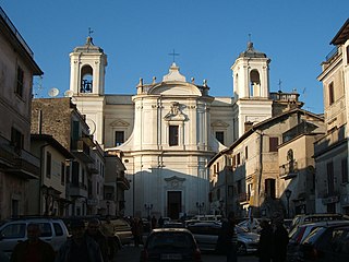
Archi is a town and comune in the province of Chieti, Abruzzo, southern Italy. It is part of the Valsangro mountain community.

Bugnara is a comune and village in the province of L'Aquila in the Abruzzo region of central Italy. In 2007, it was designated as one of the most beautiful villages in Italy, an association that notes small Italian towns of artistic and historical interest.

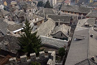
Calascio is a comune and village in the province of L'Aquila, in the Abruzzo region of central Italy. It is located in the Gran Sasso e Monti della Laga National Park.

Spongano is a town and comune in the province of Lecce, in the Apulia region of south-east Italy. It is located among the olive groves of Puglia's Salento, and retains its rural character while being just a few minutes to the Adriatic Sea. The rocky shore provides hidden coves interrupted by sandy beaches and reefs. The town bears witness to humanity's prehistoric presence with the dolmen called Piedi Grandi along with other megaliths and mehir.

Romano di Lombardia is a comune (municipality) in the Province of Bergamo in the Italian region of Lombardy, located about 45 kilometres (28 mi) east of Milan and about 20 kilometres (12 mi) southeast of Bergamo. It received the honorary title of city with a presidential decree on September 17, 1962.

Mondolfo is a comune (municipality) in the Province of Pesaro e Urbino in the Italian region Marche, located about 35 kilometres (22 mi) northwest of Ancona and about 25 kilometres (16 mi) southeast of Pesaro, on the Adriatic Sea.

Mogliano is a comune (municipality) in the Province of Macerata in the Italian region Marche, located about 50 kilometres (31 mi) south of Ancona and about 13 kilometres (8 mi) south of Macerata.

Vicopisano is a comune (municipality) in the Province of Pisa in the Italian region Tuscany, located about 50 kilometres (31 mi) west of Florence and about 15 kilometres (9 mi) east of Pisa. It occupies the former valley of the Arno River, bounded by the Monte Pisano from north.

Castellina in Chianti is a comune (municipality) of c. 2,800 inhabitants in the province of Siena, in the Italian region Tuscany, located about 35 kilometres (22 mi) south of Florence and about 15 kilometres (9 mi) northwest of Siena. It is part of the Chianti Hills, between the valleys of the Arbia, Pesa and Elsa rivers.

Piancastagnaio is a comune (municipality) in the Province of Siena in the Italian region Tuscany, located about 110 kilometres (68 mi) southeast of Florence and about 60 kilometres (37 mi) southeast of Siena.

Castell'Azzara is a comune (municipality) in the Province of Grosseto in the Italian region Tuscany, located about 120 kilometres (75 mi) southeast of Florence and about 50 kilometres (31 mi) east of Grosseto.

Gavorrano is a mountain-side comune (municipality) in the Province of Grosseto in the western Italian region of Tuscany, located about 100 km (62 mi) southwest of Florence and about 25 km (16 mi) northwest of Grosseto. Gavorrano borders the municipalities of Castiglione della Pescaia, Grosseto, Massa Marittima, Roccastrada and Scarlino.

Semproniano is a comune (municipality) in the Province of Grosseto in the Italian region of Tuscany, about 120 kilometres (75 mi) south of Florence and about 35 kilometres (22 mi) east of Grosseto.
Vicovaro is a comune (municipality) in the Metropolitan City of Rome in the Italian region Lazio, located about 45 kilometres (28 mi) northeast of Rome.

San Salvatore Telesino is a comune (municipality) in the Province of Benevento in the Italian region Campania, located about 50 kilometres (31 mi) northeast of Naples and about 25 kilometres (16 mi) northwest of Benevento.
Militello in Val di Catania is a comune (municipality) in the Metropolitan City of Catania in the Italian region Sicily, located about 160 kilometres (99 mi) southeast of Palermo and about 35 kilometres (22 mi) southwest of Catania, on the last slopes of the Hyblaean Mountains. It has a railway station on the line Catania-Gela.
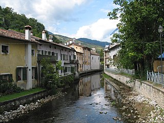
Polcenigo is a comune (municipality) in the Province of Pordenone in the Italian region Friuli-Venezia Giulia, located about 110 kilometres northwest of Trieste, 95 kilometres (59 mi) north of Venice and about 14 kilometres (9 mi) northwest of Pordenone.
Vogogna is a comune (municipality) at the heart of the Val d’Ossola in the Province of Verbano Cusio Ossola, Piedmont, Italy, about 20 kilometres (12 mi) north-west of Verbania. The municipality is centred on the town of Vogogna and extends over an area of 15.28 square kilometres (5.90 sq mi), partly within the Val Grande National Park; the elevation varies between 211 and 2,018 metres above sea-level. Outlying settlements (frazioni) within the municipality include Prata, Dresio and Genestredo.


