
Fortuna Foothills is a census-designated place (CDP) in Yuma County, Arizona, United States. The population was 26,265 at the 2010 census. It is part of the Yuma Metropolitan Statistical Area. Development of the area began in the 1960s, when local developer Hank Schechert purchased 3,000 acres east of Yuma.

Desert View Highlands is a census-designated place (CDP) in Los Angeles County, California, United States. The population was 2,360 at the 2010 census, up from 2,337 at the 2000 census. It is completely surrounded by the City of Palmdale.

Cimarron Hills is a census-designated place (CDP) in El Paso County, Colorado, United States. The population was 16,161 at the 2010 census. The CDP is unincorporated, and it, along with a small industrial and residential area which lies east of Marksheffel Rd., are completely surrounded by the city of Colorado Springs, while not actually being part of the city.
Broadview Park is a census-designated place (CDP) in Broward County, Florida, United States. The population was 7,125 at the 2010 census.

Glenvar Heights is a census-designated place (CDP) and neighborhood in Miami-Dade County, Florida, United States. The population was 16,898 at the 2010 census. The zip codes serving Glenvar Heights are 33173, 33143, and 33155.
Scott Lake is a neighborhood in Miami Gardens, Florida, United States. It was formerly its own census-designated place. The population was 14,401 at the 2000 census.

Tavernier is a census-designated place (CDP) and unincorporated community in Monroe County, Florida, United States on Key Largo, the largest island in the upper Florida Keys. Tavernier's population was 2,173 at the 2000 census.
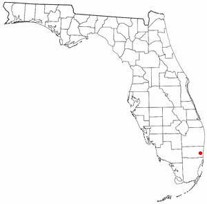
Fremd Village-Padgett Island was a census-designated place (CDP) in Palm Beach County, Florida, United States. The population was 2,264 at the 2000 census.

Honomū is a census-designated place (CDP) in Hawaiʻi County, Hawaii, United States. The population was 509 at the 2010 census, down from 541 at the 2000 census.

Coyne Center is a census-designated place (CDP) in Rock Island County, Illinois, United States. The population was 827 at the 2010 census.

Eastwood is a census-designated place (CDP) in Bossier Parish, Louisiana, United States. The population was 4,093 at the 2010 census. It is part of the Shreveport–Bossier City Metropolitan Statistical Area.

Lakeland is a hamlet in Onondaga County, New York, United States. The population was 2,786 at the 2010 census. The community name is derived from its location next to Onondaga Lake.

Northbrook is a census-designated place (CDP) in Hamilton County, Ohio, United States. The population was 10,668 at the 2010 census.

New Castle Northwest is a census-designated place (CDP) in Lawrence County, Pennsylvania, United States. The population was 1,413 at the 2010 census.

Maple Glen is a census-designated place (CDP) in Montgomery County, Pennsylvania, United States. The population was 6,742 at the 2010 census.
Groveton is a census-designated place (CDP) in Fairfax County, Virginia, United States. The population was 14,598 at the 2010 census, down from 21,296 in 2000 due to a reduction in area. Located south of the city of Alexandria, it encompasses numerous neighborhoods including Groveton, Bucknell Manor and Stoneybrooke. Huntley Meadows Park, Fairfax County's largest park, is located in the southwest part of the CDP.

Birch Bay is a protected bay of the east shore of the Salish Sea, between Semiahmoo Bay and Lummi Bay; approximately 100 miles (160 km) north of Seattle and 35 miles (56 km) south of Vancouver, BC, Canada.

Fairlea is a census-designated place (CDP) in Greenbrier County, West Virginia, United States. The population was 1,747 at the 2010 census. Fairlea is the location of the annual West Virginia State Fair, held in August.

Holland is a census-designated place (CDP) in the town of Holland in Hampden County, Massachusetts, United States, comprising the town center and other populated areas in the eastern part of the town. The population was 1,464 at the 2010 census, out of a total 2,481 people in the town. It is part of the Springfield, Massachusetts Metropolitan Statistical Area.
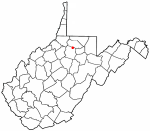
Enterprise is a census-designated place (CDP) in Harrison County, West Virginia, United States, along the West Fork River. The population was 961 at the 2010 census.
