Rockall Bank dispute

Last updated
Exclusive economic zones of the countries claiming an interest in the dispute. Rockall EEZ map-en.svg
Exclusive economic zones of the countries claiming an interest in the dispute.

Several states have claimed interests over the sea bed adjoining Rockall, an uninhabitable granite islet which is located within the exclusive economic zone (EEZ) of the United Kingdom. Ireland, Denmark, Iceland, and the United Kingdom have all made submissions to the commission set up under the United Nations Convention on the Law of the Sea (UNCLOS).

Contents

Overview

The United Nations Convention on the Law of the Sea states, "Rocks which cannot sustain human habitation or economic life of their own shall have no exclusive economic zone or continental shelf."

The convention was ratified by all four states in dispute over the Rockall Plateau – Iceland on 26 January 1985, Ireland on 21 January 1996, the United Kingdom on 25 July 1997 and Denmark on 16 November 2004.

The twenty-fourth session of the United Nations Commission on the Limits of the Continental Shelf (CLCS) was held in New York from 10 August to 11 September 2009. Iceland, [1] Ireland, [2] and the United Kingdom [3] have made submissions. Denmark was due to make a submission before the end of 2014. [4]

On 7 November 1988 the United Kingdom and Ireland agreed a delineation which ignores Rockall's existence and have granted exploration rights. [5] [6] This bilateral agreement is disputed by Iceland and by Denmark. [4]

In 1997, the UK Government declared that "The United Kingdom's fishery limits will need to be redefined based on St Kilda, since Rockall is not a valid base point for such limits under Article 121(3) of the Convention." This is the only example to date of a state voluntarily downgrading an insular feature to "a rock" and thus reducing the area of its claimed maritime zones. [7]

Rockall is within the Exclusive Economic Zone (EEZ) claimed by the United Kingdom. [8] [9] [10] In 1997, the UK ratified [11] the United Nations Convention on the Law of the Sea and thus relinquished any claim to an extension of its EEZ beyond the islet. The remaining issue is the status of the continental shelf rights of the surrounding ocean floor. These are the exclusive rights to exploit any resources on or under the ocean floor (oil, natural gas, etc.) and should not be confused with the EEZ, as continental shelf rights do not carry any privileges with regard to fisheries. Ownership of these rights in the Rockall area are disputed between the United Kingdom, Denmark (for the Faroe Islands), Ireland and Iceland.

Individual claims

Danish claim via Faroe Islands

The Faroe Islands are an autonomous country of the Kingdom of Denmark. Since 1948 they have had self-government in almost all matters except defence and foreign affairs. Consequently, their interests in Rockall are represented by Denmark. On their behalf, Denmark claims continental shelf rights in the Hatton-Rockall area. [12]

A communiqué issued by the Prime Minister's Office on 7 May 1985 announced the designation of not only the seabed in the immediate vicinity of the Faroes but also a vast area of the Rockall plateau to the south west. The press release which accompanied the communiqué indicated that the legal basis of this designation was the assumption that "the Faroe Islands are part of the microcontinent" formed by the "Faroes-Rockall Plateau", an "elevated plain with its summit in the Faroe Islands". [13]

Icelandic claim

Iceland does not claim the rock itself, considering it irrelevant as far as delimitation of EEZs and continental shelf is concerned. Iceland however claims an extended continental shelf in the Hatton-Rockall area. [12]

Despite its long history of human habitation into the 20th century, Iceland considers St. Kilda to be "a minuscule, effectively uninhabited, islet, categorized under article 121(3) of the Law of the Sea Convention". Furthermore, St. Kilda lies outside the British territorial sea limit. Therefore, it is not an "equitable basepoint for an equidistant line". [14]

Iceland ratified the United Nations Convention on the Law of the Sea in 1985; it was the first Western country to do so. A regulation was issued by the government in that same year outlining the area where Iceland claimed continental shelf rights for itself; the regulation [15] was based on legislation [16] from 1979 claiming for Iceland the exclusive right to research and exploitation of continental shelf-based resources within the limits of the Icelandic continental shelf. Regarding the Hatton-Rockall area, it claims the area within 60 nautical miles (110 km) from the foot of the continental shelf and assumes that the UK and Ireland cannot claim a continental shelf outside their EEZs. To its fullest extent, this area reaches about 700 nautical miles (1,300 km) to the south from Iceland's coast, which is further south than the United Kingdom's northernmost point.

In 2001, Iceland began working on its submission to the Commission on the Limits of the Continental Shelf; it was scheduled to finish in 2007. The most important aspect of this work is to survey the entire ocean floor in the areas claimed outside the EEZ and, in Iceland's case, a part of the area inside the EEZ as well. In all, 1.3 million square kilometres (380,000 square nautical miles) have been surveyed by Icelandic marine research institutions for this purpose, an area 13 times larger than the land area of Iceland. The commission does however not make proposals regarding areas that are claimed by two or more states unless they have already reached an agreement on its division. Therefore, Iceland's submission is expected to deal only with the area that just Iceland has claimed and not the Hatton-Rockall area. Iceland also hosted an informal meeting of all parties to the dispute in 2001. It was the first such meeting regarding the dispute where all four countries participated.

Irish claim

The Irish Naval Service vessel, LE Roisin, on routine patrol at Rockall, 230 nautical miles (430 km) off the north-west coast of Ireland, 12 October 2012 LE Roisin at Rockall.jpg
The Irish Naval Service vessel, LÉ Róisín, on routine patrol at Rockall, 230 nautical miles (430 km) off the north-west coast of Ireland, 12 October 2012

According to a Written Parliamentary Answer from the Irish Minister of Foreign Affairs on 14 June 1990, an agreement [5] was reached between the British and Irish governments on delimitation of the continental shelf between the two countries and that this included a line of delimitation across the Rockall Plateau. [17] As a result, a very extensive area under Irish jurisdiction, including part of the Rockall Trough and Plateau, is not disputed by the United Kingdom. No further negotiations were taking place in relation to the rock at the time.

More recently, on 11 June 2003, the Irish Minister for Communications, Marine and Natural Resources gave a Written Parliamentary Answer, stating: "Ireland claims an extended continental shelf ... up to more than 500 nautical miles (926 km), particularly in the Hatton–Rockall area". [18]

As the United Nations [19] has no mandate regarding issues of delimitation between neighbouring states and cannot consider an area under dispute without the agreement of all the parties concerned, Ireland has participated in informal discussions with Iceland and the Faroe Islands in an attempt to resolve the dispute before making its submission to the Commission.

Conferences

Reykjavík conference

Representatives from the UK, Ireland, Iceland, and Denmark, met in Reykjavík, Iceland in September 2007 [20] for negotiations over territorial rights over the continental shelf in the area. The final boundary will be determined by the United Nations Commission on the Limits of the Continental Shelf. The parties have until May 2009 to submit reports to the commission, which it will take into account when determining the boundary. The involved nations have the option of submitting separate reports, or a joint one.

Ownership of the rock itself did not form part of the negotiations. [21]

Copenhagen conference

In November 2007, talks were held in Copenhagen. Here a template for a deal was secured by Irish, Danish, British and Icelandic diplomats.

Dublin conference

As a follow-up to Copenhagen, the Government of Ireland was to host negotiations. They were due to commence in January 2008, but were postponed because of elections in the Faroe Islands. The talks are hoped to bring the four nations closer to reaching an agreement over the Rockall-Hatton basin. It is understood a final deal is not likely to be agreed at the Dublin meeting. [22] The Irish Minister for Foreign Affairs at the time, Dermot Ahern said

There have certainly been protracted talks, but that is not unusual when one considers the complexity of the issue at hand and the competing interests. However, there was some progress made at the last talks in Copenhagen. I believe further progress can be made in Dublin. The deadline is May 2009 so we have time on our hands. It is in the interests of Ireland, UK, Denmark and Iceland to come to a deal on the division of the seabed area. We have come to outline agreements in relation to other parts of our seabed in the Atlantic. There is no reason ultimately why we also can't do a deal on this protracted issue. Finding a deal is a significant challenge but the rewards are there for future generations from all four countries.

The latest conference between all four parties occurred in Reykjavik in May 2011 [23]

Related Research Articles

<span class="mw-page-title-main">Rockall</span> Uninhabited islet in the North Atlantic Ocean

Rockall is an uninhabitable granite islet in the North Atlantic Ocean. The United Kingdom claims that Rockall lies within its territorial sea and is part of its territory, but this claim is not recognised by Ireland. It and the nearby skerries of Hasselwood Rock and Helen's Reef are the only emergent parts of the Rockall Plateau. The rock was formed by magmatism as part of the North Atlantic Igneous Province during the Paleogene.

<span class="mw-page-title-main">United Nations Convention on the Law of the Sea</span> International maritime law

The United Nations Convention on the Law of the Sea (UNCLOS), also called the Law of the Sea Convention or the Law of the Sea Treaty, is an international agreement that establishes a legal framework for all marine and maritime activities. As of May 2023, 168 countries and the European Union are parties.

<span class="mw-page-title-main">Territorial waters</span> Coastal waters that are part of a sovereign states sovereign territory

Territorial waters are informally an area of water where a sovereign state has jurisdiction, including internal waters, the territorial sea, the contiguous zone, the exclusive economic zone, and potentially the extended continental shelf. In a narrower sense, the term is often used as a synonym for the territorial sea.

<span class="mw-page-title-main">Law of the sea</span> International law concerning maritime environments

Law of the sea is a body of international law governing the rights and duties of states in maritime environments. It concerns matters such as navigational rights, sea mineral claims, and coastal waters jurisdiction.

<span class="mw-page-title-main">Exclusive economic zone</span> Adjacent sea zone in which a state has special rights

An exclusive economic zone (EEZ), as prescribed by the 1982 United Nations Convention on the Law of the Sea, is an area of the sea in which a sovereign state has exclusive rights regarding the exploration and use of marine resources, including energy production from water and wind. EEZ does not define the ownership of any maritime features within the EEZ.

<span class="mw-page-title-main">Lomonosov Ridge</span> Underwater ridge of continental crust in the Arctic Ocean

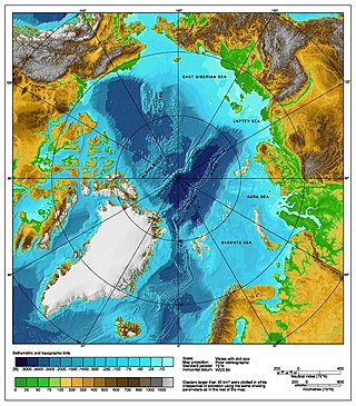
The Lomonosov Ridge is an unusual underwater ridge of continental crust in the Arctic Ocean. It spans 1,800 kilometres (1,100 mi) between the New Siberian Islands over the central part of the ocean to Ellesmere Island of the Canadian Arctic Archipelago. The ridge divides the Arctic Basin into the Eurasian Basin and the Amerasian Basin. The width of the Lomonosov Ridge varies from 60 to 200 kilometres. It rises 3,300 to 3,700 metres above the 4,200-metre (13,800 ft) deep seabed. The minimum depth of the ocean above the ridge is less than 400 metres (1,300 ft). Slopes of the ridge are relatively steep, broken up by canyons, and covered with layers of silt. It is an aseismic ridge.

<span class="mw-page-title-main">Rockall Basin</span> Bathymetric feature northwest of Scotland and Ireland

The Rockall Trough is a deep-water bathymetric feature to the northwest of Scotland and Ireland, running roughly from southwest to northeast, flanked on the north by the Rockall Plateau and to the south by the Porcupine Seabight. At the northern end, the channel is bounded by the Wyville-Thomson Ridge, named after Charles Wyville Thomson, professor of zoology at the University of Edinburgh and driving force behind the Challenger Expedition. At the southern end, the trough opens into the Porcupine abyssal plain. The Rockall Basin is a large sedimentary basin that lies beneath the trough. Both are named after Rockall, a rocky islet lying 301.4 km west of St Kilda.

<span class="mw-page-title-main">Territorial claims in the Arctic</span>

The Arctic consists of land, internal waters, territorial seas, exclusive economic zones (EEZs) and international waters above the Arctic Circle. All land, internal waters, territorial seas and EEZs in the Arctic are under the jurisdiction of one of the eight Arctic coastal states: Canada, Denmark, Finland, Iceland, Norway, Russia, Sweden and the United States. International law regulates this area as with other portions of Earth.

<span class="mw-page-title-main">Exclusive economic zone of Portugal</span> EEZ of Portugal

Portugal has the 5th largest exclusive economic zone (EEZ) within Europe, 3rd largest of the EU and the 20th largest EEZ in the world, at 1,727,408 km2.

<span class="mw-page-title-main">Brunei–Malaysia border</span> International border

The Brunei–Malaysia border divides the territory of Brunei and Malaysia on the island of Borneo. It consists of a 266 km (165 mi) land border and substantial lengths of maritime borders stretching from the coastline of the two countries to the edge of the continental shelf in the South China Sea.

Malaysia and Vietnam are two Southeast Asian countries with maritime boundaries which meet in the Gulf of Thailand and South China Sea. The two countries have overlapping claims over the continental shelf in the Gulf of Thailand. Both countries have, however, come to an agreement to jointly exploit the natural resources in the disputed area pending resolution of the dispute over sovereignty.

<span class="mw-page-title-main">Iceland–United Kingdom relations</span> Bilateral relations

Icelandic–British relations are foreign relations between Iceland and the United Kingdom.

<span class="mw-page-title-main">Arctic cooperation and politics</span> Between the eight Arctic nations

Arctic cooperation and politics are partially coordinated via the Arctic Council, composed of the eight Arctic nations: the United States, Canada, Iceland, Norway, Sweden, Finland, Russia, and Denmark with Greenland and the Faroe Islands. The dominant governmental power in Arctic policy resides within the executive offices, legislative bodies, and implementing agencies of the eight Arctic nations, and to a lesser extent other nations, such as United Kingdom, Germany, European Union and China. NGOs and academia play a large part in Arctic policy. Also important are intergovernmental bodies such as the United Nations and NATO.

The equidistance principle, or principle of equidistance, is a legal concept in maritime boundary claims that a nation's maritime boundaries should conform to a median line that is equidistant from the shores of neighboring nations. The concept was developed in the process of settling disputes in which the borders of adjacent nations were located on a contiguous continental shelf:

An equidistance line is one for which every point on the line is equidistant from the nearest points on the baselines being used. The equidistance principle is a methodology that has been endorsed by the United Nations Convention on the Law of the Sea but predates that treaty and has been used by the Supreme Court of the United States, states, and nations to establish boundaries equitably.

<span class="mw-page-title-main">Cyprus–Turkey maritime zones dispute</span> Ongoing political dispute in the Mediterranean

The Republic of Cyprus (Cyprus) and Turkey have been engaged in a dispute over the extent of their exclusive economic zones (EEZ), ostensibly sparked by oil and gas exploration in the area. Turkey objects to Cypriot drilling in waters that Cyprus has asserted a claim on. The present maritime zones dispute touches on the perennial Cyprus and Aegean disputes; Turkey is the only member state of the United Nations that does not recognise Cyprus, and is one of the countries which are not signatory to the United Nations Convention on the Law of the Sea, which Cyprus has signed and ratified.

<span class="mw-page-title-main">East China Sea EEZ disputes</span>

There are disputes between China, Japan, Taiwan and South Korea over the extent of their respective exclusive economic zones (EEZs) in the East China Sea.

<span class="mw-page-title-main">Peanut Hole</span> Area in the Sea of Okhotsk

The International zone of the Sea of Okhotsk, known by its nickname Peanut Hole, was an area of open ocean at the center of the Sea of Okhotsk until 2014. From 1991 to 2014 its status was the subject of international disputes, although since March 2014 the Peanut Hole's seabed and subsoil is legally part of the continental shelf of Russia.

<span class="mw-page-title-main">Exclusive economic zone of Australia</span> Maritime boundary

Australia's exclusive economic zone (EEZ) was declared on 1 August 1994 and extends from 12 to 200 nautical miles from the coastline of Australia and its external territories, except where a maritime delimitation agreement exists with another state. To the 12 nautical-mile boundary is Australia's territorial waters. Australia has the third-largest exclusive economic zone, behind France and the United States but ahead of Russia, with the total area of 8,148,250 square kilometres (3,146,060 sq mi), which exceeds its land territory.

Spain's exclusive economic zone (EEZ) is the 30th largest in the world with 1,039,233 km2 (401,250 sq mi). It is mostly in the Atlantic Ocean and the Mediterranean Sea. This is approximately double the entire Spanish land area. Together the land and sea surface would account for approximately 0.3% of the world's land surface.

The exclusive economic zone (EEZ) of Ireland extends 200 miles (320 km) from the coast. Exclusive economic zones are areas of internationally-recognised rights to conduct certain activities on areas of the high seas but do not give any power over access to those areas, including over shipping or military matters.

References

  1. "The Icelandic Continental Shelf" (PDF). Retrieved 26 November 2009.
  2. "Hatton-Rockall Area Continental Shelf Submission of Ireland" (PDF). Retrieved 26 November 2009.
  3. "(UK submission) Submission to the Commission on the Limits of the Continental Shelf" (PDF). Retrieved 26 November 2009.
  4. 1 2 "Permanent Mission of Denmark to the United Nations" (PDF). Retrieved 26 November 2009.
  5. 1 2 Brian Lenihan and Geoffrey Howe (7 November 1988). "Agreement concerning the delimitation of areas of the continental shelf between the two countries" (PDF). United Nations. Retrieved 26 November 2009.
  6. "Protocol Supplementary to the Agreement between the Government of Ireland and the Government of the United Kingdom concerning the Delimitation of Areas of the Continental Shelf between the two Countries (7 November 1988)8 December 1992" (PDF). Retrieved 2010-08-24.
  7. Maritime Boundary Disputes, Settlement Processes, and the Law of the Sea By Seoung-Yong Hong, Jon M. Van Dyke, Martinus Nijhoff 2009 ISBN   978-90-04-17343-9 (p. 29)
  8. Symmons, Clive (1998). "Ireland and the Rockall Dispute: An Analysis of Recent Developments" (PDF). Durham University. Retrieved 20 October 2012.
  9. "EEZ of the UK". Seaaroundus.org. Retrieved 2010-08-24.
  10. "EEZ of Ireland". Seaaroundus.org. Retrieved 2010-08-24.
  11. "Statutory Instrument 1997 No. 1750 – The Fishery Limits Order 1997". Opsi.gov.uk. Retrieved 2010-08-24.
  12. 1 2 Clive R. Symmons (April 1986). "The Rockall Dispute Deepens: An Analysis of Recent Danish and Icelandic Actions". The International and Comparative Law Quarterly. 35 (2): 344–373. doi:10.1093/iclqaj/35.2.344. JSTOR   759232 . Retrieved 22 March 2021.
  13. Symmons, Clive R (April 1986). "The Rockall Dispute Deepens: An Analysis of Recent Danish and Icelandic Actions". International & Comparative Law Quarterly. 35 (2): 344. doi:10.1093/iclqaj/35.2.344 . Retrieved 2009-03-05. Published online by Cambridge University Press 17 Jan 2008
  14. Symmons, Clive Ralph (2000). Ireland and the Law of the Sea. Dublin: Round Hall Sweet & Maxwell. p. 236 & 397. ISBN   1-85800-168-4.
  15. "Reglugerd.is". Reglugerd.is. Retrieved 2010-08-24.
  16. "Althings.is". Althingi.is. Retrieved 2010-08-24.
  17. "Written Answers — Rockall Ownership". Dáil Éireann. 399. 14 June 1990. Retrieved 2007-08-01.
  18. "Written Answers — Exploration Rights". Dáil Éireann. 568. 11 June 2003. Retrieved 2007-08-01.
  19. "Commission on the Limits of the Continental Shelf" . Retrieved 2007-08-01.
  20. "Parliamentary Debates". Written Answers. – UN Conventions. Dáil Éireann. 23 October 2007. Retrieved 2009-09-19.
  21. Ross, John (2007-09-27). "Why a barren rock in the Atlantic is the focus of an international battle of wills". The Scotsman . Retrieved 2007-09-27.
  22. "Government to host Rockall talks". RTÉ News . 2007-12-29. Retrieved 2007-07-29.
  23. "Ministry for foreign affairs (Icelandic)" . Retrieved 2017-01-19.