Lindi Town is a southern Tanzanian coastal town and regional capital of Lindi Region located at the far end of Lindi Bay, on the Indian Ocean in southeastern Tanzania. The town is 450 kilometres (280 mi) south of Dar es Salaam and 105 km (65 mi) north of Mtwara, the southernmost coastal town in Tanzania, and gives its name to the surrounding Lindi Region, one of the largest regions in Tanzania and one of most sparsely populated regions of the country.

The Eastern Guinean forests are a tropical moist broadleaf forest ecoregion of West Africa.
The Mahenge Mountains are a mountain range in Ulanga District, Morogoro Region, Tanzania. The town of Mahenge is located in the northeastern mountains. The mountains are southeast of Iringa, in the Eastern miombo woodlands ecoregion.
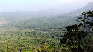
Anaimalai Tiger Reserve, earlier known as Indira Gandhi Wildlife Sanctuary and National Park and as Anaimalai Wildlife Sanctuary, is a protected area in the Anaimalai Hills of Pollachi and Valparai taluks of Coimbatore District and Udumalaipettai taluk in Tiruppur District, Tamil Nadu, India. The Tamil Nadu Environment and Forests Department by a notification dated 27 June 2007, declared an extent of 958.59 km2 that encompassed the erstwhile IGWLS&NP or Anaimalai Wildlife Sanctuary, as Anaimalai Tiger Reserve under the Wildlife Protection Act, 1972. According to the National Tiger Conservation Authority, the Reserve presently includes a core area of 958.59 km2 and buffer/peripheral area of 521.28 km2 forming a total area of 1479.87 km2.
The Viphya Mountains, also known as the Viphya Plateau or Viphya Highlands, are a mountain range in Malawi's Northern Region.
The Kipengere Range, also known as the Livingstone Mountains, lies entirely in Njombe Region in southwest Tanzania at the northern end of Lake Nyasa. Near Lake Nyasa they are known as the Kinga Mountains. It is a plateau-like ridge of mountains running southeastwards from the basin of the Great Ruaha River in the north to that of the Ruhuhu River in the south, and forms part of the eastern escarpment of the East African Rift. The range is mostly clad in montane grasslands, renowned for their botanical diversity and displays of flowers, with montane evergreen forests mostly in stream valleys.

The Narmada Valley dry deciduous forests are a tropical dry forest ecoregion of central India. The ecoregion lies mostly in Madhya Pradesh state, but extends into portions of Chhattisgarh, Maharashtra, Karnataka and Uttar Pradesh states.
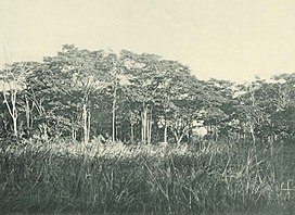
The Amani Nature Reserve is a protected area located within the Muheza and Korogwe Districts in the Tanga Region of Tanzania, in tropical East Africa.

Milicia excelsa is a tree species from the genus Milicia of the family Moraceae. It is one of two species yielding timber commonly known as African teak, iroko, intule, kambala, moreira, mvule, odum and tule.

The Hoollongapar Gibbon Sanctuary, formerly known as the Gibbon Wildlife Sanctuary or Hollongapar Reserve Forest, is an isolated protected area of evergreen forest located in Assam, India. The sanctuary was officially constituted and renamed in 1997. Set aside initially in 1881, its forests used to extend to the foothills of the Patkai mountain range.

The Southern Zanzibar-Inhambane coastal forest mosaic, also known as the Southern Swahili coastal forests and woodlands, is a tropical moist broadleaf forest ecoregion of eastern Africa. It is a southern variation of Northern Zanzibar-Inhambane coastal forest mosaic. The ecoregion supports habitats of forest, savanna and swamps. The southern portion of the ecoregion is not as well studied due to the 1977-1992 civil war in Mozambique.

(TANAPA))
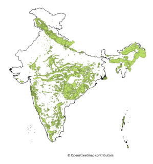
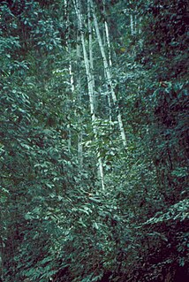
Tropical evergreen forests of India are found in the Andaman and Nicobar Islands, as Western Ghats, which fringe the Arabian Sea, the coastline of peninsular India, and the greater Assam region in the north-east. Small remnants of evergreen forest are found in Odisha state. Semi-evergreen forest is more extensive than the evergreen formation partly because evergreen forests tend to degrade to semi-evergreen with human interference. There are substantial differences between the three major evergreen forest regions.
The Lukuledi is a river in The United Republic Of Tanzania, south-eastern region of Africa. With a total length of 160 km, it rises from the boundary between the Lindi and Mtwara regions.

The Bugoma Forest is a protected tropical forest that is situated southwest of Hoima and northeast of Kyenjojo towns, and east of Lake Albert, in the Hoima district of western Uganda. It was gazetted in the 1930s and came under the mandate of the National Forestry Authority (NFA) in 2003. Its surface area is given as between 41,142 hectares (411.42 km2) and 65,000 hectares (650 km2).

The Rubeho Mountains are a mountain range in central Tanzania. The mountains in Dodoma and Morogoro regions, southeast of Tanzania's capital Dodoma. The Rubeho Mountains are part of the Eastern Arc Mountains, and are home to a biodiverse community of flora and fauna with large numbers of endemic species.
The Ukaguru Mountains are a mountain range in central Tanzania. The mountains are in Morogoro region, east of Tanzania's capital Dodoma. The mountains are named for the Kaguru people. The Ukaguru Mountains are part of the Eastern Arc Mountains, and are home to a biodiverse community of flora and fauna with large numbers of endemic species.
The Nguu Mountains are a mountain range in Tanga Region of Tanzania. The Nguu Mountains are part of the Eastern Arc Mountains. The mountains are covered in woodland, grassland, and forest.

The Victoria Basin forest-grassland mosaic is an ecoregion that lies mostly in Uganda and extends into neighboring countries. The ecoregion is centered north and west of Lake Victoria, with an outlier on the border of Ethiopia and South Sudan.

Khadim Nagar National Park is a major national park and nature reserve in Bangladesh. The park is located at Sylhet Sadar Upazila, Sylhet District in the North-East region of the country. It is located mainly on the Hills and is surrounded by Kalagool, Bhurjan and Goolni tea estates. Khadim Nagar National Park covers approximately 679 ha (6.79 km2) of evergreen forests Biome. The British colonial people cleared the land for extensive tea plantations. After 1950 tree plantations of teak, Garjan, Bamboo, Champa, Agar, Akashmoni, Eucalyptus and Acacia Mangium was carried out by Forest Department. The Forest was declared as national park by the Bangladesh government on 13 April 2006 under the Bangladesh wildlife (Preservation) Amendment Act of 1947. The present forest is divided into 6 forest working circles. The forest area has LR plantations- 380 Ha, SR Plantations-10 Ha, Bamboo Plantations-150Ha, Cane plantations-258Ha and Agar Plantations-40ha.