Roosevelt, Utah

Last updated

Roosevelt, Utah
Duchesne County Utah incorporated and unincorporated areas Roosevelt highlighted.svg
Location in Duchesne County and the state of Utah
Coordinates: 40°17′55″N109°59′39″W / 40.29861°N 109.99417°W / 40.29861; -109.99417
Country United States
State Utah
County Duchesne
Founded1905
Named for Theodore Roosevelt
Government
  MayorJep Young
  MayorParker Crum
Area
[1]
  Total6.76 sq mi (17.50 km2)
  Land6.76 sq mi (17.50 km2)
  Water0.00 sq mi (0.00 km2)
Elevation
5,095 ft (1,553 m)
Population
 (2020)
  Total6,747
  Density998.08/sq mi (385.54/km2)
Time zone UTC-7 (Mountain (MST))
  Summer (DST) UTC-6 (MDT)
ZIP code
84066
Area code 435
FIPS code 49-64670 [2]
GNIS feature ID1431989 [3]
Website www.rooseveltcity.com

Roosevelt is a city in Duchesne County, Utah, United States. The population was 6,747 at the 2020 census, [4] an increase of 701 (11.6%) from the 6,046 counted in the 2010 census. [5]

Contents

The proper pronunciation of the city's name /ˈrzəvɛlt/ ROH-zə-velt is based on how President Theodore Roosevelt pronounced his name: according to the man himself, "pronounced as if it was spelled 'Rosavelt.'" [6]

Roosevelt is home to a regional campus location of Utah State University.

Geography

The city is on the eastern edge of Duchesne County, adjacent to the border with Uintah County. The town of Ballard borders Roosevelt to the east. U.S. Routes 40 and 191 pass through Roosevelt as Main Street, leading east 30 miles (48 km) to Vernal and west 28 miles (45 km) to Duchesne.

According to the United States Census Bureau, the city of Roosevelt has a total area of 5.6 square miles (14.4 km2), all land. [5]

Climate

According to the Köppen Climate Classification system, Roosevelt has a cold semi-arid climate, abbreviated "BSk" on climate maps. The hottest temperature recorded in Roosevelt was 105 °F (40.6 °C) on July 18, 1998, while the coldest temperature recorded was −47 °F (−43.9 °C) on February 6, 1989. [7]

Climate data for Roosevelt, Utah, 1991–2020 normals, extremes 1986–present
MonthJanFebMarAprMayJunJulAugSepOctNovDecYear
Record high °F (°C)59
(15)
67
(19)
80
(27)
88
(31)
99
(37)
104
(40)
105
(41)
101
(38)
99
(37)
87
(31)
73
(23)
62
(17)
105
(41)
Mean maximum °F (°C)43.8
(6.6)
54.0
(12.2)
70.8
(21.6)
80.3
(26.8)
88.3
(31.3)
96.5
(35.8)
100.0
(37.8)
97.4
(36.3)
81.7
(27.6)
80.8
(27.1)
62.7
(17.1)
48.1
(8.9)
100.4
(38.0)
Mean daily maximum °F (°C)30.6
(−0.8)
39.8
(4.3)
56.4
(13.6)
65.7
(18.7)
75.5
(24.2)
86.6
(30.3)
93.2
(34.0)
90.4
(32.4)
81.0
(27.2)
66.3
(19.1)
48.9
(9.4)
33.5
(0.8)
64.0
(17.8)
Daily mean °F (°C)16.3
(−8.7)
25.1
(−3.8)
38.9
(3.8)
47.3
(8.5)
56.8
(13.8)
65.7
(18.7)
72.4
(22.4)
70.0
(21.1)
60.9
(16.1)
47.8
(8.8)
33.3
(0.7)
19.9
(−6.7)
46.2
(7.9)
Mean daily minimum °F (°C)2.1
(−16.6)
10.4
(−12.0)
21.7
(−5.7)
29.0
(−1.7)
38.1
(3.4)
44.8
(7.1)
51.6
(10.9)
49.7
(9.8)
40.8
(4.9)
29.4
(−1.4)
17.6
(−8.0)
6.3
(−14.3)
28.5
(−2.0)
Mean minimum °F (°C)−15.1
(−26.2)
−7.2
(−21.8)
8.6
(−13.0)
17.1
(−8.3)
26.3
(−3.2)
35.4
(1.9)
42.7
(5.9)
41.2
(5.1)
29.8
(−1.2)
17.4
(−8.1)
4.9
(−15.1)
−10.6
(−23.7)
−18.3
(−27.9)
Record low °F (°C)−35
(−37)
−47
(−44)
−6
(−21)
8
(−13)
18
(−8)
27
(−3)
37
(3)
32
(0)
21
(−6)
−4
(−20)
−9
(−23)
−40
(−40)
−47
(−44)
Average precipitation inches (mm)0.55
(14)
0.39
(9.9)
0.52
(13)
0.74
(19)
0.82
(21)
0.48
(12)
0.45
(11)
0.63
(16)
1.04
(26)
0.87
(22)
0.38
(9.7)
0.54
(14)
7.41
(187.6)
Average snowfall inches (cm)5.2
(13)
3.4
(8.6)
1.1
(2.8)
0.7
(1.8)
0.0
(0.0)
0.0
(0.0)
0.0
(0.0)
0.0
(0.0)
0.0
(0.0)
0.2
(0.51)
0.6
(1.5)
5.2
(13)
16.4
(41.21)
Average extreme snow depth inches (cm)5.3
(13)
3.8
(9.7)
1.4
(3.6)
0.0
(0.0)
0.0
(0.0)
0.0
(0.0)
0.0
(0.0)
0.0
(0.0)
0.0
(0.0)
0.2
(0.51)
0.7
(1.8)
4.3
(11)
6.2
(16)
Average precipitation days (≥ 0.01 in)4.04.84.05.66.43.34.05.75.76.14.24.958.7
Average snowy days (≥ 0.1 in)2.92.20.50.30.00.00.00.00.00.10.43.39.7
Source 1: NOAA [8]
Source 2: National Weather Service [7]

Demographics

Historical population
CensusPop.Note
1910 820
1920 1,05428.5%
1930 1,051−0.3%
1940 1,26420.3%
1950 1,62828.8%
1960 1,81211.3%
1970 2,00510.7%
1980 3,84291.6%
1990 3,9151.9%
2000 4,2999.8%
2010 6,04640.6%
2020 6,74711.6%
U.S. Decennial Census [9]

2020 census

Demographic and housing characteristics data from the 2020 Census will be available May 2023. [10]

2000 census

As of the census [2] of 2000, there were 4,299 people, 1,380 households, and 1,095 families residing in the city. The population density was 818.6 people per square mile (316.2/km2). There were 1,566 housing units at an average density of 298.2 per square mile (115.2/km2). The racial makeup of the city was 86.58% White American, 0.19% Black or African American, 8.14% Native American, 0.21% Asian American, none Pacific Islander American, 1.74% from other races, and 3.14% from two or more races. Hispanic or Latino of any race were 3.88% of the population.

There were 1,380 households, out of which 51.0% had children under the age of 18 living with them, 60.8% were married couples living together, 14.2% had a female householder with no husband present, and 20.6% were non-families. 16.7% of all households were made up of individuals, and 5.9% had someone living alone who was 65 years of age or older. The average household size was 3.12 and the average family size was 3.51.

In the city, the population was spread out, with 39.5% under the age of 18, 10.7% from 18 to 24, 25.4% from 25 to 44, 16.1% from 45 to 64, and 8.3% who were 65 years of age or older. The median age was 25 years. For every 100 females, there were 94.0 males. For every 100 females age 18 and over, there were 88.4 males.

The median income for a household in the city was $29,190, and the median income for a family was $32,328. Males had a median income of $32,117 versus $18,043 for females. The per capita income for the city was $11,945. About 19.2% of families and 22.1% of the population were below the poverty line, including 26.7% of those under age 18 and 10.1% of those age 65 or over.

2015

As of 2015 the largest self-reported ancestry groups in Roosevelt, Utah are: [11]

Largest ancestries (2015)Percent
English Flag of England.svg 25.0%
American Flag of the United States.svg 8.9%
German Flag of Germany.svg 7.2%
Irish Flag of Ireland.svg 5.1%
Danish Flag of Denmark.svg 4.4%
Scottish Flag of Scotland.svg 3.5%
Swedish Flag of Sweden.svg 2.5%
Italian Flag of Italy.svg 2.2%
Norwegian Flag of Norway.svg 1.4%
Welsh Flag of Wales (1959-present).svg 0.9%

History

In 1905, by an act of Congress, the unallotted land of the Ute Indian Reservation was opened to homesteading. Several thousand hopeful 20th-century pioneers congregated in Provo and Grand Junction with the hope of successfully drawing lots for a homestead in a fertile region of the soon-to-be-opened lands. Throughout the fall and winter of 1905–06, the settlers came to the Uinta Basin.

The town of Roosevelt was founded in early 1906 when Ed Harmston turned his homestead claim into a townsite and laid out plots. His wife named the prospective town in honor of the president of the United States, Theodore Roosevelt. Roosevelt was originally called Dry Gulch City, taking its name from a nearby gulch that only carries water during the early spring runoff season. Within a short time a store, a post office, and the Dry Gulch Irrigation Company were in business in the new town. In 1907, the Harmstons donated 2 acres (8,100 m2) of ground for the town's citizens to build a school. The first class had about fifteen pupils, who had to provide books from their homes. Roosevelt soon became the economic center for the area, eclipsing Myton and Duchesne.

Roosevelt is situated on U.S. Route 40 in the northeast corner of the state, south of the Uinta Mountains, at an elevation of 5,250 feet (1,600 m). The town was incorporated at a mass meeting of 44 citizens on 21 February 1913. From 1906 to 1914 Roosevelt was in Wasatch County, but in 1914 Duchesne County was formed from part of Wasatch County, and, as the largest town in the county, Roosevelt anticipated becoming the county seat. However, when the total county-wide vote came in, the seat went to Duchesne.

Economy

The population of Roosevelt is approximately 6,700 people, but the town serves as the business center for several times that number from the many small towns and farming communities in the area.

Roosevelt is located in an area of vast oil reserves spanning the northeast corner of Utah and extending into western Colorado. The town "booms" whenever oil prices go up and falls on harder times when oil prices decrease. The proposed Uinta Basin Rail project would build a new railroad line into Roosevelt for transporting oil drilled in the area.

The city used to have an oil refinery, "Plateau", named for the geographic location of the area, the Colorado Plateau. The oil from this area is known as "Uinta Basin Black Wax Crude" and has to be refined differently than most types of oil. Those in the oil business and land owners who profit from oil shares indicated during the high oil prices of 2005–2006 that refineries were cutting their profits by limiting the amount of Uinta Basin Black Wax they would refine.

Various types of farming, including beef cattle, sheep, pigs, horses, honey and hay, are prevalent in the outlying areas around town.

Roosevelt is also home of the only hospital in the county, Uintah Basin Medical Center.

Education

It is within the Duchesne County School District.

Roosevelt has become the county's educational center with Union High School, Uintah Basin Technical College, and Utah State University's Uintah Basin Regional Campus all located there. Union High School is on the east end of town and straddled the border between Duchesne and Uintah Counties, thus the name "Union".

Union High School was then partially demolished in favor of a newly built school; still named Union, but located on a road just behind the old school and a little further west. It was still on the east end of town but not crossing the border how it was. This new school was necessary as the old one could barely accommodate all of the students and was unlikely to have enough space for the next generations to come.

Roosevelt is part of the Duchesne School District. [12] Other schools in the area include: Eagle View Elementary (Public/K-8), East Elementary School (Public/K-5), Kings Peak Elementary (Public/K-5),Centennial Elementary (Public/K-5), Roosevelt Junior High School (Public/6-8), and Thompsen School (Public/3-12).

Religion and local culture

The Church of Jesus Christ of Latter-day Saints is the dominant religious denomination in Roosevelt, with three stake centers in town; the community also includes Roman Catholic, Christian Assembly of God, Baptist, Jehovah's Witnesses, and other smaller denomination congregations.

Located near the Uintah/Ouray Indian Reservation headquarters of Fort Duchesne, Roosevelt is a multicultural and polyethnic community, with Caucasians and Native Americans being the most numerous. Roosevelt is situated in lands designated as the Uintah and Ouray Indian Reservation and there are many Pow-Wows and Indian Ceremonies held throughout the summer and fall months.

The UBIC (Uintah Basin in Celebration) is Roosevelt's annual celebration. What started in the early part of the century as a yearly display of the latest in farming and industrial technology has developed into a yearly gala complete with parade, talent show, concerts, and dances.

Notable people

See also

Related Research Articles

<span class="mw-page-title-main">Daggett County, Utah</span> County in Utah, United States

Daggett County is a county in the northeastern corner of the U.S. state of Utah. As of the 2020 United States Census, the population was 935, making it the least populous county in Utah. Its county seat is Manila. The county was named for Ellsworth Daggett, the first surveyor-general of Utah. The small community of Dutch John, located near the state line with Colorado and Wyoming, became an incorporated town in January 2016.

<span class="mw-page-title-main">Duchesne County, Utah</span> County in Utah, United States

Duchesne County is a county in the northeast part of the U.S. state of Utah. As of the 2020 United States Census, the population was 19,596. Its county seat is Duchesne, and the largest city is Roosevelt.

<span class="mw-page-title-main">Wasatch County, Utah</span> County in Utah, United States

Wasatch County is a county in the U.S. state of Utah. As of the 2020 United States Census, the population was 34,788. Its county seat and largest city is Heber City. The county was named for a Ute word meaning "mountain pass" or "low place in the high mountains".

<span class="mw-page-title-main">Uintah County, Utah</span> County in Utah, United States

Uintah County is a county in the U.S. state of Utah. As of the 2020 United States Census the population was 35,620. Its county seat and largest city is Vernal. The county was named for the portion of the Ute Indian tribe that lived in the basin.

<span class="mw-page-title-main">Duchesne, Utah</span> City in and county seat of Duchesne County, Utah, United States

Duchesne is a city in and the county seat of Duchesne County, Utah, United States. The population was 1,588 at the 2020 census.

<span class="mw-page-title-main">Fort Duchesne, Utah</span> CDP in Utah, United States

Fort Duchesne is a census-designated place (CDP) in Uintah County, Utah, United States. The population was 714 at the 2010 census, an increase from the 2000 figure of 621.

<span class="mw-page-title-main">Naples, Utah</span> City in Utah, United States

Naples is a city in Uintah County, Utah, United States. The population was 2,282 at the 2020 United States Census. Naples was listed as a town in 2000; it has since been classified as a fifth-class city by state law.

<span class="mw-page-title-main">Vernal, Utah</span> City in Utah, United States

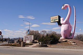
Vernal, the county seat and largest city in Uintah County, is in northeastern Utah, approximately 175 miles (280 km) east of Salt Lake City and 20 miles (32 km) west of the Colorado border. As of the 2020 census, the city population was 10,079. The population has since grown to 10,432 as of the 2022 population estimate.

<span class="mw-page-title-main">Whiterocks, Utah</span> CDP in Utah, United States

Whiterocks is a census-designated place (CDP) in Uintah County, Utah, United States. The population was 341 at the 2000 census, a slight increase over the 1990 population of 312.

<span class="mw-page-title-main">Ashley National Forest</span> National Forest in Utah and Wyoming, United States

Ashley National Forest is a National Forest located in northeastern Utah and southwestern Wyoming. Within the Forest's bounds are 1,382,346 acres (5,594 km2) of vast forests, lakes, and mountains, with elevations ranging from 6,000 to 13,500 feet. The forest covers portions of Daggett, Duchesne, Summit, Uintah, and Utah counties in Utah and Sweetwater County in Wyoming. Some of the most popular landmarks located in the forest include the Flaming Gorge National Recreation Area and the Uinta Mountains, which contains the highest mountain peak in Utah. The forest also includes 276,175 acres (1,117.64 km2), or about 60.5%, of the High Uintas Wilderness. The headquarters for the Ashley National Forest are located in Vernal, Utah with ranger district offices in Vernal; Duchesne, Utah; Roosevelt, Utah; Manila, Utah; and Green River, Wyoming.

<span class="mw-page-title-main">Uintah and Ouray Indian Reservation</span> Native American reservation in Utah, United States

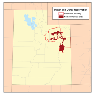
The Uintah and Ouray Indian Reservation is located in northeastern Utah, United States. It is the homeland of the Ute Indian Tribe, and is the largest of three Indian reservations inhabited by members of the Ute Tribe of Native Americans.

<span class="mw-page-title-main">Uinta Basin</span> Geologic structural basin in eastern Utah, US

The Uinta Basin is a physiographic section of the larger Colorado Plateaus province, which in turn is part of the larger Intermontane Plateaus physiographic division. It is also a geologic structural basin in eastern Utah, east of the Wasatch Mountains and south of the Uinta Mountains. The Uinta Basin is fed by creeks and rivers flowing south from the Uinta Mountains. Many of the principal rivers flow into the Duchesne River which feeds the Green River—a tributary of the Colorado River. The Uinta Mountains form the northern border of the Uinta Basin. They contain the highest point in Utah, Kings Peak, with a summit 13,528 feet above sea level. The climate of the Uinta Basin is semi-arid, with occasionally severe winter cold.

<span class="mw-page-title-main">Ute Indian Tribe of the Uintah and Ouray Reservation</span>

The Ute Indian Tribe of the Uinta and Ouray Reservation is a Federally Recognized Tribe of Indians in northeastern Utah, United States. Three bands of Utes comprise the Ute Indian Tribe: the Whiteriver Band, the Uncompahgre Band and the Uintah Band. The Tribe has a membership of more than three thousand individuals, with over half living on the Uintah and Ouray Indian Reservation. The Ute Indian Tribe operates its own tribal government and oversees approximately 1.3 million acres of trust land which contains significant oil and gas deposits.

In Section 203(a) of the Central Utah Project Completion Act, the United States Congress authorized a federally authorized and funded replacement project to replace the Uinta and Upalco Units of the Central Utah Project (CUP) which were not constructed. The replacement project is the Uinta Basin Replacement Project (UBRP). The UBRP will provide: 2,500 acre-feet (3,100,000 m3) of irrigation water; 3,000 acre-feet (3,700,000 m3) of municipal and industrial water; reduced wilderness impacts; increased instream flows; and improved recreation. Design work began in 2002. Construction began in 2004 and is anticipated to be completed in 2011. The Central Utah Water Conservancy District is responsible for construction. The United States Department of the Interior oversees funding and compliance with law and environmental regulation.

<span class="mw-page-title-main">Mountain Home, Utah</span> Unincorporated community in the state of Utah, United States

Mountain Home is an unincorporated community in central Duchesne County, Utah, United States, adjacent to the Uintah and Ouray Indian Reservation.

Strawberry is an unincorporated community in western Duchesne County, Utah, United States. Most of the inhabitants live along the Strawberry River between the Strawberry River pinnacles and Starvation Reservoir west of the city of Duchesne, the county seat of Duchesne County.

<span class="mw-page-title-main">Duchesne River</span> River in Utah, United States

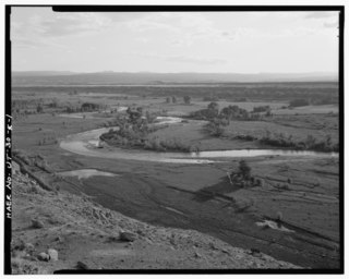
The Duchesne River, located in the Uintah Basin region of Utah in the western United States, is a tributary of the Green River. The watershed of the river covers the Northeastern corner of Utah. The Duchesne River is 115 miles (185 km) long, and drains a total land area of 3,790 square miles (9,800 km2).

Dragon is a ghost town in Uintah County, at the extreme eastern edge of Utah, United States. Founded in about 1888 as a Gilsonite mining camp, Dragon boomed in the first decade of the 20th century as the end-of-line town for the Uintah Railway. Although it declined when the terminus moved farther north in 1911, Dragon survived as the largest of the Gilsonite towns. It was abandoned after its mining operations stopped in 1938 and the Uintah Railway went out of business in 1939.

The Uinta Basin Rail project is a proposed 100-mile (160 km) rail line to connect the shale oil rich Uinta Basin region of eastern Utah to the national rail network. Numerous proposals have been made, some as far back as 1902, that are still under consideration. The current effort is a public-private partnership between a coalition of 7 counties in Utah, the Rio Grande Pacific Corporation and Drexel Hamilton Infrastructure Partners. The railroad is also backed by the Ute Tribe who hold a 5% stake in the project. If the rail line is built it will be the first major greenfield rail line built in the United States since the Chicago and North Western’s line to the Powder River Basin was built in the early 1980s. The Surface Transportation Board approved construction of the line in December 2021, but in August 2023, a Federal Appeals Court halted the project pending "a more fulsome explanation for the Board’s conclusion that the Railway’s transportation benefits outweighed the project’s environmental impacts".

<span class="mw-page-title-main">Uinta River</span>

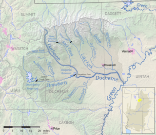
The Uinta River is a tributary of the Duchesne River flowing through Duchesne and Uintah counties in Utah, United States. Originating in the Uinta Mountains, the river flows southeast for about 60 miles (97 km) to join the Duchesne near Randlett. The Uinta is an important source of water for local irrigation. Its tributaries include the Whiterocks River, which joins it near Whiterocks, and the Dry Gulch Creek near Fort Duchesne.

References

  1. "2019 U.S. Gazetteer Files". United States Census Bureau. Retrieved August 7, 2020.
  2. 1 2 "U.S. Census website". United States Census Bureau . Retrieved January 31, 2008.
  3. "US Board on Geographic Names". United States Geological Survey. October 25, 2007. Retrieved January 31, 2008.
  4. "DP1 PROFILE OF GENERAL POPULATION AND HOUSING CHARACTERISTICS". U.S. Census Bureau. Retrieved February 8, 2024.
  5. 1 2 "Geographic Identifiers: 2010 Demographic Profile Data (G001): Roosevelt city, Utah". American Factfinder. U.S. Census Bureau. Archived from the original on February 13, 2020. Retrieved January 12, 2016.
  6. His last name is, according to the man himself, "pronounced as if spelled 'Rosavelt.' That is in three syllables. The first syllable as 'Rose.'" Hart, Albert B.; Herbert R. Ferleger (1989). "Theodore Roosevelt Cyclopedia" (CD-ROM). Theodore Roosevelt Association. pp. 534–535. Retrieved June 10, 2007.;
    An audio recording in which Roosevelt pronounces his own last name distinctly. To listen at the correct speed, slow the recording down by 20%. Retrieved on July 12, 2007.
  7. 1 2 "NOAA Online Weather Data – NWS Grand Junction". National Weather Service. Retrieved November 13, 2022.
  8. "U.S. Climate Normals Quick Access – Station: Roosevelt Radio, UT". National Oceanic and Atmospheric Administration. Retrieved November 13, 2022.
  9. "Census of Population and Housing". Census.gov. Retrieved June 4, 2015.
  10. "2020 Census Data Products: United States" (PDF). United States Census Bureau . Retrieved August 14, 2020.
  11. "American FactFinder - Results". Archived from the original on February 14, 2020. Retrieved March 29, 2020.
  12. "District Directory Information: Duchesne District". nces.ed.gov. National Center for Education Statistics . Retrieved March 20, 2017.