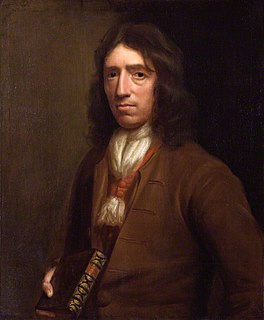
William Dampier was an English explorer, pirate, privateer, navigator, and naturalist who became the first Englishman to explore parts of what is today Australia, and the first person to circumnavigate the world three times. He has also been described as Australia's first natural historian, as well as one of the most important British explorers of the period between Sir Walter Raleigh and James Cook. His expeditions were the among first to identify and name a number of plants, animals, foods, and cooking techniques for an European audience; being among the first English writers to use words such as avocado, barbecue, and chopsticks. In describing the preparation of avocados, he was the first European to describe the making of guacamole, named the breadfruit plant, and made frequent documentation of the taste of numerous foods foreign to the European palate such as flamingo and manatee.
Dampier is a major industrial port in the Pilbara region in the northwest of Western Australia. It is located near the city of Karratha and Port Walcott.

The Kimberley is the northernmost of the nine regions of Western Australia. It is bordered on the west by the Indian Ocean, on the north by the Timor Sea, on the south by the Great Sandy and Tanami deserts in the region of the Pilbara, and on the east by the Northern Territory.
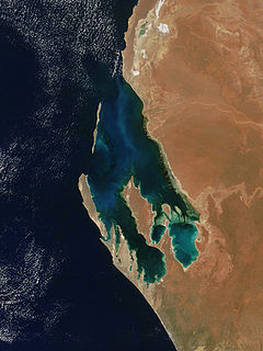
Shark Bay is a World Heritage Site in the Gascoyne region of Western Australia. The 23,000-square-kilometre (8,900 sq mi) area is located approximately 800 kilometres (500 mi) north of Perth, on the westernmost point of the Australian continent. UNESCO's official listing of Shark Bay as a World Heritage Site reads:
The Pilbara is a large, dry, thinly populated region in the north of Western Australia. It is known for its Aboriginal peoples; its ancient landscapes; the red earth; and its vast mineral deposits, in particular iron ore. It is also a global biodiversity hotspot for subterranean fauna.

Roebuck Bay is a bay on the coast of the Kimberley region of Western Australia. Its entrance is bounded in the north by the town of Broome, and in the south by Bush Point and Sandy Point. It is named after HMS Roebuck, the ship captained by William Dampier when he explored the coast of north-western Australia in 1699. The Broome Bird Observatory lies on the northern coast of the bay.

Gnaraloo is a working pastoral station and wilderness tourism business located in the Gnaraloo Bay in the Shire of Carnarvon, Western Australia. It is adjacent to the Ningaloo Marine Park and 150 km (93 mi) north of Carnarvon. It is famous for its coastline, wildlife and fishing and waves and wind.
The Western Australian Museum is a statutory authority within the Culture and the Arts Portfolio, established under the Museum Act 1969.

The Ningaloo Coast is a World Heritage Site located in the north west coastal region of Western Australia. The 705,015-hectare (1,742,130-acre) heritage-listed area is located approximately 1,200 kilometres (750 mi) north of Perth, along the East Indian Ocean. The distinctive Ningaloo Reef that fringes the Ningaloo Coast is 260 kilometres (160 mi) long and is Australia's largest fringing coral reef and the only large reef positioned very close to a landmass. The Muiron Islands and Cape Farquhar are within this coastal zone.

The Dampier Archipelago is a group of 42 islands near the town of Dampier in the Pilbara, Western Australia.
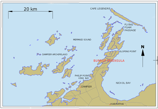
Murujuga, usually known as the Burrup Peninsula, is an island in the Dampier Archipelago, in the Pilbara region of Western Australia, containing the town of Dampier. Originally named Dampier Island after the English navigator William Dampier, it lies 3 kilometres (1.9 mi) off the Pilbara coast. In 1963 the island became an artificial peninsula when it was connected to the mainland by a causeway for a road and railway. In 1979 Dampier Peninsula was renamed Burrup Peninsula after Mt Burrup, the highest peak on the island, which had been named after Henry Burrup, a Union Bank clerk murdered in 1885 at Roebourne.
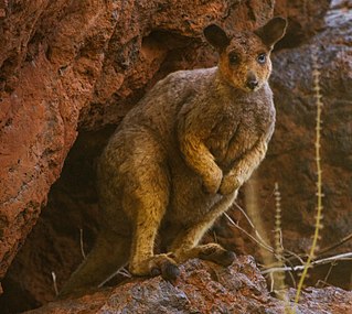
Rothschild's rock-wallaby – sometimes known as the Roebourne rock-wallaby, is a species of macropod found in Western Australia, in the Pilbara district and the Dampier Archipelago. It is not currently considered to be threatened, but is at risk from the red fox.

HMS Roebuck was a fifth-rate warship in the Royal Navy which, under the command of William Dampier, carried the first British scientific expedition to Australia in 1699. The wreck of the ship has since been located by a team from the Western Australian Maritime Museum at a site on the coast of Ascension Island where it foundered more than 300 years ago.
Depuch Island is a volcanic island located off the north-west coast of Western Australia's Pilbara region, near Port Hedland.
The Archipelago of the Recherche, known locally as the Bay of Isles, is a group of 105 islands, and over 1200 "obstacles to shipping", off the south coast of Western Australia. The islands stretch 230 km (140 mi) from east to west and to 50 km (31 mi) off-shore encompassing an area of approximately 4,000 square kilometres (1,544 sq mi). The western group is near Esperance and the eastern group at Israelite Bay. They are located in coastal waters, part of which is designated the Recherche Archipelago Nature Reserve.
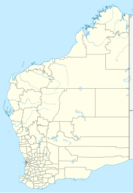
Western Australia has the longest coastline of any state or territory in Australia, at 10,194 km or 12,889 km. It is a significant portion of the coastline of Australia, which is 35,877 km.

The hawksbill sea turtle is a critically endangered sea turtle belonging to the family Cheloniidae. It is the only extant species in the genus Eretmochelys. The species has a worldwide distribution, with Atlantic and Indo-Pacific subspecies—E. i. imbricata and E. i. bissa, respectively.
Adele Island is an island located in the Indian Ocean approximately 104 kilometres (65 mi) North of Ardyaloon off the Kimberley coast in Western Australia.
Dolphin Island is an island situated in the Dampier Archipelago in the Pilbara region of Western Australia. Visitors are able to camp within 100 metres (328 ft) of the high water mark on all of the beaches on the island except for the south eastern side.
Thevenard Island is located approximately 22 kilometres (14 mi) off the coast of Onslow in the Pilbara region of Western Australia.