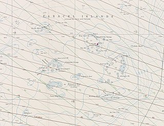
The Paracel Islands, also known as the Xisha Islands and the Hoàng Sa Archipelago, are a disputed archipelago in the South China Sea.
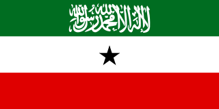
Somaliland, officially the Republic of Somaliland, is an unrecognised sovereign state in the Horn of Africa, recognised internationally as de jure part of Somalia. It is located in the southern coast of the Gulf of Aden and bordered by Djibouti to the northwest, Ethiopia to the south and west, and Somalia to the east. Its claimed territory has an area of 176,120 square kilometres (68,000 sq mi), with approximately 5.7 million residents as of 2021. The capital and largest city is Hargeisa. The government of Somaliland regards itself as the successor state to British Somaliland, which, as the briefly independent State of Somaliland, united from 1960 to 1991 with the Trust Territory of Somaliland to form the Somali Republic.

The Gulf of Aden is a deepwater gulf of the Indian Ocean between Yemen to the north, the Arabian Sea to the east, Djibouti to the west, and the Guardafui Channel, Socotra and Somalia to the south. In the northwest, it connects with the Red Sea through the Bab-el-Mandeb strait, and it connects with the Arabian Sea to the east. To the west, it narrows into the Gulf of Tadjoura in Djibouti. The Aden Ridge lies along the middle of the Gulf and is causing it to widen about 15mm per year.

Sool is an administrative region (gobol) in south/north western Somalia. It borders Togdheer to the west, Sanaag to the north, Ethiopia to the south and Nugal, Bari to the east. Its capital city is Las Anod. The region is disputed by the self-declared Republic of Somaliland and Puntland, a Federal Member State of Somalia. The region is partially controlled by both polities.

The Philippine Sea is a marginal sea of the Western Pacific Ocean east of the Philippine Archipelago and the largest sea in the world, occupying an estimated surface area of 5 million square kilometers. The Philippine Sea Plate forms the floor of the sea. Its western border is the first island chain to the west, comprising the Ryukyu Islands in the northwest and Taiwan in the west. Its southwestern border comprises the Philippine islands of Luzon, Catanduanes, Samar, Leyte, and Mindanao. Its northern border comprises the Japanese islands of Honshu, Shikoku and Kyūshū. Its eastern border is the second island chain to the east, comprising the Bonin Islands and Iwo Jima in the northeast, the Mariana Islands in the due east, and Halmahera, Palau, Yap and Ulithi in the southeast. Its southern border is Indonesia's Morotai Island.
The Sulu Sea is a body of water in the southwestern area of the Philippines, separated from the South China Sea in the northwest by Palawan and from the Celebes Sea in the southeast by the Sulu Archipelago. Borneo is found to the southwest and Visayas to the northeast.

East Africa, Eastern Africa, or East of Africa is the eastern subregion of the African continent. In the United Nations Statistics Division scheme of geographic regions, 10-11-(16*) territories make up Eastern Africa:

French Somaliland was a French colony in the Horn of Africa. It existed between 1884 and 1967, at which time it became the French Territory of the Afars and the Issas. The Republic of Djibouti is its legal successor state.

A pole of inaccessibility with respect to a geographical criterion of inaccessibility marks a location that is the most challenging to reach according to that criterion. Often it refers to the most distant point from the coastline, implying a maximum degree of continentality or oceanity. In these cases, a pole of inaccessibility can be defined as the center of the largest circle that can be drawn within an area of interest without encountering a coast. Where a coast is imprecisely defined, the pole will be similarly imprecise.

The Gulf of Naples, also called the Bay of Naples, is a roughly 15-kilometer-wide (9.3 mi) gulf located along the south-western coast of Italy. It opens to the west into the Mediterranean Sea. It is bordered on the north by the cities of Naples and Pozzuoli, on the east by Mount Vesuvius, and on the south by the Sorrento Peninsula and the main town of the peninsula, Sorrento. The Peninsula separates the Gulf of Naples from the Gulf of Salerno, which includes the Amalfi Coast.
Zeila, also known as Zaila or Zayla, is a historical port town in the western Awdal region of Somaliland.

Santo Niño, officially the Municipality of Santo Niño, is a 5th class municipality in the province of Samar, Philippines. According to the 2020 census, it has a population of 12,519 people.

The history of Somaliland, a country in the eastern Horn of Africa bordered by the Gulf of Aden, and the East African land mass, begins with human habitation tens of thousands of years ago. It includes the civilizations of Punt, the Ottomans, and colonial influences from Europe and the Middle East.

Seal Bay Conservation Park is a protected area located on the south coast of Kangaroo Island in the Australian state of South Australia. It is the home of the third largest Australian sea lion colony in Australia.
Awbare, officially known as Teferi Ber, is one of the woredas of the Fafan Zone in the Somali Region of Ethiopia. Awbare is bordered on the southwest by Jijiga, on the west by the Sitti Zone, on the east by Somaliland, and on the southeast by Kebri Beyah. Cities and towns in the Awbare district include Awbare, Awbube, Sheder, Lefe Isa, Derwernache, Gogti, Jaare and Heregel.

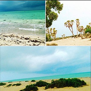
Heis is a historic coastal town located in the Sanaag region of Somaliland. The town was important for trade and communication with the Somali interior and was used to export frankincense to Arabia.

The Sa'ad ad-Din Islands, also Romanized as Sa'ad-ed-din and known as the Zeila Archipelago, are a group of islands off the northwestern coast of Somaliland. They are situated near the ancient city of Zeila.
Halul Island is one of the most important islands belonging to the State of Qatar. Lying about 90 km (56 mi) northeast of Doha, it serves as a storage area and loading terminal for oil from the surrounding offshore fields. One of the main bases for the Qatari Navy is located in Halul. The Coasts and Borders Security also have a base of operations on the island.
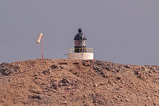
Aibat is the second-largest of the six islands of the Zeila Archipelago. It has a lighthouse. It is a low and sandy island, with bushes, that is around 1.75 miles in length and around 0.55 miles in breadth. It is mostly surrounded by a reef. The island has an area of 1.58 square kilometers and is located 1.9 kilometers north of Sacadin Island, the largest of the group, and about 21 kilometers east of the Djibouti border.


