A fall line is the area where an upland region and a coastal plain meet and is typically prominent where rivers cross it, with resulting rapids or waterfalls. The uplands are relatively hard crystalline basement rock, and the coastal plain is softer sedimentary rock. A fall line often will recede upstream as the river cuts out the uphill dense material, forming "c"-shaped waterfalls and exposing bedrock shoals. Because of these features, riverboats typically cannot travel any farther inland without portaging, unless locks are built. The rapid change in elevation of the water and resulting energy release make the fall line a good location for water mills, grist mills, and sawmills. Seeking a head of navigation with a ready supply of water power, people have long made settlements where rivers cross a fall line.
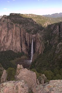
Basaseachic Falls on the Basaseachic River is the second-highest waterfall in Mexico, located in the Parque Nacional Basaseachic at Cañón Basaseachic in the Copper Canyon region of northwest Mexico, near Creel, Chihuahua. It is 246 meters (807 ft) tall, second in Mexico only to the Cascada de Piedra Volada.

The Montmorency Falls is a large waterfall on the Montmorency River in Quebec, Canada.

Oneonta Gorge is a scenic gorge located in the Columbia River Gorge area of the American state of Oregon. The U.S. Forest Service has designated it as a botanical area because of the unique aquatic and woodland plants that grow there. Exposed walls of 25-million-year-old basalt are home to a wide variety of ferns, mosses, hepatics, and lichens, many of which grow only in the Columbia River Gorge. Oneonta Gorge with its 50 species of wildflowers, flowering shrubs and trees has been described as "one of the true dramatic chasms in the state."

Yellowstone Falls consist of two major waterfalls on the Yellowstone River, within Yellowstone National Park, Wyoming, United States. As the Yellowstone river flows north from Yellowstone Lake, it leaves the Hayden Valley and plunges first over Upper Yellowstone Falls and then a quarter mile downstream over Lower Yellowstone Falls, at which point it then enters the Grand Canyon of the Yellowstone, which is up to 1,000 feet deep.

Uvas Canyon County Park is a 1,147-acre (464 ha) natural park located in upper Uvas Canyon on the eastern side of the Santa Cruz Mountains, west of Morgan Hill, California. The park has several small waterfalls, some of which flow perennially, that feed into tributaries confluent with Uvas Creek. The park is part of the Santa Clara County Parks System, and facilitates picnics, hiking and overnight camping. It is one of the few parks in the area that allows dogs in the campgrounds.

Sainte-Anne-de-Beaupré is a town in La Côte-de-Beaupré Regional County Municipality, Quebec, Canada, along the Saint Lawrence River, 35 kilometers (22 mi) north-east of Quebec City. The population was 2,803 according to the Canada 2006 Census. Major religious landmarks, the Basilica of Sainte-Anne-de-Beaupré and the Convent of the Redemptoristines, are located in the town. The basilica continues to attract pilgrims.

Nairn Falls Provincial Park is a provincial park in British Columbia, Canada located on the Green River adjacent to British Columbia Highway 99 and the Canadian National Railway line just south of Pemberton and less than twenty minutes north of the resort town of Whistler. The 170 hectare park was established in 1966, shortly after the highway's opening, to protect and enhance visitor access to Nairn Falls.
Piedra Volada Falls is a 453-meter tall plunge rainy season waterfall in the Barranca Candameña of the Sierra Madre Occidental range in Chihuahua, Mexico.

Silver Falls State Park is a state park in the U.S. state of Oregon, located near Silverton, about 20 miles (32 km) east-southeast of Salem. It is the largest state park in Oregon with an area of more than 9,000 acres (36 km2), and it includes more than 24 miles (39 km) of walking trails, 14 miles (23 km) of horse trails, and a 4-mile (6.4 km) bike path. Its 8.7-mile (14.0 km) Canyon Trail/Trail of Ten Falls runs along the banks of Silver Creek and by ten waterfalls, from which the park received its name. Four of the ten falls have an amphitheater-like surrounding that allows the trail to pass behind the flow of the falls. The Silver Falls State Park Concession Building Area and the Silver Creek Youth Camp-Silver Falls State Park are separately listed on the U.S. National Register of Historic Places.
Open from May to October, Canyon Sainte-Anne is a spectacular, steep-sided gorge, carved by the Sainte-Anne-du-Nord River, 6 km east of Beaupré, Quebec, Canada. The river drops over a 74 m (243 ft) waterfall within the canyon.

Ste-Anne-du-Nord River is a tributary of the northwest shore of the Saint Lawrence River where it flows at the height of Beaupré. This river flows in Capitale-Nationale, in the province of Quebec, Canada. The river passes through Canyon Sainte-Anne before joining the Saint Lawrence River at Beaupré.

Twister Falls is a prominent waterfall that is formed as Eagle Creek cascades 140 feet (43 m) into a narrow canyon and forms two streams that appear to "twist" around each other, hence the name "twister". The falls begin with a small sliding cascade that drops 5 feet (1.5 m) over a rocky slope into a pool, followed by some rapids. The next tier is the twisting tier, which plunges 50 feet (15 m). Before this point, a small portion of the stream splits off and makes a sheer plunge of approximately equal height down the canyon. Then, the waters combine and form a final drop of 80 feet (24 m).

McWay Creek is a 2.5-mile-long (4.0 km) coastal stream in Monterey County in the U.S. state of California. It flows steeply west and south from McWay Canyon, high in California's Central Coast Range, and spills into the Pacific Ocean at Waterfall Cove after flowing over scenic McWay Falls. Most of the creek and its watershed are contained within Julia Pfeiffer Burns State Park, 12 miles (19 km) south of Pfeiffer Big Sur State Park. The creek is named after Christopher McWay from New York, a pioneer who homesteaded the property.

Havasu Creek is a stream in the U.S. state of Arizona associated with the Havasupai people. It is a tributary to the Colorado River, which it enters in the Grand Canyon.
The Park of the Kabir Kouba Cliff and Waterfall is a public park in Quebec City, Quebec crossed by the Saint-Charles River. The rapids and falls of this section of the river are called Kabir Kouba the «river of a thousand bends» in the Montagnais language. An interpretive center and trails permit the observation of the Kabir Kouba waterfall that has a height of 28 metres. The trails also provide a view of the canyon which at its highest point measures 42 metres as well as a rich variety of flora, fauna and fossils dating over 455 million years old. The interpretive center also offers services such as Kabir Kouba by Lantern, A Day at Loretteville package as well as guided visits of the falls. A song by the singer Claire Pelletier, Kabir Kouba, evoques the many Huron legends that honour the river and the waterfall.
Proxy Falls, also known as Lower Proxy Falls, is a cascade and plunge waterfall from a collection of springs on the shoulder of North Sister, that plunges into a gaping canyon near McKenzie Pass in the Willamette National Forest, near Belknap Springs, Oregon. The waterfall is notable for its main drop of 226 feet (69 m) which makes it one of the highest plunge waterfalls in Oregon.

Twin Falls is a waterfall located in the Silver Falls State Park at the east end of the city of Salem, in Marion County, in the U.S. state of Oregon. It is located in the west foothills where Mount Hood National Forest meets with the Middle Santiam Wilderness. Several prominent waterfalls are located in the Park along Trail of Ten Falls: South Falls, Drake Falls, Lower South Falls, and Winter Falls—among others.
