Saipan International Airport

Last updated

Saipan International Airport

Francisco C. Ada Airport
Entrance to Saipan International Airport.JPG
Summary
Airport typePublic
Owner Commonwealth Ports Authority
Location Saipan, Northern Mariana Islands
Elevation  AMSL 215 ft / 66 m
Coordinates 15°07′08″N145°43′46″E / 15.11889°N 145.72944°E / 15.11889; 145.72944
Website cpa.gov.mp/spnapt.asp
Map
USA Northern Mariana Islands location map.svg
Airplane silhouette.svg
SPN
Runways
Direction LengthSurface
ftm
07/258,7002,652Asphalt
06/247,0012,134Asphalt
Statistics (2022)
Aircraft operations (year ending 1/31/2022)27,875
Based aircraft14
Saipan International Airport (far background), photographed from the top of Mount Tapochau. Saipan 2011 368.jpg
Saipan International Airport (far background), photographed from the top of Mount Tapochau.

Saipan International Airport( IATA : SPN, ICAO : PGSN, FAA LID : GSN), also known as Francisco C. Ada/Saipan International Airport, is a public airport located on Saipan Island in the United States Commonwealth of the Northern Mariana Islands. The airport is owned by Commonwealth Ports Authority. [1] Its airfield was previously known as Aslito (during the Japanese South Seas Mandate) and Isely Field (during the American World War II and later period).

Contents

This airport is assigned a three-letter location identifier of GSN by the Federal Aviation Administration, but the International Air Transport Association (IATA) airport code is SPN (the IATA assigned GSN to Mount Gunson Airport in Australia). [1] [2] [3] [4]

History

World War II

Saipan International Airport was a sugarcane field before the Imperial Japanese Navy Air Service (IJNAS) constructed a temporary landing field on the site in 1933. The landing field was used for training purposes and had two runways configured in an "L" pattern. In 1937, the Navy began upgrading the airfield for full military use, despite an international law ban on constructing military facilities within the South Seas Mandate. Following the attack against the United States in 1941, the field was named Aslito Field (アスリート飛行場), based on the indigenous Chamoru name for the area of its location, As Lito.

The IJNAS assigned two squadrons of Mitsubishi A6M5a-52 Zeros to the airfield in mid-June 1944. These squadrons took part in the occupation of the Mariana Islands during the Battle of the Philippine Sea later that month, being almost wiped out by the American forces during the battle.[ citation needed ]

The airfield was captured by the United States Army 27th Infantry Division on June 18, 1944, during the Battle of Saipan. During the battle, a Zero from Guam actually landed at Aslito Airfield, the pilot being unaware that the field was under American control. As it landed, the aircraft was fired at and damaged, crashing at the end of the runway. The pilot survived and the plane was captured. The field was renamed Isely Field after United States Navy Commander Robert H. Isely who was killed on June 13, 1944, while strafing the base. [5]

Once in American hands, Isely Field was quickly repaired and expanded by Seabees of the 3rd Battalion 20th Marines, to become Naval Advance Base Saipan. [6] with the first P 47s of the 19th fighter Squadron landing on the 20th. The airfield was assigned to Twentieth Air Force B-29 Superfortress operations. The XXI Bomber Command had overall responsibility of the B-29 operations out of the Marianas bases, and Isely Field was to be used by the 73rd Bombardment Wing (which consisted of the 497th, 498th, 499th, and 500th Bombardment Groups). [7]

On October 12, 1944, the first B-29 Joltin Josie The Pacific Pioneer piloted by Brigadier General Haywood S. Hansell commanding General of XXI Bomber Command and copiloted by Major Jack J Catton of the 873d Bombardment Squadron arrived at Isely Field. By November 22, over 100 B-29s were at Isely. The XXI Bomber Command was assigned the task of destroying the aircraft industry of Japan in a series of high-altitude, daylight precision attacks.[ citation needed ]

After several months of disappointing high level bombing attacks from Isely (and the other Twentieth Air Force airfields on Guam and Tinian), General Curtis LeMay, Commander of Twentieth Air Force issued a new directive that the high-altitude, daylight attacks be phased out and replaced by low-altitude, high-intensity incendiary raids at nighttime, being followed up with high explosive bombs once the targets were set ablaze. These nighttime attacks on Japan proved devastatingly effective, and the Superfortress missions from Isely Field led to massive destruction of industrial targets in Japan, with large industrial areas of Tokyo, Nagoya, and Osaka being repeatedly attacked by waves of American bombers flying from the Marianas until the war's end.[ citation needed ] In response to these attacks, most of the Japanese air attacks on the Mariana Islands between November 1944 and January 1945 targeted Isely Field.

The airfield and surviving World War II facilities were listed on the National Register of Historic Places in 1981 as the "Isely Field Historic District", and are a contributing element of the National Historic Landmark District Landing Beaches; Aslito/Isely Field; & Marpi Point, Saipan Island, which was designated in 1985.

Postwar

With the end of the war the wing's four bomb groups were all returned to the United States, with their B-29s either being flown to Clark Air Base in the Philippines for scrapping, or were flown to storage facilities in Texas or Arizona. The 73d Bomb Wing was reassigned to the United States in December 1945. The airfield was returned to civil control and it reverted to being called Aslito Field.[ citation needed ]

Terminal Airside, 2016 Saipan International airport (31037379131).jpg
Terminal Airside, 2016

Saipan International Airport commenced operation on July 25, 1976, taking over from the nearby Kobler Field. [8] Continental Micronesia (originally Air Micronesia) [9] initially had its main hub at Kobler Field and then Saipan Airport. As time passed, the airline's general traffic to and from Saipan had decreased due to the breakup of the Trust Territory of the Pacific Islands; because the territory was subdivided into smaller political units, fewer people needed to travel to Saipan, the former capital of the trust territory. [10] On July 15, 2008, the airline's Manila-Saipan flight, the final remaining Continental Micronesia directly operated flight, ended. [11]

Japanese tourists began visiting Saipan in large numbers during the 1970s. The airfield and terminal were significantly upgraded in 1975 to handle widebody aircraft.

Northwest Airlines historically served Saipan from Tokyo-Narita using McDonnell Douglas DC-10 and Boeing 747 aircraft, [12] while Japan Airlines (JAL) served Saipan from Narita and Osaka-Kansai using DC-10 and Boeing 767 aircraft respectively. [13] In 2005, JAL suspended its services from Japan to SPN; routes to Osaka and Nagoya were taken over by Northwest. [14] The airport was also renamed after former Lt. Gov. Francisco C. Ada that year. [15]

Delta Air Lines inherited Northwest's Saipan routes following its acquisition of Northwest in 2008. In 2018, Delta decided to withdraw from the Saipan market, simultaneously with terminating its service to Palau and one month after ending its service to Guam. Delta cited lower demand, as well as needs for additional Boeing 757 aircraft on domestic US flights, as reasons for the withdrawal. Northwest and Delta served Saipan for a total of 29 years. [16]

Skymark Airlines began flights to Saipan in 2019 using Boeing 737s from Narita. [17]

Accidents and incidents

Facilities and aircraft

Terminal, groundside Saipan International Airport Terminal Building1.JPG
Terminal, groundside

Saipan International Airport covers an area of 734 acres (297  ha ) which contains two paved runways: (7/25) measures 8,699 x 200 ft (2,651 x 61 m); (6/24) measures 7,001 x 100 ft (2,134 x 30 m). [1] [20]

For the 12-month period ending January 31, 2022, the airport had 27,875 aircraft operations, an average of 76 per day: 28% general aviation, 69% air taxi, 3% scheduled commercial and <1% military. [1]

Airlines and destinations

AirlinesDestinations
Asiana Airlines Charter: Seoul–Incheon [21]
Hong Kong Airlines Charter: Hong Kong [22]
Jeju Air Seasonal: Busan, [23]

Seoul–Incheon [24]

Star Marianas Air Rota, Tinian
T'way Air Seoul–Incheon [25]
United Airlines Guam, [26] Tokyo–Narita [27]

Statistics

Top destinations

Busiest domestic routes from SPN (September 2022 – August 2023) [28]
RankCityPassengersTop carriers
1 Guam 41,520United
2 Tinian, Northern Mariana Islands 26,890Star Marianas
3 Rota, Northern Mariana Islands 7,720Star Marianas

See also

Sources

Related Research Articles

<span class="mw-page-title-main">Continental Micronesia</span> Defunct airline of Guam and Micronesia (1968–2010)

Continental Micronesia, Inc. (CMI) was a Guamanian company which was a wholly owned subsidiary of Continental Airlines. It operated daily flights to Honolulu, Hawaii, as well as international services to Asia, Micronesia and Australia from its base of operations at Antonio B. Won Pat International Airport on Guam, a U.S. territory in the western Pacific Ocean. During its final years, the airline, a Delaware corporation, was headquartered in the old terminal building at Won Pat International Airport in Tamuning, Guam.

<span class="mw-page-title-main">Antonio B. Won Pat International Airport</span> Airport in Tamuning, Guam, United States

Antonio B. Won Pat International Airport, also known as Guam International Airport, is an airport located in Tamuning and Barrigada, three miles (4.8 km) east of the capital city of Hagåtña in the United States territory of Guam. The airport is a hub for Asia Pacific Airlines and for United Airlines, serving as the latter's Pacific Ocean hub. It is also the home of the former Naval Air Station Agana, and is the only international airport in the territory. The airport is named after Antonio Borja Won Pat, the first delegate from Guam to the United States House of Representatives, and is operated by the A.B. Won Pat International Airport Authority, Guam, an agency of the Government of Guam.

<span class="mw-page-title-main">Lubbock Preston Smith International Airport</span> Airport in Lubbock County, Texas

Lubbock Preston Smith International Airport is five miles north of Lubbock, in Lubbock County, Texas, United States. Originally Lubbock International Airport, it was renamed in 2004 for former Texas governor Preston E. Smith, an alumnus of Texas Tech University.

<span class="mw-page-title-main">Baton Rouge Metropolitan Airport</span> Airport in Baton Rouge, Louisiana

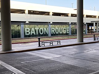
Baton Rouge Metropolitan Airport, also known as Ryan Field, is a public use airport located four miles (7 km) north of the central business district of Baton Rouge, a city in East Baton Rouge Parish, Louisiana, United States.

<span class="mw-page-title-main">Yuma International Airport</span> Airport in Arizona, United States

Yuma International Airport is a joint use airport with civilian and military flight activity operated in conjunction with the U.S. Marine Corps via the Marine Corps Air Station Yuma. The airfield is located 3.5 miles south of the central business district of Yuma, a city in Yuma County, Arizona, United States, and 150 miles east of San Diego International Airport. It is mostly used for military aviation, but is also served by one commercial airline and one aeromedical Medevac company as well as being used for general aviation activities.

<span class="mw-page-title-main">Juneau International Airport</span> International airport serving Juneau, Alaska, United States

Juneau International Airport is a city-owned, public-use airport and seaplane base located seven nautical miles northwest of the central business district of Juneau, a city and borough in the U.S. state of Alaska that has no direct road access to the outside world. The airport serves as a regional hub for all air travel, from bush carriers to major U.S. air carriers such as Alaska Airlines.

<span class="mw-page-title-main">Kinston Regional Jetport</span> Airport in Lenoir County, North Carolina

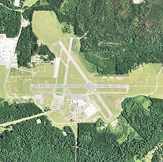
Kinston Regional Jetport, also known as Stallings Field, is a public airport located three miles (5 km) northwest of the central business district of Kinston, a city in Lenoir County, North Carolina. The airport has a single runway that is one of the longest in the southeastern United States. It is mostly used for general aviation.

<span class="mw-page-title-main">Pinal Airpark</span> Airport in Pinal County, Arizona

Pinal Airpark, also known as Pinal County Airpark, is a non-towered, county-owned, public-use airport located 8 miles northwest of the central business district of Marana, in Pinal County, Arizona, United States. Silverbell Army Heliport is co-located with Pinal Airpark. The heliport is a private-use military facility operated by the Arizona Army National Guard.

<span class="mw-page-title-main">Tinian International Airport</span> Airport in Tinian, Northern Mariana Islands, U.S.

Tinian International Airport, also known as West Tinian Airport, is a public airport located on Tinian Island in the United States Commonwealth of the Northern Mariana Islands. This airport is owned by Commonwealth Ports Authority.

Rota International Airport, also known as Benjamin Taisacan Manglona International Airport, is a public airport located on Rota Island in the United States Commonwealth of the Northern Mariana Islands (CNMI), near the village of Sinapalo. The airport is owned by the Commonwealth Ports Authority. During WWII the Japanese constructed a single runway which the U.S. bombed out of commission. After the Marines took control of the island 300 men from the 48th U.S.Naval Construction Battalion made the airfield operational during Sept-Oct 1945 and extended to 5,000 feet (1,500 m). The runway was then used as an emergency landing strip for Tinian and Saipan airfields. In modern times it used for short commuter flights to nearby Marianas Islands.

<span class="mw-page-title-main">Bucholz Army Airfield</span> Airport in Kwajalein

Bucholz Army Airfield is a United States Army airfield located on Kwajalein Atoll, Marshall Islands. Its position is ideal for refueling during trans-Pacific flights, and the airport is available to civilians through Air Marshall Islands and United Airlines.

<span class="mw-page-title-main">Chuuk International Airport</span> Airport in Weno

Chuuk International Airport is an airport located on Weno, the main island of the State of Chuuk in the Federated States of Micronesia.

<span class="mw-page-title-main">Naval Air Station Agana</span>

Naval Air Station Agana is a former United States Naval air station located on the island of Guam. It was opened by the Japanese Navy in 1943 and closed by the United States government in 1995. During and after its closure, it was operated alongside Antonio B. Won Pat International Airport.

<span class="mw-page-title-main">Landing Beaches; Aslito/Isely Field; & Marpi Point, Saipan Island</span> United States historic place

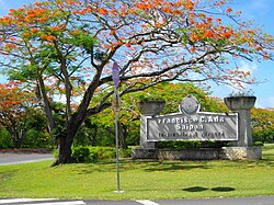
Landing Beaches; Aslito/Isely Field & Marpi Point, Saipan Island is a National Historic Landmark District consists of several discontiguous areas of the island of Saipan in the Northern Mariana Islands. The sites were designated for their association with the Japanese defense of Saipan during World War II, the 1944 Battle of Saipan in which United States forces captured the island, and the subsequent campaigns which used Saipan as a base. The district includes the landing beaches where the U.S. forces landed, the remnants of Japanese airfields Aslito and Marpi Point and Isely Field, the airfield built over much of Aslito from which B-29 bombers were used to bomb the Japanese home islands. The Marpi Point area includes Suicide Cliff and Banzai Cliff, two locations where significant numbers of Japanese military and civilians jumped to their deaths rather than surrender to advancing U.S. forces. The loss of Saipan was a major blow to the Japanese war effort, leading to the resignation of Prime Minister Hideki Tojo, The landmark designation was made in 1985.

<span class="mw-page-title-main">Esler Airfield</span> Airport in Rapides Parish, Louisiana

Esler Field, also known as Esler Regional Airport, is a military and public use airfield in Rapides Parish, Louisiana, United States, near the City of Pineville. It is located 10 nautical miles northeast of the central business district of Alexandria, Louisiana, The airfield is owned by the Louisiana Army National Guard and is the home of Army Aviation Support Facility #2 (AASF#2).

<span class="mw-page-title-main">Fletcher Field</span> Airport in Coahoma County

Fletcher Field is a public use airport in Coahoma County, Mississippi, United States. It is owned by the Coahoma County Airport Board and located seven nautical miles (13 km) northeast of the central business district of Clarksdale, Mississippi. This airport is included in the National Plan of Integrated Airport Systems for 2011–2015, which categorized it as a general aviation facility. There is no scheduled commercial airline service.

<span class="mw-page-title-main">Kobler Field</span> World War II airfield in the Mariana Islands

Kobler Field is a former a World War II airfield on Saipan in the Mariana Islands, part of Naval Advance Base Saipan. It was closed in 1977 and redeveloped as a residential housing area.

<span class="mw-page-title-main">Marpi Point Field</span>

Marpi Point Field or NAB Marpi Point is a former World War II airfield at the northern end of Saipan in the Northern Mariana Islands. The airfield was vacated by the United States in 1962; it is currently unused and overgrown.

<span class="mw-page-title-main">Star Marianas Air</span> Commuter airline

Star Marianas Air, Inc. is a U.S. commuter airline headquartered at Tinian International Airport in Tinian Municipality, Northern Mariana Islands. It operates scheduled and charter passenger service in the Commonwealth of the Northern Mariana Islands and Guam, both U.S. territories in the Pacific Ocean.

<span class="mw-page-title-main">Naval Advance Base Saipan</span> World War II base

Naval Base Saipan or Naval Advance Base Saipan or Naval Air Base Saipan was a United States Navy Naval base built during World War II to support Pacific Ocean theater of war and the many warships and troops fighting the war. The base was on the island of Saipan in the Northern Mariana Islands. The base was part of the Pacific island hopping campaign. The base construction started after the Battle of Saipan ended on July 9, 1944. US Naval Advance Base Saipan was constructed by the Seabees Naval Mobile Construction Battalions. The base was under the Commander Naval Forces Marianas. Saipan is 12 miles (19 km) long and 5 miles (8.0 km) wide. About 70% of the island was sugarcane cultivation at the start of the base construction. At the start of the Battle of Saipan, the island's population had about 30,000 Japanese troops and about 20,000 Japanese civilians. The city of Garapan was the administrative center for the Saipan governmental district.

References

  1. 1 2 3 4 5 FAA Airport Form 5010 for GSN PDF , retrieved 2021-06-09
  2. "Airline and Airport Code Search". International Air Transport Association (IATA). Retrieved November 14, 2016.
  3. "Saipan International (IATA: SPN, ICAO: PGSN, FAA: GSN)". Great Circle Mapper. Retrieved November 14, 2016.
  4. "Mount Gunson Airport (IATA: GSN, ICAO: YMGN)". Aviation Safety Network . Retrieved November 14, 2016.
  5. Hammel, Eric (January 22, 2010). Air War Pacific: Chronology: America's Air War Against Japan in East Asia and the Pacific, 1941–1945. Pacifica, California: Pacifica Military History. p. 383. ISBN   978-1890988104.
  6. Saipan, Building the Navy's Bases in World War II, History of the Bureau of Yards and Docks and the Civil Engineer Corps, 1940-1946, Volume II, UNITED STATES GOVERNMENT PRINTING OFFICE, WASHINGTON, 1947, p.340
  7. Peacock Air International August 1989, p. 87.
  8. "History". Commonwealth Ports Authority. Retrieved May 28, 2013.
  9. "GAO-10-778T Issues Raised by the Proposed Merger of United and Continental Airlines." Government Accountability Office . Page 4. Retrieved on October 7, 2010.
  10. Vergara, Jaime R. "Celebrating the de-inauguration of CO 895." (Opinion page) Saipan Tribune . Monday July 21, 2008. Retrieved on October 13, 2010.
  11. Deposa, Moneth G. Continental shuts down Saipan office." Marianas Variety News & Views . July 17, 2008. Retrieved on February 25, 2009.
  12. "Northwest's B747 flies to Saipan". Saipan Tribune. October 4, 1999. Retrieved July 26, 2018.
  13. "Japan Airlines to close Northern Marianas office at month's end". Radio New Zealand. October 25, 2005. Retrieved July 26, 2018.
  14. "Saipan Tribune". Archived from the original on March 8, 2012. Retrieved June 25, 2010.
  15. "Saipan Tribune". Archived from the original on March 8, 2012. Retrieved March 21, 2010.
  16. Cabrera, Bea (February 8, 2018). "Delta to end flights to Saipan, Palau". Saipan Tribune. Retrieved July 26, 2018.
  17. "Skymark to offer Tokyo service to Saipan and Palau". Nikkei Asian Review. June 20, 2018. Retrieved July 26, 2018.
  18. Administrator. "BREAKING NEWS: Plane crash at Saipan International Airport". Archived from the original on January 29, 2013. Retrieved June 7, 2015.
  19. Gaynor Dumat-ol Daleno, "1 killed in Saipan plane crash," Pacific Daily News, November 20, 2012, http://www.guampdn.com/article/20121120/NEWS01/211200301/1-killed-Saipan-plane-crash?odyssey=tab%7Ctopnews%7Ctext%7CFrontpage
  20. "GSN airport data at skyvector.com". skyvector.com. Retrieved September 28, 2022.
  21. "Asiana Airlines halts regular flights to Saipan". RNZ. March 6, 2024.
  22. "Hong Kong Airlines Resumes Saipan Service in 2Q24". Aeroroutes. Retrieved March 5, 2024.
  23. "Jeju Air W18 Saipan service changes as of 27NOV18".
  24. "Jeju Air Saipan service changes from late-Nov 2018".
  25. "T'Way plans Saipan launch in Dec 2016". routesonline. Retrieved October 26, 2016.
  26. "United to change flights between Guam and Saipan June 1". April 16, 2018.
  27. "UNITED RESUMES SAIPAN – TOKYO SERVICE FROM SEP 2022". Aeroroutes. Retrieved June 27, 2022.
  28. "RITA | BTS | Transtats". Transtats.bts.gov. May 10, 2017. Retrieved May 10, 2017.