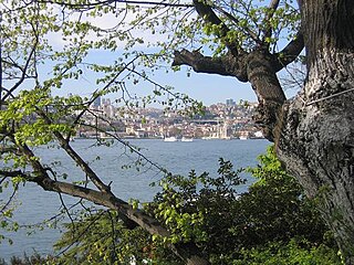
The Bosporus or Bosphorus is a narrow, natural strait and an internationally significant waterway located in northwestern Turkey. It forms part of the continental boundary between Europe and Asia, and separates Asian Turkey from European Turkey. The world's narrowest strait used for international navigation, the Bosporus connects the Black Sea with the Sea of Marmara, and, by extension via the Dardanelles, the Aegean and Mediterranean seas.
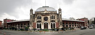
Sirkeci railway station, listed on maps as Istanbul railway station, is a railway terminal in Istanbul. The terminal is located on the tip of Istanbul's historic peninsula right next to the Golden Horn and just northwest of Gülhane Park and the Topkapı Palace. Sirkeci Terminal, along with Haydarpaşa Terminal on the other side of the Bosphorus, are Istanbul's two intercity and commuter railway terminals. Built in 1890 by the Oriental Railway as the eastern terminus of the world-famous Orient Express, Sirkeci Terminal has become a symbol of the city. As of 19 March 2013 service to the station had been indefinitely suspended due to the rehabilitation of the existing line between Kazlıçeşme and Halkalı for the new Marmaray commuter rail line. On 29 October 2013, a new underground station opened to the public and is currently serviced by Marmaray trains travelling across the Bosphorus. Sirkeci Terminal has a total of 4 platforms with 7 tracks. Formerly, commuter trains to Halkalı would depart from tracks 2, 3 and 4 while regional trains to Kapıkule, Edirne and Uzunköprü along with international trains to Bucharest, Sofia and Belgrade would depart from tracks 1 and 5.
Beylerbeyi is a neighborhood in the Üsküdar municipality of Istanbul, Turkey. It is located on the Asian shore of the Bosporus, to the north of the Bosphorus Bridge. It is bordered on the northeast by the neighborhood of Çengelköy, on the east by Kirazlıtepe, on the southeast by Küplüce, on the south by Burhaniye, on the southwest by Kuzguncuk, and on the northwest by the Bosporus. Directly across the Bosporus is the Ortaköy neighborhood of Istanbul's Beşiktaş municipality.

Capitol Shopping Center, opened 1993 in Altunizade neighborhood of Üsküdar, is the first modern big shopping mall on the Asian part of Istanbul, Turkey.
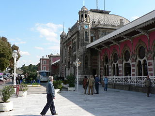
Sirkeci is a quarter in the Eminönü neighborhood of the Fatih district of the city of Istanbul, Turkey. The neighborhood borders to the North the mouth of the Golden Horn, to the West the neighborhood of Bahçekapı, to the East the Topkapi Palace area, and to the South the Cağaloğlu neighborhood. Sirkeci hosts Sirkeci Station, the Southeastern long distance passenger train terminus in Europe for the Orient Express.
Kuzguncuk is a neighborhood in the Üsküdar district on the Asian side of the Bosphorus in Istanbul, Turkey. The neighborhood is centered on a valley opening to the Bosphorus and is somewhat isolated from the main part of the city, being surrounded by nature preserves, cemeteries, and a military installation. It is a quiet neighborhood with streets lined with antique wooden houses.

Çengelköy is a neighborhood in the Üsküdar district on the Asian shore of the Bosphorus, in Istanbul, Turkey, between the neighborhoods of Beylerbeyi and Kuleli. It is mainly a residential district. Many mansions were built there in the Ottoman period.
Fethi Paşa Korusu is a large park in Istanbul, Turkey, on the hillside coming right down to the Bosphorus shore in the area called Paşalimanı. It is located between Kuzguncuk and Sultantepe neighborhoods in district Üsküdar on the Asian side of Istanbul. It is named after Ottoman governor, ambassador and minister Fethi Ahmet Pasha. After long years of neglect, it has been recently renovated and opened to public for recreation. It has a scenic view of Bosphorus Bridge and the European side of Istanbul.

The Hatice Sultan Palace, a historical yalı located at Bosporus in Ortaköy neighborhood of Istanbul, Turkey and named after its original owner Hatice Sultan, is used today as a water sports club's building.

Sultantepe is a neighborhood in the municipality of Üsküdar on the Asian side of Istanbul, Turkey. The name Sultantepe means "sultan hill."
İcadiye is a neighborhood in the Üsküdar municipality on the Asian side of Istanbul, Turkey. It is centered on İcadiye Hill and is bordered on the north by Kuzguncuk, on the east by Altunizade, on the south by Selami Ali, and on the west by Sultantepe. It is mostly a residential neighborhood, with a few historic houses and buildings.

Hasköy is a quarter (semt) on the northern bank of the Golden Horn in Beyoğlu, Istanbul, Turkey. It includes the officially defined neighborhoods (mahalleler) of Keçeci Piri, Piri Paşa, and Halıcıoğlu, and parts of Camiikebir and Sütlüce.

Selamsız is a quarter in Üsküdar district on the Asian side of Istanbul, Turkey. It corresponds more or less to the current officially recognized neighborhoods of Selamiali and Muratreis. These neighborhoods are bounded on the north by Sultantepe, on the north and northeast by İcadiye, on the east by Altunizade, on the south by Valide-i Atik, and on the west by Mimarsinan.

TVF 50th Anniversary Sport Hall, is a volleyball and indoor beach volley hall situated within the Burhan Felek Sports Complex at Altunizade neighborhood of Üsküdar district in Istanbul, Turkey. It was re-opened on October 11, 2008. It is owned by the Municipality of Kadıköy District and operated by the Directorate of Youth and Sport of Istanbul Province.
Burhaniye is a neighborhood in the Üsküdar municipality on the Asian side of Istanbul, Turkey. Burhaniye is mostly a residential neighborhood, with few historic houses and buildings. It is bordered on the north by Beylerbeyi and Küplüce, on the east by Kısıklı, on the south by Küçükçamlıca, and on the west by Altunizade and Kuzguncuk. The Otoyol 1 highway runs along the western border of the neighborhood.
Baltalimanı is a neighborhood at a bay of the European coast of Bosporus, in the Sarıyer district of Istanbul, Turkey. The name means "axe port" in Turkish.
Private Armenian School of Pangaltı is a private Armenian community school in Pangaltı quarter in Şişli district, Istanbul, Turkey.
Üsküdar is an underground station and the western terminus of the M5 line of the Istanbul Metro in Üsküdar. It is located beneath Üsküdar Square, near the Bosporus in the Mimar Sinan neighborhood. Connection to trans-Bosporus Marmaray commuter rail service is available from Üsküdar station as well as IETT city buses and municipal ferries from Üsküdar pier.
The Üsküdar Ferry Terminal, also known as the Üsküdar Pier, is a ferry terminal in Üsküdar, Istanbul, located along Paşa Limanı Avenue on the Bosporus strait. It is used by Municipal Şehir Hatları ferries as well as private Dentur ferries. Şehir Hatları ferries operate to several piers along the Bosporus and Golden Horn, while Dentur operates frequent ferry service to Kabataş and Beşiktaş.