San Fernando, Cebu

Last updated
San Fernando
Municipality of San Fernando
San Fernando Cebu.JPG
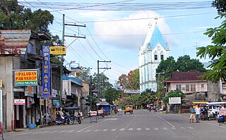
San Fernando Municipal Hall
Flag of San Fernando, Cebu.png
San Fernando Cebu seal.jpg
Anthem: San Fernando,Cebu hymn
Ph locator cebu san fernando.png
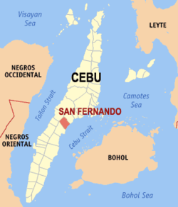
Map of Cebu with San Fernando highlighted
OpenStreetMap
San Fernando, Cebu
Philippines location map (square).svg
Red pog.svg
San Fernando
Location within the Philippines
Coordinates: 10°10′N123°42′E / 10.17°N 123.7°E / 10.17; 123.7
Country Philippines
Region Central Visayas
Province Cebu
District 1st district
Founded 1858
Barangays 21 (see Barangays)
Government
[1]
  Type Sangguniang Bayan
   Mayor Mytha Ann B. Canoy (PPP)
   Vice Mayor Ricci Regen G. Reluya (NP)
   Representative Rhea Mae A. Gullas
   Municipal Council
Members
   Electorate 50,018 voters (2022)
Area
[2]
  Total69.39 km2 (26.79 sq mi)
Elevation
85 m (279 ft)
Highest elevation
401 m (1,316 ft)
Lowest elevation
0 m (0 ft)
Population
 (2020 census) [3]
  Total72,224
  Density1,000/km2 (2,700/sq mi)
   Households
16,555
Economy
   Income class 2nd municipal income class
   Poverty incidence
15.00
% (2018) [4]
   Revenue 244.9 million (2020)
   Assets 725.5 million (2020)
   Expenditure 257.5 million (2020)
   Liabilities 101.9 million (2020)
Service provider
  Electricity Visayan Electric Company (VECO)
Time zone UTC+8 (PST)
ZIP code
6018
PSGC
IDD : area code +63(0)32
Native languages Cebuano
Tagalog

San Fernando, officially the Municipality of San Fernando (Cebuano : Lungsod sa San Fernando; Tagalog : Bayan ng San Fernando), is a second-class municipality in the province of Cebu, Philippines. According to the 2020 census, it has a population of 72,224 people. [3]

Contents

San Fernando is bordered to the north by the City of Naga, to the west is the town of Pinamungajan, to the east is the Cebu Strait, and to the south is the city of Carcar. It is 29 kilometres (18 mi) from Cebu City.

San Fernando lies within Metro Cebu. [5]

Geography

Barangays

San Fernando is politically subdivided into 21 barangays. Each barangay consists of puroks and some have sitios.

PSGC Barangay Population ±% p.a.
2020 [3] 2010 [6]
072241002 Balud 5.7% 4,135 3,525 1.61%
072241003 Balungag 2.9% 2,116 1,855 1.32%
072241005 Basak 1.4% 1,017 1,009 0.08%
072241007 Bugho 1.8% 1,317 1,367 −0.37%
072241008 Cabatbatan 2.7% 1,933 1,875 0.31%
072241009 Green Hills 3.5% 2,508 2,700 −0.73%
072241024 Ilaya 2.7% 1,975 1,918 0.29%
072241010 Lantawan 2.8% 2,054 1,789 1.39%
072241011 Liburon 1.4% 995 1,009 −0.14%
072241012 Magsico 3.0% 2,188 2,188Steady2.svg 0.00%
072241014 Panadtaran 7.5% 5,400 4,971 0.83%
072241015 Pitalo 11.0% 7,962 7,311 0.86%
072241013 Poblacion North 6.2% 4,444 4,205 0.55%
072241018 Poblacion South 11.5% 8,294 7,352 1.21%
072241016 San Isidro 5.7% 4,128 3,691 1.13%
072241017 Sangat 8.2% 5,910 5,597 0.55%
072241019 Tabionan 3.0% 2,147 1,873 1.37%
072241020 Tananas 2.4% 1,706 1,345 2.41%
072241021 Tinubdan 3.1% 2,215 1,994 1.06%
072241022 Tonggo 2.9% 2,110 1,936 0.86%
072241023 Tubod 2.4% 1,726 1,460 1.69%
Total72,22460,9701.71%

Climate

Climate data for San Fernando, Cebu
MonthJanFebMarAprMayJunJulAugSepOctNovDecYear
Mean daily maximum °C (°F)28
(82)
29
(84)
30
(86)
31
(88)
31
(88)
30
(86)
30
(86)
30
(86)
30
(86)
29
(84)
29
(84)
28
(82)
30
(85)
Mean daily minimum °C (°F)23
(73)
23
(73)
23
(73)
24
(75)
25
(77)
25
(77)
25
(77)
25
(77)
25
(77)
25
(77)
24
(75)
23
(73)
24
(75)
Average precipitation mm (inches)70
(2.8)
49
(1.9)
62
(2.4)
78
(3.1)
138
(5.4)
201
(7.9)
192
(7.6)
185
(7.3)
192
(7.6)
205
(8.1)
156
(6.1)
111
(4.4)
1,639
(64.6)
Average rainy days13.410.613.114.524.227.928.427.727.127.422.515.9252.7
Source: Meteoblue [7]

Demographics

Population census of San Fernando
YearPop.±% p.a.
1903 15,451    
1918 20,029+1.75%
1939 17,562−0.62%
1948 16,132−0.94%
1960 19,061+1.40%
1970 24,073+2.36%
1975 25,877+1.46%
1980 28,324+1.82%
1990 35,051+2.15%
1995 38,700+1.87%
2000 48,235+4.83%
2007 54,932+1.81%
2010 60,970+3.87%
2015 66,280+1.60%
2020 72,224+1.70%
Source: Philippine Statistics Authority [8] [6] [9] [10]

Economy

Notable personalities

Related Research Articles

<span class="mw-page-title-main">Catmon</span> Municipality in Cebu, Philippines

Catmon, officially the Municipality of Catmon, is a 4th class municipality in the province of Cebu, Philippines. According to the 2020 census, it has a population of 33,745 people.

<span class="mw-page-title-main">Alcantara, Cebu</span> Municipality in Cebu, Philippines

Alcantara, officially the Municipality of Alcantara, is a 5th class municipality in the province of Cebu, Philippines. According to the 2020 census, it has a population of 16,910 people.

<span class="mw-page-title-main">Asturias, Cebu</span> Municipality in Cebu, Philippines

Asturias, officially the Municipality of Asturias, is a 3rd class municipality in the province of Cebu, Philippines. According to the 2020 census, it has a population of 55,397 people.

<span class="mw-page-title-main">Balamban</span> Municipality in Cebu, Philippines

Balamban, officially the Municipality of Balamban, is a 1st class municipality in the province of Cebu, Philippines. According to the 2020 census, it has a population of 95,136 people.

<span class="mw-page-title-main">Carmen, Cebu</span> Municipality in Cebu, Philippines

Carmen, officially the Municipality of Carmen, is a 3rd class municipality in the province of Cebu, Philippines. According to the 2020 census, it has a population of 57,897 people.

<span class="mw-page-title-main">Ginatilan</span> Municipality in Cebu, Philippines

Ginatilan, officially the Municipality of Ginatilan, is a 5th class municipality in the province of Cebu, Philippines. According to the 2020 census, it has a population of 16,906 people.

<span class="mw-page-title-main">Malabuyoc</span> Municipality in Cebu, Philippines

Malabuyoc, officially the Municipality of Malabuyoc, is a 5th class municipality in the province of Cebu, Philippines. According to the 2020 census, it has a population of 19,770 people.

<span class="mw-page-title-main">Medellin, Cebu</span> Municipality in Cebu, Philippines

Medellin, officially the Municipality of Medellin, is a 2nd class municipality in the province of Cebu, Philippines. According to the 2020 census, it has a population of 59,605 people.

<span class="mw-page-title-main">Pilar, Cebu</span> Municipality in Cebu, Philippines

Pilar, officially the Municipality of Pilar, is a 5th class municipality in the province of Cebu, Philippines. According to the 2020 census, it has a population of 12,506 people.

<span class="mw-page-title-main">Pinamungajan</span> Municipality in Cebu, Philippines

Pinamungajan, officially the Municipality of Pinamungajan, is a 2nd class municipality in the province of Cebu, Philippines. According to the 2020 census, it has a population of 75,131 people.

<span class="mw-page-title-main">Poro, Cebu</span> Municipality in Cebu, Philippines

Poro, officially the Municipality of Poro, is a 4th class municipality in the province of Cebu, Philippines. According to the 2020 census, it has a population of 26,232 people.

<span class="mw-page-title-main">Ronda, Cebu</span> Municipality in Cebu, Philippines

Ronda, officially the Municipality of Ronda, is a 5th class municipality in the province of Cebu, Philippines. According to the 2020 census, it has a population of 21,005 people.

<span class="mw-page-title-main">San Francisco, Cebu</span> Municipality in Cebu, Philippines

santa Rosa Laguna citi

<span class="mw-page-title-main">Santa Fe, Cebu</span> Municipality in Cebu, Philippines

Santa Fe, officially the Municipality of Santa Fe, is a 4th class municipality in the province of Cebu, Philippines. According to the 2020 census, it has a population of 34,471 people.

<span class="mw-page-title-main">Tabogon</span> Municipality in Cebu, Philippines

Tabogon, officially the Municipality of Tabogon, is a 3rd class municipality in the province of Cebu, Philippines. According to the 2020 census, it has a population of 41,432 people.

<span class="mw-page-title-main">Tabuelan</span> Municipality in Cebu, Philippines

Tabuelan, officially the Municipality of Tabuelan, is a 4th class municipality in the province of Cebu, Philippines. According to the 2020 census, it has a population of 28,907 people.

<span class="mw-page-title-main">Tudela, Cebu</span> Municipality in Cebu, Philippines

Tudela, officially the Municipality of Tudela, is a 5th class municipality in the province of Cebu, Philippines. According to the 2020 census, it has a population of 11,304 people.

<span class="mw-page-title-main">Calape</span> Municipality in Bohol, Philippines

Calape, officially the Municipality of Calape, is a 3rd class municipality in the province of Bohol, Philippines. According to the 2020 census, it has a population of 33,079 people.

<span class="mw-page-title-main">San Isidro, Bohol</span> Municipality in Bohol, Philippines

San Isidro, officially the Municipality of San Isidro, is a 5th class municipality in the province of Bohol, Philippines. According to the 2020 census, it has a population of 9,909 people.

<span class="mw-page-title-main">Carcar</span> Component city in Cebu, Philippines

Carcar, officially the City of Carcar, is a 5th class component city in the province of Cebu, Philippines. According to the 2020 census, it has a population of 136,453 people.

References

  1. Municipality of San Fernando | (DILG)
  2. "2015 Census of Population, Report No. 3 – Population, Land Area, and Population Density" (PDF). Philippine Statistics Authority. Quezon City, Philippines. August 2016. ISSN   0117-1453. Archived (PDF) from the original on May 25, 2021. Retrieved July 16, 2021.
  3. 1 2 3 Census of Population (2020). "Region VII (Central Visayas)". Total Population by Province, City, Municipality and Barangay. Philippine Statistics Authority . Retrieved 8 July 2021.
  4. "PSA Releases the 2018 Municipal and City Level Poverty Estimates". Philippine Statistics Authority. 15 December 2021. Retrieved 22 January 2022.
  5. Sun Star Cebu 2005.
  6. 1 2 Census of Population and Housing (2010). "Region VII (Central Visayas)" (PDF). Total Population by Province, City, Municipality and Barangay. National Statistics Office . Retrieved 29 June 2016.
  7. "San Fernando: Average Temperatures and Rainfall". Meteoblue. Retrieved 10 May 2020.
  8. Census of Population (2015). "Region VII (Central Visayas)". Total Population by Province, City, Municipality and Barangay. Philippine Statistics Authority . Retrieved 20 June 2016.
  9. Censuses of Population (1903–2007). "Region VII (Central Visayas)". Table 1. Population Enumerated in Various Censuses by Province/Highly Urbanized City: 1903 to 2007. National Statistics Office.{{cite encyclopedia}}: CS1 maint: numeric names: authors list (link)
  10. "Province of Cebu". Municipality Population Data. Local Water Utilities Administration Research Division. Retrieved 17 December 2016.
  11. "Poverty incidence (PI):". Philippine Statistics Authority. Retrieved December 28, 2020.
  12. "Estimation of Local Poverty in the Philippines" (PDF). Philippine Statistics Authority. 29 November 2005.
  13. "2003 City and Municipal Level Poverty Estimates" (PDF). Philippine Statistics Authority. 23 March 2009.
  14. "City and Municipal Level Poverty Estimates; 2006 and 2009" (PDF). Philippine Statistics Authority. 3 August 2012.
  15. "2012 Municipal and City Level Poverty Estimates" (PDF). Philippine Statistics Authority. 31 May 2016.
  16. "Municipal and City Level Small Area Poverty Estimates; 2009, 2012 and 2015". Philippine Statistics Authority. 10 July 2019.
  17. "PSA Releases the 2018 Municipal and City Level Poverty Estimates". Philippine Statistics Authority. 15 December 2021. Retrieved 22 January 2022.

Sources