Sandown Bay

Last updated

Sandown Bay
Sandown Bay.jpg
Sandown Bay at dusk; looking south-west from Culver Down
Isle of Wight UK location map.svg
Red pog.svg
Sandown Bay
Location within the Isle of Wight
Civil parish
Ceremonial county
Region
Country England
Sovereign state United Kingdom
UK Parliament
List of places
UK
England
Isle of Wight
50°38′N1°08′W / 50.633°N 1.133°W / 50.633; -1.133

Sandown Bay is a broad open bay which stretches for much of the length of the Isle of Wight's southeastern coast. It extends 8+12 miles (13.7 km) from Culver Down, near Yaverland in the northeast of the Island, to just south of Shanklin, near the village of Luccombe in the southwest. [1] At Luccombe, the bay is separated from The Undercliff by a large headland from which Upper Ventnor sits atop. The towns of Shanklin, Lake and Sandown are on the bay's coast, while Luccombe and Upper Ventnor feature panoramic views across both Sandown Bay to the East and the Undercliff to the southwest. Due to the bay being relatively sheltered from offshore winds it is often used as temporary anchorage point for boats, [2] including large cargo ships, before continuing east towards Continental Europe, or north towards The Solent.

Contents

History

The white cliffs of Culver Down painted by A. Heaton Cooper
.mw-parser-output .citation{word-wrap:break-word}.mw-parser-output .citation:target{background-color:rgba(0,127,255,0.133)}
^ Beautiful Britain - The Isle of Wight - by G.E. Mitton - 2 SANDOWN BAY.jpg
The white cliffs of Culver Down painted by A. Heaton Cooper ^

In the past, the bay had significant military importance as the wide beach offered a good landing-point for an armed invasion of the Island. To protect against a French or Spanish invasion, Henry VIII built Sandown Castle in the centre of the bay as part of his chain of coastal defences to protect the South-Coast of England. However, the castle was still under construction during the French invasion of the Isle of Wight of 1545 when it was overwhelmed. [2] This castle fell into disrepair due to coastal erosion and was demolished in 1631, though the remains of the foundations of the castle are still visible along the shore at low tide. [3] Sandown Fort, also known as the Diamond Fort after its arrow-headed bastions, this was built using the remains of the old castle further up the coast. [2]

As a result of its sandy beach and good weather, Sandown and Shanklin grew rapidly in the Victorian era as tourists from across both the Island and the country came to enjoy the seaside thanks to new the transportation connections of the railway and paddle steamers. [4] This transformed a relatively sparsely populated area into a series of bustling seaside resorts. New developments included a long promenade, many large seafront hotels and the 875 foot Sandown Pier (originally 360 ft when opened in 1879). [5] A lot of Victorian-influenced architecture can still be seen throughout the bay.

Geography

Sandown Bay at Lake, looking north-east towards Sandown, with Yaverland and Culver Down in the distance Sandown Bay, Isle of Wight, UK (2).jpg
Sandown Bay at Lake, looking north-east towards Sandown, with Yaverland and Culver Down in the distance

Sandown Bay is an excellent example of a concordant coastline and has well-developed sandy beaches stretching all the way from Shanklin to Culver Down due to Longshore drift. [6] The bay has over 5 miles of unbroken sandy beach, making it one of the longest beaches in the British Isles. [7] The area has weak sandstone cliffs which vary from 30 to 130 feet (10 to 40 m), these have suffered from erosion and instability in the past. The risk of cliff-failures affecting populated tourist areas led the Isle of Wight Council to commission a report and an extensive structural stabilisation programme in 1988. [8]

The bay is best viewed from Culver Down to the north. The Isle of Wight Coastal Path follows the whole bay-line either along the cliff top to the south of Sandown or the concrete seawall north of Sandown. [9]

The bay itself has a seabed consisting of a mixture of sand, shells and gravel with shallow waters out till about one-quarter of a nautical mile (1,500 ft; 460 m). [2] The total area of the bay is 5 square miles (13 km2). [7]

Economy and tourism

The economy of the bay is dominated by retail and hospitality sectors due to a large amount of tourism it receives, an estimate of 500,000 visitors annually. However, the average earnings of people living around the bay are approximately 10% below the national average. [7] A local action-plan, the Bay Area Action Plan, has been set up in 2016 for the development of the bay for the next 15 years. It plans to get local and national funding with the aim to improve public spaces and increase the level of tourism. [7] The bay has a combined total of 21,374 inhabitants. [10]

Maritime incidents

The outer bay is used as a sheltered anchorage. Ships requiring salvage have sometimes been towed there, such as the tanker Tarpenbeck in 1979. The wreck of a salvage tug (the Harry Sharman) which assisted the stricken tanker Pacific Glory in 1970, [11] was visible for some decades at low tide below Culver Cliffs.

Notes

  • ^ From the Beautiful Britain series, The Isle of Wight, by G. E. Mitton, 1911. Caption: The white cliffs of Culver Down are the eastward end of the rib of chalk which has its other extremity at the Needles.

Related Research Articles

<span class="mw-page-title-main">Isle of Wight</span> County and island of England

The Isle of Wight is an island, English county and unitary authority in the English Channel, 2 to 5 miles off the coast of Hampshire, across the Solent. It is the largest and second-most populous island in England. Referred to as "The Island" by residents, the Isle of Wight has resorts that have been popular holiday destinations since Victorian times. It is known for its mild climate, coastal scenery, and verdant landscape of fields, downland, and chines. The island is historically part of Hampshire. The island is designated a UNESCO Biosphere Reserve.

<span class="mw-page-title-main">Sandown</span> Human settlement in England

Sandown is a seaside resort town and civil parish on the south-east coast of the Isle of Wight, United Kingdom with the resort of Shanklin to the south and the settlement of Lake in between. Sandown has a population of 11,654 according to the 2021 Census and together with Shanklin and Lake forms a built-up area of around 25,000 inhabitants.

<span class="mw-page-title-main">Ventnor</span> Human settlement in England

Ventnor is a seaside resort town and civil parish established in the Victorian era on the southeast coast of the Isle of Wight, England, eleven miles (18 km) from Newport. It is situated south of St Boniface Down, and built on steep slopes leading down to the sea. The higher part is referred to as Upper Ventnor ; the lower part, where most amenities are located, is known as Ventnor. Ventnor is sometimes taken to include the nearby and older settlements of St Lawrence and Bonchurch, which are covered by its town council. The population is 5,567 according to the 2021 Census

<span class="mw-page-title-main">Shanklin</span> Human settlement in England

Shanklin is a seaside resort town and civil parish on the Isle of Wight, England, located on Sandown Bay. Shanklin is the southernmost of three settlements which occupy the bay, and is close to Lake Sandown. The sandy beach, its Old Village and a wooded ravine, Shanklin Chine, are its main attractions. The esplanade along the beach is occupied by hotels and restaurants for the most part, and is one of the most tourist-oriented parts of the town. The other is the Old Village, at the top of Shanklin Chine. Together with Lake and Sandown to the north, Shanklin forms a built up area of around 25,000 inhabitants.

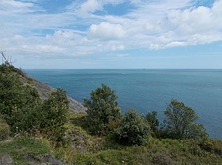
The Undercliff is the name of several areas of landslip on the south coast of England. They include ones on the Isle of Wight; on the Dorset-Devon border near Lyme Regis; on cliffs near Branscombe in East Devon; and at White Nothe, Dorset. All arose from slump of harder strata over softer clay, giving rise to irregular landscapes of peaks, gullies and slipped blocks, that have become densely vegetated due to their isolation and change of land use. The Kent coast at Folkestone and Sandgate also has similar undercliff areas.

<span class="mw-page-title-main">Lake, Isle of Wight</span> Human settlement in England

Lake is a large village and civil parish located on Sandown Bay, on the Isle of Wight, England. It is six miles south-east of Newport situated between Sandown and Shanklin, and 1+12 miles (2.4 km) to the east of the hamlet of Apse Heath.

<span class="mw-page-title-main">Yaverland</span> Human settlement in England

Yaverland is a village and former civil parish, now in the parish of Sandown, on the Isle of Wight, England. It is just north of Sandown on Sandown Bay. It has about 200 houses. About 13 of a mile away from the village is the Yaverland Manor and Church. Holotype fossils have been discovered here of Yaverlandia and a pterosaur, Caulkicephalus. The White Air extreme sports festival was held annually at Yaverland pay and display car park between 1997 and 2008, but moved to Brighton for 2009.

<span class="mw-page-title-main">Luccombe, Isle of Wight</span>

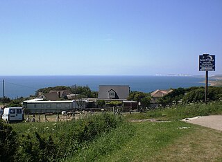
Luccombe is a hamlet a short distance south of Shanklin, on the south coast of the Isle of Wight, England.

<span class="mw-page-title-main">Blackgang</span> Human settlement in England

Blackgang is a village on the south-western coast of the Isle of Wight, England. It is best known as the location of the Blackgang Chine amusement park which sits to the south of St Catherine's Down.

Puckaster is a hamlet on the Isle of Wight, England. Puckaster is on the southern coast of the Isle of Wight, south of Niton, between St. Catherine's Point and Binnel.

<span class="mw-page-title-main">Bonchurch Landslips</span>

<span class="mw-page-title-main">Transport on the Isle of Wight</span> Various transport methods used on the Isle of Wight, England

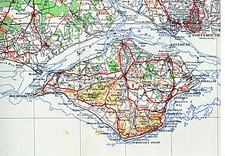
There are several modes of Transport on the Isle of Wight, an island in the English Channel.

<span class="mw-page-title-main">Isle of Wight Coastal Path</span> Long-distance footpath on the Isle of Wight, England

The Isle of Wight Coastal Path is a circular long-distance footpath of 70 miles (113 km) around the Isle of Wight, UK. It follows public footpaths and minor lanes, with some sections along roads.

<span class="mw-page-title-main">Whitecliff Bay</span> Human settlement in England

Whitecliff Bay is a sandy bay near Foreland which is the easternmost point of the Isle of Wight, England, about two miles south-west of Bembridge and just to the north of Culver Down. The bay has a shoreline of around three-quarters of a mile (1.2 km) and has a popular sandy shingle beach which is over half a mile long. It is a tourist site with three holiday parks in the vicinity of the bay; it has two cafes though minimal facilities. Access is limited and only possible down two steeply sloping concrete tracks.

<span class="mw-page-title-main">Luccombe Bay</span> Human settlement in England

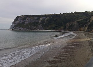
Luccombe Bay is a bay on the south-east coast of the Isle of Wight, England. It lies to the east of Luccombe Village from which it takes its name. It faces south-east towards the English Channel, its shoreline is 23 mile (1.1 km) in length. It consists of a predominantly sand and shingle beach lined with sea cliffs which range from 200 to 280 feet in height. It stretches from Horse Ledge in the north to Bordwood Ledge in the south. The sea bottom is a mixture of mud and rocks.

Many forts and fortifications have been built to protect the Isle of Wight from foreign invasion. Throughout history the island has been a site of key military importance. Controlling both entrances to the Solent and the home of the Royal Navy, Portsmouth. This is a list of most of the fortifications on the island.

The Undercliff, Isle of Wight, England is a tract of semi-rural land, around 5 miles (8.0 km) long by 0.25–0.5 miles (0.40–0.80 km) wide, skirting the southern coast of the island from Niton to Bonchurch. Named after its position below the escarpment that backs this coastal section, its undulating terrain comprises a mix of rough pasture, secondary woodland, parkland, grounds of large isolated houses, and suburban development. Its sheltered south-facing location gives rise to a microclimate considerably warmer than elsewhere on the island. Although inhabited, the Undercliff is an area prone to landslips and subsidence, with accompanying loss of property over time. Settlements along the Undercliff, from west to east, are: lower Niton, Puckaster, St Lawrence, Steephill, the town of Ventnor, and Bonchurch.

References

  1. Google (5 September 2018). "Sandown Bay" (Map). Google Maps . Google. Retrieved 5 September 2018.
  2. 1 2 3 4 "Sandown Bay". eoceanic.com. Retrieved 5 September 2018.
  3. William Page, ed. (1912), "Parishes: Brading", British History Online, retrieved 20 June 2015; "Sandown Castle", Historic England; Adams 1884 , p. 200
  4. "History of Sandown, Isle of Wight". www.sandown-bay.co.uk. Archived from the original on 20 August 2013. Retrieved 5 September 2018.
  5. "Sandown Pier". National Piers Society . Retrieved 4 September 2018.
  6. "Isle of Wight Shoreline Management Plan 2" (PDF). Isle of Wight Council. December 2010.
  7. 1 2 3 4 "Coastal Communities Economic Plan, Sandown Bay" (PDF). Coastal Communities Alliance. May 2016.
  8. "Geotechnical Study Area G9, Sandown Bay Cliffs" (PDF). risknat.org.
  9. "Coastal Path Sandown to Ryde" (PDF). www.visitisleofwight.co.uk.
  10. "2011 Rural-Urban Classification of Local Authority and other higher level geographies for statistical purposes" (PDF). DEFRA. 1 May 2014.
  11. Isle of Wight History and Heritage, the Pacific Glory

Sources