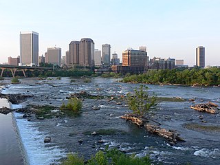
Richmond is the capital city of the Commonwealth of Virginia in the United States. Incorporated in 1742, Richmond has been an independent city since 1871. The city's population in the 2020 census was 226,610, up from 204,214 in 2010, making it Virginia's fourth-most populous city. The Richmond metropolitan area, with over 1.3 million residents, is the Commonwealth's third-most populous.

Henrico County, officially the County of Henrico, is located in the Commonwealth of Virginia in the United States. As of the 2020 census, the population was 334,389 making it the fifth-most populous county in Virginia. Henrico County is included in the Greater Richmond Region. There is no incorporated community within Henrico County; therefore, there is no incorporated county seat either. Laurel, an unincorporated CDP, serves this function.

Glen Allen is a census-designated place (CDP) in Henrico County, Virginia, United States. The population was 16,187 as of the 2020 Census, up from 14,774 at the 2010 census. Areas outside the CDP which use a "Glen Allen" mailing address include residences in neighboring Hanover County.

Highland Springs is a census-designated place (CDP) located in Henrico County, Virginia, United States, 4.3 miles (7 km) east of Richmond. The population was 16,604 at the 2020 census.
The Greater Richmond Region, the Richmond metropolitan area or Central Virginia, is a region and metropolitan area in the U.S. state of Virginia, centered on Richmond. The U.S. Office of Management and Budget (OMB) defines the area as the Richmond, VA Metropolitan Statistical Area, a Metropolitan Statistical Area (MSA) used by the U.S. Census Bureau and other entities. The OMB defines the area as comprising 17 county-level jurisdictions, including the independent cities of Richmond, Petersburg, Hopewell, and Colonial Heights. As of 2020, it had a population of 1,314,434, making it the 44th largest MSA in the country.

The Battle of Seven Pines, also known as the Battle of Fair Oaks or Fair Oaks Station, took place on May 31 and June 1, 1862, in Henrico County, Virginia, nearby Sandston, as part of the Peninsula Campaign of the American Civil War. It was the culmination of an offensive up the Virginia Peninsula by Union Maj. Gen. George B. McClellan, in which the Army of the Potomac reached the outskirts of Richmond.

State Route 156 is a primary state highway in the U.S. state of Virginia. The state highway runs 57.38 miles (92.34 km) from U.S. Route 301 and SR 35 in Templeton north to US 360 Business in Mechanicsville. SR 156 follows a circuitous route through the eastern part of the Richmond–Petersburg metropolitan area. South of the James River, the state highway connects Templeton in Prince George County with Hopewell, which is directly served by SR 156 Business. SR 156 crosses the James River on the Benjamin Harrison Memorial Bridge and briefly passes through Charles City County. For most of its length in Henrico and Hanover, the state highway is a rural road that provides access to several units of Richmond National Battlefield Park. However, SR 156 provides access to Richmond International Airport, Interstate 64 (I-64), and I-295 as it passes through the Richmond suburbs of Sandston and Highland Springs as a major highway.
The Greater Richmond, Virginia area has many neighborhoods and districts.

State Route 33 is a primary state highway in the U.S. state of Virginia. The state highway runs 72.23 miles (116.24 km) from U.S. Route 33 and US 250 in Richmond, Virginia east to Chesapeake Boulevard in Stingray Point. SR 33 is a state-numbered eastward extension of US 33 that connects Richmond with West Point and the Middle Peninsula, one of three large peninsulas on the west side of the Chesapeake Bay in Virginia. The state highway is a major thoroughfare in the downtown and East End areas of Richmond. SR 33 serves a suburban area in eastern Henrico County before running concurrently with US 60, Interstate 64 (I-64), and SR 30 east toward West Point. The state highway heads from West Point through Saluda, east of which SR 33 serves as the main highway of Middlesex County.

Varina is a former unincorporated community and current magisterial district in the easternmost portion of Henrico County, Virginia, United States.
Seven Pines is a community located in the unincorporated town of Sandston in Henrico County, Virginia. Cemetery records state the name is derived from for a group of seven pine trees planted within the national cemetery in 1869 near the intersection of the old Williamsburg-Richmond Stage Road and the Nine Mile Road, however, the name Seven Pines pre-dates the establishment of the cemetery. Earlier maps and records, especially those from the American Civil War, commonly refer to the location as Seven Pines. Today, the surrounding area is still referred to as Seven Pines although it lies within the census-designated place of Sandston and uses Sandston postal addresses.
Seven Pines National Cemetery is a national cemetery located in the Seven Pines area of the unincorporated town of Sandston in Henrico County, Virginia. Cemetery records state the name is derived from for a group of seven pine trees planted within the national cemetery in 1869 near the intersection of the old Williamsburg-Richmond Stage Road and the Nine Mile Road, however, the name Seven Pines pre-dates the establishment of the cemetery.

Transportation in Richmond, Virginia and its immediate surroundings include land, sea and air modes. This article includes the independent city and portions of the contiguous counties of Henrico and Chesterfield. While almost all of Henrico County would be considered part of the Richmond area, southern and eastern portions of Chesterfield adjoin the three smaller independent cities of Petersburg, Hopewell, and Colonial Heights, collectively commonly called the Tri-Cities area. A largely rural section of southwestern Chesterfield may be considered not a portion of either suburban area.

The Henrico County Public Schools school system is a Virginia school division that operates as an independent branch of the Henrico County, Virginia county government and administers public schools in the county. Henrico County Public Schools has five International Baccalaureate schools – John Randolph Tucker High School, Henrico High School, Fairfield Middle School, Tuckahoe Middle School and George H. Moody Middle School.

The Northside is an area composed of northern Richmond, Virginia and some parts of Henrico County, Virginia.
The East End of Richmond, Virginia is the quadrant of the City of Richmond, Virginia, and more loosely the Richmond metropolitan area, east of the downtown.
The following is a timeline of the history of the city of Richmond, Virginia, United States

Joseph Judson Williams Jr. was a Virginia lawyer and banker, who served part-time for more than two decades representing Henrico County, Virginia, in the Virginia House of Delegates. A member of the Byrd Organization, Williams participated in its Massive Resistance to racial integration, but left that political crisis to serve as a member of the Federal Home Loan Bank Board for the three years before his death.