Sandy Creek (village), New York

Last updated
Sandy Creek, New York
Oswego County New York incorporated and unincorporated areas Sandy Creek (village) highlighted.svg
Location in Oswego County and the state of New York.
Coordinates: 43°38′49″N76°5′11″W / 43.64694°N 76.08639°W / 43.64694; -76.08639 Coordinates: 43°38′49″N76°5′11″W / 43.64694°N 76.08639°W / 43.64694; -76.08639
Country United States
State New York
County Oswego
Area
[1]
  Total1.35 sq mi (3.49 km2)
  Land1.35 sq mi (3.49 km2)
  Water0.00 sq mi (0.00 km2)
Elevation
499 ft (152 m)
Population
 (2020)
  Total646
  Density478.87/sq mi (184.91/km2)
Time zone UTC-5 (Eastern (EST))
  Summer (DST) UTC-4 (EDT)
ZIP code
13145
Area code 315
FIPS code 36-65068
GNIS feature ID0964425

Sandy Creek is a village in Oswego County, New York, United States. The population was 771 at the 2010 census.

Contents

The Village of Sandy Creek in the central part of the Town of Sandy Creek. The village is located by U.S. Route 11.

History

The historic core of the village was listed on the National Register of Historic Places in 1983 as the Sandy Creek Historic District. Also listed are the Methodist Church, First Baptist Church, Samuel Sadler House, and Newton M. Pitt House. [2]

Geography

Sandy Creek is located at 43°38′49″N76°5′10″W / 43.64694°N 76.08611°W / 43.64694; -76.08611 (43.647037, -76.086305). [3]

A stream called "Little Sandy Creek" flows past the north side of the village.

According to the United States Census Bureau, the village has a total area of 1.4 square miles (3.7 km2), all land.

Demographics

Historical population
CensusPop.
1870 986
1880 951−3.5%
1890 723−24.0%
1900 692−4.3%
1910 617−10.8%
1920 566−8.3%
1930 64814.5%
1940 646−0.3%
1950 7089.6%
1960 697−1.6%
1970 7314.9%
1980 7654.7%
1990 7933.7%
2000 789−0.5%
2010 771−2.3%
2020 646−16.2%
U.S. Decennial Census [4]

As of the census [5] of 2000, there were 789 people, 311 households, and 208 families residing in the village. The population density was 552.2 people per square mile (213.0/km2). There were 338 housing units at an average density of 236.5 per square mile (91.3/km2). The racial makeup of the village was 98.73% White, 0.51% Native American, 0.13% from other races, and 0.63% from two or more races. Hispanic or Latino of any race were 0.38% of the population.

There were 311 households, out of which 30.2% had children under the age of 18 living with them, 51.8% were married couples living together, 11.3% had a female householder with no husband present, and 32.8% were non-families. 26.4% of all households were made up of individuals, and 11.6% had someone living alone who was 65 years of age or older. The average household size was 2.54 and the average family size was 3.04.

In the village, the population was spread out, with 27.0% under the age of 18, 6.2% from 18 to 24, 28.6% from 25 to 44, 24.8% from 45 to 64, and 13.3% who were 65 years of age or older. The median age was 37 years. For every 100 females, there were 91.5 males. For every 100 females age 18 and over, there were 90.7 males.

The median income for a household in the village was $34,167, and the median income for a family was $47,188. Males had a median income of $35,417 versus $20,000 for females. The per capita income for the village was $17,297. About 12.8% of families and 17.5% of the population were below the poverty line, including 23.7% of those under age 18 and 18.9% of those age 65 or over.

Related Research Articles

<span class="mw-page-title-main">Kenney, Illinois</span> Village in Illinois, United States

Kenney is a village in DeWitt County, Illinois, United States. The population was 326 at the 2010 census. It was named for its founder, Moses Kenney.

<span class="mw-page-title-main">Rock Falls, Iowa</span> City in Iowa, United States

Rock Falls is a city in Cerro Gordo County, Iowa, United States, along the Shell Rock River. The population was 150 at the time of the 2020 census. It is part of the Mason City Micropolitan Statistical Area.

<span class="mw-page-title-main">Shoal Creek Estates, Missouri</span> Village in Missouri, United States

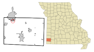
Shoal Creek Estates is a village in Newton County, Missouri, United States. The population was 76 at the 2010 census. It is part of the Joplin, Missouri Metropolitan Statistical Area.

<span class="mw-page-title-main">El Rancho, New Mexico</span> Census-designated place in New Mexico, United States

El Rancho is a census-designated place (CDP) in Santa Fe County, New Mexico, United States. It is part of the Santa Fe, New Mexico Metropolitan Statistical Area. The population was 1,199 at the 2010 census.

<span class="mw-page-title-main">Jordan, New York</span> Village in New York, United States

Jordan is a village in Onondaga County, New York, United States. The population was 1,368 at the 2010 census. It is part of the Syracuse Metropolitan Statistical Area. It was named after the Jordan River.

<span class="mw-page-title-main">Mattydale, New York</span> Census-designated place in New York, United States

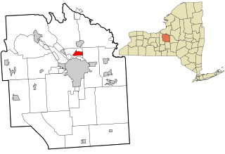
Mattydale is a hamlet in Onondaga County, New York, United States. The population was 6,446 at the 2010 census.

<span class="mw-page-title-main">Lacona, New York</span> Village in New York, United States

Lacona is a village in Oswego County, New York, United States. The population was 582 at the 2010 census.

Burdett is a village in Schuyler County, New York, United States. The population was 357 at the 2000 census.

<span class="mw-page-title-main">West Rushville, Ohio</span> Village in Ohio, United States

West Rushville is a village in Fairfield County, Ohio, United States. The population was 134 at the 2010 census.

<span class="mw-page-title-main">Black Creek Township, Luzerne County, Pennsylvania</span> Township in Pennsylvania, United States

Black Creek Township is a township in Luzerne County, Pennsylvania, United States. The population was 1,904 as of the 2020 census.

<span class="mw-page-title-main">Forks Township, Sullivan County, Pennsylvania</span> Township in Pennsylvania, United States

Forks Township is a township in Sullivan County, Pennsylvania, United States. The population was 372 at the 2020 census.

<span class="mw-page-title-main">Clarks Hill, South Carolina</span> CDP in South Carolina, United States

Clarks Hill is a census-designated place (CDP) in McCormick County, South Carolina, United States. The population was 376 at the 2000 census.

<span class="mw-page-title-main">La Grulla, Texas</span> City in Texas, United States

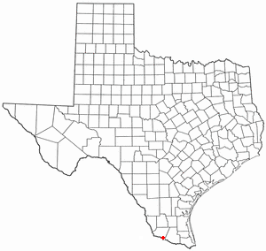
La Grulla is a city in Starr County, Texas, United States, founded by Juan Santiago Longoria in 1836. The population was 1,622 at the 2010 census.

Adams is a village in the town of Adams in Jefferson County, New York, United States. The population was 1,775 at the 2010 census. The village is named after President John Adams.

Ellisburg is a village in Jefferson County, New York, United States. The population was 244 at the 2010 census. The village is named after two brothers who were the original landowners. It is located near the middle of the town of Ellisburg and is southwest of Watertown.

<span class="mw-page-title-main">Camillus (village), New York</span> Village in New York, United States

Camillus is a village in Onondaga County, New York, United States. The population was 1,213 at the 2010 census. The village takes its name from the town in which it is located. It is part of the Syracuse Metropolitan Statistical Area.

<span class="mw-page-title-main">Elbridge (village), New York</span> Village in New York, United States

Elbridge is a village located in the western part of the town of Elbridge in western Onondaga County, New York, United States, about 15 miles (24 km) west of Syracuse. It is part of the Syracuse Metropolitan Statistical Area. As of the 2010 census, the village's total population was 1,058.

<span class="mw-page-title-main">Constantia (CDP), New York</span> CDP in New York, United States

Constantia is a census-designated place (CDP) in the town of Constantia in Oswego County, New York, United States. Located on Oneida Lake, the community lies along State Route 49 and Scriba Creek. The population was 1,182 at the 2010 census.

<span class="mw-page-title-main">Parish (village), New York</span> Village in New York, United States

Parish is a village located in the town of Parish, in Oswego County, New York, United States. This village is part of the Syracuse metropolitan area. Its population was 450 as of the census of 2010.

<span class="mw-page-title-main">Sandy Creek, New York</span> Town in New York, United States

Sandy Creek is a town in Oswego County, New York, United States. The population was 3,939 at the time of the 2010 census. The name is derived from a creek in the area.

References

  1. "ArcGIS REST Services Directory". United States Census Bureau. Retrieved September 20, 2022.
  2. "National Register Information System". National Register of Historic Places . National Park Service. March 13, 2009.
  3. "US Gazetteer files: 2010, 2000, and 1990". United States Census Bureau. 2011-02-12. Retrieved 2011-04-23.
  4. "Census of Population and Housing". Census.gov. Retrieved June 4, 2015.
  5. "U.S. Census website". United States Census Bureau . Retrieved 2008-01-31.