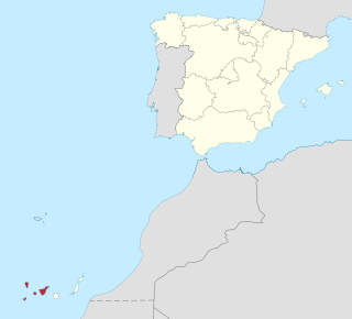
The Canary Islands, also known informally as the Canaries, are a Spanish autonomous community and archipelago in Macaronesia in the Atlantic Ocean. At their closest point to the African mainland, they are 100 kilometres west of Morocco. They are the southernmost of the autonomous communities of Spain. The islands have a population of 2.2 million people and are the most populous special territory of the European Union.
Province of Santa Cruz de Tenerife, also Province of Santa Cruz, is a province of Spain, consisting of the western part of the autonomous community of the Canary Islands. It consists of about half of the Atlantic archipelago: the islands of Tenerife, La Gomera, El Hierro, and La Palma. It occupies an area of 3,381 km2 (1,305 sq mi). It also includes a series of adjacent roques.

Gran Canaria, also Grand Canary Island, is the third-largest and second-most-populous island of the Canary Islands, an archipelago off the Atlantic coast of Northwest Africa and is part of Spain. As of 2019 the island had a population of 851,231 that constitutes approximately 40% of the population of the archipelago. Las Palmas de Gran Canaria, the capital of the island, is the biggest city of the Canary Islands and the ninth of Spain.

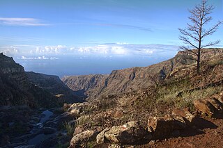
La Palma, also known as La isla bonita and historically San Miguel de La Palma, is the most northwesterly island of the Canary Islands, Spain. La Palma has an area of 708 square kilometres (273 sq mi) making it the fifth largest of the eight main Canary Islands. The total population at the end of 2020 was 85,840, of which 15,716 lived in the capital, Santa Cruz de La Palma and about 20,467 in Los Llanos de Aridane. Its highest mountain is the Roque de los Muchachos, at 2,426 metres (7,959 ft), being second among the peaks of the Canaries after the Teide massif on Tenerife.

Agaete is a municipality of Las Palmas province, on the Canary Islands, Spain.

Puerto del Rosario is a town and a municipality in the eastern part of the island of Fuerteventura in the Las Palmas province in the Canary Islands. It has been the capital of Fuerteventura since 1860. The town's population is 29,160 (2013), the administrative district's population is 36,744 and its area is 289.95 km².

La Matanza de Acentejo is a town near the north coast of Tenerife, Canary Islands, Spain. It is located 10 km east of Puerto de la Cruz, and about 20 km west of the island's capital, Santa Cruz de Tenerife. Its name means "the Slaughter of Acentejo" in Spanish, and refers to the 1494 First Battle of Acentejo, lost by the Spanish.

San Sebastián de La Gomera is the capital and a municipality of La Gomera in the Canary Islands, Spain. It also hosts the main harbour. The population was 8,699 in 2013, and the area is 113.59 square kilometres (43.86 sq mi).
Vallehermoso is a village and municipality in the western part of the island La Gomera in the province of Santa Cruz de Tenerife of the Canary Islands, Spain. The town of Vallehermoso, the seat of the municipality, is situated in the northern part of the municipality, 3 km from the coast and 18 km northwest of the island capital, San Sebastián de la Gomera.

Fuencaliente de La Palma, also Fuencaliente, is a municipality in the southern part of the island La Palma in the province of Santa Cruz de Tenerife of the Canary Islands, Spain. The seat of the municipality is the village Los Canarios. It has been the seat since 1837. The population of the municipality is 1,798 (2013) and the area is 56.42 km².

Villa de Mazo is a town and a municipality on the island of La Palma, Province of Santa Cruz de Tenerife, Canary Islands, Spain. It is situated in the southeastern part of the island. The population of the municipality is 4,858 (2013) and the area is 71.17 km². Villa de Mazo is 9 km south of the island capital Santa Cruz de La Palma. La Palma Airport is located on the coast of Villa de Mazo.

Breña Baja is a municipality on the eastern side of the island of La Palma, in the province of Santa Cruz de Tenerife, in the Canary Islands. The ayuntamiento is in the town of San José with an elevation of 300 m. Until the 17th century the area was known as Breña, but was then divided into Breña Alta and Breña Baja.

Breña Alta is a municipality on the eastern side of the island of La Palma, in the province of Santa Cruz de Tenerife, in the Canary Islands. The ayuntamiento is in the town of San Pedro, at 350 m above sea-level, and only 9 km south of the island's capital Santa Cruz de la Palma. Breña Alta lies on the main highway encircling the island, just north of La Palma Airport. Until the 17th century the area was known as Breña, but was then divided into Breña Alta and Breña Baja.

Puntallana is a town and a municipality on the island of La Palma, Province of Santa Cruz de Tenerife, Canary Islands, Spain. It is situated in the northeastern part of the island. The population of the municipality is 2,346 (2013) and the area is 35.10 km². The elevation is 420 m. Puntallana is 7 km northeast of the island capital Santa Cruz de La Palma.

San Andrés y Sauces is a municipality on the island of La Palma, Province of Santa Cruz de Tenerife, Canary Islands, Spain. It is situated in the northeastern part of the island. The population of the municipality is 4,473 (2013) and the area is 42.75 km². The elevation of the largest village Los Sauces is 250 m. Los Sauces is 14 km north of the island capital Santa Cruz de La Palma. The municipality takes its name from the villages Los Sauces and San Andrés, 1.5 km southeast of Los Sauces, at the coast.

Tijarafe is a town and a municipality on the island of La Palma, Province of Santa Cruz de Tenerife, Canary Islands, Spain. It is situated in the northwestern part of the island. The population of the municipality is 2,776 (2013) and the area is 53.76 km². Tijarafe is 7 km northwest of Los Llanos de Aridane and 19 km west of the island capital Santa Cruz de La Palma.

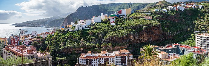
Los Llanos de Aridane is a municipality of the Province of Santa Cruz de Tenerife, Canary Islands, Spain. It is located in the west of the island of La Palma, in the Aridane Valley. With 20,930 inhabitants (2013) it is the most populous municipality of La Palma.

Sociedad Deportiva Tenisca is a Spanish football team club from the city of Santa Cruz de La Palma, on the island of La Palma. It was founded in 1922 and currently plays in Tercera División RFEF – Group 12, holding home games at Estadio Virgen de las Nieves, with a 5,500-seat capacity.

Betancuria is a small town and a municipality in the western part of the island of Fuerteventura in the Province of Las Palmas, Canary Islands, Spain. The population is 811 (2013), and the area is 103.64 km2 (40 sq mi). It is situated in a mountainous region, 4 km (2 mi) west of Antigua and 21 km (13 mi) southwest of the island capital Puerto del Rosario. By population it is the smallest municipality in Fuerteventura as well as all of the Canary Islands. Betancuria is named after Jean de Béthencourt, who founded the town in 1404 with Gadifer de La Salle. It was the original capital of the Kingdom of the Canary Islands, and later capital of Fuerteventura.

The Castillo de Santa Catalina is a castle in Santa Cruz de La Palma on the island of La Palma in the Canary Islands. The original castle was constructed in 1554–1560 after the city was attacked by French pirates in 1553. The current castle was constructed between 1685 and 1692 and was recorded as a historical monument in 1951. It has been privately owned since 1949 and is open to the public.