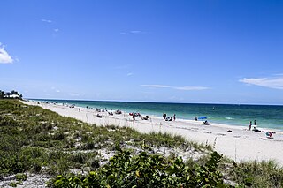
Manasota Key is a census-designated place (CDP) consisting mainly of the community of Englewood Beach in Charlotte County, Florida, United States. The population of the CDP was 1,326 at the 2020 census. It is part of the Sarasota-Bradenton-Punta Gorda Combined Statistical Area.
Cortez, a census-designated place (CDP) in Manatee County, Florida, United States, is a small Gulf Coast commercial fishing village that was founded by settlers from North Carolina in the 1880s. The population was 4,121 at the 2020 census. It is part of the Bradenton-Sarasota-Venice, Florida Metropolitan Statistical Area.

Longboat Key is a town in Manatee and Sarasota counties along the central west coast of the U.S. state of Florida, located on and coterminous with the barrier island of the same name. Longboat Key is south of Anna Maria Island, between Sarasota Bay and the Gulf of Mexico. It is almost equally divided between the Manatee and Sarasota counties. The town of Longboat Key was incorporated in 1955 and is part of the Bradenton-Sarasota-Venice, Florida Metropolitan Statistical Area. The town's population was 7,505 at the 2020 census.

Sarasota is a city in and the county seat of Sarasota County, Florida, United States. It is located in Southwest Florida, the southern end of the Greater Tampa Bay Area, and north of Fort Myers and Punta Gorda. Its official limits include Sarasota Bay and several barrier islands between the bay and the Gulf of Mexico. Sarasota is a principal city of the Sarasota metropolitan area. According to the 2020 U.S. census, Sarasota had a population of 54,842.

Galveston Bay is a bay in the western Gulf of Mexico along the upper coast of Texas. It is the seventh-largest estuary in the United States, and the largest of seven major estuaries along the Texas Gulf Coast. It is connected to the Gulf of Mexico and is surrounded by sub-tropical marshes and prairies on the mainland. The water in the bay is a complex mixture of sea water and fresh water, which supports a wide variety of marine life. With a maximum depth of about 10 feet (3 m) and an average depth of only 6 feet (2 m), it is unusually shallow for its size.
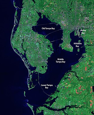
Tampa Bay is a large natural harbor and shallow estuary connected to the Gulf of Mexico on the west-central coast of Florida, comprising Hillsborough Bay, McKay Bay, Old Tampa Bay, Middle Tampa Bay, and Lower Tampa Bay. The largest freshwater inflow into the bay is the Hillsborough River, which flows into Hillsborough Bay in downtown Tampa. Many other smaller rivers and streams also flow into Tampa Bay, resulting in a large watershed area.

The Caloosahatchee River is a river on the southwest Gulf Coast of Florida in the United States, approximately 67 miles (108 km) long. It drains rural areas on the northern edge of the Everglades, east of Fort Myers. An important link in the Okeechobee Waterway, a manmade inland waterway system of southern Florida, the river forms a tidal estuary along most of its course and has become the subject of efforts to restore and preserve the Everglades.
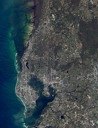
The Tampa Bay area is a major metropolitan area surrounding Tampa Bay on the Gulf Coast of Florida in the United States. It includes the main cities of Tampa, St. Petersburg, and Clearwater. It is the 17th-largest metropolitan area in the United States, with a population of 3,175,275 as of the 2020 U.S. Census.

The Lower Suwannee National Wildlife Refuge (LSNWR) is part of the United States National Wildlife Refuge System. It is located in southeastern Dixie and northwestern Levy counties on the western coast of Florida, approximately fifty miles southwest of the city of Gainesville.
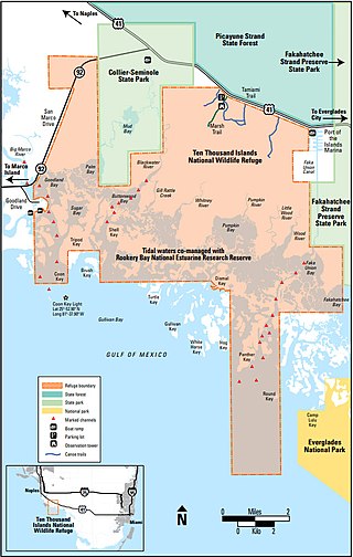
The Ten Thousand Islands are a chain of islands and mangrove islets off the coast of southwest Florida, between Cape Romano and the mouth of the Lostmans River. Some of the islands are high spots on a submergent coastline. Others were produced by mangroves growing on oyster bars. Despite the name, the islets in the chain only number in the hundreds.

The Texas Coastal Bend, or just the Coastal Bend, is a geographical region in the US state of Texas. The name refers to the area being a curve along the Texas Gulf Coast of the Gulf of Mexico. The largest city of the Coastal Bend is Corpus Christi. It includes the Nueces Estuary and the Mission–Aransas Estuary, as well as part of Laguna Madre. The coastline is paralleled by several of the Texas barrier islands, including North Padre Island, Mustang Island, and San José Island.

State Road 789 is a 17.5-mile-long road along the Florida’s Gulf Coast that spans Bird Key, St. Armands Key, and Lido Key, in Sarasota; Longboat Key ; and Anna Maria Island. The southern terminus is the intersection of the John Ringling Causeway and the Tamiami Trail in Sarasota; the northern terminus is the intersection of Gulf Drive, North and Manatee Avenue., West in Holmes Beach. Much of the northernmost five miles (8 km) has been designated Bradenton Beach Scenic Highway.
The Manatee River is a 36-mile-long (58 km) river in Manatee County, Florida. The river forms in the northeastern corner of Manatee County and flows into the Gulf of Mexico at the southern edge of Tampa Bay.

Crystal River is a very short river in Citrus County, Florida, flowing into the Gulf of Mexico. It is just seven miles long, and has a drainage basin of five square miles, joining Kings Bay to the Gulf of Mexico. The river's significance is in the thirty natural springs that add an average of 300 million gallons of warm water to the river every day. These springs include Three Sisters Springs.

The Myakka River is a river in southwestern Florida. It arises near the Hardee-Manatee county line and flows southwest and then southeast through Manatee, Sarasota and Charlotte counties to Charlotte Harbor, an arm of the Gulf of Mexico. The river is 72 miles (116 km) long and has a drainage basin of 602 square miles, of which 314.7 square miles (815 km2) lies in Sarasota county. The last 20 miles (32 km) of the river is tidal and brackish.

The Waccasassa River is a small, isolated river in Levy County, Florida, flowing through the Gulf Hammock wetlands and emptying into the Gulf of Mexico. The river is 29 miles (47 km) long, and has a drainage basin of 610 square miles (1,600 km2). Three-quarters of the river is accessible only by canoe or kayak.
Rookery Bay Reserve protects 110,000 acres of coastal lands and waters at the northern end of the Ten Thousand Islands on the gulf coast of Florida, Rookery Bay National Estuarine Research Reserve represents one of the few remaining undisturbed mangrove estuaries in North America.
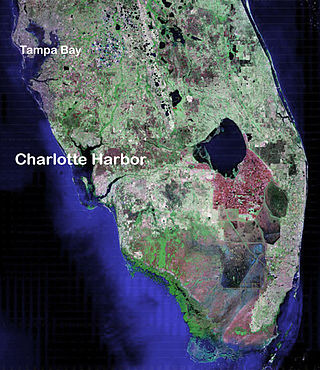
Charlotte Harbor Estuary, the second largest bay in Florida, is located on the Gulf of Mexico coast of west Florida with two thirds lying in Charlotte County, Florida and one in Lee County. The harbor's mouth is located behind Gasparilla Island, one of the many coastal barrier islands on the southwest coast of Florida, with access from the Gulf of Mexico through the Boca Grande Pass between Gasparilla Island on the north and Lacosta Island on the south. Charlotte Harbor covers about 270 sq mi (700 km2)
Homosassa River is a 7.7-mile-long (12.4 km) river in Citrus County, Florida, in the western part of the state. Its headwaters are the Homosassa Springs, and from there it flows west into the Gulf of Mexico. The river is home to common bottlenose dolphins, West Indian manatees, alligator snapping turtles, nine-banded armadillos, snakes, birds, eastern box turtles, oysters, raccoons, American alligators, Virginia opossums, North American river otters and many species of both freshwater and saltwater fish. The Homosassa River is an estuary, which means that as it moves inland, it changes from salt water to fresh very gradually, and the river is brackish. The river is good for canoeing and kayaking.

The U.S. state of Texas has a series of estuaries along its coast on the Gulf of Mexico, most of them bounded by the Texas barrier islands. Estuaries are coastal bodies of water in which freshwater from rivers mixes with saltwater from the sea. Twenty-one drainage basins terminate along the Texas coastline, forming a chain of seven major and five minor estuaries: listed from southwest to northeast, these are the Rio Grande Estuary, Laguna Madre, the Nueces Estuary, the Mission–Aransas Estuary, the Guadalupe Estuary, the Colorado–Lavaca Estuary, East Matagorda Bay, the San Bernard River and Cedar Lakes Estuary, the Brazos River Estuary, Christmas Bay, the Trinity–San Jacinto Estuary, and the Sabine–Neches Estuary. Each estuary is named for its one or two chief contributing rivers, excepting Laguna Madre, East Matagorda Bay, and Christmas Bay, which have no major river sources. The estuaries are also sometimes referred to by the names of their respective primary or central water bodies, though each also includes smaller secondary bays, inlets, or other marginal water bodies.