Sarntal Alps

Last updated
Sarntal Alps
RitzlarFromNW.jpg
The Sarntal east ridge rarely forms rugged peaks, in the picture: Ritzlar, 2528 m.
Highest point
PeakHirzer (Sarntal Alps)
Elevation 2,781 m (9,124 ft)
Coordinates 46°44′13″N11°16′35″E / 46.73694°N 11.27639°E / 46.73694; 11.27639
Geography
CountryItaly
State South Tyrol
Parent range Eastern Rhaetian Alps,
Central Eastern Alps

The Sarntal Alps (German : Sarntaler Alpen, Italian: Alpi Sarentine) are a mountain range of the Eastern Rhaetian Alps, in South Tyrol (Italy), which surrounds the Sarntal (valley). It is limited by the Etschtal, Eisacktal, Passeiertal and the Jaufen Pass. [1]

Contents

Topography

The Sarntal Alps are divided into an Eastern and a Western Part, which meet at the Penser Joch. The Eastern Part has got various minor ridges.

Eastern Part

The Southern half (south to Kassianspitze) is compared to the surrounding ranges not that elevated, its highest peaks are Villanderer Berg (2509m) and Rittner Horn (2260m), further south it becomes the Ritten. [1]

The northern has got the Tatschspitze (2528m), Tagewaldhorn (2708m), Jakobsspitze (2742m), Schrotthorn (2590m), Plankenhorn (2543m) Kassianspitze (2581m). [2]

The biggest minor ridge of the Sarntal Alps is the Middle Ridge, beginning at the Hörtlanerspitze (2660m), [3] it limites the Durnholztal. Its most known peaks are Gentersbergspitze (2411m), Hoferspitze (2438m) and Leiterspitze (2375m), which is its last peak. The other minor ridge to the west is the Getrumkamm, with its peaks Plankenhorn (2589 m) and Getrumspitze. [2]

The minor ridges on the Eisack side are due to Flaggertal and Schalderer Tal. Limited to the north by Flaggertal and to the south by Schalderer Tal exists a ridge with Karspitze (2517m) as its highest peak and limited to the north by Schalderer Tal exists a ridge with Lorenzispitze (2483m) and Königsangerspitze (2439m). [2]

Western Part

Hirzer from the southwest Schenna Hirzer from Klammeben.jpg
Hirzer from the southwest

The southern half is not that elevated, it is called Tschöggelberg. [1]

Its middle part consists of the highest mountains, that among the Hirzer (2781m), Alplerspitze (2750m), Hönigsspitze (2698m) and Plattinger Spitze (2670m). More to the west, there is the Ifinger. [2]

The most notable mountains of the northern part are the Penser Weißhorn (2705 m), Zinseler (2422m), Jaufenspitze (2481m), Hochwart (2748m) and Ötsch (2592m). [2]

Sights

The churchhouse Latzfonser Kreuz  [ de ] is one of the highest located (2,311m) places of pilgrimage in South Tyrol.

At the southern side of the Ritten, the natural phenomenum of hoodoo can be seen. [1]

Related Research Articles

<span class="mw-page-title-main">Ritten</span> Comune in Trentino-Alto Adige/Südtirol, Italy

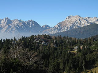
Ritten is a comune (municipality) in South Tyrol in northern Italy.

<span class="mw-page-title-main">Kamnik–Savinja Alps</span> Mountain range in Slovenia and Austria

The Kamnik–Savinja Alps are a mountain range of the Southern Limestone Alps. They lie in northern Slovenia, except for the northernmost part, which lies in Austria.

<span class="mw-page-title-main">Wildspitze</span> Mountain in Austria

Wildspitze is the highest mountain in the Ötztal Alps and in North Tyrol, as well as the second highest mountain in Austria after the Großglockner and in terms of prominence is the fourth summit of the Alps and the fifteenth of Europe.

<span class="mw-page-title-main">Bavarian Alps</span> Series of mountain ranges in the German state of Bavaria

The Bavarian Alps is a collective name for several mountain ranges of the Northern Limestone Alps within the German state of Bavaria.

<span class="mw-page-title-main">Ötztal Alps</span>

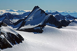
The Ötztal Alps are a mountain range in the Central Eastern Alps, in the State of Tyrol in western Austria and the Province of South Tyrol in northern Italy.

<span class="mw-page-title-main">Kreuzeck group</span> Mountain range

The Kreuzeck Group is a mountain range of the Central Eastern Alps. It may be considered either a separate range or part of the larger High Tauern chain. Administratively, the range belongs to the Austrian states of Carinthia and, in the westernmost part, Tyrol.

<span class="mw-page-title-main">Allgäu Alps</span> Mountain range in the Northern Limestone Alps

The Allgäu Alps are a mountain range in the Northern Limestone Alps, located in Bavaria and Baden-Württemberg in Germany and Tyrol and Vorarlberg in Austria. The range lies directly east of Lake Constance.

<span class="mw-page-title-main">Jakobsspitze</span> Mountain in Italy

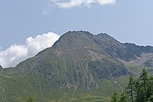
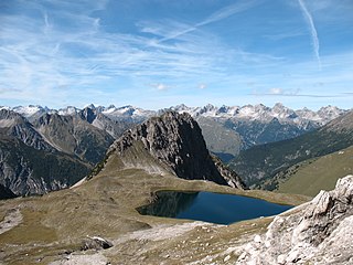
The Jakobsspitze is a mountain in the Sarntal Alps in South Tyrol, Italy.

<span class="mw-page-title-main">Kassianspitze</span> Mountain in Italy

The Kassianspitze is a mountain in the Sarntal Alps in South Tyrol, Italy.

<span class="mw-page-title-main">Tagewaldhorn</span> Mountain in Italy

The Tagewaldhorn is a mountain in the Sarntal Alps in South Tyrol, Italy.

<span class="mw-page-title-main">Ammergau Alps</span>

The Ammergau Alps are a mountain range in the Northern Limestone Alps in the states of Bavaria (Germany) and Tyrol (Austria). They cover an area of about 30 x 30 km and begin at the outer edge of the Alps. The highest summit is the Daniel which has a height of 2,340 metres (7,680 ft).

<span class="mw-page-title-main">Eastern Rhaetian Alps</span>

The Eastern Rhaetian Alps are a mountain range in the central part of the Alps.

<span class="mw-page-title-main">Carnic and Gailtal Alps</span>

The Carnic and Gailtal Alps is a geographic grouping of mountain ranges belonging to the Southern Limestone Alps. They are located in Austria and Italy.

<span class="mw-page-title-main">Villgraten Mountains</span>

The Villgraten Mountains or Deferegg Alps, also called the Defreggen Mountains are a subgroup of the Austrian Central Alps within the Eastern Alps of Europe. Together with the Ankogel Group, the Goldberg Group, the Glockner Group, the Schober Group, the Kreuzeck Group, the Granatspitze Group, the Venediger Group and the Rieserferner Group, the Villgraten Mountains are part of the major mountain range, the High Tauern. Their highest summit is the Weiße Spitze with a height of 2,962 m above sea level (AA).

<span class="mw-page-title-main">Gailtal Alps</span>

The Gailtal Alps, is a mountain range of the Southern Limestone Alps in Austria. It rises between the River Drava (Drau) and the Gail valley and through the southern part of East Tyrol. Its western group called "Lienz Dolomites", is sometimes counted as part of this range and sometimes seen as separate.

<span class="mw-page-title-main">Fiemme Mountains</span> Mountain range in Italy

The Fiemme Mountains, sometimes also the Fleimstal Alps or Fiemme Dolomites, are a mountain range of the Southern Limestone Alps in the Italian region of Trentino-South Tyrol. The range was named after the Fiemme Valley.

<span class="mw-page-title-main">Hornbach chain</span>

The Hornbach chain is a string of mountains, about 15 kilometres long, in the Allgäu Alps in the Austrian state of Tyrol.

<span class="mw-page-title-main">Ritten (mountain)</span>

The Ritten is a mountain ridge in the southeast of the Sarntal Alps in South Tyrol. It is bordered in the west by Sarntal, in the east by Eisacktal and in the south by the Bozner basin. In the north, it is dominated by the Rittner Horn (2,260 m). The approximately 900 to 1,300 m high settlements on the mountain ridge belong to the municipality of the same name Ritten.

Kreuzjoch is the name of many summits and several mountain passes, predominantly in the Eastern Alps.

References

  1. 1 2 3 4 "Sarntaler Alpen - Südtirol". suedtirolerland.it (in German). Retrieved 2019-03-18.
  2. 1 2 3 4 5 Hofer, Tom. "Sarntaler Alpen: Große Karte mit den Grenzen und Hütten, Gipfeln sowie Touren der Gebirgsgruppe". Deine Berge - Hütten, Touren, Gipfel (in German). Retrieved 2019-03-18.
  3. Sarntaler Alpen = Monti Sarentini., Tabacco, 2013, ISBN   9788883150548, OCLC   908150134

Commons-logo.svg Media related to Sarntal Alps at Wikimedia Commons