
Sarsen stones are silicified sandstone blocks found extensively across southern England on the Salisbury Plain and the Marlborough Downs in Wiltshire; in Kent; and in smaller quantities in Berkshire, Essex, Oxfordshire, Dorset, and Hampshire.
Sarsen stones are silicified sandstone blocks found extensively across southern England on the Salisbury Plain and the Marlborough Downs in Wiltshire; in Kent; and in smaller quantities in Berkshire, Essex, Oxfordshire, Dorset, and Hampshire.
Sarsen stones are the post-glacial [1] remains of a cap of Cenozoic silcrete that once covered much of southern England. This is thought to have formed during Neogene to Quaternary weathering by the silicification of Upper Paleocene Lambeth Group sediments, resulting from acid leaching. [2]
There are several potential sources for the word "sarsen."
The first is that word "sarsen" is a shortening of "Saracen stone" which arose in the Wiltshire dialect. In the Middle Ages, "Saracen" was a common name for Muslims, and came by extension to be used for anything regarded as non-Christian, whether Muslim or pagan in contrast to Christianity. [3]
The second is that "sarsen" is vernacular variation of the Indo-European "sasan," name given to the prehistoric vaults of the Chotanagpur plateau of Northern India. [4]
The third possibility is that "sarsen" comes from the hybrid Anglo-Saxon "sar-stan" or 'troublesome stone.' "Sar" has the meaning of 'grievous.' [4]
The builders of Stonehenge used these stones for the Heel Stone and sarsen circle uprights. [5] [6] Avebury and many other megalithic monuments in southern England are also built with sarsen stones. [7]
While sarsen stones are not an ideal building material, fire and in later times explosives were sometimes employed to break the stone into pieces of a suitable size for use in construction. William Stukeley wrote that sarsen is "always moist and dewy in winter which proves damp and unwholesome, and rots the furniture". [8] [9] In the case of Avebury, the investors who backed a scheme to recycle the stone were bankrupted when the houses they built proved to be unsaleable and also prone to burning down. However, despite these problems, sarsen remained highly prized for its durability, being a favoured material for steps and kerb stones.

Stonehenge is a prehistoric megalithic structure on Salisbury Plain in Wiltshire, England, two miles (3 km) west of Amesbury. It consists of an outer ring of vertical sarsen standing stones, each around 13 feet (4.0 m) high, seven feet (2.1 m) wide, and weighing around 25 tons, topped by connecting horizontal lintel stones. Inside is a ring of smaller bluestones. Inside these are free-standing trilithons, two bulkier vertical sarsens joined by one lintel. The whole monument, now ruinous, is aligned towards the sunrise on the summer solstice and sunset on the winter solstice. The stones are set within earthworks in the middle of the densest complex of Neolithic and Bronze Age monuments in England, including several hundred tumuli.

Avebury is a village and civil parish in Wiltshire, England. The village is about 5.5 miles (9 km) west of Marlborough and 8 miles (13 km) northeast of Devizes. Much of the village is encircled by the prehistoric monument complex also known as Avebury. The parish also includes the small villages of Avebury Trusloe and Beckhampton, and the hamlet of West Kennett.
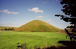
Silbury Hill is a prehistoric artificial chalk mound near Avebury in the English county of Wiltshire. It is part of the Stonehenge, Avebury and Associated Sites UNESCO World Heritage Site. At 39.3 metres (129 ft) high, the hill is the tallest prehistoric man-made mound in Europe and one of the largest in the world; it is similar in volume to contemporary Egyptian pyramids. The site is in the care of English Heritage.

Avebury is a Neolithic henge monument containing three stone circles, around the village of Avebury in Wiltshire, in south-west England. One of the best-known prehistoric sites in Britain, it contains the largest megalithic stone circle in the world. It is both a tourist attraction and a place of religious importance to contemporary pagans.

The Sanctuary was a stone and timber circle near the village of Avebury in the south-western English county of Wiltshire. Excavation has revealed the location of the 58 stone sockets and 62 post-holes. The ring was part of a tradition of stone circle construction that spread throughout much of Britain, Ireland, and Brittany during the Late Neolithic and Early Bronze Age, over a period between 3300 and 900 BCE. The purpose of such monuments is unknown, although archaeologists speculate that the stones represented supernatural entities for the circle's builders.

The North Wessex Downs National Landscape is located in the English counties of Berkshire, Hampshire, Oxfordshire and Wiltshire. The name North Wessex Downs is not a traditional one, the area covered being better known by various overlapping local names, including the Berkshire Downs, the North Hampshire Downs, the White Horse Hills, the Lambourn Downs, the Marlborough Downs, the Vale of Pewsey and Savernake Forest.

East Kennett is a small village and civil parish in Wiltshire, England, 5 miles (8.0 km) west of Marlborough. The United Kingdom Census 2011 recorded a parish population of 84.
Fyfield may refer to:

Fyfield is a village and civil parish in the English county of Wiltshire, in the Kennet Valley about 2.5 miles (4.0 km) west of Marlborough. The village is on the A4 road which was historically the main route from London to the west of England.

West Overton is a village and civil parish in the English county of Wiltshire, about 3.5 miles (5.6 km) west of Marlborough. The river Kennet runs immediately north of the village, separating it from the A4 road. The parish includes the village of Lockeridge, also near the river, further east (downstream).
Lockeridge is a village in Wiltshire, England. It lies at the edge of the West Woods in the Kennet Valley, 2.9 miles (4.7 km) west of Marlborough, 3.1 miles (5.0 km) east of Avebury and 10.5 miles (16.9 km) south of Swindon. It is 0.6 miles (0.97 km) south of the A4 road which was historically the main route from London to the west of England. Lockeridge Dene is a hamlet immediately southwest of the village.

Wiltshire is a historic county located in the South West England region. Wiltshire is landlocked and is in the east of the region.

Hertfordshire puddingstone is a conglomerate sedimentary rock composed of rounded flint pebbles cemented together by a younger matrix of silica quartz. The distinctive rock is largely confined to the English counties of Buckinghamshire and Hertfordshire but small amounts occur throughout the London Basin. It is quite commonly found in fields in and around Chesham, where pieces can be seen as boundary stones and in rockeries. Despite a superficial similarity to concrete, it is an entirely natural silcrete. A fracture runs across both the pebbles and the sandy matrix as both have equal strength unlike concrete where the pebbles remain whole and a fracture occurs only in the matrix. Like other puddingstones, it derives its name from the manner in which the embedded flints resemble the plums in a pudding. It forms the local base of the Upnor Formation of the Lambeth Group.
Robin Hood’s Ball is a Neolithic causewayed enclosure on Salisbury Plain in Wiltshire, England, approximately 5 miles (8 km) northwest of the town of Amesbury, and 2+1⁄2 miles (4.0 km) northwest of Stonehenge. The site was designated as a scheduled monument in 1965.
Stonehenge, Avebury and Associated Sites is a UNESCO World Heritage Site (WHS) in Wiltshire, England. The WHS covers two large areas of land separated by about 24 kilometres (15 mi), rather than a specific monument or building. The sites were inscribed as co-listings in 1986. Some large and well known monuments within the WHS are listed below, but the area also has an exceptionally high density of small-scale archaeological sites, particularly from the prehistoric period. More than 700 individual archaeological features have been identified. There are 160 separate scheduled monuments, covering 415 items or features.

Silcrete is an indurated soil duricrust formed when surface soil, sand, and gravel are cemented by dissolved silica. The formation of silcrete is similar to that of calcrete, formed by calcium carbonate, and ferricrete, formed by iron oxide. It is a hard and resistant material, and though different in origin and nature, appears similar to quartzite. As a duricrust, there is potential for preservation of root structures as trace fossils.

Fyfield Down is part of the Marlborough Downs, about 1.5 miles (2.4 km) north of the village of Fyfield, Wiltshire. The down is a 325.3 hectare biological and geological Site of Special Scientific Interest, notified in 1951. The down has the best assemblage of sarsen stones in England, known as the Grey Wethers.
The Great West Way is a touring route which runs between the UK capital of London to the city of Bristol. It was launched in 2018 and is a multi-modal touring route. It is designed to be travelled in a variety of different ways: by road, by rail, on water via the Kennet and Avon Canal and River Thames, by bike or on foot. The Great West Way includes the Kennet and Avon Canal, the Great Western Railway and the A4.

Falkner's Circle was a stone circle near the village of Avebury in the south-western English county of Wiltshire. Built from twelve sarsen megaliths, it measured about 37 metres (121 ft) in diameter, although only one of these stones remains standing.
Winterbourne Bassett Stone Circle is the remains of a stone circle near the village of Winterbourne Bassett in Wiltshire, South West England. Investigations in the 18th and 19th centuries found evidence of an outer and inner ring, and a single central stone; today six stones are visible although none remain upright.
![]() Media related to Sarsen stones at Wikimedia Commons
Media related to Sarsen stones at Wikimedia Commons
| Structure and surroundings | 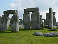 | |
|---|---|---|
| Replicas and derivatives | ||
| Studies | ||
| In culture | ||
| Concepts | ||