Sault Ste. Marie is a city in the Upper Peninsula of the U.S. state of Michigan. It is the county seat of Chippewa County and is the only city within the county. With a population of 13,337 at the 2020 census, it is the second-most populated city in the Upper Peninsula, behind Marquette. It is the primary city of the Sault Ste. Marie, MI Micropolitan Statistical Area, which encompasses all of Chippewa County and had a population of 36,785 at the 2020 census. Sault Ste. Marie was settled by mostly French colonists in 1668, making it the oldest city in Michigan.

The Ambassador Bridge is a tolled international suspension bridge across the Detroit River that connects Detroit, Michigan, United States, with Windsor, Ontario, Canada. Opened in 1929, it is the busiest international border crossing in North America in terms of trade volume, carrying more than 25% of all merchandise trade between the United States and Canada by value. A 2004 Border Transportation Partnership study showed that 150,000 jobs in the Detroit–Windsor region and US$13 billion in annual production depend on the Detroit–Windsor international border crossing.

The St. Marys River, sometimes written St. Mary's River, drains Lake Superior, starting at the end of Whitefish Bay and flowing 74.5 miles (119.9 km) southeast into Lake Huron, with a fall of 23 feet (7.0 m). For its entire length it is an international border, separating Michigan in the United States from Ontario, Canada.
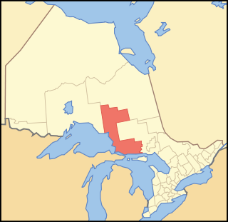
Algoma District is a district and census division in Northeastern Ontario in the Canadian province of Ontario.

U.S. Route 2 or U.S. Highway 2 (US 2) is an east–west United States Numbered Highway spanning 2,571 miles (4,138 km) across the northern continental United States. US 2 consists of two segments connected by various roadways in southern Canada. Unlike some routes, which are disconnected into segments because of encroaching Interstate Highways, the two portions of US 2 were designed to be separate in the original 1926 highway plan.
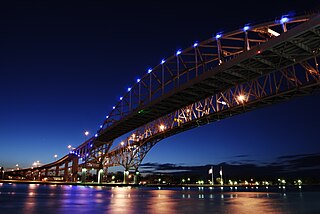
The Blue Water Bridge is a twin-span international bridge across the St. Clair River that links Port Huron, Michigan, United States, and Sarnia, Ontario, Canada. The Blue Water Bridge connects Highway 402 in Ontario with both Interstate 69 (I-69) and Interstate 94 (I-94) in Michigan.
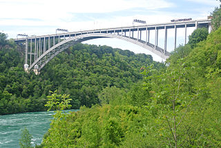
The Lewiston–Queenston Bridge, also known as the Queenston–Lewiston Bridge, is an arch bridge that crosses the Niagara River gorge just south of the Niagara Escarpment. The bridge was officially opened on November 1, 1962. It is an international bridge between the United States and Canada. It connects Interstate 190 in the town of Lewiston, New York to Highway 405 in the community of Queenston, Ontario. The Lewiston–Queenston Bridge is a twin of the Rainbow Bridge at Niagara Falls and designed by Richard Lee.
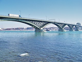
The Peace Bridge is an international bridge between Canada and the United States at the east end of Lake Erie at the source of the Niagara River, about 20 kilometres (12.4 mi) upriver of Niagara Falls. It connects Buffalo, New York, in the United States to Fort Erie, Ontario, in Canada. It is operated and maintained by the binational Buffalo and Fort Erie Public Bridge Authority.

Interstate 75 (I-75) is a part of the Interstate Highway System that runs north–south from Miami, Florida, to Sault Ste. Marie in the Upper Peninsula of the US state of Michigan. I-75 enters the state from Ohio in the south, north of Toledo, and runs generally northward through Detroit, Pontiac and Bay City, crosses the Mackinac Bridge, and ends at the Canadian border in Sault Ste. Marie. The freeway runs for approximately 396 miles (637 km) on both of Michigan's major peninsulas. The landscapes traversed by I-75 include Southern Michigan farmland, northern forests, suburban bedroom communities, and the urban core of Detroit. The freeway also uses three of the state's monumental bridges to cross major bodies of water. There are four auxiliary Interstates in the state related to I-75, as well as nine current or former business routes, with either Business Loop I-75 or Business Spur I-75 designations.

Sault Ste. Marie Transit Services is a local public transportation service serving the city of Sault Ste. Marie, Ontario providing seven major bus routes and two community bus routes serviced by a fleet of 27 buses and 2 minibuses. The Parabus service consists of 11 vehicles.
US Highway 2 (US 2) is a component of the United States Numbered Highway System that connects Everett, Washington, to the Upper Peninsula (UP) of the US state of Michigan, with a separate segment that runs from Rouses Point, New York, to Houlton, Maine. In Michigan, the highway runs through the UP in two segments as a part of the state trunkline highway system, entering the state at Ironwood and ending at St. Ignace; in between, US 2 briefly traverses the state of Wisconsin. As one of the major transportation arteries in the UP, US 2 is a major conduit for traffic through the state and neighboring northern Midwest states. Two sections of the roadway are included as part of the Great Lakes Circle Tours, and other segments are listed as state-designated Pure Michigan Byways. There are several memorial highway designations and historic bridges along US 2 that date to the 1910s and 1920s. The highway runs through rural sections of the UP, passing through two national and two state forests in the process.

The Great Lakes Circle Tour is a designated scenic road system connecting all of the Great Lakes and the St. Lawrence River. It consists of routes for circumnavigating the lakes, either individually or collectively. It was designated by the Great Lakes Commission in 1988.

Sault Ste. Marie Bridge Company is a subsidiary of the Wisconsin Central Ltd. It operates a railroad bridge over the St. Marys River between Sault Ste. Marie, Michigan and Sault Ste. Marie, Ontario.
The Sault Ste. Marie Railroad Bridge was originally built in 1887 to facilitate rail traffic crossing St. Marys River and the international border between Sault Ste. Marie, Michigan and Sault Ste. Marie, Ontario. It runs parallel to the Sault Ste. Marie International Bridge. It has nine Camelback spans and carries a single line of track.

International Bridge Walk is an annual event held on the last Saturday in June where participants can walk from Sault Ste. Marie, Michigan, to Sault Ste. Marie, Ontario, via the International Bridge. Begun in 1987, it represents the friendship between the two Saults and both countries, and is held in conjunction with Canada's national holiday, Canada Day.

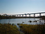
Sault Ste. Marie is a city in Ontario, Canada. The third-largest city in Northern Ontario after Sudbury and Thunder Bay, it is located on the St. Mary's River on the Canada–US border. To the southwest, across the river, is the United States and the Michigan city of the same name. The two cities are joined by the Sault Ste. Marie International Bridge, which connects Interstate 75 on the Michigan side and Huron Street on the Ontario side. Shipping traffic in the Great Lakes system bypasses the Saint Mary's Rapids via the American Soo Locks, the world's busiest canal in terms of tonnage that passes through it, while smaller recreational and tour boats use the Canadian Sault Ste. Marie Canal.

Due to its unique geography, being made of two peninsulas surrounded by the Great Lakes, Michigan has depended on many ferries for connections to transport people, vehicles and trade. The most famous modern ferries are those which carry people and goods across the Straits of Mackinac to the car-free Mackinac Island but before the Mackinac Bridge was built, large numbers of ferries carried people and cars between the two peninsulas. Other ferries continue to provide transportation to small islands and across the Detroit River to Canada. Ferries once provided transport to island parks for city dwellers. The state's only national park, Isle Royale cannot be reached by road and is normally accessed by ferry. The largest ferries in Michigan are the car ferries which cross Lake Michigan to Wisconsin. One of these, the SS Badger is one of the last remaining coal steamers on the Great Lakes and serves as a section of US Highway 10 (US 10). The Badger is also the largest ferry in Michigan, capable of carrying 600 passengers and 180 autos.
James Lloyd McIntyre was the 17th mayor of the city of Sault Ste. Marie, Ontario. During his three terms from 1960 to 1964, he helped lead a period of transition for the city, including securing the location and construction of the Sault Ste. Marie International Bridge, de-industrialization of the downtown waterfront, waste water treatment, and amalgamation of Korah and Tarentorus townships into the city.

The Sault Sainte Marie Border Crossing connects the cities of Sault Ste. Marie, Michigan, and Sault Ste. Marie, Ontario. It is located at the St. Marys River and the Sault Ste. Marie International Bridge. The U.S. Port of Entry was established in 1843 as the cities on each shore of the river grew. Regular ferry service began in 1865, and border inspection services in both the US and Canada were provided at the ferry terminals since the early 1900s. Ferry service ended in 1962 when the International Bridge spanning the river was completed. The adjacent Sault Ste. Marie International Railroad Bridge was built in 1887.