Schwarza (Leitha)

Last updated
Schwarza
Hoellental1.jpg
The Schwarza in the Höllental
Schwarza karte.jpg
Map of the Schwarza in southern Lower Austria
Location
Country Austria
State Lower Austria
Region Industrieviertel
Physical characteristics
Source 
  location Gutenstein Alps
  coordinates 47°52′17″N15°37′23″E / 47.8714°N 15.6231°E / 47.8714; 15.6231
  elevation833  m (AA)
Mouth  
  location
Discharges jointly with the River Pitten into the Leitha at Haderswörth
  coordinates
47°44′6.56″N16°13′28.72″E / 47.7351556°N 16.2246444°E / 47.7351556; 16.2246444
  elevation
302  m (AA)
Length47.7 km (29.6 mi) [1]
Basin features
Progression LeithaDanubeBlack Sea
Landmarks

The Schwarza is a river in Lower Austria. It is the left headstream of the Leitha.

Contents

Course

The Schwarza originates in the Tiefental valley at the confuence of Grüne Schwarza (German: Green Schwarza) and Dürre Schwarza (German: Dry Schwarza) in the Gutenstein Alps. The Schwarza then flows through Höllental (German: Hell Valley) gorge and the Schwarza valley. Near Haderswörth in the parish of Lanzenkirchen the Schwarza combines with the Pitten and is then called the Leitha. It is 48 kilometres (30 mi) long. Its basin area is 718 km2 (277 sq mi). [2] The Schwarza is part of the Natura 2000 region known as "North Eastern Border Alps: Hohe Wand – Schneeberg – Rax" (Nordöstliche Randalpen: Hohe Wand - Schneeberg - Rax).

Character

The Schwarza is characterized in its upper reaches by undercuts, high cliffs, gravel banks, pools and deep gullies. The lower reaches below Hirschwang an der Rax are strictly regulated as far as Schwarzau am Steinfeld. Only between Schwarzau am Steinfeld and Bad Erlach can the Schwarza spread out into wide meanders again. From Loipersbach the Schwarza runs along a sinkage section (Versickerungsstrecke), where the bulk of the water seeps into the gravel surface of the Steinfeld  [ bar; cs; de; sh ].

The river bed below the so-called "Dunkelstein Weir" in the municipality of Ternitz usually only carries water at times of snowmelt and during heavy rain. The water flows through several works channels through the town of Neunkirchen. Here it powers some small hydro plants.

At the Peisching Weir most of the water from the River Schwarza (maximum 7,000 litres per second (250 cu ft/s)) is fed into the Kehrbach  [ ceb; de; sv ] canal, which, in turn, feeds the Wiener Neustadt Canal.

During heavy rainfall, snowmelt and storms, the Schwarza quickly swells into a raging torrent.


Economic and transportation importance

Initially, the river was economically important for the timber industry. From 1803 wood from the forests on both sides of Schwarza was floated down the Schwarza and the Kehrbach to Wiener Neustadt and then loaded onto barges and transported to Vienna on the Wiener Neustadt Canal.

In earlier times, it was turned into charcoal in large kilns near the Wind Bridge. From the beginning to the middle of the 19th century numerous factories, especially paper mills, were established in the region.

The Schwarza is also used to generate electricity. For this purpose several works channels were built along the Schwarza, through which through most of the waters of the Schwarza now flow.

Of the once important paper mills, today only the company of Mayr-Melnhof Karton (MM Karton) in Hirschwang is still in operation. Numerous factory closures affected the working and social life of the region. For example, after the closure of the paper mill in Schlöglmühl, a television documentary was produced called Postadresse 2640 Schlöglmühl ("Postal Address 2640 Schlöglmühl") which portrayed the decline of the former paper industry.

The Höllental Road (B 27) follows the Schwarza valley throughout the upper parts of the river.

Water from the catchment area of the Schwarza has been used to supply drinking water to Vienna, since the 1st Viennese Spring Water Supply Network (1. Wiener Hochquellenwasserleitung) was built in 1869–1873.

Natural region

Typical animal species for the Schwarza are the: otter, grey wagtail, grey heron, wallcreeper, white-throated dipper, grayling, brown trout and bullhead.

In the vicinity of the Schwarza near Kaiserbrunn  [ de ] (belongs to Reichenau an der Rax), it was switched from the conventional restocking of fish to supporting a natural supply of fishing stock. In particular, the stock of domestic brown trout is supported by "cocooning" and "artificial nests". The goal of this project is to build a native fish stock, capable of sustaining itself. In particular, the use of "artificial nests" (spawning beds are directly injected into the substrate) supports the natural supply of brown trout.

Related Research Articles

<span class="mw-page-title-main">Lower Austria</span> State of Austria

Lower Austria is one of the nine states of Austria, located in the northeastern corner of the country. Since 1986, the capital of Lower Austria has been Sankt Pölten, replacing Vienna, which became a separate state in 1921. With a land area of 19,186 km2 (7,408 sq mi) and a population of 1.685 million people, Lower Austria is the second-most-populous state in Austria. Other large cities are Amstetten, Klosterneuburg, Krems an der Donau, Stockerau and Wiener Neustadt.

The Otselic River (aht-SEEL-ik), formerly known as Otselic Creek, is a 55.4-mile-long (89.2 km) tributary of the Tioughnioga River in central New York in the United States. It drains a hilly area, mostly forested and agricultural, east of the Finger Lakes at the northern edge of the Susquehanna River watershed.

<span class="mw-page-title-main">Leitha</span> River in Austria and Hungary

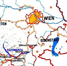
The Leitha is a river in Austria and Hungary, a right tributary of the Danube. It is 120.8 km (75.1 mi) long. Its basin area is 2,138 km2 (825 sq mi).

<span class="mw-page-title-main">Lanzenkirchen</span> Place in Lower Austria, Austria

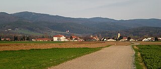
Lanzenkirchen is a market town in the district of Wiener Neustadt-Land in the Austrian state of Lower Austria.

<span class="mw-page-title-main">Rax</span> Mountain in the Northern Limestone Alps in Austria

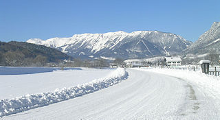
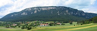
The Rax is a mountain range in the Northern Limestone Alps on the border of the Austrian federal provinces of Lower Austria and Styria. Its highest peak is the Heukuppe. The Rax, together with the nearby Schneeberg, are a traditional mountaineering and mountain walking area, and are called the Wiener Hausberge. They are separated by the deep Höllental.

<span class="mw-page-title-main">Reichenau an der Rax</span> Place in Lower Austria, Austria

Reichenau an der Rax is a market town in the Austrian state of Lower Austria, situated at the foot of the Rax mountain range on the Schwarza river, a headstream of the Leitha.

Bezirk Neunkirchen is a district of the state of Lower Austria in Austria. It is located at the south of the state.

<span class="mw-page-title-main">Neunkirchen, Austria</span> City in Lower Austria, Austria

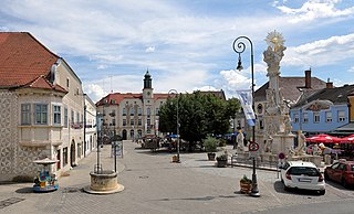
Neunkirchen is the capital of the district of Neunkirchen in the Austrian state of Lower Austria. As of 2020 it has a population of 12,721.

<span class="mw-page-title-main">Winzendorf-Muthmannsdorf</span> Place in Lower Austria, Austria

The market town of Winzendorf-Muthmannsdorf is an Austrian municipality in the district of Wiener Neustadt-Land in Lower Austria. It is situated some 64 km south of Vienna at the edge of the Southern Viennese Basin.

<span class="mw-page-title-main">Gutenstein Alps</span>

The Gutenstein Alps are a mountain range in the Eastern Alps in Central Europe, and the northeasternmost part of the Northern Limestone Alps, reaching heights over 1,000 m.

<span class="mw-page-title-main">Rax-Schneeberg Group</span>

The Rax-Schneeberg Group is a mountain range in the Northern Limestone Alps on the Styrian-Lower Austrian border in Austria.

<span class="mw-page-title-main">Unterberg (Lower Austria)</span>

The Unterberg is a prominent summit, 1,342 m above sea level (AA) high, in the Gutenstein Alps in southern Lower Austria. It is located about 10 km south of Hainfeld and is the westernmost and highest summit of a loose chain of mountains that include the Hocheck (1,037 m) and the Kieneck (1,106 m). Its crest continues towards the southwest, albeit less high, to the Brunntaler Höhe (1,090 m) and the Leitermauern (1,025 m).

<span class="mw-page-title-main">Hohe Wand (mountain)</span>

The Hohe Wand is a mountain ridge in Lower Austria and is part of the Gutenstein Alps. It lies west of Steinfeld in the Vienna Basin; its highest peak attains a height of 1,132 m. It is one of Vienna's Hausberge.

<span class="mw-page-title-main">Höllental (Lower Austria)</span>

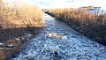
The Höllental in Lower Austria is a narrow valley between the steep limestone massifs of the Schneeberg and Rax through which the River Schwarza flows.

<span class="mw-page-title-main">Mürzsteg Alps</span>

The Mürzsteg Alps or Mürztal Alps are a mountain range in the Eastern Alps, which lie in the Austrian state of Styria, with a small part of the range in Lower Austria. The highest peak is the Hohe Veitsch in the centre of the group, while largest massif is the Schneealpe in the northwest, near the Rax.

<span class="mw-page-title-main">Prealps East of the Mur</span>

The Prealps East of the Mur are the easternmost mountain range of the Central Eastern Alps. They comprise the eastern foothills of the Alpine crest beyond the Mur river and the adjacent southeastern Alpine Foreland.

The Styrian-Lower Austrian Limestone Alps are the easternmost part of the Northern Limestone Alps, running from the River Enns to the Vienna Basin. The high Alpine, limestone massifs of the Hochschwab, Veitsch, Schneealpe, Rax and Schneeberg belong to it as do the limestone prealps to the north as far as the Flysch zone.

<span class="mw-page-title-main">First Vienna Mountain Spring Pipeline</span>

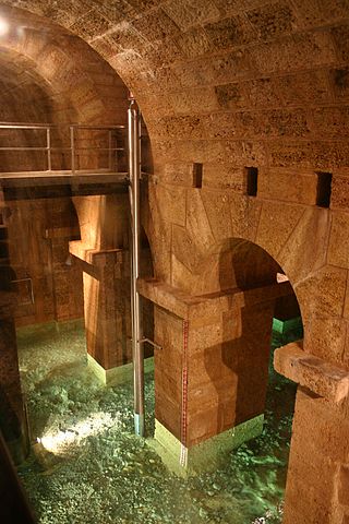
The First Vienna Mountain Spring Pipeline is a major part of Vienna's water supply and was the first source of safe drinking water for that city. The 95 km long line was opened on 24 October 1873, after four years of construction. Today, it delivers 62 million cubic meters of water per year. The water comes from high springs in the Rax and Schneeberg areas in Southern Lower Austria and Styria.

<span class="mw-page-title-main">Vienna Hausberge</span> Austrian mountains

Vienna's Hausberge are the mountains of Raxalpe, Schneeberg and Hohe Wand in the south of the state of Lower Austria. These mountains may be reached from Vienna in about an hour and are therefore a popular recreation area for the Viennese.

<span class="mw-page-title-main">Water supply in Vienna</span> Water supply in vienna is ensured by two pipelines

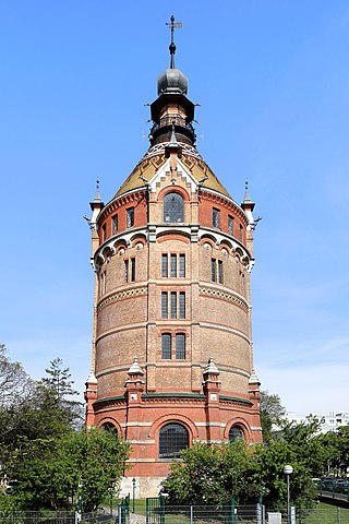
Water supply in Vienna is ensured by two high-source pipelines as well as various groundwater sources that are integrated into the pipeline system in exceptional cases. In total, up to 589,000 m³ of drinking water can thus be piped into the Austrian capital every day.

References

  1. Niederösterreich Atlas (Lower Austria)
  2. "Flächenverzeichnis der Flussgebiete: Leitha-, Rabnitz- und Raabgebiet" (PDF). Beiträge zur Hydrografie Österreichs Heft 63. December 2014. p. 21.