Scofield, Utah

Last updated

Scofield, Utah
Scofield School.jpg
Historic Scofield Utah School building
Carbon County Utah incorporated and unincorporated areas Scofield highlighted.svg
Location in Carbon County and the state of Utah
Map of USA UT.svg
Location of Utah in the United States
Coordinates: 39°43′36″N111°9′37″W / 39.72667°N 111.16028°W / 39.72667; -111.16028
Country Flag of the United States.svg  United States
State Flag of Utah.svg  Utah
County Carbon
Founded1879
Named for Mathew B. Scofield
Area
[1]
  Total0.92 sq mi (2.39 km2)
  Land0.92 sq mi (2.39 km2)
  Water0.00 sq mi (0.00 km2)
Elevation
[2]
7,733 ft (2,357 m)
Population
 (2010)
  Total22
  Estimate 
(2019) [3]
23
  Density24.95/sq mi (9.64/km2)
Time zone UTC-7 (Mountain (MST))
  Summer (DST) UTC-6 (MDT)
ZIP code
84526
Area code 435
FIPS code 49-67990 [4]
GNIS feature ID2413267 [2]
Website www.utah.com/stateparks/scofield.htm

Scofield is a town in Carbon County, Utah, United States. The population was 23 at the 2010 census. [5] Scofield's name is frequently applied to the 1900 mine disaster in the Pleasant Valley Coal Company's Winter Quarters mine. The community was named for General Charles W. Scofield, a timber contractor and local mine official. It is the smallest incorporated area in Utah by population.

Contents

History

Scofield Cemetery and some of its wooden grave markers Scofield Cemetery.jpg
Scofield Cemetery and some of its wooden grave markers

The town of Scofield is situated on high ground two miles south of the reservoir of the same name, the oldest and largest of the major impoundments on the Wasatch Plateau. Once the most populous community in Carbon County, Scofield has shrunk to only a few permanent residents. What has slowed the continual decline has become outsiders constructing summer vacation homes. The old brick school stands empty at the upper end of town, and there are abandoned buildings scattered through what was once the business district. Only the cemetery on a hill to the east suggests that this was once a community of some size. Visitors to the cemetery quickly become aware of the diverse ethnicity that populated the town. [6]

Settlement

Due to the luxuriant growth of the native grasses indigenous to this region, this valley was first utilized as pastures for the immense herds of cattle that came from Utah Valley. Among the first settlers of this region were S. J. Harkness, T. H. Thomas, William Burrows, O. G. Kimball, D. D. Green, A. H. Earll, R. McKecheney, who were attracted by the immense ranges for their cattle. [7]

Discovery of coal and coming of the railroad

Coal was discovered in the valley in 1875, and two years later a small mine was opened on the western slopes of the canyon, with the coal transported out along narrow roads. The winter of 1877 came early and was very severe, stranding the miners in the coal pit and keeping them snowbound until the following February. The ordeal led the miners to name their forced camp "Winter Quarters". It became one of the first commercial coal mines in the state. Most of the first miners at the Winter Quarters were Mormon converts from the coal districts of Wales, England and Scotland. One of them, David Williams, leased the Winter Quarters Mine from the Pleasant Valley Coal Company from 1880 to 1885, operating in the dual capacity of mine manager and bishop of the local LDS ward. When the Rio Grande Western Railway acquired the coal company, they undertook the development of a new mine on Mud Creek, a mile from Winter Quarters, much to the chagrin of Williams, who protested that the new mine infringed on his lease. Because Bishop Williams controlled the Mormon miners, the Pleasant Valley Coal Company brought in Chinese laborers to work the Mud Creek mine. Soon a large contingent of Finns were recruited, along with Italian, Greek, and other Scandinavian workers. [6]

As coal veins commenced to be worked, it was not long before the discoverers found out that the supply seemed inexhaustible. The railway companies finding that the coal fields were of such magnitude and covered so much territory, began to survey for practicable routes to reach the coal. The route through Spanish Fork Canyon was finally decided upon, and a narrow-gauge railroad was built into Scofield. Before the railroad was completed, winter set in, and the last few miles were laid upon the ice and snow as it was impossible to find the ground due to the snow drifts. The Union Pacific Coal Company claimed all of the land on the town site, and those building a home were compelled to lease the spot of ground desired from this company. Not knowing how long they would be permitted to remain as laborers in the mines, the men did not build elaborate homes, as they knew that should the work cease, they would be compelled to sacrifice their homes. Log cabins were the order of the day, as lath and plaster was out of reach on account of high prices. The Union Pacific still continued to collect their ground rent, and the knowledge that the miners had of the company that was ruling the camp at that time deterred them from beautifying their homes as they desired.

Scofield Utah's historic jail Scofield Jail.jpg
Scofield Utah's historic jail

However, this state of affairs was not to continue for long, as the rights of the company to hold the land came to be questioned. Part of their land was jumped, and their title was found to be imperfect. In fact, they had no title whatever to the land now incorporated in the townsite. The business district was more than a mile long and boasted dozens of substantial stone buildings, including an Odd Fellows Hall. [7] As the mine and the community grew, new and more efficient methods were sought to move the coal from the mines, and so the Utah & Pleasant Valley Railroad was constructed, running from Springville to Winter Quarters and Scofield. It connected with the Denver & Rio Grande line in Colton 18 miles (29 km) to the northeast. [6]

In 1882, the Utah Fuel Company took over the mine and town, and it soon became a subsidiary of the Denver & Rio Grande Railroad. The region continued to thrive until 1900, when there were several hundred men in the mines and residents that numbered as high as 1,800. The mine was considered to be the safest in the region and according to reports, was free from the gases that plagued so many other coal operations.

Coffins waiting for transport to disaster site ScofieldMineCoffins.jpg
Coffins waiting for transport to disaster site

Disaster

On May 1, 1900, an errant spark touched off the fine haze of coal dust deep underground, and the Winter Quarters #4 mine exploded with fury. Exactly 100 of the men were killed in an instant, and another 99 died from the poisonous afterdamp, making this one of the worst coal mine disasters in history. Death came so swiftly that some of the mineworkers were found still clutching their tools. That one moment of time left 105 widows and 270 fatherless children behind. Almost 150 of the slain miners were buried in the cemetery in nearby Scofield, and two special funeral trains carried the rest of the victims to burial grounds in Utah and in other states.

Decline

On May 28, just four weeks after the disaster in Number Four, coal mining resumed at Winter Quarters. While some of those who had escaped the explosion left the area for other work, many others returned to the mines. The dead were soon replaced, though production evidently suffered somewhat from the loss of more experienced miners. Despite declining profitability, the Winter Quarters mines continued to operate until the 1930s. The coal tipple and other large structures were dismantled for their salvage value during World War II; the chapel and the boarding house were leveled. [6]

Scofield, sustained by several mines in Pleasant Valley, was still the largest town in Carbon County in 1915, when its citizens made an attempt to have the county seat moved to their community from Price. By the 1920s, however, the coal industry in Pleasant Valley was clearly in decline and most mines ceased operation causing the town to lose nearly all its residents.

Geography

The town of Scofield lies in the bituminous coal field of Carbon County, Utah, about 19 miles (31 km) from the main line of the Rio Grande Western Railroad, and is nestled among the hills that surround the upper part of Pleasant Valley. The town is situated along Mud Creek, just south (upstream) of the Scofield Reservoir. The outlet of the reservoir is the Price River, which flows southeast to the Green River and is thus part of the Colorado River basin.

According to the United States Census Bureau, Scofield has a total area of 0.69 square miles (1.8 km2), all land. [5]

Utah State Route 96 passes through Scofield, leading north then east 17 miles (27 km) to U.S. Route 6 near Colton, and south 6 miles (9.7 km) to its end at Clear Creek.

Climate

Scofield has an alpine subarctic climate (Köppen Dfc) with enormous yearly snowfall in its long, cold winters due to its location in the Wasatch Range. Summertime on the other hand is pleasant, with warm days and crisp, cool nights hovering not too far above freezing.

Climate data for Scofield, Utah (Skyline Mine), 1991–2020 normals, extremes 1893–present
MonthJanFebMarAprMayJunJulAugSepOctNovDecYear
Record high °F (°C)56
(13)
56
(13)
67
(19)
74
(23)
88
(31)
91
(33)
98
(37)
94
(34)
84
(29)
75
(24)
67
(19)
59
(15)
98
(37)
Mean maximum °F (°C)45.8
(7.7)
46.0
(7.8)
53.3
(11.8)
62.0
(16.7)
71.3
(21.8)
79.9
(26.6)
84.0
(28.9)
81.5
(27.5)
76.9
(24.9)
67.4
(19.7)
55.7
(13.2)
46.4
(8.0)
84.6
(29.2)
Average high °F (°C)30.4
(−0.9)
30.9
(−0.6)
37.7
(3.2)
43.7
(6.5)
54.4
(12.4)
66.4
(19.1)
73.9
(23.3)
71.7
(22.1)
63.2
(17.3)
50.1
(10.1)
37.7
(3.2)
29.8
(−1.2)
49.2
(9.5)
Daily mean °F (°C)21.8
(−5.7)
22.5
(−5.3)
28.6
(−1.9)
34.1
(1.2)
43.5
(6.4)
53.4
(11.9)
60.8
(16.0)
59.0
(15.0)
51.0
(10.6)
39.7
(4.3)
28.5
(−1.9)
21.1
(−6.1)
38.7
(3.7)
Average low °F (°C)13.1
(−10.5)
14.0
(−10.0)
19.5
(−6.9)
24.4
(−4.2)
32.6
(0.3)
40.5
(4.7)
47.8
(8.8)
46.4
(8.0)
38.8
(3.8)
29.3
(−1.5)
19.3
(−7.1)
12.4
(−10.9)
28.2
(−2.1)
Mean minimum °F (°C)−5.1
(−20.6)
−4.7
(−20.4)
3.1
(−16.1)
9.8
(−12.3)
18.4
(−7.6)
27.4
(−2.6)
38.6
(3.7)
37.3
(2.9)
24.7
(−4.1)
13.5
(−10.3)
−0.4
(−18.0)
−6.4
(−21.3)
−10.4
(−23.6)
Record low °F (°C)−41
(−41)
−38
(−39)
−27
(−33)
−12
(−24)
9
(−13)
14
(−10)
24
(−4)
22
(−6)
12
(−11)
−9
(−23)
−25
(−32)
−37
(−38)
−41
(−41)
Average precipitation inches (mm)3.03
(77)
2.73
(69)
2.43
(62)
2.66
(68)
1.93
(49)
1.05
(27)
1.48
(38)
1.62
(41)
1.89
(48)
1.94
(49)
2.31
(59)
2.91
(74)
25.98
(661)
Average snowfall inches (cm)42.5
(108)
40.7
(103)
29.6
(75)
24.5
(62)
7.2
(18)
0.5
(1.3)
0.0
(0.0)
0.1
(0.25)
0.6
(1.5)
8.0
(20)
28.9
(73)
42.8
(109)
225.4
(571.05)
Average extreme snow depth inches (cm)30.7
(78)
28.5
(72)
20.0
(51)
9.3
(24)
3.7
(9.4)
0.4
(1.0)
0.0
(0.0)
0.0
(0.0)
0.4
(1.0)
4.7
(12)
15.1
(38)
23.8
(60)
35.9
(91)
Average precipitation days (≥ 0.01 in)11.911.810.010.79.66.18.110.18.28.39.210.9114.9
Average snowy days (≥ 0.1 in)11.511.28.87.72.30.30.00.00.33.17.910.463.5
Source 1: NOAA [8]
Source 2: National Weather Service [9]

Demographics

Historical population
CensusPop.Note
1890 680
1900 642−5.6%
1910 74616.2%
1920 678−9.1%
1930 295−56.5%
1940 262−11.2%
1950 236−9.9%
1960 158−33.1%
1970 71−55.1%
1980 10547.9%
1990 43−59.0%
2000 28−34.9%
2010 22−21.4%
2019 (est.)23 [3] 4.5%
U.S. Decennial Census [10]

As of the census [4] of 2000, there were 28 people, 12 households, and 9 families residing in the town. The population density was 55.9 people per square mile (21.6/km2). There were 78 housing units at an average density of 155.6 per square mile (60.2/km2). The racial makeup of the town was 100.00% White.

There were 12 households, out of which 25.0% had children under the age of 18 living with them, 66.7% were married couples living together, 8.3% had a female householder with no husband present, and 16.7% were non-families. 16.7% of all households were made up of individuals, and 8.3% had someone living alone who was 65 years of age or older. The average household size was 2.33 and the average family size was 2.50.

In the town, the population was spread out, with 14.3% under the age of 18, 10.7% from 18 to 24, 25.0% from 25 to 44, 28.6% from 45 to 64, and 21.4% who were 65 years of age or older. The median age was 45 years. For every 100 females, there were 75.0 males. For every 100 females age 18 and over, there were 100.0 males.

The median income for a household in the town was $26,250, and the median income for a family was $28,750. Males had a median income of $26,250 versus $14,375 for females. The per capita income for the town was $10,764. There were no families and 9.1% of the population living below the poverty line, including no under eighteens and none of those over 64.

Scofield State Park

The Scofield Reservoir Dam, Utah Scofield.jpg
The Scofield Reservoir Dam, Utah

Scofield State Park surrounds Scofield Reservoir and has three different camping areas: Mountain View, Madsen Bay, and Lake Side. Mountain View is a 34-unit campground that includes restrooms, heated showers, fish cleaning and disposal stations, a group use pavilion, a boat launching ramp, and rental boats. Madsen Bay is a 40-unit campground with restrooms, fish cleaning and disposal areas, a boat ramp, and parking for day use. Lake Side has no camping areas and is strictly day use, offering restrooms, a group use pavilion and a fishing platform for the disabled.

Clear Creek Camp

Clear Creek Camp is an outdoor education center located 2 miles (3 km) south of the town of Scofield, for post-fifth grade students in the Alpine School District. Each summer, Clear Creek Camp hosts approximately 1,100 students. The summer camp experience is designed to educate students about the outdoors and help foster a deep appreciation for the abundant natural resources and beauty in their surroundings. The camp has its roots in an outdoor education program held at Central Elementary School in the 1940s. Between 1940 and the 1960s, the program eventually grew to be so successful that a summer camp was requested. It was held at various locations for many years, including the town of Clear Creek for which it is named. After being there for a few years, property became available from Questar (then Mountain Fuel) with six cabins and a multi-purpose facility in 1973. The facilities were ready to use for groups of students in 1974, and Alpine School District has used the same grounds since then.

See also

Related Research Articles

<span class="mw-page-title-main">Carbon County, Utah</span> County in the United States

Carbon County is a county in the U.S. state of Utah. As of the 2020 United States Census, the population was 20,412. Its county seat and largest city is Price.

<span class="mw-page-title-main">Emery County, Utah</span> County in Utah, United States

Emery County is a county in east-central Utah, United States. As of the 2020 United States Census, the population was 9,825. Its county seat is Castle Dale, and the largest city is Huntington.

<span class="mw-page-title-main">Carbon, Iowa</span> City in Iowa, United States

Carbon is a city in Douglas Township, Adams County, Iowa, United States. The population was 36 at the 2020 census.

<span class="mw-page-title-main">Bearcreek, Montana</span> Incorporated town in Montana, United States

Bearcreek is an incorporated town in Carbon County, Montana, United States. It is part of the Billings, Montana Metropolitan Statistical Area. The population was 91 at the 2020 census. Bearcreek uses the Mayor/Council form of government.

<span class="mw-page-title-main">Beaver Meadows, Pennsylvania</span> Borough in Pennsylvania, United States

Beaver Meadows is a borough in Carbon County, Pennsylvania, United States. It is part of Northeastern Pennsylvania. The population was 897 at the 2020 U.S. census.

<span class="mw-page-title-main">Coaldale, Schuylkill County, Pennsylvania</span> Borough in Pennsylvania, United States

Coaldale is a borough in Schuylkill County, Pennsylvania, United States. Initially settled in 1827, it was incorporated in 1906 from part of the former Rahn Township; it is named for the coal industry—wherein, it was one of the principal early mining centers. Coaldale is in the southern Anthracite Coal region in the Panther Creek Valley, a tributary of the Little Schuylkill River, along which U.S. Route 209 was eventually built between the steep climb up Pisgah Mountain from Nesquehoning (easterly) and its outlet in Tamaqua, approximately five miles to the west.

<span class="mw-page-title-main">Helper, Utah</span> City in Utah, United States

Helper is a city in Carbon County, Utah, United States, approximately 110 miles (180 km) southeast of Salt Lake City and 7 miles (11 km) northwest of the city of Price. The population was 2,201 at the 2010 census.

<span class="mw-page-title-main">Sunnyside, Utah</span> Former city in Utah, United States

Sunnyside is a former city in Carbon County, Utah, United States. The population was 377 at the 2010 census. On January 1, 2014, the city merged with the neighboring city of East Carbon.

<span class="mw-page-title-main">Huntington, Utah</span> City in Utah, United States

Huntington is a city in northwestern Emery County, Utah, United States. The population was 2,129 at the 2010 census. It is the largest town in Emery County.

<span class="mw-page-title-main">Wales, Utah</span> Town in Sanpete County, Utah, United States

Wales is a town in Sanpete County, Utah, United States. The population was 219 at the 2000 census. The town is governed by a mayor and several council members. As of December 2008, Wales had no stores, gas stations nor stop lights. It does have a park, fire station, library and cemetery.

<span class="mw-page-title-main">Carbonado, Washington</span> Town in Washington, United States

Carbonado is a town in Pierce County, Washington, United States. It is located near the Carbon River in the north of the county, approximately 50 miles (80 km) southeast of Seattle. Carbonado is the last town before entering Mount Rainier National Park and is also a popular spot for off-roading. The town also served as an important coal mining community in the late nineteenth and early twentieth centuries, when the town operated the largest coal mine in Pierce County. The population was 734 at the 2020 census.

<span class="mw-page-title-main">Price River</span> River in Utah, United States

The Price River is a 137-mile-long (220 km) southeastward flowing river in Carbon, Utah and Emery counties in eastern Utah. It is a tributary to the Green River, itself a tributary to the Colorado River.

<span class="mw-page-title-main">Castle Gate, Utah</span> Ghost town in Utah, United States

Castle Gate is a ghost town in the western United States, located in Carbon County in eastern Utah. A mining town approximately ninety miles (140 km) southeast of Salt Lake City, its name was derived from a rock formation near the mouth of Price Canyon. This formation features two sheer sandstone walls on either side of the Price River, which appear to open like a giant gate as travelers approach this narrow section of the canyon.

<span class="mw-page-title-main">Tucker, Utah</span> Ghost town in Utah, United States

Tucker is a ghost town located near the east end of the Spanish Fork River in Utah County, Utah, United States 7 miles (11 km) below Soldier Summit on U.S. Route 6. It was once an important loading point and construction camp on the Denver and Rio Grande Western Railroad (D&RGW). After the town was abandoned, the state of Utah used the town site for a rest area. In 2009, the site was buried as part of a project to re-align a portion of US-6's western approach to Soldier Summit. To honor the town, the state of Utah built a replacement rest area about 2 miles (3.2 km) downstream from Tucker, called the Tie Fork Rest Area.

<span class="mw-page-title-main">Colton, Utah</span> Ghost town in Utah, United States

Colton is a ghost town located near the southeastern edge of Utah County, Utah, United States, approximately 6 miles (9.7 km) south of Soldier Summit. Formerly a busy railroad junction on the Denver and Rio Grande Western Railroad, Colton is a landmark on U.S. Route 6 between the cities of Spanish Fork and Price.

<span class="mw-page-title-main">Sego, Utah</span> Ghost town in Utah, United States

Sego is a ghost town in Grand County, Utah, United States. It lies in the narrow, winding Sego Canyon, in the Book Cliffs some 5 miles (8.0 km) north of Thompson Springs. Formerly an important eastern Utah coal mining town, Sego was inhabited about 1910–1955. The town is accessed via the grade of the Ballard & Thompson Railroad, a spur from the Denver and Rio Grande Western built by the founders of the town to transport the coal.

<span class="mw-page-title-main">Scofield Reservoir</span> Reservoir in the state of Utah, United States

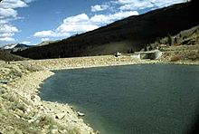
Scofield Reservoir is a 2,815-acre (11.39 km2) reservoir impounded by Scofield Dam, in Carbon County, Utah. Located on the Price River, a tributary of the Green River, Scofield Reservoir is adjacent to the northernmost boundary of the Manti–La Sal National Forest. The reservoir sits at an elevation of 7,618 feet (2,322 m), on the northern edge of the Wasatch Plateau. Utah State Route 96 runs along the western shoreline.

<span class="mw-page-title-main">Clear Creek, Utah</span> Census-designated place in Utah, United States

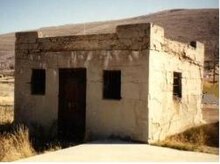
Clear Creek is a census-designated place on the western edge of Carbon County, Utah, United States. It is located at the south end of State Route 96 and the Pleasant Valley Branch of the Union Pacific Railroad.

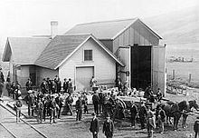
Winter Quarters is a ghost town in Carbon County, Utah, United States. Coal was discovered in the area in 1875, and later that year, the Pleasant Valley Coal Company began coal mining operations. A group of coal miners were delayed during an early winter storm in 1877, which led to the town's name of Winter Quarters. On May 1, 1900, an explosion in the Winter Quarters Number Four mine killed 200 miners. Despite the mine explosion, the coal mining operations remained active until 1922, when the opening of a new mine in Castle Gate caused many people to relocate there. By 1930, Winter Quarters was abandoned.

The Scofield Mine disaster was a mining explosion that occurred at the Winter Quarters coal mine on May 1, 1900. The mine was located at 39°42′57″N111°11′17″W near the town of Scofield, Utah. In terms of life lost, it was the worst mining accident at that point in American history. The explosion is also a key element in the plot of the Carla Kelly novel My Loving Vigil Keeping.

References

  1. "2019 U.S. Gazetteer Files". United States Census Bureau. Retrieved August 7, 2020.
  2. 1 2 U.S. Geological Survey Geographic Names Information System: Scofield, Utah
  3. 1 2 "Population and Housing Unit Estimates". United States Census Bureau. May 24, 2020. Retrieved May 27, 2020.
  4. 1 2 "U.S. Census website". United States Census Bureau . Retrieved January 31, 2008.
  5. 1 2 "Geographic Identifiers: 2010 Census Summary File 1 (G001): Scofield town, Utah". U.S. Census Bureau, American Factfinder. Archived from the original on February 13, 2020. Retrieved August 10, 2015.
  6. 1 2 3 4 Geary, Edward A. (March 12, 2002). The proper edge of the sky: the high plateau country of Utah. University of Utah Press. ISBN   0-87480-409-4.
  7. 1 2 Dilley, James W. History of the Scofield mine disaster.
  8. "U.S. Climate Normals Quick Access – Station: Scofield-Skyline Mine, UT". National Oceanic and Atmospheric Administration. Retrieved September 4, 2023.
  9. "NOAA Online Weather Data – NWS Salt Lake City". National Weather Service. Retrieved September 4, 2023.
  10. "Census of Population and Housing". Census.gov. Retrieved June 4, 2015.