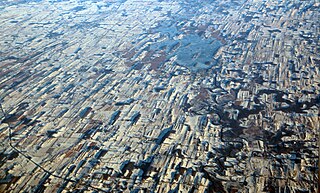
A drumlin, from the Irish word droimnín, first recorded in 1833, in the classical sense is an elongated hill in the shape of an inverted spoon or half-buried egg formed by glacial ice acting on underlying unconsolidated till or ground moraine. Assemblages of drumlins are referred to as fields or swarms; they can create a landscape which is often described as having a 'basket of eggs topography'.

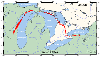
The Niagara Escarpment is a long escarpment, or cuesta, in Canada and the United States that starts from the south shore of Lake Ontario westward, circumscribes the top of the Great Lakes Basin running from New York through Ontario, Michigan, and Wisconsin. The escarpment is the cliff over which the Niagara River plunges at Niagara Falls, for which it is named.

The Oak Ridges Moraine is an ecologically important geological landform in the Mixedwood Plains of south-central Ontario, Canada. The moraine covers a geographic area of 1,900 square kilometres (730 sq mi) between Caledon and Rice Lake, near Peterborough. One of the most significant landforms in southern Ontario, the moraine gets its name from the rolling hills and river valleys extending 160 km (99 mi) east from the Niagara Escarpment to Rice Lake, formed 12,000 years ago by advancing and retreating glaciers during the last glaciation period. Below the approximately 200 metre thick glacial derived sediments of the moraine lies thick bedrock successions of Precambrian rocks and up to 200 metres of Ordovician aged rock, capped by a regional unconformity of erosion and non-deposition to the Quaternary period. Rivers and lakes scatter the landscape and are important for creating habitat for the rich diversity of species of animals, trees and shrubbery. These are also the supply of fresh water to aquifers in the moraine through complex subterranean connections. Construction development nearby, and with expansion of communities around the moraine in need of potable water, it is a contested site in Ontario, since it stands in the path of major urban development. Conservation of the moraine is thus an important step for keeping aquifers in a safe drinkable condition while also protecting the natural ecosystems surrounding and within the moraine. This region has been subject to multiple decades of scientific research to study the origins of formation, and how early communities used the land. A larger focus currently is how to source potable water without removing the aquifer entirely.

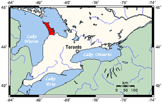
The Bruce Peninsula is a peninsula in Ontario, Canada, that divides Georgian Bay of Lake Huron from the lake's main basin. The peninsula extends roughly northwestwards from the rest of Southwestern Ontario, pointing towards Manitoulin Island, with which it forms the widest strait joining Georgian Bay to the rest of Lake Huron. The Bruce Peninsula contains part of the geological formation known as the Niagara Escarpment.

Prince Edward County (PEC) is a county in southern Ontario, Canada. Its coastline on Lake Ontario’s northeastern shore is known for Sandbanks Provincial Park, sand beaches, and limestone cliffs. The Regent Theatre, a restored Edwardian Opera House, sits at the heart of the town of Picton on the Bay of Quinte. Nearby Macaulay Heritage Park highlights local history through its 19th-century buildings. In 2016, Prince Edward County had a census population of 24,735. Prince Edward County is a city, single-tier municipality and a census division of the Canadian province of Ontario.

UTC−04:00 is an identifier for a time offset from UTC of −04:00.

Sandbanks Provincial Park is a provincial park located on Lake Ontario in Prince Edward County near Picton, Ontario, Canada. The park is considered one of the best sandy beaches in Ontario and contains the largest bay-mouth barrier dune formation in the world. The 1,550.87-hectare (3,832.3-acre) park was established in 1970 and operates year round. Birdwatching, camping, cycling, fishing, and swimming are among the activities available in the park.
Northwest Indiana, nicknamed The Region after the Calumet Region, comprises Lake, Porter, LaPorte, and Newton counties in Indiana. This region neighbors Lake Michigan and is part of the Chicago metropolitan area. According to the 2020 Census, Northwest Indiana has a population of 831,080 and is the state's second largest urban area after the Indianapolis Metropolitan Area. It is also the home of the Indiana Dunes, parts of which have been preserved through conservation efforts. The town of Ogden Dunes houses the Hour Glass, a museum showcasing the ecological and conservation efforts of O. D. Frank.

Sand Hills was an active lighthouse on the shore of Lake Superior is on private property and is currently closed to the public. It is located in Ahmeek in Keweenaw County in the Keweenaw Peninsula, which is the northern part of the Upper Peninsula in Michigan. It was listed in the National Register of Historic Places in 1994.

Mohawk Island is a small island in the northeast of Lake Erie, in Haldimand County, Ontario, Canada. It is composed of limestone with almost no vegetation, and is close to the water level. It was formerly known as Gull Island and contains the ruins of the Gull Island Lighthouse which was built in 1848 to guide ships into the Welland Canal at Port Maitland. In 1933, the lighthouse was automated to no longer require a human keeper and lost significance in 1934 due to the realignment of the canal at Port Colborne. It was decommissioned in 1969 when the mechanism was destroyed by a fire. The lighthouse is located close to the shore of Rock Point Provincial Park.
The scotch bonnet is a variety of chili pepper.

The Charity Shoal crater is a 1.2–1.4 kilometers (0.75–0.87 mi) in diameter circular feature that lies submerged beneath the northeast end of Lake Ontario about 12 kilometers (7.5 mi) southwest of Wolfe Island, and 25 kilometers (16 mi) south of Kingston, Ontario at about latitude 44° 02′ N and longitude 76° 29′ W. It is hypothesized to be a Middle Ordovician impact crater.

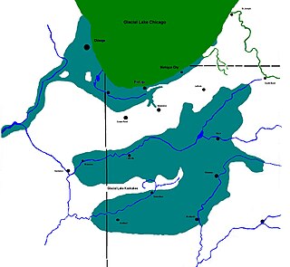
Lake Kankakee formed 14,000 years before present (YBP) in the valley of the Kankakee River. It developed from the outwash of the Michigan Lobe, Saginaw Lobe, and the Huron-Erie Lobe of the Wisconsin glaciation. These three ice sheets formed a basin across Northwestern Indiana. It was a time when the glaciers were receding, but had stopped for a thousand years in these locations. The lake drained about 13,000 YBP, until reaching the level of the Momence Ledge. The outcropping of limestone created an artificial base level, holding water throughout the upper basin, creating the Grand Kankakee Marsh.
John E. Pearce Provincial Park has been a protected area since 1957. It is located in the Carolinian forest zone of southwestern Ontario, covers 67.9 hectares on the north shore of Lake Erie in Elgin County, and is one of two protected areas in the Southwest Elgin Forest Complex subzone.

Swetman Island, formerly False Duck Island, is a small Canadian island in Lake Ontario, south of Picton, Ontario. It is the largest island in a chain of islands and shoals known as the False Duck Islands, not to be confused with the nearby Main Duck Islands. Nearby Timber Island is also considered part of the False Duck Islands. The False Duck Islands, the Main Duck Islands, and Galloo Island and Stony Island on the US side, and their associated shoals, form the Duck Galloo Ridge.

Scotch Bonnet Island is a small island in Lake Ontario. It is part of Prince Edward County, Ontario, Canada.

The Duck Galloo Ridge is a mainly underwater ridge, at the eastern end of Lake Ontario, spanning from Prince Edward County, Ontario to Jefferson County, New York. In pre-Columbian times native people used the islands on the ridge as way stations, when crossing the lake. The islands and shoals that dot the ridge have been navigational hazards since sailing ships first started navigating the lake.

Wellers Bay is a small bay on Lake Ontario, on the west side of Prince Edward County. In 1861 the Government of the Province of Canada considered making it a "harbour of refuge", and installing a lighthouse.
Nicholson Island is a small island in Lake Ontario about 3 kilometres (1.9 mi) west of Prince Edward County, Ontario. It is one of the islands and shoals in the Scotch Bonnet Ridge.


