The Jamestown settlement in the Colony of Virginia was the first permanent English settlement in the Americas. It was located on the northeast bank of the James River, about 2.5 mi (4 km) southwest of the center of modern Williamsburg. It was established by the Virginia Company of London as "James Fort" on May 4, 1607 O.S., and was considered permanent after a brief abandonment in 1610. It followed several failed attempts, including the Lost Colony of Roanoke, established in 1585 on Roanoke Island, later part of North Carolina. Jamestown served as the colonial capital from 1616 until 1699. Despite the dispatch of more settlers and supplies, including the 1608 arrival of eight Polish and German colonists and the first two European women, more than 80 percent of the colonists died in 1609–10, mostly from starvation and disease. In mid-1610, the survivors abandoned Jamestown, though they returned after meeting a resupply convoy in the James River.

York County is a county in the eastern part of the Commonwealth of Virginia, located in the Tidewater. As of the 2020 census, the population was 70,045. The county seat is the unincorporated town of Yorktown.

Williamsburg is an independent city in the Commonwealth of Virginia, United States. As of the 2020 census, it had a population of 15,425. Located on the Virginia Peninsula, Williamsburg is in the northern part of the Hampton Roads metropolitan area. It is bordered by James City County on the west and south and York County on the east.

Prince George County is a county located in the Commonwealth of Virginia. As of the 2020 census, the population was 43,010. Its county seat is Prince George.

James City County is a county located in the Commonwealth of Virginia. As of the 2020 census, the population was 78,254. Although politically separate from the county, the county seat is the adjacent independent city of Williamsburg.

Smithfield is a town in Isle of Wight County, in the South Hampton Roads subregion of the Hampton Roads region of Virginia in the United States. The population was 8,533 at the 2020 census.

Yorktown is a census-designated place (CDP) in York County, Virginia. It is the county seat of York County, one of the eight original shires formed in colonial Virginia in 1682. Yorktown's population was 195 as of the 2010 census, while York County's population was 66,134 in the 2011 census estimate.

The Virginia Peninsula is a peninsula in southeast Virginia, bounded by the York River, James River, Hampton Roads and Chesapeake Bay. It is sometimes known as the Lower Peninsula to distinguish it from two other peninsulas to the north, the Middle Peninsula and the Northern Neck.
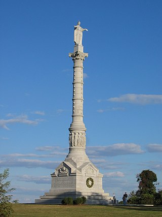
Colonial National Historical Park is a large national park located in the Hampton Roads region of Virginia operated by the National Park Service. It protects and interprets several sites relating to the Colony of Virginia and the history of the United States more broadly. These range from the site of the first English settlement at Jamestown, to the battlefields of Yorktown where the British Army was defeated in the American Revolutionary War. Over 3 million people visit the park each year.
Surry County is a county in the Commonwealth of Virginia. As of the 2020 census, the population was 6,561.

Colonial Parkway is a 23-mile (37 km) scenic parkway linking the three points of Virginia's Historic Triangle, Jamestown, Williamsburg, and Yorktown. It is part of the National Park Service's Colonial National Historical Park. Virginia's official state classification for the parkway is State Route 90003. With portions built between 1930 and 1957, it links the three communities via a roadway shielded from views of commercial development. The roadway is toll-free, is free of semi trucks, and has speed limits of around 35 to 45 mph. As a National Scenic Byway and All-American Road, it is also popular with tourists due to the James River and York River ends of the parkway.
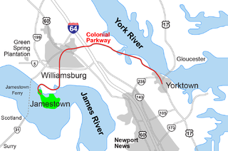
The Historic Triangle includes three historic colonial communities located on the Virginia Peninsula of the United States and is bounded by the York River on the north and the James River on the south. The points that form the triangle are Jamestown, Colonial Williamsburg, and Yorktown. They feature many restored attractions and are linked by the Colonial Parkway in James City and York counties, and the City of Williamsburg.

State Route 31 is a primary state highway in the U.S. state of Virginia. The state highway runs 24.56 miles (39.53 km) from U.S. Route 460 in Wakefield north to SR 5 and SR 199 in Williamsburg. SR 31 is the primary north–south highway of Surry County, where the highway serves the towns of Surry and Dendron. The state highway also connects Williamsburg with Jamestown. The sections of SR 31 on either side of the James River are connected by the Jamestown Ferry.
Varina Farms, also known as Varina Plantation or Varina Farms Plantation or Varina on the James, is a plantation established in the 17th century on the James River about 10 miles (16 km) south of Richmond, Virginia. An 820-acre (330 ha) property was listed on the National Register of Historic Places in 1977 as "Varina Plantation". At that time it included two contributing buildings and one other contributing site.

Transportation in the Commonwealth of Virginia is by land, sea and air. Virginia's extensive network of highways and railroads were developed and built over a period almost 400 years, beginning almost immediately after the founding of Jamestown in 1607, and often incorporating old established trails of the Native Americans.

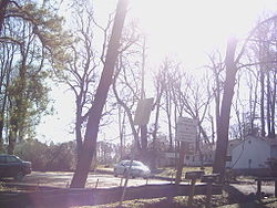
Historic Jamestown is the cultural heritage site that was the location of the 1607 James Fort and the later 17th-century town of Jamestown in America. It is located on Jamestown Island, on the James River at Jamestown, Virginia and operated as a partnership between Preservation Virginia and the U.S. National Park Service as part of Colonial National Historical Park.

The Swann's Point Plantation Site is an archaeological site near the James River in Surry County, Virginia. The Swann's Point area, located west of the mouth of Gray Creek, has a rich historic of precolonial Native American occupation, as well as significant early colonial settlements. It was first granted to Richard Pace, whose warning famously saved the Jamestown Colony during the Indian Massacre of 1622. The Paces abandoned their settlement in 1624.