
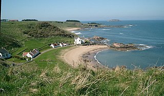
Seacliff comprises a beach, an estate and a harbour. It lies 4 miles (6 kilometres) east of North Berwick, East Lothian, Scotland.
Seacliff comprises a beach, an estate and a harbour. It lies 4 miles (6 kilometres) east of North Berwick, East Lothian, Scotland.
The beach and estate command a strategic position at the mouth of the Firth of Forth, and control of the area has been contested through the ages. The beach and estate were used as a staging post for various raids on nearby Tantallon Castle from the 14th to the 17th century. Troops were also stationed here to prevent landings by the French during the Napoleonic Wars in 1798. Before bloodshed touched the area, the 8th century Christian missionary Saint Baldred was based in nearby Scoughall, and several features of the area have been named after him, such as "Ghegan Rock" (Churchman's Haven).
In quieter times, the ownership of the estate has changed hands on several occasions. Seacliff House was built in 1750 by Robert Colt. It was later bought by George Sligo who in 1841 employed the famous Scottish architect David Bryce to build a new house in baronial style on the core of the older house. From 1854 until 1885 the house was owned by the orientalist John Watson Laidlay and he lived here with his family including Johnny Laidlay.
In 1907 the house was gutted by fire, killing the owner, Andrew Laidlay. Although plans were drawn up by Robert Lorimer for its restoration in 1911 these were never carried out. [1]
The exterior survives almost complete with gables, turrets and bartizans. The outbuildings were later purchased by the Royal Navy who established a top-secret research base there during World War I. The station, known as HMS Scottish Seacliff, was mainly used for navigation training and U-Boat defence.
Robert Louis Stevenson was related to the Dale family, who still own and farm much of the land around Seacliff today.
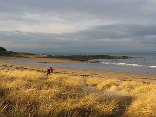
Seacliff Beach is private, and entry for cars is controlled by a coin-operated barrier. The area is largely unspoiled and attracts surfers, dog-walkers, riders and summer picnickers.
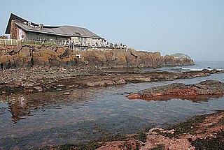
Seacliff Harbour is a sheltered spot accessible through a narrow channel, all blasted out of the red sandstone cliffs. This was constructed in 1890 by Andrew Laidlay, the then laird, who used a steam engine and compressed air to cut the stone. It was once home to boats owned by fishermen and landowners but today it is rarely used by boats and more for diving and dive training. The entrance measures just three metres across and it is the smallest harbour in the UK.
The estate is home to farming, the Seacliff Haulage depot and a small number of cottages.


East Lothian is one of the 32 council areas of Scotland, as well as a historic county, registration county and lieutenancy area. The county was also known as Haddingtonshire.

Eyemouth is a small town and civil parish in Berwickshire, in the Scottish Borders area of Scotland. It is two miles east of the main north–south A1 road and eight miles north of Berwick-upon-Tweed.
North Berwick is a seaside town and former royal burgh in East Lothian, Scotland. It is situated on the south shore of the Firth of Forth, approximately 20 miles (32 km) east-northeast of Edinburgh. North Berwick became a fashionable holiday resort in the nineteenth century because of its two sandy bays, the East Bay and the West Bay, and continues to attract holidaymakers. Golf courses at the ends of each bay are open to visitors.

The Royal Burgh of Haddington is a town in East Lothian, Scotland. It is the main administrative, cultural and geographical centre for East Lothian, which as a result of late-nineteenth century Scottish local government reforms took the form of the county of Haddingtonshire for the period from 1889 to 1921. It lies about 17 miles east of Edinburgh. The name Haddington is Anglo-Saxon, dating from the sixth or seventh century AD when the area was incorporated into the kingdom of Bernicia. The town, like the rest of the Lothian region, was ceded by King Edgar of England and became part of Scotland in the tenth century. Haddington received burghal status, one of the earliest to do so, during the reign of David I (1124–1153), giving it trading rights which encouraged its growth into a market town.

St Monans, sometimes spelt St Monance, is a village and parish in the East Neuk of Fife and is named after the legendary Saint Monan.

Gullane is a town on the southern shore of the Firth of Forth in East Lothian on the east coast of Scotland. There has been a church in the village since the ninth century. The ruins of the Old Church of St. Andrew built in the twelfth century can still be seen at the western entrance to the village; the church was abandoned after a series of sandstorms made it unusable, and Dirleton Parish Church took its place.

Dirleton is a village and civil parish in East Lothian, Scotland approximately 20 miles (32 km) east of Edinburgh on the A198. It contains 7,500 acres (30 km2). Dirleton lies between North Berwick (east), Gullane (west), Fenton Barns (south) and the Yellowcraigs nature reserve, Archerfield Estate and the Firth of Forth (north). Gullane parish was joined to Dirleton parish in 1612 by an Act of Parliament because "Golyn is ane decaying toun, and Dirleton is ane thriven place."

Auldhame and Scoughall are hamlets in East Lothian, Scotland. They are close to the town of North Berwick and the village of Whitekirk, and are approximately 25 miles (40 km) east of Edinburgh.
The Scottish Seabird Centre is a marine conservation and education charity, that is supported by a 5 star visitor attraction in North Berwick, East Lothian, Scotland. Opened by HRH Duke of Rothesay in 2000 and funded by the Millennium Commission. The showpiece of the centre is the interactive live cameras out to the wildlife on the Firth of Forth islands, including Bass Rock, Isle of May, Fidra and Craigleith. The Bass Rock is the world's largest colony of Northern gannets with an estimated 150,000 birds present.
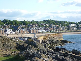
The Harbour at North Berwick in East Lothian, Scotland, was originally a ferry port for pilgrims travelling to St Andrews in Fife. Today the water is home to leisure craft, a famous tourist launch and the remains of the fishing fleet that once dominated the area, while on dry land the Scottish Seabird Centre, East Lothian Yacht Club and Auld Kirk Green are the main attractions.
Yellowcraig, less commonly known as Broad Sands Beach, is a coastal area of forest, beach and grassland in East Lothian, south-east Scotland. Yellowcraig is partly within the Firth of Forth Site of Special Scientific Interest (SSSI). It is bordered to the north by the Firth of Forth, to the south by the village of Dirleton and Dirleton Castle, to the east by the North Berwick West Links golf course, and to the west by the Archerfield Estate and Links golf courses.
Archerfield and Archerfield Links are a country house and pair of golf courses in the parish of Dirleton, East Lothian, Scotland. An older golf course, also called Archerfield Links, occupied the area before falling into disuse after World War II.
Balthere of Tyninghame was a Northumbrian hermit and abbot, resident in East Lothian during the 8th century.
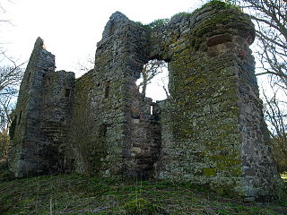
Auldhame Castle is a ruined L-plan tower house standing on a ridge above Seacliff beach, about 3 miles east of North Berwick in East Lothian, and less than half a mile from Tantallon Castle. The castle was built in the 16th century, probably by Adam Otterburn of Reidhall, Lord Provost of Edinburgh. It consists of a three-storey main block with a projecting stair-tower. Part of a vaulted basement remains, but the upper floors are mostly gone.
Whitekirk is a small settlement in East Lothian, Scotland. Together with the nearby settlement of Tyninghame, it gives its name to the parish of Whitekirk and Tyninghame.

Cove is a village in the Scottish Borders area of Scotland,18 mi (29 km) northwest of the Scotland/England border. It is about 36 miles southeast of Edinburgh and 8 mi (13 km) from Dunbar. Cove is close to Cockburnspath, Dunglass, Innerwick, Oldhamstocks, Bilsdean, and, further afield, Dunbar and Eyemouth. The climate is typical for Scotland, with cold, wet winters and variable summer weather, with days of rain and days of temperatures over 20 °C (68 °F).
Canty Bay is a small inlet and coastal hamlet on the northern coast of East Lothian, Scotland. It is 2 miles (3.2 km) east of North Berwick and is opposite the Bass Rock and Tantallon Castle. Other settlements nearby include Auldhame, Scoughall, Seacliff, and the Peffer Sands. Canty Bay means "bay of the little head" from the Gaelic ceanntan, diminutive of ceann.

John Ernest Laidlay was a Scottish amateur golfer. He invented the most popular golf grip used today, although the grip is credited to Harry Vardon, who took it up after Laidlay.

Spott is a small village on the eastern fringes of East Lothian in Scotland, just over 2 miles (3.2 km) south-west of Dunbar. The village straddles an unclassified road leading from the main A1 highway at grid reference NT673755.