
Rotenburg an der Wümme is a town in Lower Saxony, Germany. It is the capital of the district of Rotenburg.

Clausthal-Zellerfeld is a town in Lower Saxony, Germany. It is located in the southwestern part of the Harz mountains. Its population is approximately 15,000. The City is the location of the Clausthal University of Technology. The health resort is located in the Upper Harz at an altitude between 390 and 821 m above sea level.
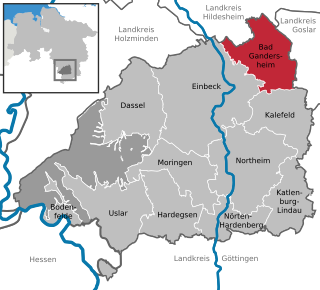
Bad Gandersheim is a town in southern Lower Saxony, Germany, located in the district of Northeim. As of December 2020, it had a population of 9,492.

Moringen is a town in the district Northeim, in the southern part of Lower Saxony, Germany. The town consists of the center Moringen and eight surrounding villages, Fredelsloh being one of them.

Braunlage is a town and health resort in the Goslar district of Lower Saxony in Germany. Situated within the Harz mountain range, south of the Brocken massif, Braunlage's main business is tourism, particularly skiing. Nearby ski resorts include the Sonnenberg and the slopes on the Wurmberg.

Holzminden is a town in southern Lower Saxony, Germany. It is the capital of the district of Holzminden. It is located on the river Weser, which at this point forms the border with the state of North Rhine-Westphalia.

Bad Fallingbostel is the district town (Kreisstadt) of the Heidekreis district in the German state of Lower Saxony. Since 1976 the town has had a state-recognised Kneipp spa and has held the title of Bad since 2002. It has close ties to Walsrode, a few miles to the west. Until 2015, there was a British Army base in Bad Fallingbostel, It also hosted Defender 2020, the largest US Army/NATO exercise since the Cold War. The town has around 11,000 inhabitants.

Meppen is a town in and the seat of the Emsland district of Lower Saxony, Germany, at the confluence of the Ems, Hase, and Nordradde rivers and the Dortmund–Ems Canal (DEK). The name stems from the word Mappe, meaning "delta".

Rehburg-Loccum is a town 50 km north west of Hanover in the district of Nienburg in Lower Saxony, Germany.

Garbsen is a town in the district of Hanover, in Lower Saxony, Germany. It is situated on the river Leine, approx. 11 km northwest of Hanover. The name Garbsen can be traced back to 1223. Today's 13 city districts have partly developed independently until the city of Garbsen was formed within its current boundaries during the regional reform in 1974.

Hambühren is a municipality in the district of Celle, in Lower Saxony, Germany. It is situated approximately 7 km (4.3 mi) west of Celle.

Winsen an der Aller or Winsen (Aller) is a town in the district of Celle in the German state of Lower Saxony.

Lehre is a municipality in the district of Helmstedt, in Lower Saxony, Germany. The current population is 11,539 and is situated approximately 13 km (8.1 mi) southwest of Wolfsburg, and 12 km (7.5 mi) Braunschweig.

Bad Grund (Harz) is a town in the district of Göttingen, in Lower Saxony, Germany. It is situated in the western Harz, approx. 7 km west of Clausthal-Zellerfeld, and 10 km north of Osterode am Harz.

Burgdorf is a town in the Hanover Region, in Lower Saxony, Germany. It is situated approximately 22 km northeast of Hanover. Until 1974, Burgdorf was the capital of the Burgdorf district. The town and its surrounding areas are known for the tradition of growing white Asparagus and for breeding Hanoverian horses. Burgdorf hosts a monthly horse market from April to September every year.

Lehrte is a town in the district of Hanover, in Lower Saxony, Germany. It is situated approximately 17 km east of Hanover. In the 19th century Lehrte was the most important railway junction in the former Kingdom of Hanover. As of the 21st century, it has a population of 43,000.
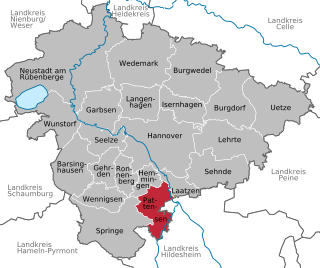
Pattensen is a town in the district of Hanover, in Lower Saxony, Germany. It is situated approximately 12 km (7 mi) south of Hanover.

Springe is a town in the district of Hanover, in Lower Saxony, Germany. It is situated near the Deister hills, 22 kilometres (14 mi) southwest of Hanover.

Adenbüttel is a municipality in the Gifhorn district in Lower Saxony, Germany. It is a member municipality of the Samtgemeinde Papenteich. The Municipality Adenbüttel includes the villages of Adenbüttel and Rolfsbüttel

Hohenfels is a municipality in the district of Neumarkt in the region of Upper Palatinate in Bavaria, Germany. The town is host to the United States Army Garrison Hohenfels, which operates the Joint Multinational Readiness Center for training NATO armed forces.


