North Yorkshire is a ceremonial county in Northern England. It borders County Durham to the north, the North Sea to the east, the East Riding of Yorkshire to the south-east, South Yorkshire to the south, West Yorkshire to the south-west, and Cumbria and Lancashire to the west.

Askham Bryan is a village and civil parish in the unitary authority area of City of York in the north of England, 6 miles (10 km) south-west of York, west of Bishopthorpe, and close to Askham Richard and Copmanthorpe. According to the 2001 census the parish had a population of 582, reducing to 564 at the 2011 census.

Askham Richard is a village and civil parish in the unitary authority of City of York in the north of England, 6.5 miles (10.5 km) south-west of York, close to Copmanthorpe, Bilbrough and Askham Bryan. The population of the civil parish at the 2011 census was 351. The village became a Conservation Area in 1975. Nearby is Askham Bryan College of Agriculture.

Copmanthorpe is a village and civil parish in the City of York in the English county of North Yorkshire, 4 miles (6.4 km) south-west of York, west of Bishopthorpe and close to Acaster Malbis, Askham Bryan and Askham Richard. According to the 2001 census the parish had a population of 4,262, reducing to 4,173 at the 2011 Census.

The Borough of Harrogate was a local government district with borough status in North Yorkshire, England. On 31 March 2023 it was abolished and on 1 April 2023 its functions were transferred to the new North Yorkshire Council.

Selby was a parliamentary constituency in North Yorkshire, represented in the House of Commons of the Parliament of the United Kingdom. It elected one Member of Parliament (MP) by the first past the post system of election. The constituency existed from 1983 to 2010.
The Ainsty or the Ainsty of York was a historic district of Yorkshire, England, west of the city of York. Originally a wapentake or subdivision of the West Riding of Yorkshire it later had a unique status as a rural area controlled by the corporation of the city.
Hemsworth was, from 1894 to 1974, a rural district in the West Riding of Yorkshire, England.
Tadcaster Rural District was a rural district in the West Riding of Yorkshire from 1894 to 1974. It was named after Tadcaster.

Kexby is a village and civil parish in the unitary authority of the City of York in North Yorkshire, England. It lies on the River Derwent and on the A1079 road about 5 miles (8 km) east of York not far from the East Riding of Yorkshire border.
Selby was a rural district in the West Riding of Yorkshire from 1894 to 1974.

Selby and Ainsty is a constituency in North Yorkshire. It has been represented by Keir Mather from the Labour Party since 21 July 2023.

Thorganby is a small village and civil parish in North Yorkshire, England. It was historically part of the East Riding of Yorkshire until 1974, but from 1974 to 2023 was in the Selby District of the shire county of North Yorkshire. In 2023 the district was abolished and North Yorkshire became a unitary authority.
The history of local government in Yorkshire is unique and complex. Yorkshire is the largest historic English county and consists of a diverse mix of urban and rural development with a heritage in agriculture, manufacturing, and mining. After a long period with little change, it has been subject to a number of reforms of local government structures in modern times, some of which were controversial. The most significant of these were the Local Government Act 1972, the 1990s UK local government reform, and the Localism Act 2011. The historic area currently corresponds to several counties and districts and is mostly contained within the Yorkshire and the Humber region.

North Yorkshire Council, known until 1 April 2023 as North Yorkshire County Council, is the unitary authority which governs the district of North Yorkshire, within the larger ceremonial county of North Yorkshire, in England. The council's headquarters is County Hall in Northallerton, the county town.
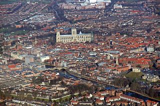
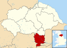
The City of York is a unitary authority area with city status in the ceremonial county of North Yorkshire, England. The district's main settlement is York, and it extends to the surrounding area including the town of Haxby and the villages of Earswick, Upper Poppleton, Nether Poppleton, Copmanthorpe, Bishopthorpe, Dunnington, Stockton on the Forest, Rufforth, Askham Bryan and Askham Richard, among other villages and hamlets. The unitary area had a population of 202,800 in the 2021 Census The City of York is administered by the City of York Council based in The Guildhall.
The City of York is a unitary authority of the United Kingdom. There are many distinct localities, suburbs and villages within the administrative area of the City. All areas in the City are in the YO postcode area, also known as the York postcode area.

Leeds, commonly known as the City of Leeds, is a metropolitan borough with city status in West Yorkshire, England. The metropolitan borough includes the administrative centre of Leeds and the towns of Farsley, Garforth, Guiseley, Horsforth, Morley, Otley, Pudsey, Rothwell, Wetherby and Yeadon. It has a population of 811,956 (2021), making it technically the second largest city in England by population behind Birmingham, since London is not a single local government entity. Local governance sits with Leeds City Council and the city's 32 Parish Councils.
Elections to the new City of York unitary authority were held on 4 May 1995, although the new unitary authority wasn't officially created until April 1996. All 53 council seats in the city were up for election and the Labour Party won overall control of the council.