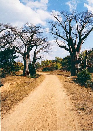
Sena railway,[1][2] also called Shire Highlands railway, Dondo-Malawi railway and North-South Malawi railway, is a railway that connects Dondo, Mozambique, to Chipata, in Zambia. It is c. 1000 km long, in a 1067 mm gauge.[3]
Initially the Sena railway had the function of connecting the Protectorate of Nyasaland (currently Malawi) from north to south, using waterways to reach seaports.
Construction
In 1901, the Shire Highlands Railway Company was formed in Blantyre by British investors. He soon obtained a concession to build a railway connecting Nsanje, on the Shire River (at the southernmost point of the protectorate), to Mangochi, at the southern end of Lake Malawi, via Chiromo and Blantyre. The first section of this line, between Nsanje and Chiromo, was opened to traffic on 1 September 1904. The contract for the construction of a branch was awarded to the British South Africa Company, connecting Chindio and Nsanje, the latter becoming an important waterway connection port with the maritime city of Beira. The irregular river flow in the region — sometimes with large and destructive floods, sometimes with severe droughts — made safe navigation almost impossible, causing this option to be discarded and the continuation of a railway line to Quelimane to be abandoned.[6]
The effective planning of what is currently the Sena railway would only begin in 1912, when a common understanding was signed between Nyasaland and the Portuguese administration in Mozambique, for the construction of a railway line that would connect Beira to the African Great Lakes.[7]
Reopening of part of the section between Blantyre and Salima, in 1959, around the village of Changalume.
Between 1919 and 1922, Trans-Zambezia Railways, company winner of the tender for the construction of the southern section, concluded the connection between Dondo and Vila de Sena, in front of the city of Nhamayabué (or Mutarara), on the Zambezi River. The rest of the railway on the Mozambican side, between Nhamayabué and Vila Nova de Fronteira, was slowly completed until 1930. In 1930, therefore, the railway already connected Beira, Nhamayabué, Vila Nova de Fronteira, Nsanje, Chiromo and Blantyre, mainly transporting cotton from southern Malawi and from the Sena-Nhamayabué region, in addition to the sugar production by the company Sena Sugar Estates.[8] The permission for the construction of the north-lakes stretch, beyond Blantyre, was later transferred to the company Central African Railways.[9]
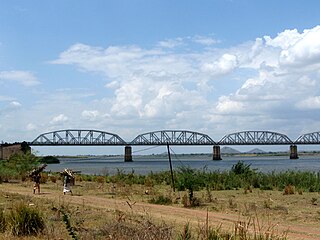
In order to cross the Zambezi River and continue the railroad operation, a ferry service was chosen, which paralyzed during the river's drought period. To eliminate the movement of the ferry, Nyasaland Railways Limited (resulting from the merger of the Shire Highlands Railway Company with the Central African Railways) and Trans-Zambezia Railways opted for the construction of the Dona Ana Bridge; the final cost of the bridge was £ 1.74 million and, for the rest of the 20th century, did not generate enough traffic to pay the interest rate, let alone repay the loans raised to build it.[10]
The extension into Malawian territory towards the north, between Blantyre and Salima, was completed in 1935, reaching the important port of Chipoka, one of the largest on Lake Malawi.[11]
In the 1940s, the Portuguese colonial government for Mozambique built a railway branch linking Dona Ana station, in Nhamayabué, to the coal mines of Moatize.[12] The Dona Ana-Moatize branch line became operational in 1949, with a length of 254 km.[1]
In the 1970s, with Mozambican independence, the extension of the line was agreed, which would depart from Salima towards the west, reaching Lilongwe and Mchinji. The works were completed and inaugurated in 1979.[13]
The Sena railway was the main bulk transport link to Malawi until 1979, when it was destroyed by RENAMO forces in the Mozambican Civil War. As the Sena railway was interconnected with the Nacala railway, at the station in the Malawian city of Nkaya, since 1970, Malawi had its second rail connection with the port of Nacala, in Mozambique. In 1984, the Nacala railway link was also lost, when the Nacala railway was destroyed by RENAMO forces.[14]
Reopening and expanding to the north
After the signing of the Rome General Peace Accords in 1992, there was an effort to reopen traffic, but devastating floods in 1997 in the valley of the Shire and Ruo rivers destroyed the important Bangula-Chiromo Road-Rail Bridge, connecting the villages of Bangula and Chiromo.[15] The event defined the state of degradation of the line between Blantyre and Nhamayabué, which has been inoperative since then. The Bangula-Chiromo bridge was rebuilt in 2003, but the section of the line between Blantyre and Nhamayabué was left behind for being more sinuous and slower, in addition to the low draft and high cargo movement of the port of Beira. It fell into disuse as of 2010, with cargoes being redirected to the Nacala railway.[16]
The subsequent discovery of mining areas in northeastern Zambia caused the railway to be extended from Mchinji (Malawi) to the locality of Chipata (Zambia).[17][18][19] The works for this extension were completed in 2019, with Chinese funding.[20]
In 2021, the Mozambican government started the rehabilitation of the section connecting Nhamayabué to Marka, with the expectation of having an auxiliary route for the transport of rail cargo from the south of Malawi.[12] At the same time, the Malawian government tendered the recovery of the section between Bangula and Marka, establishing as a priority the recovery between Bangula and Blantyre (Limbe) in a second moment.[21]
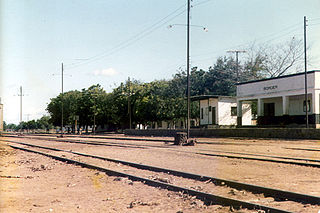
Main railway stations
Sena railway map (red line); railways with junction (in green); other railway routes (in blue).
The main railway stations of the Sena railway are:
In 1949, the Dona Ana–Moatize branch line, 254 km long, was definitively opened, connecting the very rich areas of the Benga-Moatize coal belt.[1]
It also has the Inhamitanga–Marromeu branch, which is 88 km long.[1]
Related Research Articles
Transportation in Malawi is poorly developed. The country of almost 14 million has 39 airports, 6 with paved runways and 33 with unpaved runways. It has 797 kilometres of railways, all narrow-gauge and about 45 percent of its roads are paved. Though it is landlocked, Malawi also has 700 km (435 mi) of waterways on Lake Malawi and along the Shire River.
Modes of transport in Mozambique include rail, road, water, and air. There are rail links serving principal cities and connecting the country with Malawi, Zimbabwe and South Africa. There are over 30,000km of roads, but much of the network is unpaved.
Nsanje is the main city in Nsanje District within the Southern Region of Malawi.
Zambia Railways (ZR) is the national railway company of Zambia, one of the two major railway organisations in Zambia. The other system is the binational TAZARA Railway (TAZARA) that interconnects with the ZR at Kapiri Mposhi and provides a link to the Tanzanian port of Dar es Salaam.
The Great East Road is a major road in Zambia and the main route linking its Eastern Province with the rest of the country. It is also the major link between Zambia and Malawi and between Zambia and northern Mozambique. However, the route does not carry as much traffic as many of the other regional arterial roads and between the main cities it serves, Lusaka and Chipata, it passes through rural and wilderness areas. In Lusaka the road forms the main arterial road for the eastern suburbs. The entire route from Lusaka to Chipata and the border with Malawi is designated the T4 road on Zambia's road network.
Malawi Railways was a government corporation that ran the national rail network of Malawi, Africa, until privatisation in 1999. With effect from 1 December 1999, the Central East African Railways consortium led by Railroad Development Corporation won the right to operate the network. This was the first rail privatisation in Africa which did not involve a parastatal operator.
Rail transport in Zambia is primarily provided by two systems:
The Dona Ana Bridge spans the lower Zambezi River between the towns of Vila de Sena and Mutarara in Mozambique, effectively linking the two halves of the country. It was originally constructed as a railway bridge to link Malawi and the Moatize coal fields to the port of Beira.
Portos e Caminhos de Ferro de Moçambique is a state-owned company that oversees the railway system of Mozambique and its connected ports.
Central East African Railways is a consortium formed in 1999, led by the Railroad Development Corporation, which won the right to operate the Malawi Railways network. The company was sold in September 2008 to INSITEC, an investment group based in Mozambique.
Railway stations in Mozambique include:
Malawi Railways is the national rail network in Malawi, run by a government corporation until privatisation in 1999. As of 1 December 1999 the Central East African Railways, a consortium led by Railroad Development Corporation, won the right to operate the network.
Bangula is a town of about 5000 population in southern region district of Nsanje in Malawi. There is also a commune of the same name. Its elevation is 100m. It is located on the western bank of the Shire River, near the confluence of the Shire and Ruo River. After extensive flooding in Chiromo, the municipalities were moved to Bangula. The name Bangula is roughly translated to 'place where the lions roar' – although few to no lions exist in the area anymore.
The Port of Nacala, also called the Nacala port complex, is a Mozambican port located in the cities of Nacala and Nacala-a-Velha. Is the deepest port in Southern Africa. The natural deep harbour serves landlocked Malawi with a 931-kilometre (578 mi) railway.
The history of rail transport in Mozambique began in the latter years of the nineteenth century.
The history of rail transport in Zambia began at the start of the twentieth century.
The history of rail transport in Malawi began shortly after the turn of the twentieth century.
Nacala railway, also known as Northern Corridor railway and Nacala Corridor railway, is a railway line that operates in northern Mozambique on a 912 kilometres (567 mi) line that runs west from the port city of Nacala, crossing the central region of Malawi, connecting with the coal belt of Moatize, in northwest Mozambique. It is connected to the Dona Ana-Moatize railway branch and the Sena railway (Chipata-Lilongwe-Blantyre-Nhamayabue-Dondo). It also has a 262 kilometres (163 mi) branch line from Cuamba to Lichinga.
Marka is a town located in Nsanje District in Malawi. It is the southernmost location in the country, serving as a border post for road and rail control between Malawi and Mozambique.
Vila Nova de Fronteira is a Mozambican village in the district of Mutarara, located in the province of Tete. It is located on the Malawi-Mozambique Border, in front of the city of Marka.
↑ Dell'Acqua, Gianluca.; Wegman, Fred.. Transport Infrastructure and Systems: Proceedings of the AIIT International Congress on Transport Infrastructure and Systems Roma: CRC Press. 10-12 de abril de 2017.
This page is based on this Wikipedia article Text is available under the CC BY-SA 4.0 license; additional terms may apply. Images, videos and audio are available under their respective licenses.