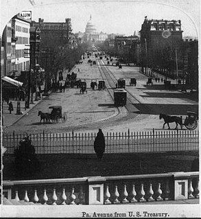
Pennsylvania Avenue is a diagonal street in Washington, D.C., and Prince George's County, Maryland, that connects the White House and the United States Capitol and then crosses the city to Maryland. In Maryland it is also Maryland Route 4 to MD 717 in Upper Marlboro, where it becomes Stephanie Roper Highway. The section between the White House and Congress is called "America's Main Street"; it is the location of official parades and processions, as well as protest marches. Moreover, Pennsylvania Avenue is an important commuter road and is part of the National Highway System.

Georgetown is a historic neighborhood and commercial and entertainment district located in Northwest Washington, D.C., situated along the Potomac River. Founded in 1751 in the Province of Maryland, the port of Georgetown predated the establishment of the federal district and the City of Washington by 40 years. Georgetown remained a separate municipality until 1871 when the United States Congress created a new consolidated government for the whole District of Columbia. A separate act, passed in 1895, specifically repealed Georgetown's remaining local ordinances and renamed Georgetown's streets to conform with those in the City of Washington.

Dupont Circle is a traffic circle, park, neighborhood, and historic district in Northwest Washington, D.C. The Dupont Circle neighborhood is bounded approximately by 16th Street NW to the east, 22nd Street NW to the west, M Street NW to the south, and Florida Avenue NW to the north. Much of the neighborhood is listed on the National Register of Historic Places. However, the local government Advisory Neighborhood Commission and the Dupont Circle Historic District have slightly different boundaries.

West Potomac Park is a U.S. national park in Washington, D.C., adjacent to the National Mall. It includes the parkland that extends south of the Lincoln Memorial Reflecting Pool, from the Lincoln Memorial to the grounds of the Washington Monument. The park is the site of many national landmarks, including the Korean War Veterans Memorial, Jefferson Memorial, Franklin Delano Roosevelt Memorial, George Mason Memorial, and the Martin Luther King Jr. Memorial.

The Embassy of Canada in Washington, D.C. is Canada's main diplomatic mission to the United States. The embassy building is located at 501 Pennsylvania Avenue Northwest, Washington, D.C., between the United States Capitol and the White House, just north of the National Gallery of Art. In addition to its diplomatic role, the embassy provides consular services for Delaware, Washington, D.C., Maryland, Virginia, and West Virginia. It also hosts a Trade Commissioner Service office, which has Maryland, Washington, D.C., Virginia, and West Virginia as its responsibilities.
Constitution Avenue is a major east–west street in the northwest and northeast quadrants of the city of Washington, D.C., in the United States. It was originally known as B Street, and its western section was greatly lengthened and widened between 1925 and 1933. It received its current name on February 26, 1931, though it was almost named Jefferson Avenue in honor of Thomas Jefferson. Constitution Avenue's western half defines the northern border of the National Mall and extends from the United States Capitol to the Theodore Roosevelt Bridge. Its eastern half runs through the neighborhoods of Capitol Hill and Kingman Park before it terminates at Robert F. Kennedy Memorial Stadium. Many federal departmental headquarters, memorials, and museums line Constitution Avenue's western segment.

Independence Avenue is a major east-west street in the southwest and southeast quadrants of the city of Washington, D.C., in the United States, running just south of the United States Capitol. Originally named South B Street, Independence Avenue SW was constructed between 1791 and 1823. Independence Avenue SE was constructed in pieces as residential development occurred east of the United States Capitol and east of the Anacostia River. Independence Avenue SW received its current name after Congress renamed the street in legislation approved on April 13, 1934. Independence Avenue SW originally had its western terminus at 14th Street SW, but was extended west to Ohio Drive SW between 1941 and 1942. The government of the District of Columbia renamed the portion of the road in the southeast quadrant of the city in 1950.
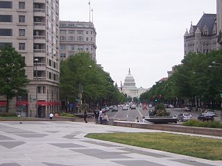
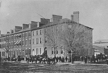
Pennsylvania Avenue National Historic Site is a National Historic Site in the city of Washington, D.C. Established on September 30, 1965, the site is roughly bounded by Constitution Avenue, 15th Street NW, F Street NW, and 3rd Street NW. The historic district includes a number of culturally, aesthetically, and historically significant structures and places, including Pennsylvania Avenue NW from the White House to the United States Capitol, the Treasury Building, Freedom Plaza, Federal Triangle, Ford's Theatre, the Old Patent Office Building, the Old Pension Office Building, Judiciary Square, and the Peace Monument.

Florida Avenue is a major street in Washington, D.C. It was originally named Boundary Street, because it formed the northern boundary of the Federal City under the 1791 L'Enfant Plan. With the growth of the city beyond its original borders, Boundary Street was renamed Florida Avenue in 1890.
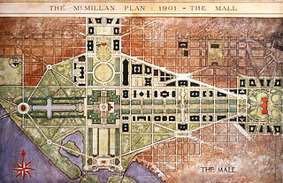
The McMillan Plan is a comprehensive planning document for the development of the monumental core and the park system of Washington, D.C., the capital of the United States. It was written in 1902 by the Senate Park Commission. The commission is popularly known as the McMillan Commission after its chairman, Senator James McMillan of Michigan.

Downtown is a neighborhood of Washington, D.C., as well as a colloquial name for the central business district in the northwest quadrant of the city. It is the fourth largest central business district in the United States. Historically, the Downtown has been defined as an area east of 16th Street NW, north of the National Mall and US Capitol complex, and south of Massachusetts Avenue, including the Penn Quarter. However, the city says that most residents, workers, and visitors think of Downtown in a broader sense—including areas as far north as Dupont Circle, the Golden Triangle, as far west as Foggy Bottom, and as far east as Capitol Hill. A small portion of this area is known as the Downtown Historic District and was listed on the NRHP in 2001.

The Belmont–Paul Women's Equality National Monument is a historic house and museum of the U.S. women's suffrage and equal rights movements located in the Capitol Hill neighborhood of Washington, D.C. The monument is named after suffragists and National Woman's Party leaders Alva Belmont and Alice Paul.
The Washington and Georgetown Railroad Company was the first streetcar company to operate in Washington, D.C. It was incorporated and started operations in 1862, using horse-drawn cars on tracks between Georgetown and the Navy Yard. Two additional lines ran on 7th Street NW/SW and 14th Street NW. In 1890, it switched to cable cars. On September 21, 1895, the company was purchased by the Rock Creek Railway and the two formed the Capital Traction Company.

Jackson Place is a Washington, D.C. street located across from the White House and forming the western border of Lafayette Square between Pennsylvania Avenue and H Street, NW, beginning just south of Connecticut Avenue.

The Sixteenth Street Historic District is a 1.25 mile (2.01 km) linear historic district in Washington, D.C., that includes all structures along 16th Street NW between H Street and Florida Avenue. The district's southern boundary is bordered by Lafayette Square, just north of the White House, and Meridian Hill Park on its northern boundary. It includes an eclectic mix of architectural styles on one of the city's most historic and important numbered streets including single and multi-family residential buildings, embassies, hotels, churches, and office buildings. Most of the district's oldest structures are religious and residential buildings, while many of the commercial buildings were built in the early to mid-20th century. The stretch of 16th Street between Scott Circle and Florida Avenue was recognized as a historic district in 1978 and listed on the National Register of Historic Places, and in 2007 it was expanded to include buildings south of Scott Circle to H Street. The historic district is also listed on the District of Columbia Inventory of Historic Sites.
Kingdon Gould III is an American real estate developer, active in the Washington, D.C.-area. He is part of the fifth generation of the Gould family of financiers, philanthropists and diplomats, which includes his father Kingdon Gould, Jr., grandfather Kingdon Gould Sr., great-grandfather George Jay Gould and great-great-grandfather Jay Gould, with associated generations of mothers, siblings, uncles, aunts and cousins.

There are a number of reportedly haunted locations in Washington, D.C. Founded on July 16, 1790, the city is the capital of the United States. Washington, D.C., has been the site of military battles, deadly duels, assassinations, untimely deaths, and associated tragedies.
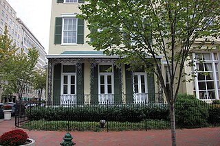
The Cutts–Madison House is an American colonial-style historic home, now used for offices located at 1520 H Street NW in Washington, D.C. The house is best known for being the residence of former First Lady Dolley Madison, who lived there from November 1837 until her death in July 1849.
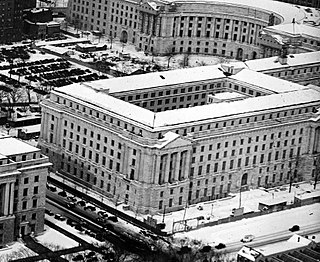
The Department of Labor Building, also known as the William Jefferson Clinton Federal Building, is a historic office building, located at 14th Street, and Constitution Avenue, Northwest, Washington, D.C., in the Federal Triangle. It was the headquarters building for the United States Department of Labor from its opening until the 1970s. It later housed the U.S. Customs Service, and is currently occupied by the U.S. Environmental Protection Agency (EPA).

Murder Bay was a disreputable slum in Washington D.C. roughly bounded by Constitution Avenue NW, Pennsylvania Avenue NW, and 15th Street NW. The area was a center of crime through the early 20th century, with an extensive criminal underclass and prostitution occurring in several brothels and hotels in the area. The area was completely rebuilt during the construction of the Federal Triangle project in the late 1920s and 1930s.