Seven Seas

Last updated

"The Seven Seas" is a figurative term for all the seas of the known world. [1] The phrase is used in reference to sailors and pirates in the arts and popular culture and can be associated with the Mediterranean Sea, the Arabian Seven Seas east of Africa and India (as told with Sinbad's seven journeys, and Captain Kidd), or is sometimes applied to the Caribbean Sea and seas around the Americas (with pirates such as Blackbeard).

Contents

The terminology of a "seven seas" with varying definitions was part of the vernacular of several people (as in the prior mentioned seas of Arabic literature), long before the oceans of the world became known (to those peoples). The term can now also be taken to refer to these seven oceanic bodies of water: [2] [3] [4]

The World Ocean is also known as just "the sea", the expanse emanating from any marginal sea. The International Hydrographic Organization lists over 23 distinct bodies of water called seas. [5]

Arabs

The Arabs and their near neighbours considered the Seven Seas (Arabic : البحار السبعة) to be the seas that they encountered in their voyages to The East. They were trading routes in ancient times and since the time of Muhammad, they are the places where Islam spread and is widely practised.

In the 9th century AD, author Ya'qubi wrote:

Whoever wants to go to China must cross seven seas, each one with its own color and wind and fish and breeze, completely unlike the sea that lies beside it. The first of them is the Sea of Fars, which men sail setting out from Siraf. It ends at Ra’s al-Jumha; it is a strait where pearls are fished. The second sea begins at Ra’s al-Jumha and is called Larwi. It is a big sea, and in it is the Island of Waqwaq and others that belong to the Zanj. These islands have kings. One can only sail this sea by the stars. It contains huge fish, and in it are many wonders and things that pass description. The third sea is called Harkand, and in it lies the Island of Sarandib, in which are precious stones and rubies. Here are islands with kings, but there is one king over them. In the islands of this sea grow bamboo and rattan. The fourth sea is called Kalah and is shallow and filled with huge serpents. Sometimes they ride the wind and smash ships. Here are islands where the camphor tree grows. The fifth sea is called Salahit and is very large and filled with wonders. The sixth sea is called Kardanj; it is very rainy. The seventh sea is called the sea of Sanji, also known as Kanjli. It is the sea of China; one is driven by the south wind until one reaches a freshwater bay, along which are fortified places and cities, until one reaches Khanfu. [6]

This passage demonstrates the Seven Seas as referenced in Medieval Arabian literature:

Arab seafarers may have also considered other important seas nearby which they navigated regularly, including the Black Sea, Caspian Sea, Red Sea, Mediterranean Sea, and Adriatic Sea.

East Indies

In British Colonial times the Clipper Ship Tea Route from China to England was the longest trade route in the world. It took sailors through seven seas near the Dutch East Indies: the Banda Sea, the Celebes Sea, the Flores Sea, the Java Sea, the South China Sea, the Sulu Sea, and the Timor Sea. The Seven Seas referred to those seas, and if someone had sailed the Seven Seas it meant he had sailed to, and returned from, the other side of the world.

Greeks

Historic seven seas Seven seas.png
Historic seven seas

The term in modern usage originated from Greece, where the seven seas were considered as:[ citation needed ]

Romans

The meaning of septem maria (Latin) in Ancient Rome is different than the phrase "seven seas" in the modern era. The navigable network in the mouths of the Po river discharges into saltmarshes on the Adriatic shore and was colloquially called the "Seven Seas" in ancient Roman times. Pliny the Elder, a Roman author and fleet commander, wrote about these lagoons, separated from the open sea by sandbanks:

All those rivers and trenches were first made by the Etruscans, thus discharging the flow of the river across the marshes of the Atriani called the Seven Seas, with the famous harbor of the Etruscan town of Atria which formerly gave the name of Atriatic to the sea now called the Adriatic. [11]

A history of Venice states:

The expression "to sail the seven seas" was a classical flourish signifying nautical skill. It was applied to the Venetians long before they sailed the oceans. [12]

Persians

The Persians used the term "the Seven Seas" to refer to the streams forming the Oxus River. [1]

Talmudists

The Babylonian Talmud mentions seven seas and four rivers that surround the land of Israel. In Tractate Bava Batra, fol. 74b, it reads:

When R. Dimi came he said R. Yohanan said: "What is the meaning of the verse, 'For he hath founded it upon the seas and established it upon the floods.' (Ps. 24:2)? This refers to the seven seas and four rivers that surround the land of Israel. And what are the seven seas? The sea of Tiberias, the Sea of Sodom, the Sea of Helath, the Sea of Hiltha, the Sea of Sibkay, the Sea of Aspamia and the Great Sea. And what are the four rivers? The Jordan, the Yarmuk, the Keramyhon and Pigah." [13] [14]

According to this and other passages, the Talmudic Seven Seas include: [15]

Various transliterations for the sea names from Hebrew exist. For Helath: Chelath and Shelyith. For Hiltha: Chiltha and Chultha. For Sibkay: Sibchi and Somcho. And for Aspamia: Apamia. [15]

The 17th century churchman and scholar John Lightfoot mentions this set of seas in his Commentary on the New Testament. A chapter titled The Seven Seas according to the Talmudists, and the four Rivers compassing the Land includes the "Great Sea" (now called the Mediterranean Sea), the "Sea of Tiberias" (Sea of Galilee), the "Sea of Sodom" (Dead Sea), the "Lake of Samocho" (probably the (mostly) dried-up Hula Lake, called Semechonitis by Josephus and lake Sumchi in the Talmud), also called the "Sibbichaean". [16] Lightfoot does not comment on the remaining three seas.

Early modern

Modern boundaries of marginal seas, numbering far more than seven. Oceans and seas boundaries map-en.svg
Modern boundaries of marginal seas, numbering far more than seven.

After the discovery of the Americas during the Age of Discovery, the "seven seas" were reckoned by some as: [4]

The last two of these are now reckoned to be part of the Atlantic Ocean, and the Mediterranean either part of the Atlantic or omitted. Splitting the Atlantic and Pacific into north and south and adding the Southern Ocean returns the list to seven.

Detailed reckonings of the divisions of the world ocean into oceans and seas is not limited to lists of seven. For example, the International Hydrographic Organization recognizes many marginal seas; some saltwater lakes and the freshwater Sea of Galilee also have "sea" in their names.

See also

Related Research Articles

<span class="mw-page-title-main">Indian Ocean</span> Ocean bounded by Africa, Asia, and Australia

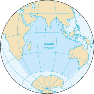
The Indian Ocean is the third-largest of the world's five oceanic divisions, covering 70,560,000 km2 (27,240,000 sq mi) or approx. 20% of the water on Earth's surface. It is bounded by Asia to the north, Africa to the west and Australia to the east. To the south it is bounded by the Southern Ocean, or Antarctica, depending on the definition in use. Along its core, the Indian Ocean has large marginal, or regional seas, such as the Andaman Sea, the Arabian Sea, the Bay of Bengal, and the Laccadive Sea.

<span class="mw-page-title-main">Geography of Israel</span>

The geography of Israel is very diverse, with desert conditions in the south, and snow-capped mountains in the north. Israel is located at the eastern end of the Mediterranean Sea in West Asia. It is bounded to the north by Lebanon, the northeast by Syria, the east by Jordan and the West Bank, and to the southwest by Egypt. To the west of Israel is the Mediterranean Sea, which makes up the majority of Israel's 273 km (170 mi) coastline, and the Gaza Strip. Israel has a small coastline on the Red Sea in the south.

<span class="mw-page-title-main">Lists of islands</span>

This is a list of the lists of islands in the world grouped by country, by continent, by body of water, and by other classifications. For rank-order lists, see the other lists of islands below.

<span class="mw-page-title-main">Mediterranean Sea</span> Sea between Europe, Africa and Asia

The Mediterranean Sea is a sea connected to the Atlantic Ocean, surrounded by the Mediterranean Basin and almost completely enclosed by land: on the north by Southern Europe and Anatolia, on the south by North Africa, and on the east by the Levant in West Asia. The Mediterranean has played a central role in the history of Western civilization. Geological evidence indicates that around 5.9 million years ago the Mediterranean was cut off from the Atlantic and was partly or completely desiccated over a period of some 600,000 years during the Messinian salinity crisis before being refilled by the Zanclean flood about 5.3 million years ago.

<span class="mw-page-title-main">Sea of Galilee</span> Freshwater lake in Israel

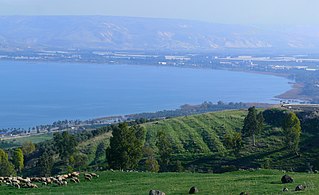
The Sea of Galilee, also called Lake Tiberias or Kinneret, is a freshwater lake in Israel. It is the lowest freshwater lake on Earth and the second-lowest lake in the world, at levels between 215 and 209 metres below sea level. It is approximately 53 km (33 mi) in circumference, about 21 km (13 mi) long, and 13 km (8.1 mi) wide. Its area is 166.7 km2 (64.4 sq mi) at its fullest, and its maximum depth is approximately 43 metres (141 ft). The lake is fed partly by underground springs, but its main source is the Jordan River, which flows through it from north to south and exits the lake at the Degania Dam.

<span class="mw-page-title-main">Tiberias</span> City in northern Israel

Tiberias is an Israeli city on the western shore of the Sea of Galilee. A major Jewish center during Late Antiquity, it has been considered since the 16th century one of Judaism's Four Holy Cities, along with Jerusalem, Hebron, and Safed. In 2022, it had a population of 48,472.

<span class="mw-page-title-main">Geographical exploration</span> Act of traveling and searching for resources or for information about the land or space itself

Geographical exploration, sometimes considered the default meaning for the more general term exploration, refers to the practice of discovering remote lands and regions of the planet Earth. It is studied by geographers and historians.

<span class="mw-page-title-main">Magdala</span> Ancient Hebrew city

Magdala was an ancient Jewish city on the shore of the Sea of Galilee, 5 km north of Tiberias. In the Babylonian Talmud it is known as Magdala Nunayya, and which some historical geographers think may refer to Tarichaea, literally: "the place of processing fish." It is believed to be the birthplace of Mary Magdalene. Until the 1948 Arab–Israeli War, a small Arab village, al-Majdal, stood at the site of ancient Magdala. The Israeli municipality of Migdal now extends into the area.

<span class="mw-page-title-main">Ocean exploration</span> Part of oceanography describing the exploration of ocean surfaces

Ocean exploration is a part of oceanography describing the exploration of ocean surfaces. Notable explorations were undertaken by the Greeks, the Romans, the Polynesians, the Phoenicians, Phytheas, Herodotus, the Vikings, the Portuguese and Muslims. Scientific investigations began with early scientists such as James Cook, Charles Darwin, and Edmund Halley. Ocean exploration itself coincided with the developments in shipbuilding, diving, navigation, depth, measurement, exploration, and cartography.

<span class="mw-page-title-main">Triple Divide Peak (Montana)</span> Mountain in Montana, United States. Located at the hydrological apex of North America.

Triple Divide Peak is located in the Lewis Range, part of the Rocky Mountains in North America. The peak is a feature of Glacier National Park in the state of Montana in the United States. The summit of the peak, the hydrological apex of the North American continent, is the point where two of the principal continental divides in North America converge, the Continental Divide of the Americas and the Northern or Laurentian Divide.

USS <i>Ainsworth</i>

USS Ainsworth (DE/FF-1090) was a Knox-class frigate named for Vice Admiral Walden L. Ainsworth (1886–1960). Ainsworth (DE-1090) was laid down at Westwego, Louisiana, on 11 June 1971 by Avondale Shipyards, Inc.; launched on 15 April 1972; sponsored by Mrs. Katharine Gardner Ainsworth, the widow of Vice Admiral Ainsworth; and commissioned on 31 March 1973 at the Norfolk Naval Shipyard, Portsmouth, Virginia.

<span class="mw-page-title-main">Continental divide</span> Drainage divide on a continent

A continental divide is a drainage divide on a continent such that the drainage basin on one side of the divide feeds into one ocean or sea, and the basin on the other side either feeds into a different ocean or sea, or else is endorheic, not connected to the open sea. Every continent on earth except Antarctica has at least one continental drainage divide; islands, even small ones like Killiniq Island on the Labrador Sea in Canada, may also host part of a continental divide or have their own island-spanning divide. The endpoints of a continental divide may be coastlines of gulfs, seas or oceans, the boundary of an endorheic basin, or another continental divide. One case, the Great Basin Divide, is a closed loop around an endorheic basin. The endpoints where a continental divide meets the coast are not always definite since the exact border between adjacent bodies of water is usually not clearly defined. The International Hydrographic Organization's publication Limits of Oceans and Seas defines exact boundaries of oceans, but it is not universally recognized. Where a continental divide meets an endorheic basin, such as the Great Divide Basin of Wyoming, the continental divide splits and encircles the basin. Where two divides intersect, they form a triple divide, or a tripoint, a junction where three watersheds meet.

<span class="mw-page-title-main">Outline of oceanography</span> Hierarchical outline list of articles related to oceanography

The following outline is provided as an overview of and introduction to Oceanography.

<span class="mw-page-title-main">Southern Ocean</span> Ocean around Antarctica

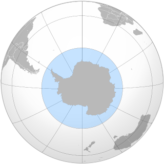
The Southern Ocean, also known as the Antarctic Ocean, comprises the southernmost waters of the world ocean, generally taken to be south of 60° S latitude and encircling Antarctica. With a size of 20,327,000 km2 (7,848,000 sq mi), it is regarded as the second-smallest of the five principal oceanic divisions: smaller than the Pacific, Atlantic, and Indian oceans but larger than the Arctic Ocean.

<span class="mw-page-title-main">Borders of the oceans</span> Limits of Earths oceanic waters

The borders of the oceans are the limits of Earth's oceanic waters. The definition and number of oceans can vary depending on the adopted criteria. The principal divisions of the five oceans are the Pacific Ocean, Atlantic Ocean, Indian Ocean, Southern (Antarctic) Ocean, and Arctic Ocean. Smaller regions of the oceans are called seas, gulfs, bays, straits, and other terms. Geologically, an ocean is an area of oceanic crust covered by water.

<span class="mw-page-title-main">Fishing industry in Israel</span> Branch of the Israeli economy

Fishing in Israel is a branch of the Israeli economy with historical significance. The three main natural fishing zones are the Mediterranean Sea, the Gulf of Aqaba, and the Kinneret. A fourth area that was once historically significant, Lake Hula, no longer exists, as it was drained in the 1950s. In addition, aquaculture the growth of fish in ponds or in cages, is rising in prominence.

References

  1. 1 2 "What are the "seven seas"?". The Straight Dope. 19 January 1999.
  2. The New Dictionary of Cultural Literacy (3rd ed.). Houghton Mifflin Company. 2002. Archived from the original on March 14, 2009. Popular expression for all of the world's oceans.
  3. ""Seven" – Oxford Dictionaries". Oxford University Press. Archived from the original on June 3, 2013. Retrieved 2015-04-10. the seven seas: 2. All the oceans of the world (conventionally listed as the Arctic, Antarctic, North Pacific, South Pacific, North Atlantic, South Atlantic, and Indian Oceans).
  4. 1 2 "What and Where are the Seven Seas?". World Atlas. 11 May 2021.
  5. Appendices: IHO Publication S-23 – Limits of Oceans and Seas; Draft 4th Edition. IHO. 2002. Retrieved 2022-10-25.
  6. Lunde, Paul (July–August 2005). "The Seas of Sindbad". Saudi Aramco World. 56 (4). Archived from the original on 2007-02-08. Retrieved 2007-03-27.
  7. "The Pakistan Sea". Cowasjee Articles. December 24, 1993. Archived from the original on October 25, 2009.
  8. McKinnon, E. Edwards (October 1988). "Beyond Serandib: A Note on Lambri at the Northern Tip of Aceh". Indonesia. 46 (46): 103–121. doi:10.2307/3351047. hdl: 1813/53892 . JSTOR   3351047.
  9. 1 2 3 M. Th. Houtsma (1993). E. J. Brill's first encyclopaedia of Islam 1913–1936. BRILL. ISBN   978-90-04-08265-6.
  10. "Tumasik Kingdom". Melayu Online. Archived from the original on 2009-03-12. Retrieved 2008-09-05.
  11. Pliny the Elder. "Chapter 16". Historia Naturalis.
  12. Lane, Frederic Chapin (1973). Venice, a Maritime Republic. Johns Hopkins University Press. p. 4. ISBN   0-8018-1460-X.
  13. Neusner, Jacob (2011). First steps in the Talmud : a guide to the confused. Lanham, Md.: University Press of America. p. 113. ISBN   978-0-7618-5435-7.
  14. "Babylonian Talmud: Bava Batra 74" . Retrieved 7 June 2018.
  15. 1 2 Schwarz, Rabbi Joseph. "Seas, Rivers, Mountains, and Valleys of Palestine" . Retrieved 9 September 2017.
  16. Lightfoot, John. "The seven Seas according to the Talmudists, and the four Rivers compassing the Land". A Chorographical Century. Archived from the original on 2008-05-15. Retrieved 2008-09-05.