Sharon station

Last updated
Sharon
Sharon station from Depot Street stairs, November 2016.JPG
Platforms and depot building at Sharon in November 2016
General information
Location1 Upland Road
Sharon, Massachusetts
Coordinates 42°07′29″N71°11′02″W / 42.12475°N 71.18400°W / 42.12475; -71.18400
Line(s) Attleboro Line (Northeast Corridor)
Platforms2 side platforms
Tracks2
Construction
Parking546 spaces ($4.00 fee) [1]
Bicycle facilities8 spaces
AccessibleYes
Other information
Fare zone4
History
OpenedJune 1835
Rebuilt1936
September 30, 2014
Passengers
20181,308 (weekday average boardings) [2]
Services
Preceding station MBTA.svg MBTA Following station
Mansfield Providence/​Stoughton Line Canton Junction
Former services
Preceding station MBTA.svg MBTA Following station
Mansfield
toward Foxboro
Foxboro event service
1989–1994
Canton Junction
Preceding station New York, New Haven and Hartford Railroad Following station
East Foxboro
toward New Haven
Shore Line Canton Junction
toward Boston
Location
Sharon station

Sharon station is an MBTA Commuter Rail station in Sharon, Massachusetts. It serves the Providence/Stoughton Line. The station has two separate entrances for inbound trains to Boston and for outbound trains to Providence and beyond. New platforms were constructed in 2014 to make the station accessible.

Contents

History

1870s-built Sharon station on a 1908 postcard Sharon station 1908 postcard.jpg
1870s-built Sharon station on a 1908 postcard

The Boston and Providence Railroad started full operations between the two cities in June 1835, including a station at the modern location in Sharon. [3] [4] In 1871, the original Sharon station was replaced by a larger building similar to those still extant at East Greenwich and Kingston in Rhode Island. [5] [6] The Boston and Providence was leased by the Old Colony Railroad in 1888, which was in turn absorbed by the New York, New Haven & Hartford Railroad in 1893. [4]

The current inbound station building and the small outbound shelter were designed by F.J. Pitcher and built in 1936 by the New Haven Railroad. [5] The Depot Road grade crossing was also replaced with a road bridge in 1936–37 at a cost of $127,094 (equivalent to $2,200,000in 2023). [7] [8] It was considered a priority for elimination because of busy rail traffic – 78 daily trains – and because the Comet operated through Sharon at up to 95 miles per hour (153 km/h). [9] [10] The state issued a $9,789 contract (equivalent to $163,000in 2023) in November 1937 for construction of platform canopies and other improvements related to the crossing elimination. [11]

Penn Central took over New Haven Railroad commuter operations on January 1, 1969. On January 27, 1973, the MBTA acquired a number of Penn Central's Boston commuter lines, including the Providence/Stoughton Line. [12] In June 1973, the MBTA began subsidizing commuter rail service to Sharon. The town had been part of the MBTA district since 1964. [12]

From 1989 to 1994, Boston–Foxboro trains for events at Foxboro Stadium operated over the Northeast Corridor, with intermediate stops including Sharon. [13] [14] Boston–Foxboro service was rerouted over the Franklin Line in 1995. [15] Overcrowding of the parking lot led to plans for a 102-space expansion in 1999 and a 31-space expansion in 2003; neither were built. [16] [17]

Accessibility

Mini-high platforms at Sharon station in 2016 Mini-high platforms at Sharon station, November 2016.JPG
Mini-high platforms at Sharon station in 2016

Until 2014, Sharon was the busiest station on the system that was not accessible. All other stations with daily ridership above 1,000 passengers had accessible high-level platforms, as did all other stations on the busy Providence/Stoughton Line. [18] After an accessibility complaint was filed in May 2011, construction was mandated to take place by November 1, 2012. No construction took place in 2012, prompting concerns that the commuter rail stop - not just the building - would be closed. [19] On October 15, 2012, the state's Architectural Access Board granted the MBTA an extension until October 1, 2013 to make the station accessible. [20]

The project, which included adding mini-high platforms and improving handicapped access to the building, was originally expected to begin in the spring of 2013 and to be completed that fall at a cost of $1.2 million. [20] In May 2013, the MBTA issued a request for bids for the then-$2.6 million project, with work to start in August. [21] [22] Notice to Proceed was given to the chosen contractor on September 5, 2013, with work to be completed by February 2014. [21] Noise testing begun in April 2014, followed by ongoing construction of mini-high platforms as well as improvements to the building and parking lot. [23]

The accessible parking spots and the building retrofits were completed during May 2014. [1] The mini-high platforms were opened on September 30, 2014. [24]

The stairs to the platforms were closed on January 29, 2023. [25]

Other Sharon stations

Sharon Heights station in the early 20th century Sharon Heights station postcard.jpg
Sharon Heights station in the early 20th century

A station was located in Sharon Heights near Garden Street, about a mile south of Sharon proper. [3] [4] [26] It was closed sometime in the mid-20th century, at least a decade before the 1973 MBTA takeover.

In the late 1800s, a short-lived half-mile branch line led from Sharon Heights to a summer-only station at Lake Massapoag. [26] The branch was also used to haul ice from the lake to surrounding locales. [3] The remnants of the wye to the branch are still visible from passing trains on the main line.

Related Research Articles

<span class="mw-page-title-main">MBTA Commuter Rail</span> Greater Boston commuter rail system

The MBTA Commuter Rail system serves as the commuter rail arm of the Massachusetts Bay Transportation Authority's (MBTA's) transportation coverage of Greater Boston in the United States. Trains run over 394 mi (634 km) of track to 134 stations. It is operated under contract by Keolis, which took over operations on July 1, 2014, from the Massachusetts Bay Commuter Railroad Company (MBCR).

<span class="mw-page-title-main">Route 128 station</span> Rail station in Westwood, MA

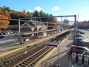
Route 128 station is a passenger rail station located at the crossing of the Northeast Corridor and Interstate 95/US Route 1/Route 128 at the eastern tip of Dedham and Westwood, Massachusetts, United States. The station is shared by Amtrak and the Massachusetts Bay Transportation Authority (MBTA). It is served by most MBTA Commuter Rail Providence/Stoughton Line trains, as well as by all Amtrak Northeast Regional and Acela intercity trains. The station building, platforms, and parking garage are all fully accessible. It is the 23rd busiest Amtrak station in the country and the fifth busiest in New England.

<span class="mw-page-title-main">Forest Hills station (MBTA)</span> Transit station in Boston, Massachusetts, US

Forest Hills station is an intermodal transfer station in Boston, Massachusetts. It serves the MBTA rapid transit Orange Line and three MBTA Commuter Rail lines and is a major terminus for MBTA bus routes. It is located in Forest Hills, in the southern part of the Jamaica Plain neighborhood. Most Providence/Stoughton Line and Franklin/Foxboro Line trains, and all Amtrak Northeast Corridor trains, pass through the station without stopping. Forest Hills station is fully accessible on all modes.

<span class="mw-page-title-main">South Attleboro station</span> Railway station in Attleboro, Massachusetts, US

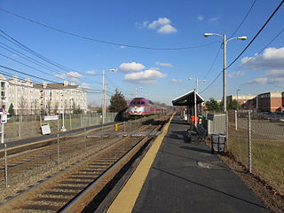
South Attleboro station is an MBTA Commuter Rail Providence/Stoughton Line station in Attleboro, Massachusetts. It is located under Newport Avenue in the South Attleboro neighborhood, just north of the Rhode Island border. The station has two side platforms serving the two tracks of the Northeast Corridor, formerly connected by a footbridge to a park-and-ride lot; only the north platform is in use.

<span class="mw-page-title-main">Fairmount Line</span> MBTA Commuter Rail line

The Fairmount Line or Dorchester Branch is a line of the MBTA Commuter Rail system in Boston, Massachusetts, USA. Except for a short portion in Milton, it lies entirely within Boston, running southwest from South Station through the neighborhoods of Dorchester, Mattapan and Hyde Park. Weekend service began on November 29, 2014. Most trains reverse direction at the south end at Readville, but some Franklin/Foxboro Line trains use the Fairmount Line rather than the Northeast Corridor.

<span class="mw-page-title-main">Foxboro station</span> Train station in Foxborough, Massachusetts, US

Foxboro station is an MBTA Commuter Rail station in Foxborough, Massachusetts, located adjacent to Gillette Stadium and the Patriot Place shopping center. The station has a single side platform serving the main track of the Framingham Secondary. It is the terminus of a branch of the Franklin/Foxboro Line service, and is served by trains from Boston via the Franklin/Foxboro Line and from Providence via the Providence/Stoughton Line during events at Gillette Stadium.

<span class="mw-page-title-main">Franklin/Foxboro Line</span> MBTA Commuter Rail line

The Franklin/Foxboro Line is part of the MBTA Commuter Rail system. It runs from Boston's South Station in a southwesterly direction toward Franklin, Massachusetts. Most weekday trains use the Northeast Corridor before splitting off onto the namesake Franklin Branch at Readville, though some weekday trains and all weekend trains use the Dorchester Branch between Boston and Readville.

<span class="mw-page-title-main">Providence/Stoughton Line</span> Line of the Boston MBTA Commuter Rail system

The Providence/Stoughton Line is an MBTA Commuter Rail service in Massachusetts and Rhode Island, primarily serving the southwestern suburbs of Boston. Most service runs entirely on the Northeast Corridor between South Station in Boston and Providence station or Wickford Junction station in Rhode Island, while the Stoughton Branch splits at Canton Junction and terminates at Stoughton. It is the longest MBTA Commuter Rail line, and the only one that operates outside Massachusetts. The line is the busiest on the MBTA Commuter Rail system, with 17,648 daily boardings in an October 2022 count.

<span class="mw-page-title-main">Union Station (Walpole, Massachusetts)</span> Railway station in Walpole, Massachusetts, US

Union Station, also known as Walpole station, is an MBTA Commuter Rail station in Walpole, Massachusetts. It is located at the crossing of the Franklin Branch and Framingham Secondary just west of downtown Walpole. The station has one side platform on the Franklin Branch serving the Franklin/Foxboro Line service. Unlike most MBTA stations, Walpole station is not accessible.

<span class="mw-page-title-main">Hyde Park station (MBTA)</span> Train station in Boston, Massachusetts, US

Hyde Park station is an MBTA Commuter Rail station in Boston, Massachusetts. It primarily serves the Providence/Stoughton Line, and also serves some weekday outbound Franklin/Foxboro Line trains. It is located on the Northeast Corridor in the Hyde Park neighborhood.

<span class="mw-page-title-main">Canton Junction station</span> Railway station in Canton, Massachusetts, US

Canton Junction station is an MBTA Commuter Rail station in Canton, Massachusetts. It serves the Providence/Stoughton Line, and is planned for future service on the South Coast Rail line. It is located slightly north of the Canton Viaduct and west of downtown Canton.

<span class="mw-page-title-main">Readville station</span> Railway station in Boston, Massachusetts, US

Readville station is a Massachusetts Bay Transportation Authority (MBTA) commuter rail station located in the Readville section of the Hyde Park neighborhood of Boston, Massachusetts. It is served by the MBTA Commuter Rail Fairmount, Franklin/Foxboro, and Providence/Stoughton Lines. Readville is the outer terminus for most Fairmount service, though some trips continue as Franklin/Foxboro Line trains. The station is located at a multi-level junction, with the Attleboro Line tracks at ground level and the Dorchester Branch above. Franklin/Foxboro Line trains that run on the Northeast Corridor use a connecting track with a separate platform. An MBTA maintenance and storage yard and a CSX Transportation freight yard are located near the station.

<span class="mw-page-title-main">Dedham Corporate Center station</span> Railroad station in Dedham, Massachusetts

Dedham Corporate Center station is an MBTA Commuter Rail station in Dedham, Massachusetts. It serves the Franklin/Foxboro Line, and is located just off exit 28 of Interstate 95/Route 128. It serves mostly as a park-and-ride location. The station consists of two platforms serving the Franklin/Foxboro Line's two tracks. Previous stations named Dedham Junction and Rust Craft (1955-1977) were located near the modern site.

<span class="mw-page-title-main">Norwood Depot</span> Rail station in Norwood, Massachusetts, US

Norwood Depot is an MBTA Commuter Rail Franklin/Foxboro Line station located in downtown Norwood, Massachusetts. The station has two side platforms serving the two tracks of the Franklin Branch, each with a mini-high section for accessibility. The Norfolk County Railroad opened through South Dedham in 1849, with a station at the modern location. It was renamed Norwood in 1872. The line came under control of the New York, New Haven and Hartford Railroad in 1895. The Massachusetts Bay Transportation Authority (MBTA) began subsidizing service in 1966 and purchased the line in 1973. Under the MBTA, renovations to the station were made around 1977 and 1992.

<span class="mw-page-title-main">Norwood Central station</span> Rail station in Massachusetts

Norwood Central station is an MBTA Commuter Rail Franklin/Foxboro Line station located near downtown Norwood, Massachusetts. The station has two side platforms serving the two tracks of the Franklin Branch, each with a mini-high section for accessibility. It serves as a park-and-ride location for Boston's southwest suburbs; with 1,041 daily riders it is the busiest station on the line outside Boston. The former station building, a one-story yellow brick structure, has been converted to commercial use.

<span class="mw-page-title-main">Attleboro station (Massachusetts)</span> Railway station in Attleboro, Massachusetts, US

Attleboro station is a commuter rail station on the MBTA's Providence/Stoughton Line located in Attleboro, Massachusetts. By a 2018 count, Attleboro had 1,547 daily riders, making it the fourth busiest station on the system outside Boston.

<span class="mw-page-title-main">Mansfield station (MBTA)</span> Rail station in Mansfield, Massachusetts, US

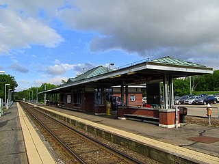
Mansfield station is an MBTA Commuter Rail station in Mansfield, Massachusetts. Located in downtown Mansfield, it serves the Providence/Stoughton Line. With 1,966 weekday boardings in a 2018 count, Mansfield is the third-busiest station on the system outside Boston.

<span class="mw-page-title-main">Stoughton station</span> Rail station in Stoughton, Massachusetts, US

Stoughton station is an MBTA Commuter Rail station in downtown Stoughton, Massachusetts. It is the current terminus of the Stoughton Branch of the Providence/Stoughton Line. The station has a parking lot to serve local riders and those driving from further south, as Stoughton is close to the Massachusetts Route 24 expressway. Stoughton currently has one platform serving one track; the platform has a mini-high section for accessibility.

<span class="mw-page-title-main">Forge Park/495 station</span> Rail station in Franklin, Massachusetts, US

Forge Park/495 station is a Massachusetts Bay Transportation Authority (MBTA) commuter rail station served by the Franklin/Foxboro Line. It is located off Route 140 near Interstate 495 in Franklin, Massachusetts, United States. A park and ride station serving southwestern Boston suburbs and northeastern Rhode Island, it is the outer terminus of the Franklin/Foxboro Line. The station has two side platforms serving a single track, with an accessible mini-high platform and a station building on the south platform.

<span class="mw-page-title-main">Back Bay station</span> Railway station in Boston, Massachusetts, US

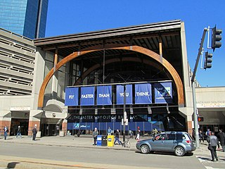
Back Bay station is an intermodal passenger station in Boston, Massachusetts. It is located just south of Copley Square in Boston's Back Bay and South End neighborhoods. It serves MBTA Commuter Rail and MBTA subway routes, and also serves as a secondary Amtrak intercity rail station for Boston. The present building, designed by Kallmann McKinnell & Wood, opened in 1987. It replaced the New Haven Railroad's older Back Bay station – which opened in 1928 as a replacement for an 1899-built station – as well as the New York Central's Huntington Avenue and Trinity Place stations which had been demolished in 1964.

References

  1. 1 2 "Sharon Disabilities Commission Minutes, May 28, 2014" (PDF). Sharon Disabilities Commission. 28 May 2014. Archived from the original (PDF) on April 9, 2017. Retrieved 5 July 2014.
  2. Central Transportation Planning Staff (2019). "2018 Commuter Rail Counts". Massachusetts Bay Transportation Authority.
  3. 1 2 3 E. Robinson (1888). "Foxborough & Sharon 1888 Plate 45 - Sharon Heights, Franklin Center". Atlas of Norfolk County, 1888. WardMaps LLC. Retrieved 22 October 2012.
  4. 1 2 3 Karr, Ronald Dale (1995). The Rail Lines of Southern New England. Branch Line Press. pp. 146–149. ISBN   0942147022.
  5. 1 2 Roy, John H. Jr. (2007). A Field Guide to Southern New England Railroad Depots and Freight Houses. Branch Line Press. pp. 225–226. ISBN   9780942147087.
  6. "The Boston & Providence Railroad Corporation". Boston Evening Transcript. November 8, 1871. p. 2 via Newspapers.com.
  7. Annual Report of the Department of Public Works for the Year Ending November 30, 1936. Massachusetts Department of Public Works. 1937. p. 28.
  8. "Bids For Sidewalks And Grade Crossings Opened". The Boston Globe. May 1, 1936. p. 14 via Newspapers.com.
  9. "Crossing Projects Discussed By Foy". The Boston Globe. July 25, 1935. p. 15 via Newspapers.com.
  10. "Worst Crossing "Is In Sharon"". The Boston Globe. July 23, 1935. p. 15 via Newspapers.com.
  11. Annual Report of the Department of Public Works for the Year Ending November 30, 1937. Massachusetts Department of Public Works. 1937. p. 39.
  12. 1 2 Belcher, Jonathan. "Changes to Transit Service in the MBTA district" (PDF). Boston Street Railway Association.
  13. Ackerman, Jerry (September 18, 1989). "The latest words from the streets". Boston Globe. p. 15 via Newspapers.com.
  14. "How to get to the game". Boston Globe. December 4, 1994. p. 63 via Newspapers.com.
  15. "How to get to the game". Boston Globe. September 10, 1995. p. 93 via Newspapers.com.
  16. Preer, Robert (November 21, 1999). "MBTA set to expand station parking". Boston Globe. pp. 21, 32 via Newspapers.com. Open Access logo PLoS transparent.svg
  17. Massey, Joanna (October 2, 2003). "Supply and demand clash at MBTA lots". Boston Globe. p. 201 via Newspapers.com. Open Access logo PLoS transparent.svg
  18. "Ridership and Service Statistics" (PDF) (14th ed.). Massachusetts Bay Transportation Authority. 2014.
  19. Salisbury, Phil (October 1, 2012). "Sharon train station may close due to lack of handicap access". Wicked Local Sharon. Retrieved October 22, 2012.
  20. 1 2 Vogler, Paula (18 October 2012). "Sharon commuter rail station gets access waiver extension". Wicked Local Sharon. Retrieved 22 October 2012.
  21. 1 2 Davey, Richard A. & Scott, Beverly A. (17 May 2013). "Notice to Bidders" (PDF). Massachusetts Bay Transportation Authority. Retrieved 20 May 2013.
  22. Barnes, Jennette (20 July 2013). "Train accessibility plan outlined". Boston Globe. Retrieved 21 July 2013.
  23. Taurasi, Liz (7 April 2014). "MBTA Work at Sharon Station Nightly Through April 25". Sharon Patch. Retrieved 8 April 2014.
  24. "Sharon Commission on Disabilities Minutes, October 22, 2014" (PDF). Sharon Disabilities Commission. October 22, 2014. Archived from the original (PDF) on July 9, 2016. Retrieved November 22, 2016.
  25. "A;erts: Providence/Stoughton Line". Massachusetts Bay Transportation Authority. January 29, 2023. Archived from the original on April 18, 2023.
  26. 1 2 George J. Varney & Rev. Elias Nason (1890). A gazetteer of the State of Massachusetts with numerous illustrations. B.B. Russell. pp. 588–589. Retrieved 22 October 2012.

Commons-logo.svg Media related to Sharon station at Wikimedia Commons