
Yorkshire and the Humber is one of nine official regions of England at the first level of ITL for statistical purposes. The population in 2011 was 5,284,000 with its largest settlements being Leeds, Sheffield, Bradford, Hull, and York.

Kings Cross is a district on either side of Euston Road, in north London, England, 1.5 miles (2.4 km) north of Charing Cross. It is bordered by Barnsbury to the north, Clerkenwell and Islington to the east, Holborn to the south and Euston to the west. It is served by two major rail termini, St Pancras and King's Cross. King's Cross station is the terminus of one of the major rail routes between London and the North.

West Yorkshire is a metropolitan and ceremonial county in the Yorkshire and the Humber region of England.

The M62 is a 107-mile-long (172 km) west–east trans-Pennine motorway in Northern England, connecting Liverpool and Hull via Manchester, Bradford, Leeds and Wakefield; 7 miles (11 km) of the route is shared with the M60 orbital motorway around Manchester. The road is part of the unsigned Euroroutes E20 and E22.

The A61 is a major trunk road in England connecting Derby and Thirsk in North Yorkshire by way of Alfreton, Clay Cross, Chesterfield, Sheffield, Barnsley, Wakefield, Leeds, Harrogate and Ripon. The road is closely paralleled by the M1 motorway between Derby and Leeds.

The A63 is a major road in Yorkshire, England between Leeds and Kingston upon Hull. A section between North Cave and Hull forms the eastward continuation of the M62 motorway and is part of the unsigned Euroroute E20.

Wortley is an inner city area of Leeds, West Yorkshire, England. It begins one mile to the west of the city centre. The appropriate City of Leeds ward is called Farnley and Wortley.

Chapeltown is a suburb of north-east Leeds, in West Yorkshire, England. It is part of the Leeds City Council Ward of Chapel Allerton. It is approximately one mile north of Leeds city centre.
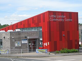
Little London is a residential area of Leeds in England, north of the city centre and Leeds Inner Ring Road. It is so called because in the 19th century it had fashionable housing and interesting architecture comparable to London. In the 1950s and '60s it became largely council housing and now consists of a mixture of high and low-rise flats and housing. The area falls within the Little London and Woodhouse ward of the City of Leeds Council. The area is divided into four estates; Lovell Park, Oatlands, Carlton and the Servias.

Lovell Park is an inner-city area of Leeds, West Yorkshire, England. The area falls within the Hyde Park and Woodhouse ward of the Leeds Metropolitan Council.
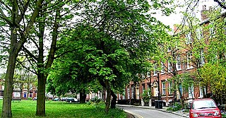
Blenheim is a small area of inner-city Leeds, West Yorkshire, England. It is situated north of the city centre between Little London, Lovell Park and Woodhouse and is generally made of early 20th century terraced housing. Blenheim falls within the Hyde Park and Woodhouse ward of Leeds City Council.

The Leeds Inner Ring Road is part-motorway and part-A roads in Leeds, West Yorkshire, England, which forms a ring road around the city centre. It has six different road numbers that are all sections of longer roads. Clockwise, the roads are the A58(M), a motorway section of the A58 road; the A64(M), part of the A64 road; the A61 between York Road and the M621; the M621 between junctions 4 and 2; and the A643 between the M621 and A58. The motorway section is in total is 2.5 miles (4.0 km) long and is subject to a 40 miles per hour (64 km/h) speed limit throughout.

The A64 is a major road in North and West Yorkshire, England, which links Leeds, York and Scarborough. The A64 starts as the A64(M) ring road motorway in Leeds, then towards York it becomes a high-quality dual carriageway until it is east of York, where it becomes a single carriageway for most of its route to Scarborough.

Hull Paragon Interchange is a transport interchange providing rail, bus and coach services located in the city centre of Kingston upon Hull, England. The G. T. Andrews-designed station was originally named Paragon Station, and together with the adjoining Station Hotel, it opened in 1847 as the new Hull terminus for the growing traffic of the York and North Midland (Y&NMR) leased to the Hull and Selby Railway (H&S). As well as trains to the west, the station was the terminus of the Y&NMR and H&S railway's Hull to Scarborough Line. From the 1860s the station also became the terminus of the Hull and Holderness and Hull and Hornsea railways.
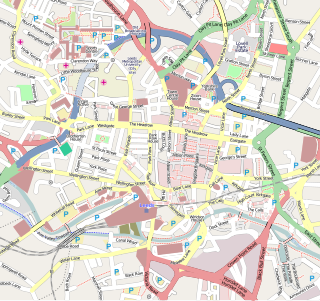
Leeds city centre is the central business district of Leeds, West Yorkshire, England. It is roughly bounded by the Inner Ring Road to the north and the River Aire to the south and can be divided into several quarters.

Richmond Hill is a district of Leeds, West Yorkshire, England. The district lies a mile to the east of the city centre between York Road, East End Park and Cross Green. The appropriate City of Leeds ward is Burmantofts and Richmond Hill.

The A638 is a major road in England. It runs between the A1 at Markham Moor, Nottinghamshire and Chain Bar Interchange – Junction 26 of the M62 motorway, south of Bradford in West Yorkshire.

Transport within Leeds consists of extensive road, bus and rail networks. The city has good rail and road links to the rest of the country. Leeds railway station is one of the busiest in Britain, and Leeds is connected to the national road network via the A1(M) motorway, M1 motorway and M62 motorway. The city is served by Leeds Bradford Airport.

The architecture of Leeds, a city and metropolitan borough in West Yorkshire, England, encompasses a wide range of architectural styles and notable buildings. As with most northern industrial centres, much of Leeds' prominent architecture is of the Victorian era. However, the City of Leeds also contains buildings from as early as the Middle Ages such as Kirkstall Abbey, one of Britain's best preserved ruined Cistercian monasteries, as well as examples of 20th century industrial architecture, particularly in the districts of Hunslet and Holbeck.
The Willson Group of artists was an English Quaker family of about seven landscape, portrait and caricature painters. Members included John Joseph Willson, his sister Hannah Willson, his wife Emilie Dorothy Hilliard, and their four children, Michael Anthony Hilliard Willson, twins Margaret Willson and E. Dorothy Willson, and Mary Hilliard Willson.


