Shepherd Neolithic

Last updated
Shepherd Neolithic
Shepherd Neolithic flint tools.jpg
Geographical range Lebanon
Period Epipaleolithic
Datescirca 10,200 B.C.E. — circa 8,800 B.C.E.
Type site Qaa, Maqne
Major sites Hermel, Kamouh el Hermel, Douris, Hermel, Kamouh el Hermel, Qalaat Tannour, Rayak North, Riha Station
Preceded by Natufian culture
Followed by Pre-Pottery Neolithic A
Lebanon adm location map.svg
Red pog.svg
Qaa
Map of Lebanon showing important sites that were occupied in the Shepherd Neolithic (clickable map)
A shepherd with sheep on a mountainside. Sheep were among the first animals to be domesticated by humankind; the domestication date is estimated to fall between nine and eleven thousand years ago in Mesopotamia.Henri Fleisch suggested that the Shepherd Neolithic industry could have been used by nomadic shepherds. Afghanistan 12.jpg
A shepherd with sheep on a mountainside. Sheep were among the first animals to be domesticated by humankind; the domestication date is estimated to fall between nine and eleven thousand years ago in Mesopotamia.Henri Fleisch suggested that the Shepherd Neolithic industry could have been used by nomadic shepherds.

Shepherd Neolithic is a name given by archaeologists to a style (or industry) of small flint tools from the Hermel plains in the north Beqaa Valley, Lebanon. [7] The Shepherd Neolithic industry has been insufficiently studied and was provisionally named based on a limited typology collected by Jesuit archaeologist "Père" Henri Fleisch. [8] Lorraine Copeland and Peter J. Wescombe suggested it was possibly "of quite late date". [8]

Contents

Characteristics

Shepherd Neolithic material can be found dispersed over a wide area of the north Beqaa Valley in low concentrations. M. Billaux and Henri Fleisch suggested that the flints were of a higher quality than the brittle flint in the nearby conglomerates indicating origin from elsewhere. Three groups of flint could be determined; light brown, red-brown and that varied but was usually grey-chocolate that was distinguished with a radiant "desert shine". Characteristics of the industry include smallness in size, commonly between 2.5 cm and 4 cm and frequently being quite thick, unlike geometric microliths. The small number of tools within the assemblage is another distinguishable characteristic, including short denticulated or notched blades, end scrapers, transverse racloirs on thin flakes and borers with strong points. They also display a lack of recognizable typology although Levallois technique was occasionally observed to have been used. They also show signs of having been heavily worked with cores being re-used and turned into scrapers. Fleisch suggested the industry was Epipaleolithic as it is evidently not Paleolithic, Mesolithic or even Pottery Neolithic. He further suggested that the industry could have been used by nomadic shepherds. [5] [6]

The relationship and dividing line between the related Heavy Neolithic zone of the south Beqaa Valley could also not be clearly defined but was suggested to be in the area around Douris and Qalaat Tannour. Not enough exploration had been carried out to conclude whether the bands of Neolithic surface sites continues south into the areas around Zahle and Rayak. [5]

Sites

The type sites of the Shepherd Neolithic are at Qaa and Maqne I, with other sites with Shepherd Neolithic finds include Douris, Hermel II, Hermel III, Kamouh el Hermel, Qalaat Tannour, Wadi Boura I and possibly at Rayak North, Riha Station and Serain.

Related Research Articles

<span class="mw-page-title-main">Hermel</span> Place in Baalbek-Hermel Governorate, Lebanon

Hermel is a town in Baalbek-Hermel Governorate, Lebanon. It is the capital of Hermel District. Hermel is home to a Lebanese Red Cross First Aid Center. Hermel's inhabitants are predominantly Shia Muslims.

<span class="mw-page-title-main">Qaa</span> Place in Baalbek-Hermel, Lebanon

Qaa, El Qaa, Al Qaa, Qaa Baalbek or Masharih al-Qaa is a town in Baalbek-Hermel Governorate, Lebanon. A 2010 report stated that population of the settlement was 500, all Lebanese Maronites

<span class="mw-page-title-main">Joub Jannine</span> Village in Lebanon

Joub Jannine is located in the Beqaa Valley in Lebanon.

<span class="mw-page-title-main">Riyaq</span> Town in Lebanon

Rayaq - Haouch Hala, also romanized Rayak, is a Lebanese town in the Beqaa Governorate near the city of Zahlé. In the early 20th century and up to 1975 and the outbreak of the civil war, it was Lebanon's most important railway center, where the 1.05-m Beirut–Damascus line met the standard-gauge line north to Baalbek, Homs, and Aleppo. It now has an air base and a hospital. Rayak Air Base was bombed by the Israeli Air Force during the 2006 Lebanon War. The landing strip was severely damaged as a result.

<span class="mw-page-title-main">Duris, Lebanon</span> Human settlement in Lebanon

Duris is a village located approximately 3 km (2 mi). southwest of Baalbek in the Bekaa Valley, Lebanon. It is the site of a 13th-century Muslim shrine and a necropolis from the late Roman Imperial period that is currently undergoing archaeological investigation.

<span class="mw-page-title-main">Kaukaba</span> Village in Nabatieh Governorate

Kaukaba, Kaukabet El-Arab or Kaukaba Station is a village in the Hasbaya District in the Nabatiye Governorate in southern Lebanon.

<span class="mw-page-title-main">Archaeology of Lebanon</span> Archaeology in Lebanon

Archaeology of Lebanon includes thousands of years of history ranging from Lower Palaeolithic, Phoenician, Roman, Arab, Ottoman, and Crusades periods.

<span class="mw-page-title-main">Qaraoun</span> Village in Beqaa Governorate, Lebanon

Qaraoun is a Lebanese village, 85 km from Beirut, known for its Lake Qaraoun in the Beqaa Valley formed by the El Wauroun Dam built in 1959. It is an ecologically fragile zone in the Western Beqaa District. The village lies about 800 m above sea level. The dam is located nearby on the Litani River.

<span class="mw-page-title-main">Heavy Neolithic</span> Style of large stone and flint tools

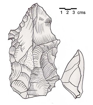
Heavy Neolithic is a style of large stone and flint tools associated primarily with the Qaraoun culture in the Beqaa Valley, Lebanon, dating to the Epipaleolithic or early Pre-Pottery Neolithic at the end of the Stone Age. The type site for the Qaraoun culture is Qaraoun II.

<span class="mw-page-title-main">Trihedral Neolithic</span>

Trihedral Neolithic is a name given by archaeologists to a style of striking spheroid and trihedral flint tools from the archaeological site of Joub Jannine II in the Beqaa Valley, Lebanon. The style appears to represent a highly specialized Neolithic industry. Little comment has been made of this industry.

<span class="mw-page-title-main">Qaraoun culture</span> Archaeological culture in Lebanon

The Qaraoun culture is a culture of the Lebanese Stone Age around Qaraoun in the Beqaa Valley. The Gigantolithic or Heavy Neolithic flint tool industry of this culture was recognized as a particular Neolithic variant of the Lebanese highlands by Henri Fleisch, who collected over one hundred flint tools within two hours on 2 September 1954 from the site. Fleisch discussed the discoveries with Alfred Rust and Dorothy Garrod, who confirmed the culture to have Neolithic elements. Garrod said that the Qaraoun culture "in the absence of all stratigraphical evidence may be regarded as mesolithic or proto-neolithic"..

Jebel Aabeby is an archaeological site approximately 2 kilometres (1.2 mi) southeast of Sidon, to the west of the road north to Qraye in Lebanon. The site is on a hill where a number of Cedar trees surround the Mar Elias monastery on the western side of the summit. A Heavy Neolithic assemblage of flint tools made by the Qaraoun culture was collected from some Olive terraces bordering on the road and from an area above them that was disturbed in the construction of a trackway. The flint was of a brown, Nummulitic, Eocene type, some having been patinated to white while others were found fresh. Several broad blades were found along with heavy scrapers on flakes, massive cores, rabots, racloirs and a few smaller scrapers. The material now stored in the Museum of Lebanese Prehistory was studied by Henri Fleisch, who concluded that the site was likely used as a prehistoric factory.

Ourrouar is a series of archaeological sites approximately 8.5 kilometres (5.3 mi) south southeast of Beirut, Lebanon. It is near Hadeth south on the north side of the Nahr Ghedir.

<span class="mw-page-title-main">Baidar ech Chamout</span> Village in Beqaa Governorate, Lebanon

Baidar ech Chamout, Baïdar ech Chamoût or Beidar Chamout is a small village located 3 kilometres (1.9 mi) northeast of Machgara in the Western Beqaa District of Beqaa Governorate in Lebanon.

<span class="mw-page-title-main">Wadi Yaroun</span> Wadi in Lebanon

Wadi Yaroun, Wadi Yarun, Wadi Jarun, Wadi Hanine, Jarun or Jareon is a wadi located south of Ain Ebel in the Bint Jbeil District of Nabatieh Governorate in Lebanon. After it reaches Yaroun it is called the Wadi Nahle or Wadi Nalesh and after reaching Debel it is called the Wadi Ayun et Tannour.

<span class="mw-page-title-main">Flaoui</span> Village in Baalbek-Hermel, Lebanon

Flaoui or Fleywe or Flaoueh is a small village located 17 kilometres (11 mi) northwest of Baalbek, Lebanon in Baalbek District, Baalbek-Hermel Governorate, Lebanon. It is located near the north–south road that runs from Bodai to Chlifa.

<span class="mw-page-title-main">Maqne</span> Town in Baalbek-Hermel, Lebanon

Maqne or Maakne is a town and municipality in Baalbek District, Baalbek-Hermel Governorate, Lebanon.

<span class="mw-page-title-main">Qalaat Tannour</span> Archaeological site in Lebanon

Qalaat Tannour is a Shepherd Neolithic archaeological site located halfway between Britel and Haour Taala, 12 kilometres (7.5 mi) southwest of Baalbek in the Baalbek District of the Beqaa Governorate in Lebanon.

Riha Station is a hill with a thin, occupational Shepherd Neolithic archaeological site located between the villages of Chaat and Knaisse, 14 kilometres (8.7 mi) northwest of Baalbek in Lebanon.

Saraain El Faouqa is a village located 6 kilometres (3.7 mi) northeast of Rayak in Baalbek District, Baalbek-Hermel Governorate, Lebanon. Most of its inhabitants Shia Muslims and a minority are Maronites.

References

  1. Ensminger
  2. Weaver
  3. Simmons & Ekarius
  4. Krebs, Robert E. & Carolyn A. (2003). Groundbreaking Scientific Experiments, Inventions & Discoveries of the Ancient World. Westport, CT: Greenwood Press. ISBN   0-313-31342-3.
  5. 1 2 3 L. Copeland; P. Wescombe (1966). Inventory of Stone-Age Sites in Lebanon: North, South and East-Central Lebanon,. Impr. Catholique. Retrieved 1 January 2012.
  6. 1 2 Fleisch, Henri., Notes de Préhistoire Libanaise : 1) Ard es Saoude. 2) La Bekaa Nord. 3) Un polissoir en plein air. BSPF, vol. 63.
  7. Fleisch, Henri., Les industries lithiques récentes de la Békaa, République Libanaise, Acts of the 6th C.I.S.E.A., vol. XI, no. 1. Paris, 1960.
  8. 1 2 Lorraine Copeland; P. Wescombe (1965). Inventory of Stone-Age sites in Lebanon, p. 43. Imprimerie Catholique. Retrieved 21 July 2011.[ permanent dead link ]