
Ocean County is a county located along the Jersey Shore in the south-central portion of the U.S. state of New Jersey, and the southernmost county in the New York metropolitan area. It is the only U.S. county named Ocean. The county borders the Atlantic Ocean on the east and in terms of total area is the state's largest county. Its county seat is Toms River.

Monmouth County is a county located on the northern part of the Jersey Shore in the U.S. state of New Jersey. The county is part of the New York metropolitan area. As of the 2020 United States census, the county was the state's fifth-most-populous county with a population of 643,615, its highest decennial count ever and an increase of 13,235 (+2.1%) from the 2010 census count of 630,380, which in turn reflected an increase of 15,079 from 615,301 at the 2000 census. As of 2010, the county fell to the fifth-most populous county in the state, having been surpassed by Hudson County. Monmouth County's geographic area comprises 30% water.

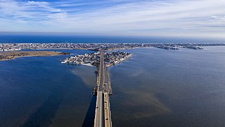
Route 36 is a state highway in Monmouth County, New Jersey, United States. The 24.40-mile (39.27 km) long route, shaped as a backwards C, begins at an intersection with the Garden State Parkway and County Route 51 on the border of Tinton Falls and Eatontown and runs east to Long Branch. From Long Branch, the route follows the Atlantic Ocean north to Sea Bright and turns west, running to the south of the Raritan Bay. Route 36 ends in Keyport at an interchange with the Garden State Parkway and Route 35. It varies in width from a six-lane divided highway to a two-lane undivided road. The route is signed east–west between Eatontown and Long Branch and north–south between Long Branch and Keyport.

Highlands is a borough in northern Monmouth County, in the U.S. state of New Jersey. An historic waterfront community located on the Raritan Bay within the Raritan Valley region, this scenic borough is a commuter town of New York City in the New York metropolitan area. As of the 2020 United States census, the borough's population was 4,621, a decrease of 384 (−7.7%) from the 2010 census count of 5,005, which in turn reflected a decline of 92 (−1.8%) from the 5,097 counted in the 2000 census. The eastern part of the town is on a high bluff that overlooks Sandy Hook Bay, the entrance to New York Harbor, and the Atlantic Ocean, from which the borough derives its name. Atop this bluff are the Navesink Twin Lights.

Sea Bright is a borough situated on the Jersey Shore, within Monmouth County, in the U.S. state of New Jersey. As of the 2020 United States census, the borough's population was 1,449, an increase of 37 (+2.6%) from the 2010 census count of 1,412, which in turn had reflected a decline of 406 (−22.3%) from the 1,818 counted in the 2000 census.
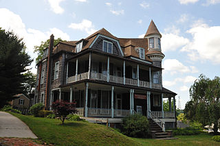
Atlantic Highlands is a borough in Monmouth County in the U.S. state of New Jersey, in the Bayshore Region. As of the 2020 United States census, the borough's population was 4,414, an increase of 29 (+0.7%) from the 2010 census count of 4,385, which in turn reflected a decline of 320 (−6.8%) from the 4,705 in the 2000 census.

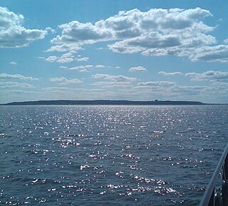
Sandy Hook is a barrier spit in Middletown Township, Monmouth County, New Jersey, United States. The barrier spit, approximately 6 miles (9.7 km) in length and varying from 0.1 to 1.0 mile wide, is located at the north end of the Jersey Shore. It encloses the southern entrance of Lower New York Bay south of New York City, protecting it from the open waters of the Atlantic Ocean to the east.
The Jersey Shore is the coastal region of the U.S. state of New Jersey. Geographically, the term encompasses about 141 miles (227 km) of oceanfront bordering the Atlantic Ocean, from Perth Amboy in the north to Cape May Point in the south. The region includes Middlesex, Monmouth, Ocean, Atlantic, and Cape May counties, which are in the central and southern parts of the state. Located in the center of the Northeast Megalopolis, the northern half of the shore region is part of the New York metropolitan area, while the southern half of the shore region is part of the Philadelphia metropolitan area, also known as the Delaware Valley. The Jersey Shore hosts the highest concentration of oceanside boardwalks in the United States.

North Jersey comprises the northern portions of the U.S. state of New Jersey between the upper Delaware River and the Atlantic Ocean. As a distinct toponym, North Jersey is a colloquial one rather than an administrative one, reflecting geographical and perceived cultural and other differences between it and the southern part of the state.

Central Jersey, or Central New Jersey, is the middle region of the U.S. state of New Jersey. The designation Central Jersey is a distinct administrative toponym. While the State of New Jersey is often divided into North Jersey and South Jersey, many residents recognize Central Jersey as a distinct entity. Governor Phil Murphy signed legislation designating Central Jersey as an official tourism region on August 23, 2023.
New Jersey's 6th congressional district is represented by Democrat Frank Pallone, who has served the district in Congress since 1993. The district includes the northern and eastern portions of Middlesex County and the coastal areas of Monmouth County, including towns along the Raritan Bay.
New Jersey's 4th congressional district is a congressional district that stretches along the New Jersey Shore. It has been represented by Republican Chris Smith since 1981, the second-longest currently serving member of the US House of Representatives and the longest serving member of Congress from New Jersey in history.
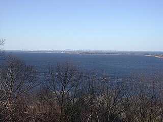
Mount Mitchill in Atlantic Highlands, Monmouth County, New Jersey, United States, at 266 feet, is the highest headland of the United States east coast south of Maine. It has a panoramic view of Raritan Bay, New York City and Sandy Hook and is near the Twin Lights Lighthouse in Highlands. It is the location of the Monmouth County 9-11 Memorial. It was named after Samuel Latham Mitchill, who determined the height of the hill.

The Raritan Bayshore is a region in central sections in the state of New Jersey. It is the area around Raritan Bay from The Amboys to Sandy Hook, in Middlesex and Monmouth counties, including the towns of Perth Amboy, South Amboy, Sayreville, Old Bridge, Matawan, Aberdeen, Keyport, Union Beach, Hazlet, Keansburg, Middletown, Atlantic Highlands, and Highlands. It is the northernmost part of the Jersey Shore, located just south of New York City. At Keansburg is a traditional amusement park while at Sandy Hook are found ocean beaches. The Sadowski Parkway beach area in Perth Amboy, which lies at the mouth of the Raritan River, was deemed the "Riviera of New Jersey" by local government. In recent years many of the beaches on the Bayshore area have been rediscovered and upgraded.
The Barnegat Peninsula, also known as the Island Beach Peninsula or Barnegat Bay Island and colloquially as "the barrier island", is a 20-mile (32 km) long, narrow barrier peninsula located on the Jersey Shore in Ocean County, New Jersey, United States, that divides the Barnegat Bay from the Atlantic Ocean. It is a vacation destination and summer colony area and is heavily dependent on tourism, real estate and fishing.

New Jersey is a state within the United States of America that lies on the north eastern edge of the North American continent. It shares a land border with the state of New York along the north, ratified by both states after the New York – New Jersey Line War, which is its only straight line border. New Jersey is slightly larger than the country of Kuwait.
The New Jersey Coastal Heritage Trail Route extends along eastern and southern coast of New Jersey for nearly 300 miles. It travels along the Raritan Bay from Perth Amboy to Sandy Hook, along Jersey Shore at the Atlantic Ocean to Cape May, and along the Delaware Bay to the Delaware Memorial Bridge. The trail encompasses a variety of New Jersey state parks along with facilities under the jurisdiction of the National Park Service.

The Southern Shore Region is located in the South Jersey region of New Jersey. It is one of six tourism regions established by the New Jersey State Department of Tourism, the others are the Gateway Region, Greater Atlantic City, the Delaware River Region, the Shore Region. and the Skylands Region. The area includes Cape May County and Cumberland County. The coast is along the Atlantic Ocean and Delaware Bay, while the inland areas are part of the New Jersey Pine Barrens.
The Navesink Highlands, sometimes referred to as the Highlands of Navesink and also known as the Atlantic Highlands, is a range of low hills and upland areas located along the United States Atlantic coast in New Jersey. The hills of the Highlands reach over 350 feet (107 m) in elevation, reportedly reaching a maximum elevation of 391 feet at Crawford Hill, which is the highest point in Monmouth County. The seaward front of the Navesink Highlands constitute the highest headlands along the United States east coast south of Maine, with the highest point of the headlands reaching an elevation of 266 feet at Mount Mitchill.
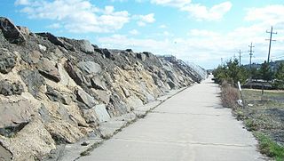
The Sea Bright–Monmouth Beach Seawall is a seawall located along the Jersey Shore in the Monmouth County, New Jersey towns of Sea Bright and Monmouth Beach. It roughly runs north-south direction along 4.7 miles (7.6 km) of the barrier spit of land along the lower Sandy Hook peninsula between the Atlantic Ocean and the Shrewsbury River estuary. The use of seawalls, groins, jetties, bulkheads, revetment, and beach nourishment since the late 1800s has made the stretch of coast one of the most heavily engineered sections of ocean shorefront in the world.
