Shotley Bridge

Last updated

Shotley Bridge
St Cuthbert's church, Benfieldside geograph-3206469-by-Dave-Kelly.jpg
St Cuthbert's Church
Durham UK location map.svg
Red pog.svg
Shotley Bridge
Location within County Durham
Population27,394 
OS grid reference NZ108511
Unitary authority
Ceremonial county
Region
Country England
Sovereign state United Kingdom
Post town CONSETT
Postcode district DH8
Dialling code 01207
Police Durham
Fire County Durham and Darlington
Ambulance North East
UK Parliament
List of places
UK
England
County Durham
54°52′N1°52′W / 54.87°N 1.86°W / 54.87; -1.86

Shotley Bridge is a village, adjoining the town of Consett to the south in County Durham, England, 15 miles northwest of Durham City.

Contents

It is located on the A694 road starting from Consett and Blackhill to the south, then continuing north east to East Law, Ebchester and onward to Swalwell within the borough of Gateshead. Shotley Bridge sits beside the River Derwent which is crossed by the bridge giving the name. It was once the heart of Britain's swordmaking industry.

History

There were formerly several fords over the River Derwent near this place and in medieval times a wooden bridge. The present stone bridge was widened in 1820, but its original date is not known. [1] The bed of the river itself was the source of stone for millstones, and licences for this are recorded at "Shotley Brig" in 1356. [1]

A water-powered corn mill was established in the 14th century, later replaced by a steam-powered one which was sold to the Derwent Co-operative Flour Mill Society Ltd in 1872, and continued until its closure in 1920. [1] A paper mill was established in 1788 (the first in the north of England) and greatly expanded with mechanization so that in 1894 it had 300 hands (half being girls) and was a major factor in the expansion of the village. However it closed in 1905. [1]

A well near the village had unpleasant tasting water rumoured to be effective in curing disease and thus known as the "Hally Well" (hally = healthy, like hale). In 1828 a local entrepreneur John Richardson used this as the basis for a Spa which enjoyed considerable success with the well-to-do, becoming less fashionable as industry grew in nearby towns, but being remade as a playground for workers. [1] [2] [3]

It was during the Victorian era that much of the town's architecture was constructed, including some grand residences and many listed buildings, so that by 1898 it had much of its present form. [2] and a population of over 1000. [1] This also saw the advent of Shotley Bridge railway station (closed 1952) and a gasworks which closed in the 1960s, [2] electric lighting having replaced gas lamps from 1950. [1] The closure of the steelworks at Consett in 1980 caused an economic decline, however since then the village has become more popular. [2]

Swordmaking

In the 17th century a group of swordmakers (Oley, Vooz, Molle and Bertram) from Solingen in Germany settled in Shotley Bridge, in order to escape religious persecution. [1] [4] Shotley Bridge was chosen because of the quality of the ironstone in the area and the softness and fast flow of the River Derwent. [1]

The Oley family were makers of the highest quality swords, rivalling those of Toledo, by using Damascus steel, [1] [4] in great demand during the Napoleonic Wars. They became very wealthy. [4] Their steel production facility was one of the earliest factories for manufacture of steel. The Oley family were involved in the formation of the Consett Iron Company. [1] New weapons and industrialization reduced demand for swords so they diversified into other types of cutlery, but could not compete with Sheffield, [1] [4] and the sword works closed in 1840. [2] Some moved to Birmingham and their business eventually became part of Wilkinson Sword. [2]

Evidence of this industry includes grooves in the stones of the river, [1] the fine house inscribed "Cutlers Hall, 1767, William Oley" [1] [4] and the name of the public house "The Crown and Crossed Swords". [2] [4] Before the last remaining cottages occupied by the swordmakers were demolished, there was an inscription over the door of the Oley house on Wood Street reading "Das Herren segen machet reich ohn alle Sorg wenn Du zugleich in deinem Stand treu und fleissig bist und tuest alle vas die befolen ist". This means "The blessing of the Lord makes rich without care, so long as you are industrious in your vocation and do what is ordered you". [1]

Places of Worship

The first mention of a chapel at Shotley is in 1165. [2] This is the site of the (now disused) Anglican parish church, St Andrew's, Shotley, which is high on a hill above the town. It is an eighteenth-century Grade II listed building rebuilt in 1892 because of subsidence due to coal workings below. [5] The current parish church is that of St John at Snod's Edge, also Grade II listed, dating from 1837 when it was founded as a chapel outpost of St Andrew's. [6] There is a Roman Catholic Church, Our Lady of the Rosary (1952), [1] and an Anglican Church, St Cuthbert's (1850), designed by John Dobson, in the Benfieldside area south-east of the main town. The Methodist Church was built in 1894, and closed in 2014. [7]

Shotley Bridge Hospital

Shotley Bridge Hospital originated with the acquisition of the Whinney House Estate in 1912. [8] The site was initially used as a tuberculosis hospital but served as a facility for the care of people with mental problems being known as "Shotley Bridge Mental Defectives Colony" from 1927 to 1940, [9] when it was converted to an Emergency Hospital to cope with the Second World War, particularly providing plastic surgery, [10] [11] becoming a general hospital in 1948. [9] [10] Although it was once one of the largest of the Northern Region [1] services have been transferred elsewhere, most of the buildings demolished for housing and the current hospital is a much smaller group of modern buildings operating as a community hospital. [12]

Other buildings

In the Victorian boom time, the village was often referred to as a town [1] with such enthusiasm that a Town Hall was actually built in 1860. [1] [2] [3] It is one of several buildings from this period in Neogothic style. Another is Shotley Hall by Edward Robson. There are other grand houses from this period which are some of the many listed buildings in the area. [2] While the Wesleyan Chapel was demolished, its Sunday School remains and is now the Village Hall. [1] [2] The clergyman's house is now known as The Manse. [2] The 1876 Temperance Hall is now the Assembly Rooms. [2] The Crown and Crossed Swords hotel includes what was once a separate establishment, The Commercial. [2]

The King's Head sits opposite the Crown and Crossed Swords.

Other Attractions

There are a couple of footpaths of note.

One heads west and away from the A694 from close to the King's Head, crossing the River Derwent then continuing along the north bank of the Derwent to Allensford and the A68. The path continues beyond this on the south side of the Derwent to Wharnley Burn Waterfall.

The other can be accessed up a set of small stone stairs from the road on crossing the bridge across the Derwent to the right (east). This path leads eventually to the Northumberland hamlet of Newlands. This path has the nickname The Way of the Waterfalls due to there being one small waterfall on Mere Burn and two on Small Burn close to the Newlands end of the path.

The Derwent Walk is accessible from Blackhill to the south and from the road to Medomsley heading away from the Crown and Crossed Swords pub and A694 to the east.

Notable people

Related Research Articles

<span class="mw-page-title-main">River Derwent, North East England</span> River in Durham and Northumberland, England

The River Derwent is a river which flows between the historic county boundaries of Durham and Northumberland in the north east of England. It broadens into the Derwent Reservoir, west of Consett. The Derwent is a tributary of the River Tyne, which it joins near the MetroCentre near Gateshead. The river flows for 35 miles from its origin, where two streams, Beldon Burn and Nookton Burn meet approximately a mile west of Blanchland, to Derwenthaugh where it flows into the River Tyne. On its journey, the river flows through places such as Allensford, Shotley Bridge, Blackhall Mill and Rowlands Gill. The Derwent Walk Country Park at Rowlands Gill is named after the river.

<span class="mw-page-title-main">Derwentside</span> Former local government area in Co.Durham, England

Derwentside was, from 1974 to 2009, a local government district in County Durham, England.

<span class="mw-page-title-main">Consett</span> Town in County Durham, England

Consett is a town in the County Durham district, in the ceremonial county of Durham, England, about 14 miles (23 km) south-west of Newcastle upon Tyne. It had a population of 27,394 in 2001 and an estimate of 25,812 in 2019.

<span class="mw-page-title-main">Benfieldside</span>

Benfieldside is a parish in County Durham, in England. Although not a village in its own right, it is signposted and locally known. From a governance point of view it is a ward of Consett with a population taken at the 2011 census of 6,637. The name 'Benfieldside' survives in Benfieldside Road, a school of that name, the local tennis club and the church. Its post office no longer exists, though one remains in the village of Shotley Bridge. The Parish Church is dedicated to St. Cuthbert and is situated on Church Bank. The area is situated directly to the north of Consett, to which it is effectively attached.

Burnopfield is a village in County Durham, in England. It is situated north of Stanley and Annfield Plain, close to the River Derwent and is 564 feet above sea level. There are around 4,553 inhabitants in Burnopfield. It is located 7 miles from Newcastle upon Tyne and 15 miles from Durham.

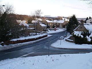
East Law is a small village in County Durham, England. It is situated on the A694 to the north of Consett and north east of Shotley Bridge. It is located south west of Ebchester, of which it can be considered an outlying part.

<span class="mw-page-title-main">Ebchester</span> Human settlement in County Durham, England

Ebchester is a village in County Durham, England. It is situated to the north of Consett and to the south east of Whittonstall and the hamlet of Newlands. The village sits at the intersection of the A694, which runs from Consett to Swalwell, and the B6309, which connects the A696 north of Belsay and runs through Whittonstall and Newlands, across the River Derwent, up Chare Bank then through Ebchester itself then past Medomsley into the A691 immediately south of the village of Leadgate.

<span class="mw-page-title-main">Medomsley</span> Human settlement in England

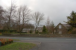
Medomsley is a village in County Durham, England. It is about 2 miles (3 km) northeast of the centre of Consett, 1+12 miles (2 km) south of Hamsterley and 1 mile (2 km) southeast of Ebchester along the B6309. Leadgate lies a further mile to the south east.

Rowlands Gill is a village on the north bank of the River Derwent, in the Metropolitan Borough of Gateshead, Tyne and Wear, England. The Gibside Estate is near the town.

The Derwent Valley Railway was a branch railway in County Durham, England. Built by the North Eastern Railway, it ran from Swalwell to Blackhill via five intermediate stations, and onwards to Consett.

<span class="mw-page-title-main">Consett railway station</span> Former railway station in England

Consett was a railway station built by the North Eastern Railway on the route of the Stanhope and Tyne Railway, in County Durham, North East England. It served the industrial town of Consett, which was best known for its steelworks.

Crook railway station served the town of Crook, County Durham, England. It was located on the Bishop Auckland and Weardale Railway line from Bishop Auckland to Blackhill between Wear Valley Junction and Tow Law, 17 miles (27 km) north west of Darlington.

Shotley Grove is a small settlement on the river Derwent, about 1 mile upstream of Shotley Bridge in County Durham, England.

<span class="mw-page-title-main">Blackhill railway station</span> Disused railway station in Blackhill, Consett

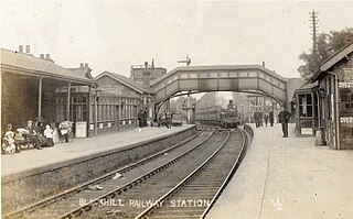
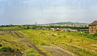
Blackhill railway station served the village of Blackhill, County Durham, England from 1867 to 1955 on the Derwent Valley Line.

<span class="mw-page-title-main">Shotley Park</span>

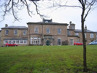
Shotley Park is a former stately home and estate near the town of Shotley Bridge in County Durham, England. It is a listed building with grade II.

<span class="mw-page-title-main">Shotley Bridge Hospital</span> Hospital in County Durham, England

Shotley Bridge Hospital is a healthcare facility in Shotley Bridge, County Durham, England. It is managed by the County Durham and Darlington NHS Foundation Trust.

John Wilson Walton-Wilson, born John Wilson Walton, was an English architect who designed Anglican churches in the Early English style. His change of name was a condition by which he inherited Shotley Hall and the Wilson family coat of arms from his uncle Thomas Wilson. He is known for his design of St Augustine's Church, Alston, Cumbria, and for his collaboration with the sculptor Robert Beall in his renovation of St Mary's Church, Nun Monkton North Riding of Yorkshire.

<span class="mw-page-title-main">Newlands, Northumberland</span> A hamlet in Northumberland, England

Newlands is a hamlet and former civil parish, now in the parish of Shotley Low Quarter, in the county of Northumberland, England. It is north of Ebchester and south of Whittonstall on the B6309, which follows the route of the ancient Roman road of Watling Street. It is situated north of the River Derwent. The nearest large settlement is Consett to the south west. In 1951 the parish had a population of 71.

References

  1. 1 2 3 4 5 6 7 8 9 10 11 12 13 14 15 16 17 18 19 20 Chatt, Alice. The Story of our Village. Shotley Bridge Women's Institute.
  2. 1 2 3 4 5 6 7 8 9 10 11 12 13 14 "Shotley Bridge Conservation Area Appraisal" (PDF). www.durham.gov.uk. Durham County Council. 2009. Retrieved 23 July 2017.
  3. 1 2 "Parson left enduring mark on Victorian spa town". Hexham Courant. 6 August 2010. Retrieved 24 July 2017.
  4. 1 2 3 4 5 6 Harrison, Brian (2 February 2013). "The German Sword Makers of Shotley Bridge". Consett Magazine. Retrieved 23 July 2017.
  5. Ross, David. "Shotley, St Andrew's Church". Britain Express. Retrieved 23 July 2017.
  6. "St. John's Church Shotley". www.shotleystjohn.org.uk. Retrieved 23 July 2017.
  7. "Congregation to bid farewell to Shotley Bridge church after 120 years". The Northern Echo. 23 April 2014. Retrieved 23 July 2017.
  8. "Shotley Bridge Hospital". Shotley Bridge Village Trust. Retrieved 27 December 2019.
  9. 1 2 "Details: Shotley Bridge General Hospital, Consett". The National Archives. Retrieved 24 July 2014.
  10. 1 2 "Shotley Bridge Hospital". Domesday Reloaded. BBC. 1986. Archived from the original on 18 March 2012. Retrieved 24 July 2017.
  11. Bell, R C (July 1986). "A brief history of the plastic surgery unit based on shotley bridge general hospital". British Journal of Plastic Surgery. 39 (3): 422–431. doi: 10.1016/0007-1226(86)90060-3 . PMID   3524722 . Retrieved 24 July 2017.
  12. "Shotley Bridge Community Hospital". www.cddft.nhs.uk. 2010. Retrieved 24 July 2017.
  13. Brown, Alex (3 December 2006). "Double ton has family rejoicing ... after a nap". Sydney Morning Herald online edition. Retrieved 2 December 2006.

Further reading

Commons-logo.svg Media related to Shotley Bridge at Wikimedia Commons