Silver Springs Shores, Florida

Last updated

Silver Springs Shores, Florida
Marion County Florida Incorporated and Unincorporated areas Silver Springs Shores Highlighted.svg
Location in Marion County and the state of Florida
Coordinates: 29°6′5″N82°0′45″W / 29.10139°N 82.01250°W / 29.10139; -82.01250
Country Flag of the United States.svg  United States
State Flag of Florida.svg  Florida
County   Marion
Area
[1]
  Total15.15 sq mi (39.24 km2)
  Land14.93 sq mi (38.68 km2)
  Water0.21 sq mi (0.56 km2)
Elevation
95 ft (29 m)
Population
 (2020) [2]
  Total24,846
  Density1,663.72/sq mi (642.37/km2)
Time zone UTC-5 (Eastern (EST))
  Summer (DST) UTC-4 (EDT)
ZIP Code
34472 (Ocala)
FIPS code 12-66175 [3]
GNIS feature ID0306947 [4]

Silver Springs Shores is a census-designated place (CDP) in Marion County, Florida, United States. The population was 24,846 at the 2020 census, up from 6,539 at the 2010 census. [2] It is part of the Ocala, Florida Metropolitan Statistical Area.

Contents

The community, often referred to by locals as simply "the shores", serves primarily as a bedroom community for Ocala. It is the largest community in southeast Marion County.

Geography

Silver Springs Shores is located at 29°6′5″N82°0′45″W / 29.10139°N 82.01250°W / 29.10139; -82.01250 (29.101279, -82.012439). [5] It is 10 miles (16 km) southeast of the center of Ocala, the county seat.

According to the United States Census Bureau, the CDP has a total area of 15.1 square miles (39 km2), of which 14.9 square miles (39 km2) are land and 0.2 square miles (0.5 km2), or 1.42%, are water. [1]

Demographics

Historical population
CensusPop.Note
1980 3,983
1990 6,42161.2%
2000 6,5542.1%
2010 6,539−0.2%
2020 24,846280.0%
U.S. Decennial Census [6]

As of the census [3] of 2000, there were 6,690 people, 2,846 households, and 1,886 families residing in the CDP. The population density was 1,401.2 inhabitants per square mile (541.0/km2). There were 3,372 housing units at an average density of 706.3 per square mile (272.7/km2). The racial makeup of the CDP was 63.36% White, 28.45% African American, 0.31% Native American, 1.08% Asian, 3.35% from other races, and 3.45% from two or more races. Hispanic or Latino of any race were 12.08% of the population.

There were 2,846 households, out of which 24.3% had children under the age of 18 living with them, 48.1% were married couples living together, 14.8% had a female householder with no husband present, and 33.7% were non-families. 29.0% of all households were made up of individuals, and 19.5% had someone living alone who was 65 years of age or older. The average household size was 2.34 and the average family size was 2.87.

In the CDP, the population was spread out, with 23.9% under the age of 18, 5.9% from 18 to 24, 22.2% from 25 to 44, 19.0% from 45 to 64, and 29.1% who were 65 years of age or older. The median age was 43 years. For every 100 females, there were 80.5 males. For every 100 females age 18 and over, there were 76.6 males.

The median income for a household in the CDP was $26,493, and the median income for a family was $30,723. Males had a median income of $24,798 versus $18,279 for females. The per capita income for the CDP was $13,884. About 8.9% of families and 12.0% of the population were below the poverty line, including 18.5% of those under age 18 and 9.7% of those age 65 or over.

Schools

Most elementary-level students are served by Greenway Elementary and Emerald Shores Elementary schools; most middle school students attend Lake Weir Middle School, with the exception of the far western part of the community attending Fort King Middle School in Ocala. Most high school students attend Lake Weir High School which is located on Oak Road, with the remainder of the students in the far western part of the community attending Forest High School

Related Research Articles

<span class="mw-page-title-main">Black Diamond, Florida</span> Census-designated place in Florida, US

Black Diamond is a census-designated place (CDP) in Citrus County, Florida, United States. The population was 1,101 at the 2010 census, up from 694 in 2000.

<span class="mw-page-title-main">Citrus Hills, Florida</span> Census-designated place in Florida, US

Citrus Hills is a census-designated place (CDP) in Citrus County, Florida, United States. The population was 7,470 at the 2010 census, up from 4,029 in 2000.

<span class="mw-page-title-main">Hernando, Florida</span> Census-designated place in Florida, US

Hernando is a census-designated place in Citrus County, Florida, United States. The population was 9,054 at the 2010 census. At one time it was a city but it was disincorporated in the 1970s.

<span class="mw-page-title-main">Lecanto, Florida</span> Census-designated place in Florida, US

Lecanto is an unincorporated community and census-designated place (CDP) in Citrus County, Florida, United States. As of the 2010 census it had a population of 5,882, up from 5,161 in 2000. It is home to several county government facilities such as the Citrus County Sheriff's Office and the Citrus Campus of the College of Central Florida.

<span class="mw-page-title-main">Citrus Park, Florida</span> Census-designated place in Florida, United States

Citrus Park is an unincorporated census-designated place in Hillsborough County, Florida, United States. The population was 28,178 at the 2020 census, up from 24,252 at the 2010 census.

<span class="mw-page-title-main">East Lake-Orient Park, Florida</span> Census-designated place in Florida, United States

East Lake-Orient Park is an unincorporated census-designated place in Hillsborough County, Florida, United States. The population was 22,753 at the 2010 census, up from 5,703 at the 2000 census following an expansion of its borders. The area is the home of the Florida State Fairgrounds, which hosts the Florida State Fair in mid-February of each year. It was previously home to East Lake Square Mall. The ZIP code for East Lake-Orient Park is 33610 and 33619.

<span class="mw-page-title-main">Keystone, Florida</span> Census-designated place in Florida, United States

Keystone is an unincorporated census-designated place in Hillsborough County, Florida, United States. The Keystone area was first settled in the middle 1800s by the W.M. Mobley Family who migrated from Savannah, Georgia. The region has evolved from citrus and farming into a rural retreat of many lake homes and ranches. The population was 24,039 at the 2010 census, up from 14,627 at the 2000 census. The ZIP Codes encompassing the CDP area are 33556 and 33558.

<span class="mw-page-title-main">Lake Magdalene, Florida</span> Census-designated place in Florida, United States

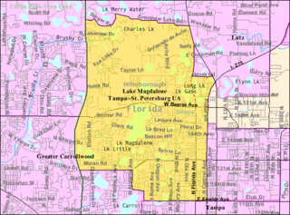
Lake Magdalene is a census-designated place (CDP) in Hillsborough County, Florida, United States. It is part of the Tampa Bay area. The population was 30,742 at the 2020 census.

<span class="mw-page-title-main">Mango, Florida</span> Census-designated place in Florida, United States

Mango is a census-designated place (CDP) in Hillsborough County, Florida, United States. The population was 12,699 at 2020 census, up from the 11,313 at the 2010 census.

<span class="mw-page-title-main">Thonotosassa, Florida</span> Census-designated place in Florida, United States

Thonotosassa is a census-designated place (CDP) in Hillsborough County, Florida, United States. The population was 15,238 at the 2020 census, up from 13,014 at the 2010 census.

<span class="mw-page-title-main">Paisley, Florida</span> Census-designated place in Florida

Paisley is an unincorporated community and census-designated place (CDP) in Lake County, Florida, United States. The population was 818 at the 2010 census, up from 734 at the 2000 census. It is part of the Orlando–Kissimmee Metropolitan Statistical Area.

<span class="mw-page-title-main">Matlacha Isles-Matlacha Shores, Florida</span> Census-designated place in Florida, United States

Matlacha Isles-Matlacha Shores is an unincorporated community and census-designated place (CDP) in Lee County, Florida, United States. The population was 227 at the 2020 census, down from 229 at the 2010 census. It is part of the Cape Coral-Fort Myers, Florida Metropolitan Statistical Area.

<span class="mw-page-title-main">Naranja, Florida</span> Census-designated place in Florida

Naranja is an unincorporated community and census-designated place (CDP) in Miami-Dade County, Florida, United States. Many orange groves were once located in this area, so the community name came from the Spanish word for orange, naranja, though the pronunciation among the local residents is "Na-Ran-Jah". Naranja was also a stop for the Florida East Coast Railroad that once ran through this area. It is part of the Miami metropolitan area of South Florida. The population was 13,509 at the 2020 census, up from 8,303 in 2010.

<span class="mw-page-title-main">Palm Springs North, Florida</span> Census-designated place in Florida

Palm Springs North is an unincorporated community and census-designated place (CDP) in Miami-Dade County, Florida, United States. It is part of the Miami metropolitan area of South Florida. The population was 5,030 at the 2020 census.

<span class="mw-page-title-main">The Hammocks, Florida</span> Census-designated place in Florida

The Hammocks is a planned community and census-designated place in Miami-Dade County, Florida, United States. It is part of the Miami metropolitan area of South Florida. The population was 59,480 at the 2020 census, up from 51,003 in 2010.

<span class="mw-page-title-main">Trinity, Florida</span> CDP in Florida, United States

Trinity is a census-designated place (CDP) in Pasco County, Florida, United States. The population was 10,907 in 2010, according to the most recent census. The Trinity Community is named after Trinity College of Florida, a Bible college founded in 1932, when it relocated to the first occupied site in the communities developed by James Gills in the late 1980s. The main plaza is found near the high school, known as Mitchell Ranch Plaza. Trinity is located at the junction where Pasco, Hillsborough and Pinellas Counties meet. The community of Longleaf is located in Trinity and it is believed that the “Welcome Plank” originated in Longleaf.

<span class="mw-page-title-main">East Lake, Pinellas County, Florida</span> Census-designated place in Florida, United States

East Lake is a census-designated place (CDP) in Pinellas County, Florida, United States. It was one of the last areas in the densely populated county to develop and often confused with East Lake in neighboring Hillsborough County. The population was 32,344 at the 2020 census.

<span class="mw-page-title-main">Lake Shore, Maryland</span> Census-designated place in Maryland, United States

Lake Shore is a census-designated place and unincorporated community in Anne Arundel County, Maryland, United States, located east of Pasadena. The population of Lake Shore was 19,477 at the 2010 census.

<span class="mw-page-title-main">Pine Ridge, Citrus County, Florida</span> Census-designated place in Florida, US

Pine Ridge is an unincorporated community and census-designated place (CDP) in Citrus County, Florida, United States. The population was 9,598 at the 2010 census, up from 5,490 in 2000.

<span class="mw-page-title-main">Carrollwood (CDP), Florida</span> Census-designated place in Florida, United States

Carrollwood is a census-designated place (CDP) in northwestern Hillsborough County, Florida, United States. The census area includes the unincorporated communities of Carrollwood and Carrollwood Village. For the 2000 census the area was enumerated under the name "Greater Carrollwood". A similar area was listed as "Lake Carroll" in 1970 and 1980; for the 1990 census it was split into the smaller Carrollwood and Carrollwood Village CDPs. The population was 34,352 at the 2020 census.

References

  1. 1 2 "2022 U.S. Gazetteer Files: Florida". United States Census Bureau. Retrieved December 21, 2022.
  2. 1 2 "P1. Race – Silver Springs Shores CDP, Florida: 2020 DEC Redistricting Data (PL 94-171)". U.S. Census Bureau. Retrieved December 21, 2022.
  3. 1 2 "U.S. Census website". United States Census Bureau . Retrieved January 31, 2008.
  4. "US Board on Geographic Names". United States Geological Survey. October 25, 2007. Retrieved January 31, 2008.
  5. "US Gazetteer files: 2010, 2000, and 1990". United States Census Bureau. February 12, 2011. Retrieved April 23, 2011.
  6. "Census of Population and Housing". Census.gov. Retrieved June 4, 2016.