
The Strait of Malacca is a narrow stretch of water, 500 mi long and from 40 to 155 mi wide, between the Malay Peninsula to the northeast and the Indonesian island of Sumatra to the southwest, connecting the Andaman Sea and the South China Sea. As the main shipping channel between the Indian and Pacific oceans, it is one of the most important shipping lanes in the world. It is named after the Malacca Sultanate that ruled over the strait between 1400 and 1511, the center of administration of which was located in the modern-day state of Malacca, Malaysia.

Jurong is a major geographical region located at the south-westernmost point of the West Region of Singapore. Although mostly vaguely defined, the region's extent roughly covers the planning areas of Jurong East, Jurong West, Boon Lay, and Pioneer, along with Jurong Island in the Western Islands cluster and the southernmost portions of the Western Water Catchment. Should it be described at its greatest historical extent, the region can also include present-day Bukit Batok and Tuas.

Pulau Tekong, also known colloquially as Tekong or Tekong Island, is the second-largest of Singapore's outlying islands after Jurong Island. Tekong is located off Singapore's northeastern coast, east of Pulau Ubin. Since the 1990s, the island has been used by the Singapore Armed Forces (SAF) and is generally restricted from public access. Transport to the island for permitted persons is via the SAF Changi Ferry Terminal at Changi Beach.

Pulau Ubin, also simply known as Ubin, is an island situated in the north east of Singapore, to the west of Pulau Tekong. The granite quarry used to be supported by a few thousand settlers on Pulau Ubin in the 1960s, but only about 40 villagers remained as of 2012. It is one of the last rural areas to be found in Singapore, with an abundance of natural flora and fauna. The island forms part of the Ubin–Khatib Important Bird Area (IBA), identified as such by BirdLife International because it supports significant numbers of visiting and resident birds, some of which are threatened. Today, the island is managed by the National Parks Board, compared to 12 agencies managing different areas of the island previously.
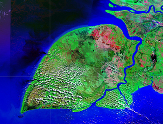
Pulau Kolepom or Pulau Yos Sudarso is an island separated only by the narrow Muli Strait from the main island of New Guinea. It is part of the Merauke Regency, in the Indonesian province of South Papua. The island is leaf-shaped, about 165 km (103 mi) long with an area of 11,740 km2 (4,530 sq mi). It was known as Frederik Hendrik Island until 1963. Local and alternative names of the island include Dolok and Kimaam.

Singapore is an island city-state and country in maritime Southeast Asia, located at the end of the Malayan Peninsula between Malaysia and Indonesia as well as the Straits of Malacca and the South China Sea. It is heavily compact and urbanised. As of 2023, Singapore has a total land area of 734.3 square kilometres (283.5 sq mi). Singapore is separated from Indonesia by the Singapore Strait and from Malaysia by the Straits of Johor.
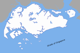
The Singapore Strait is a 113 km-long (70 mi), 19 km-wide (12 mi) strait between the Strait of Malacca in the west and the South China Sea in the east. Singapore is on the north of the channel, and the Indonesian Riau Islands are on the south. The two countries share a maritime border along the strait.

Tanjong Chek Jawa is a cape and the name of its 100-hectare wetlands located on the south-eastern tip of Pulau Ubin, an island off the north-eastern coast of the main island of Singapore. Chek Jawa is among the last few places left in Singapore with a natural rocky shore.

Changi Village is a modern village situated at the northern tip of Changi which is at the eastern end of Singapore. It is the usual connecting point for travellers heading to Pulau Ubin or Malaysia by ferry. Fishermen in the kelongs located in the Serangoon Harbour offshore also use this jetty as a drop off point to come onto mainland. Changi Village also has many resorts and leisure facilities to cater for a weekend getaway for many Singaporeans. The area is classified by Urban Redevelopment Authorities as under the planning area of Changi and in the subzone of Changi Point. It is also classified under District 17 for property indexing.
Pulau Bukom, also known as Pulau Bukum, is a small restricted-access island belonging to Singapore that is located about five kilometres to the south of Mainland Singapore, off the Straits of Singapore. The size of Pulau Bukom is about 1.45 km2 (0.56 sq mi).

Raffles Lighthouse is a lighthouse located on Pulau Satumu in the Singapore Strait, about 14 kilometres (8.7 mi) south of the main island of Singapore.

The early history of Singapore refers to its pre-colonial era before 1819, when the British East India Company led by Stamford Raffles established a trading settlement on the island and set in motion the history of modern Singapore.

The North-East Region of Singapore is one of the five regions in the country. The region is the most densely populated and has the highest population among the five, with Sengkang being its most populous town as of 2020 and Seletar as the regional centre. Comprising 13,810 hectares, it includes seven planning areas and is largely a residential region with 217,120 homes. Housing largely consists of high-density HDB public housing estates, however private housing is also present in the region. As its name implies, it is located in the north-eastern part of Singapore.
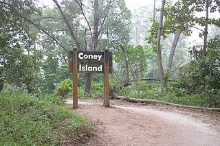
Coney Island, alternatively known as Pulau Serangoon, is a 133-hectare island located off the northeastern coast of Singapore within the town of Punggol, between Pulau Ubin to its northeast and the mainland to its southwest.
The North-Eastern Islands is a planning area and a group of islands located within the North-East Region of Singapore. The cluster is made up of three islands, namely Pulau Tekong, Pulau Tekong Kechil and Pulau Ubin. Pulau Tekong and Pulau Tekong Kechil was formerly home to 10 villages while Pulau Ubin was home to a number of granite quarries. At present, Pulau Tekong houses the Singapore Armed Forces Basic Military Training Centre while Pulau Ubin is one of the last areas in Singapore that has been preserved from urban development, concrete buildings and tarmac roads.

Serangoon Harbour is a harbour in Singapore located between the mainland island of Singapore and Pulau Ubin.
The names of Singapore include the various historical appellations as well as contemporary names and nicknames in different languages used to describe the island, city or country of Singapore. A number of different names have been given to the settlement or the island of Singapore all through history, the earliest record may have been from the 2nd century AD. Possible mentions of Pulau Ujong, the name for the island of Singapore, may be found in Chinese works, and it was also referred to as Temasek in Malay and Javanese literature. Sometime in the 14th century the name was changed to Singapura, which is now rendered as Singapore in English. Singapura means "Lion City" in Sanskrit, and Sang Nila Utama is usually credited with naming the city, although its actual origin is uncertain.

The German Girl Shrine is a shrine on the island of Pulau Ubin in Singapore. It marks the site of the burial of an unknown 18-year-old girl who died on the island in 1914 after falling from a cliff while fleeing from British forces who sought to detain a number of German nationals then resident on the island. Her body was recovered and interred in an urn on the site by Chinese workers, and a makeshift shrine structure was built. The site was visited frequently by gamblers who thought the spirit of the girl would bring them good luck. A permanent structure was erected in 1974 by a company carrying out quarrying on the island. Quarrying has since ceased, and the shrine is now within Ketam Mountain Bike Park. Visitors often leave offerings, including makeup and Barbie dolls, at the site.

