
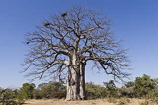
At 824,292 km2 (318,261 sq mi), Namibia is the world's thirty-fourth largest country. After Mongolia, Namibia is the second least densely populated country in the world. Namibia got its name from the Namib desert that stretches along the coast of the Atlantic. It is also known for its wildlife.

The Namib is a coastal desert in Southern Africa. According to the broadest definition, the Namib stretches for more than 2,000 kilometres (1,200 mi) along the Atlantic coasts of Angola, Namibia, and northwest South Africa, extending southward from the Carunjamba River in Angola, through Namibia and to the Olifants River in Western Cape, South Africa. The Namib's northernmost portion, which extends 450 kilometres (280 mi) from the Angola-Namibia border, is known as Moçâmedes Desert, while its southern portion approaches the neighboring Kalahari Desert. From the Atlantic coast eastward, the Namib gradually ascends in elevation, reaching up to 200 kilometres (120 mi) inland to the foot of the Great Escarpment. Annual precipitation ranges from 2 millimetres (0.079 in) in the aridest regions to 200 millimetres (7.9 in) at the escarpment, making the Namib the only true desert in southern Africa. Having endured arid or semi-arid conditions for roughly 55–80 million years, the Namib may be the oldest desert in the world and contains some of the world's driest regions, with only western South America's Atacama Desert to challenge it for age and aridity benchmarks.

The Namib-Naukluft Park is a national park in western Namibia, situated between the coast of the Atlantic Ocean and the edge of the Great Escarpment. It encompasses part of the Namib Desert, the Naukluft mountain range, and the lagoon at Sandwich Harbour. The best-known area of the park and one of the main visitor attractions in Namibia is Sossusvlei, a clay pan surrounded by dunes, and Sesriem, a small canyon of the Tsauchab. The desert research station of Gobabeb is situated within the park.

Swakopmund, is a city on the coast of western Namibia, 352 km (219 mi) west of the Namibian capital Windhoek via the B2 main road. It is the capital of the Erongo administrative district. As of 2011, the town had 44,725 inhabitants and 196 km2 (76 sq mi) of land. In 2023, the population had increased to 75,921 people.

The Kaokoveld Desert is a coastal desert of northern Namibia and southern Angola.

Alexander Bay is a town in the extreme north-west of South Africa. It is located on the southern bank of the Orange River mouth. It was named for Sir James Alexander, who was the first person to map the area whilst on a Royal Geographical Society expedition into Namibia in 1836. With diamonds being discovered along the West Coast in 1925, Alexander Bay was established to service the mining industry.

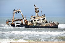
MV Dunedin Star was a British refrigerated cargo liner. She was built by Cammell Laird and Co in 1935–36 as one of Blue Star Line's Imperial Star-class ships, designed to ship frozen meat from Australia and New Zealand to the UK. The ship served in the Second World War and is distinguished for her role in Operation Halberd to relieve the siege of Malta in September 1941.
Iona National Park is the largest and oldest national park in Angola. It is situated in the Southwestern corner of the country, in Namibe Province. It is roughly bound by the Atlantic Ocean to the West, an escarpment to the East that marks the beginning of the interior plateau, the Curoca River to the North, and the Cunene River to the South. It is about 200 kilometres (120 mi) south of the city of Namibe and covers 5,850 square miles (15,200 km2) sq. miles.
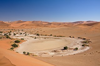
Sossusvlei is a salt and clay pan surrounded by high red dunes, located in the southern part of the Namib Desert, in the Namib-Naukluft National Park of Namibia. The name "Sossusvlei" is often used in an extended meaning to refer to the surrounding area. These landmarks are some of the major visitor attractions of Namibia.
The Gobabeb Namib Research Institute, short: Gobabeb, is a centre for dry land training and research in Namibia. It is located in the Namib Desert, 120 kilometres (75 mi) south-east of Walvis Bay.

Eduard Bohlen was a ship that was wrecked on the Skeleton Coast of German Southwest Africa on 5 September 1909 in a thick fog. The wreck currently lies in the sand 400 m (1,300 ft) from the shoreline.

Tourism in Namibia is a major industry, contributing N$7.2 billion to the country's gross domestic product. Annually, over one million travelers visit Namibia, with roughly one in three coming from South Africa, then Germany and finally the United Kingdom, Italy and France. The country is among the prime destinations in Africa and is known for ecotourism which features Namibia's extensive wildlife.

The Tsau ǁKhaeb (Sperrgebiet) National Park, formerly known as Sperrgebiet, is a diamond mining area in southwestern Namibia, in the Namib Desert. It spans the Atlantic Ocean-facing coast from Oranjemund on the border with South Africa, to around 72 kilometres (45 mi) north of Lüderitz, a distance of 320 km (200 mi) north. It extends to around 100 km (62 mi) inland, and its total area of 26,000 km2 (10,000 sq mi), makes up three percent of Namibia's land mass. However, mining only takes place in five percent of the Sperrgebiet, with most of the area acting as a buffer zone. Members of the public are banned from entering most of the area, despite the creation of a national park there in 2004.

Angola is located on the western Atlantic Coast of Southern Africa between Namibia and the Republic of the Congo. It also is bordered by the Democratic Republic of the Congo and Zambia to the east. The country consists of a sparsely watered and somewhat sterile coastal plain extending inland for a distance varying from 50 to 160 km. Slightly inland and parallel to the coast is a belt of hills and mountains and behind those a large plateau. The total land size is 1,246,700 km2 (481,400 sq mi). It has an Exclusive Economic Zone of 518,433 km2 (200,168 sq mi).
Skeleton Coast National Park is a national park located in northwest Namibia, and has the most inaccessible shores, dotted with shipwrecks. The park was established in 1971 and has a size of 16,845 km2 (6,504 sq mi). The park is divided into a northern and southern section, the southern section is open to those with 4-wheel drive vehicles, they are allowed to go up (north) as far as the Ugab River Gate. The northern section can only be reached by a fly-in safari, and the area is off-limits to all vehicles.
The Dorob National Park is a protected area in the Erongo region, along the central Namibian coast, which is 1,600 kilometres (990 mi) in length. It was gazetted as a national park under the Nature Conservation Ordinance No.4 of 1975 on 1 December 2010, and with Namib-Naukluft Park it covers an area of 107,540 square kilometres (41,520 sq mi).

Desert elephants or desert-adapted elephants are not a distinct species of elephant but are African bush elephants that have made their homes in the Namib and Sahara deserts in Africa. Previously they were classified as a subspecies of the African bush elephant, but this is no longer the case. Desert-dwelling elephants were once more widespread in Africa than they are at present; they are currently found only in Namibia and Mali. They tend to migrate from one waterhole to another following traditional routes which depend on the seasonal availability of food and water. They face being threatened by poaching and from changes in land use by humans.
The Huab River is an ephemeral river in the Kunene Region of north-western Namibia. Its source is southeast of Kamanjab, from where it flows westwards through Mopane savanna until it reaches the Skeleton Coast and the Atlantic Ocean. Inflows of the Huab are Klein-Omaruru, Sout, Aba-Huab, Ongwati and Klip. Huab's catchment area is estimated to be between 14,800 and 16,465 km2 (6,357 sq mi), and includes the town of Khorixas as well as the settlements Kamanjab, Fransfontein, and Anker. The Twyfelfontein World Heritage Site is located on the banks of the Aba Huab.
The Bom Jesus was a Portuguese nau and Indiaman that set sail from Lisbon, Portugal, on Friday, March 7, 1533. Its fate was unknown until 2008, when its remains were discovered during diamond mining operations on the coast of Namibia, near Oranjemund. Today, the Bom Jesus is the oldest known and most valuable shipwreck ever discovered off the Western coast of Sub-Saharan Africa.

 An aerial view of Skeleton Coast
 A map from 1964 to 1965 showing the Namibian "homelands" or Bantustans [8] when Namibia was under the rule of apartheid South Africa.
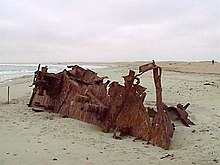
 Shipwreck of Eduard Bohlen
 Ugabmund Gate (Ugab River Gate) of the Skeleton Coast National Park; note the skulls-and-crossbones in the gate
 A dune formation on the coastline
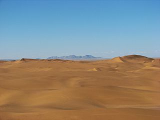


