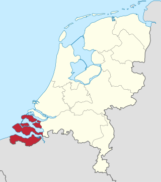
Zeeland is the westernmost and least populous province of the Netherlands. The province, located in the southwest of the country, borders North Brabant to the east, South Holland to the north, as well as the country of Belgium to the south and west. It consists of a number of islands and peninsulas and a strip bordering the Flemish provinces of East and West Flanders. Its capital is Middelburg with a population of 48,544 as of November 2019, although the largest municipality in Zeeland is Terneuzen. Zeeland has two seaports: Vlissingen and Terneuzen. Its area is 2,934 square kilometres (1,130 sq mi), of which 1,151 square kilometres (440 sq mi) is water; it has a population of 383,689.

The Eastern Scheldt is a former estuary in the province of Zeeland, Netherlands, between Schouwen-Duiveland and Tholen on the north and Noord-Beveland and Zuid-Beveland on the south. It also features the largest national park in the Netherlands, founded in 2002.

Walcheren is a region and former island in the Dutch province of Zeeland at the mouth of the Scheldt estuary. It lies between the Eastern Scheldt in the north and the Western Scheldt in the south and is roughly the shape of a rhombus. The two sides facing the North Sea consist of dunes and the rest of its coastline is made up of dykes. Middelburg, the provincial capital, lies at Walcheren's centre. Vlissingen, 9 kilometres (5.6 mi) to the south, is the main harbour and the third municipality is Veere.

Noord-Beveland is a municipality and region in the southwestern Netherlands and a former island, now part of the Walcheren-Zuid-Beveland-Noord-Beveland peninsula. Noord-Beveland is enclosed by the Oosterschelde estuary to the north, and the former straits, now combined lake, of Veerse Meer and Zandkreek to the south. As part of the Delta Works, dams have connected Noord-Beveland to Walcheren and Zuid-Beveland.

Veere is a municipality with a population of 22,000 and a town with a population of 1,500 in the southwestern Netherlands, in the region of Walcheren in the province of Zeeland.

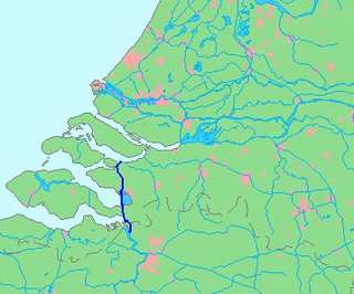
The Western Scheldt in the province of Zeeland in the southwestern Netherlands, is the estuary of the Scheldt river. This river once had several estuaries, but the others are now disconnected from the Scheldt, leaving the Westerschelde as its only direct route to the sea. The Western Scheldt is an important shipping route to the Port of Antwerp, Belgium. Unlike the Eastern Scheldt estuary, it could not be closed off from the sea by a dam as part of the Delta Works. Instead, the dykes around it have been heightened and reinforced.

Zeelandic Flanders is the southernmost region of the province of Zeeland in the south-western Netherlands. It lies south of the Western Scheldt that separates the region from the remainder of Zeeland and the Netherlands to the north. Zeelandic Flanders is bordered to the south and to the east by Belgium.

Zuid-Beveland is part of the province of Zeeland in the Netherlands north of the Western Scheldt and south of the Eastern Scheldt.
The Scheldt–Rhine Canal (Schelde-Rijnkanaal) in Belgium and the Netherlands connects Antwerp with the Volkerak, and thereby the Scheldt with the Rhine.

The Canal through Walcheren in the Netherlands crosses the east of Walcheren. It connects the Westerschelde and the Veerse Meer.

The Veerse Meer is a lagoon in the southwest Netherlands in the province of Zeeland.
The Battle of Walcheren Causeway was an engagement of the Battle of the Scheldt between the 5th Canadian Infantry Brigade, elements of the British 52nd (Lowland) Infantry Division and troops of the German 15th Army in 1944. It was the first of many conflicts on and around Walcheren Island during the Scheldt battles. It was also the second major battle fought over a terrain feature known as the Sloedam during the Second World War.

Operation Infatuate was the code name given to an Anglo-Canadian operation in November 1944 during the Second World War to open the port of Antwerp to shipping and relieve logistical constraints. The operation was part of the wider Battle of the Scheldt and involved two assault landings from the sea by the 4th Special Service Brigade and the 52nd (Lowland) Division. Meanwhile, the 2nd Canadian Infantry Division would force a crossing of the Walcheren Causeway.
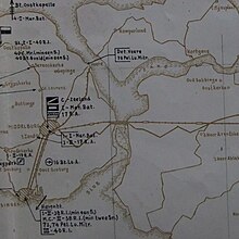
The Battle of Zeeland occurred on the Western Front during the early stages of the German assault on France and the Low Countries during World War II. Several Dutch and French units attempted to hold off the German onslaught by making a determined defense of the Dutch province of Zeeland. The battle lasted eight days and was a defeat for the French and Dutch forces defending the province.

In August 1572, during the course of the Eighty Years' War, the city of Goes, in the Spanish Netherlands, was besieged by Dutch forces with the support of English troops sent by Queen Elizabeth I. This was a menace to the safety of the nearby city of Middelburg, also under siege. Given the impossibility of rescue of Goes by sea, 3,000 soldiers of the Spanish Tercios under the command of Cristóbal de Mondragón waded across the river Scheldt at its mouth, walking 15 miles overnight in water up to chest deep. The surprise arrival of the Tercios forced the withdrawal of the Anglo-Dutch troops from Goes, allowing the Spanish to maintain control of Middelburg, capital of Walcheren Island.
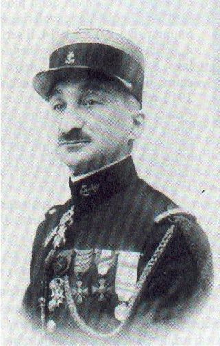
Marcel Émile Deslaurens was a French brigadier general. He died in World War II during an act of gallantry that allowed a number of his men to retreat safely.

The Inundation of Walcheren was the intentional, but uncontrolled military inundation, effected by bombing the sea dikes of the former island of Walcheren in Zeeland by the Allies on and after 3 October 1944 in the context of Operation Infatuate during the Battle of the Scheldt after the Allied Invasion of Normandy during World War II. Though the inundation was justified by military necessity, it is controversial whether it was proportional in view of the predictable devastating effects for the civilian population, and the ecology of the island. The fact that the breaches in the sea dikes of the island remained open for a very long time, subjecting the island to the full impact of the twice-daily tides, caused severe damage to agricultural land and infrastructure, and severe hardship for the civilian population. Leaving the breaches open for such a long time, which was unavoidable due to the war-time lack of resources making closing impossible, subjected them to scouring by the tides, that widened and deepened them to such an extent that closing them eventually became extremely difficult, necessitating the development of new dike-building techniques, such as the use of caissons. The last breach was closed on 23 October 1945 and the draining of the island took until early 1946. Only after that could rebuilding the infrastructure and reconstructing the housing stock and the island's economy start. Walcheren was spared during the North Sea Flood of 1953 that devastated many other parts of Zeeland.

The Veerse Gatdam is a man-made barrier across the former estuary known as the Veerse Gat, between Walcheren and Noord-Beveland islands in Zeeland, Netherlands. The barrier was completed on 27 April 1961. Because of the completion of this barrier, the Veerse Meer was created. The Veerse Gatdam is the third structure constructed as part of the Delta Works water management system. The N57 motorway runs along the top of the barrier.
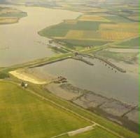
The Zandkreekdam is a compartmentalisation dam located approximately 3 kilometres north of the city of Goes in The Netherlands, which connects Zuid-Beveland with Noord-Beveland, and separates the Oosterschelde from the Veerse Meer.
The Kreekrakdam is a 3.5 km long dam, that was constructed from 1861 to 1867 as a necessary part of the Roosendaal-Vlissingen Railway, the so-called Zeeuwse Lijn. Additionnaly this dam connected the island of Zuid-Beveland with the mainland of Brabant across the Kreekrak waterway.