Smardale

Last updated

Smardale
Smardale Hall - geograph.org.uk - 129439.jpg
Smardale Hall, Smardale
Location map United Kingdom Eden.svg
Red pog.svg
Smardale
Location in Eden, Cumbria
Cumbria UK location map.svg
Red pog.svg
Smardale
Location within Cumbria
OS grid reference NY738081
Civil parish
District
Shire county
Region
Country England
Sovereign state United Kingdom
Post town KIRKBY STEPHEN
Postcode district CA17
Dialling code 017683
Police Cumbria
Fire Cumbria
Ambulance North West
UK Parliament
List of places
UK
England
Cumbria
54°28′05″N2°24′11″W / 54.468°N 2.403°W / 54.468; -2.403 Coordinates: 54°28′05″N2°24′11″W / 54.468°N 2.403°W / 54.468; -2.403

Smardale is a small village and former civil parish, now in the parish of Waitby, in the Eden district, in Cumbria, England. In 1891 the parish had a population of 36. [1]

Contents

Geography and history

The village of Smardale lies in hilly agricultural land at a height of around 220 m (720 ft)1.1 miles (1.75 km) southeast of Crosby Garrett and 2.2 miles (3.5 km) west of Kirkby Stephen. To the south is Smardale fell whilst a boundary is formed to the west by Scandal Beck which flows from Smardalegill, a narrow valley to the southwest.

The name Smaredale may derive from smere, an ancient name for clover, [2] [3] or from the old Norse or old English for butter/fat/grease [4] giving either valley of butter or valley of clover.

Chapel well, a Holy well, is found west of Scandal Beck where it once stood within Smardale church. [5] [6] [7] There are also other signs of ancient human activity: the archaeological remains of settlements are found on Smardale fell, and around Smardalegill, pillow mounds, known locally as 'Giant's graves' which are thought by some to be for drying bracken, and not for rabbits. Oxenbrow wood, to the north of Smardale village is the site of a Heronry. [8]

Smardale was formerly a township in Kirkby-Stephen parish, [9] from 1866 Smardale was a civil parish in its own right until it was abolished on 30 December 1894 and merged with Waitby. [10]

Smardale Hall

There has been a substantial dwelling in Smardale since at least the 14th century; a tower house, a remnant of which, a newel, now forms part of the structure of the south eastern part of the current house. [11]

The current buildings date from 15th and 16th centuries; being originally built on a courtyard plan with the tower incorporated into an east wing, now demolished. The southern part of the hall (now farm buildings) was the original great hall. Sir George Dalston, the castles occupant from 1761 made considerable alterations to the structure. [12] The west wing, which is the current hall is unusual in having four conically roofed round towers at the corners of the structure, [13] giving the structure an appearance similar to the Scottish baronial style of architecture.

The hall and associated buildings are Grade II* listed structures (since 1968). [14] There is evidence for an earlier fortified structure from a motte and ditch discovered north of the hall. [15]

Smardale Gill

Smardalegill is a small steep-sided valley connecting Smardale and the valley of the River Eden with the eastern end of the valley of the River Lune. Scandal Beck runs north-northeast through it, as does the former Stainmore Railway.

Smardale Gill quarry was a large limestone quarry on the west side of Smardale Gill. Lime was produced on site at two limekilns with raw materials brought to the top of the kilns using an inclined plane and a stationary engine. A railway siding on the Stainmore line next to the kilns allowed lime to be carried away by rail. The limekilns and evidence of the engine house and inclined plane are extant. [16]

Smardale Gill nature reserve is a national nature reserve (NNR) and Site of Special Scientific Interest managed by the Cumbria Wildlife Trust. [17] Land in Smardale Gill was first acquired in 1978. Later in 1991 the reserve acquired the trackbed of the former Stainmore railway from Smardale to Brownber from British Rail [18] [19] The site contains both woodland and grassland habitats and is a good example of a limestone habitat.

At the south end of the valley on the border with Ravenstonedale civil parish is the 18th-century arched stone packhorse bridge known as Smardale bridge, now a Grade II listed structure. [20] [21]

There is a small disused sandstone quarry at the south of the gill. [22]

Railways

Two railway lines ran through Smardale and past the village. The Stainmore Railway passed Smardale on the northern edge of the village, where there was a small halt, Smardale railway station (now a private dwelling). Going westwards it then crossed under the Settle to Carlisle railway line just east of Scandal Beck before curving south through Smardalegill along the east bank. Within Smardalegill the line crosses the beck at a shallow angle by Smardalegill Viaduct. The Settle to Carlisle railway line passes Smardale village to the south, travelling east–west; to the west the line crosses Scandal Beck by Smardale Viaduct.

Smardale Gill Viaduct from the southwest Smardale Gill Viaduct from SW 16.08.16.jpg
Smardale Gill Viaduct from the southwest
Smardale Gill Viaduct's restored upper deck for use by walkers Smardale Gill Viaduct upper deck 16.08.16.jpg
Smardale Gill Viaduct's restored upper deck for use by walkers

Smardale Gill Viaduct predates Smardale Viaduct, being complete in 1861. The viaduct was designed by Sir Thomas Bouch for the South Durham and Lancashire Union Railway and the construction contracted to Mr Wrigg, costing £11,928 to build. The bridge, which was built of local stone has 14 arches, and is 90 ft (27 m) high and 550 ft (170 m) long. The line across it remained single tracked despite the structure being wide enough for a double line. [23] [24]

After the line closed in 1962 the viaduct fell into disrepair, by the 1980s the structure had become dangerous and was to be demolished. Instead the viaduct became a listed building, and British Rail offered £230,000 (the estimated cost of demolition) towards its restoration. A charitable trust, the Northern Viaduct Trust was formed in 1989. The cost of repairs was £350,000 which included masonry repair, a new deck and waterproofing, and structural work to the viaduct. [25] In 1992 the restoration was complete, the viaduct being subsequently used for pedestrian access to Smardale Gill nature reserve. [23] [26]

In 2010 after a harsh winter it was found that the viaduct had frost damage and required a further £30,000 of repairs. [27]

Smardale Viaduct Train on Smardale Viaduct.jpg
Smardale Viaduct

Smardale Viaduct was built by the contractors Benton & Woodiwiss for the Settle to Carlisle Line of the Midland Railway. The viaduct is 710 ft (220 m) long and 130 ft (40 m) high, the highest on the line. Over 60,000 long tons (61,000 t) of stone was used in its construction. [28] Local limestone was used for its construction, the arch quoins were of millstone grit. Two of the twelve piers – the fourth and the tenth are of considerably heavier construction. The bridge opened in August 1875 having taken five years to construct, it crosses both Scandal Beck and the former Stainmore railway line. [29] [30]

See also

Related Research Articles

<span class="mw-page-title-main">River Eden, Cumbria</span> River in Cumbria, England

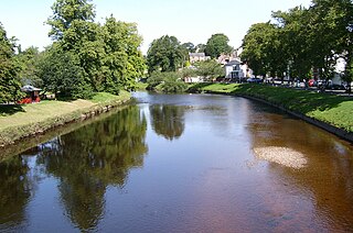
The River Eden is a river that flows through the Eden District of Cumbria, England, on its way to the Solway Firth.

<span class="mw-page-title-main">Eden Valley Railway</span> Former railway

The Eden Valley Railway (EVR) was a railway in Cumbria, England. It ran between Clifton Junction near Penrith and Kirkby Stephen via Appleby-in-Westmorland.

<span class="mw-page-title-main">Kirkby Stephen</span> Market town in Cumbria, England

Kirkby Stephen is a market town and civil parish in Cumbria, North West England. Historically part of Westmorland, it lies on the A685, surrounded by sparsely populated hill country, about 25 miles (40 km) from the nearest larger towns: Kendal and Penrith. The River Eden rises 6 miles (9.7 km) away in the peat bogs below Hugh Seat and passes the eastern edge of the town. At the 2001 census the parish had a population of 1,832. In 2011, it had a population of 1,522.

<span class="mw-page-title-main">Orton, Eden</span> Village in Cumbria, England

Orton is a village and civil parish in Cumbria, England. It lies 15 miles (24 km) south of Penrith, 8 miles (13 km) from Appleby-in-Westmorland and 1.5 miles (2.4 km) from the M6 motorway. The village is in the upper Lune Valley, at the foot of Orton Scar in the Orton Fells. The Lake District is nearby. The parish includes a wide area outside the village, and had a population of 594 in 2001, decreasing to 588 at the 2011 Census.

<span class="mw-page-title-main">Clifton, Cumbria</span> Human settlement in England

Clifton is a small linear village and civil parish in Cumbria, England. Historically part of Westmorland, it lies 3 miles (4.8 km) south east of Penrith.

The Barony of Westmorland also known as North Westmorland, the Barony of Appleby, Appleshire or the Bottom of Westmorland, was one of two baronies making up the English historical county of Westmorland, the other being the Barony of Kendal. Geographically, the barony covered the northern part of the larger county of the same name, and was divided into two wards – East Ward and West Ward. It covered an area similar to that of the Eden District of the new county of Cumbria, although it did not include Penrith, which is now the administrative capital of the district.

<span class="mw-page-title-main">Brough, Cumbria</span> Human settlement in England

Brough, sometimes known as Brough under Stainmore, is a village and civil parish in the Eden district of Cumbria, England, on the western fringe of the Pennines near Stainmore. The village is on the A66 trans-Pennine road, and the Swindale Beck, and is about 8 miles (13 km) south east of Appleby-in-Westmorland. Brough is situated 5 miles (8.0 km) north east of Kirkby Stephen and 28 miles (45 km) north east of Kendal on the A685.

<span class="mw-page-title-main">South Durham and Lancashire Union Railway</span> English railway company

The South Durham & Lancashire Union Railway (SD&LUR) built a railway line linking the Stockton & Darlington Railway near Bishop Auckland with the Lancaster and Carlisle Railway at Tebay, via Barnard Castle, Stainmore Summit and Kirkby Stephen. The line opened in 1861 and became known as the Stainmore Line.

Kirkby Stephen East railway station was situated on the South Durham & Lancashire Union Railway between Barnard Castle and Tebay. It served the town of Kirkby Stephen in England and was a junction station for the Eden Valley Railway.

Smardale railway station was a minor station on the South Durham & Lancashire Union Railway between Tebay and Kirkby Stephen East. It served the villages of Smardale and Waitby. The station opened to passenger traffic on 8 August 1861, and closed on 1 December 1952.

<span class="mw-page-title-main">Stainmore Railway Company</span>

Stainmore Railway Company is a volunteer-run, non-profit preservation company formed in 2000 with the aim of restoring Kirkby Stephen East railway station in Kirkby Stephen, Cumbria, England. In 1997 a company called Stainmore Properties Ltd. was formed, with the intention to convert KSE into an authentic North Eastern Railway focused heritage centre representing the early 1950s. The Stainmore Railway Company was subsequently formed to restore the site. Since then essential repairs have been made to the roof and station, a number of rooms have been restored and a short section of track has been laid along the formation of the old Eden Valley Railway, with some sidings and yard infrastructure within the station area and surroundings. A quantity of rolling stock that is authentic to the site has also been brought in.

<span class="mw-page-title-main">Newbiggin-on-Lune</span> Human settlement in England

Newbiggin-on-Lune is a village in the Eden district of Cumbria, England. Historically in Westmorland it is about 4 miles (6.4 km) south west of Kirkby Stephen, and lies on the main A685 route from Brough to Tebay. Nearby to the north is located the Smardale Gill Viaduct on the dismantled former South Durham & Lancashire Union Railway between Tebay and Kirkby Stephen East railway station. To the south lies the Howgill Fells including Green Bell 1,985 feet.

<span class="mw-page-title-main">Dentdale</span> Valley in Cumbria, England

Dentdale is a dale or valley in the north-west of the Yorkshire Dales National Park in Cumbria, England. It is the valley of the River Dee, but takes its name from the village of Dent. The dale runs east to west, starting at Dent Head, which is the location of a railway viaduct on the Settle-Carlisle Line.

<span class="mw-page-title-main">Crosby Garrett</span> Human settlement in England

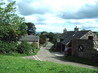
Crosby Garrett is a hamlet and civil parish in the Eden District of Cumbria, England. It was formerly in the county of Westmorland. In the 2011 census Crosby Garrett was grouped with Waitby to give a total of 195.

<span class="mw-page-title-main">Stainmore</span> Human settlement in England

Stainmore is a remote geographic area in the Pennines on the border of Cumbria, County Durham and North Yorkshire. The name is used for a civil parish in the Eden District of Cumbria, England, including the villages of North Stainmore and South Stainmore. The parish had a population of 253 in the 2001 census, increasing to 264 at the Census 2011. Stainmore Forest stretches further east into County Durham, towards Bowes.

<span class="mw-page-title-main">Waitby</span> Human settlement in England

Waitby is a small village and civil parish in the Eden district of Cumbria, England. The parish contains two small villages, Waitby and Smardale, plus the small hamlets of Riddlesay, Stripes and Leases, all of which are in the farmed and enclosured northern part at an elevation of around 200–300m. The southern half of the parish is mostly heath and unused for agriculture, it rises to Smardale fell; which it includes, at elevations between 300 and 400m. The civil parish of Ravenstonedale forms the boundary to the south. The western border with Crosby Garrett civil parish is formed by Scandal Beck. To the north and east lie Soulby and Kirkby Stephen civil parishes respectively. The population of the civil parish as measured at the 2011 Census was less than 100. Details are included in the parish of Crosby Garrett.

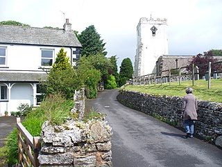
Waitby is a civil parish in the Eden District, Cumbria, England. It contains nine listed buildings that are recorded in the National Heritage List for England. Of these, one is listed at Grade II*, the middle of the three grades, and the others are at Grade II, the lowest grade. The parish contains the villages of Waitby and Smardale and is otherwise rural. The listed buildings consist of houses and associated structures, farmhouses and farm buildings, and a bridge, a boundary stone, and a former school.

<span class="mw-page-title-main">Arten Gill Viaduct</span> Railway viaduct in Cumbria, England

Arten Gill Viaduct is an eleven-arch railway bridge in Dentdale, Cumbria, England. The viaduct carries the Settle to Carlisle railway line over Artengill Beck. The viaduct was originally designed to be further west, which is lower down the steep valley side, but by moving the line slightly eastwards, the viaduct could be installed at a higher location, thereby using fewer materials in its height. Arten Gill Viaduct is constructed partly from Dent Marble in the inside of the arches instead of the more usual brick. Dent Marble is a type of dark limestone which was quarried from Artengill beneath the viaduct itself. The viaduct is a grade II listed structure, and a scheduled monument.

References

  1. "Population statistics Smardale Tn/Ch/CP through time". A Vision of Britain through Time . Retrieved 13 January 2022.
  2. Nicolson, Joseph; Burn, Richard; Nicolson, William; Hornyold-Strickland, Henry (1777), The history and antiquities of the counties of Westmorland and Cumberland, vol. 1, pp. 554–555 "Manor of Smardale"
  3. Mannex, P.J. (1849), History, topography, and directory, of Westmorland: and Londsdale north of the sands, in Lancashire together with a descriptive and geological view of the whole of the Lake district, Simpkin, Marshall, & co., p.161 'Smardale', hdl: 2027/mdp.39015074814057
  4. Mills, A.D. (2011), A Dictionary of British Place-Names, Smardale, ISBN   9780199609086
  5. Curwen 1932, Chap. 16, The Parish of St. Andrew, Crosby Garrett, Antiquities.
  6. Curwen 1932, Chap.18, The Parish of St. John, Kirkby Stephen, Smardale Chapel.
  7. Lewis, Samuel (1835), A topographical dictionary of England, vol. 4, "Smardale"
  8. "Smardale", www.visitoruk.com
  9. "History of Smardale, in Eden and Westmorland". A Vision of Britain through Time. Retrieved 13 January 2022.
  10. "Relationships and changes Smardale Tn/Ch/CP through time". A Vision of Britain through Time. Retrieved 13 January 2022.
  11. Historic England. "Smardale Hall (14713)". Research records (formerly PastScape). Retrieved 29 November 2013.
  12. Curwen 1932, Chap. 18.
  13. Historic England. "Swardale Hall and adjoining buildings (1326959)". National Heritage List for England . Retrieved 29 November 2013.
  14. Historic England. "Details from listed building database (1326959)". National Heritage List for England . Retrieved 25 August 2017.
  15. Historic England. "Defensive site (14738)". Research records (formerly PastScape). Retrieved 29 November 2013.
  16. "Smardale Gill Limestone Quarry (United Kingdom)", www.aditnow.co.uk
  17. "Smardale Gill NNR", www.naturalengland.org.uk
  18. "Smardale Gill National Nature Reserve – Near Kirkby Stephen" (PDF), www.wildlifecumbria.org.uk
  19. "Smardale Gill", www.cumbriawildlifetrust.org.uk
  20. Historic England. "Smardale Bridge over Scandal Beck South of Smardalegill Viaduct, Waitby (1312391)". National Heritage List for England . Retrieved 29 November 2013.
  21. Historic England. "Smardale Bridge over Scandal Beck South of Smardalegill (1312391)". National Heritage List for England . Retrieved 29 November 2013.
  22. "Abandoned sandstone quarries, Smardale Gill", www.geograph.org.uk
  23. 1 2 "Smardale Gill Old Viaduct", www.visitcumbria.com
  24. About Smardale Viaduct, Northern Viaduct Trust, www.nvt.org.uk
  25. Burman, Peter; Stratton, Michael (1997), Conserving the railway heritage, "The challenge of disused railway viaducts", Charles Blackett-Ord, pp. 226–7
  26. "The Northern Viaducts Trust", www.nvt.org.uk, retrieved 29 November 2013
  27. "Eden viaduct needs urgent repair", The Westmorland Gazette , 27 July 2010
  28. Williams, F.S. (1888), "VII. Viaducts", Our Iron Roads: their history, construction and administration, pp. 183–185
  29. Rennison, Robert William (1996), Civil engineering heritage: Northern England, "Smardale Viaduct" , pp.111–112
  30. "Smardale Viaduct", www.engineering-timelines.com

Sources